


CNIG presents a new version of its Download Center


Fecha de la noticia: 03-05-2017
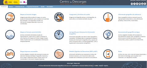
A new version of the Download Center of the National Geographic Information Center was published in April. An website portal to download free digital open data files produced by the General Directorate of the National Geographic Institute.
In addition to a more user-friendly and attractive redesign of the site, the Download Center has improved the way information is organized so users can navigate the platform more easily, while improving adaptation to mobile devices and modifying the search options. Thanks to the users´ feedback, the CNIG has been able to detect weak spots in its download centre, especially those related to the identification and location of datasets. As a result CNIG has created nine clusters to simplify dataset searches. At the same time, a FAQ section based on the queries sent by users in the last three years has been added.
In the previous version of the Download Centre, all data were managed through a relational database, which was not prepared for the spatial search of products despite working with geographic information. To solve this problem, the geoportal has implemented to management of the download files a spatial database and a spatial footprint of all the files that make up the fifty products available from the download centre.
What does this change mean? The ways to search for information have been expanded, allowing files to be located through a wider range of criteria such as place name, post code, MTN50 sheet, uploading a file (kml, gpx or shape) or a simple point drawn on the map. In addition, the majority of data can be viewed WMS or WMTS servicess, a layer has been included to display the information that is made available to users.
This new version provides a process to download the files directly from the results options by selecting them one by one, or adding them to the download to download them automatically through a JAVA application.
Thanks to these changes, CNIG continues to advance in the openness and re-use of geospatial information in Spain, which is included in the group of thirteen high value datasets of the Global Open Data Index thanks to its potential to be re-used both in business decision making, development of new products and the implementation of services, and to its positive impact in the socio-economic sphere.


