Publication date
15/11/2023
Update date
06/06/2025

Description
The Canary Islands Statistics Institute (ISTAC) has taken a significant step forward in the volume of geographic data thanks to the publication of a total of 4,002 new datasets (3,859 thematic maps and 143 statistical cubes) in datos.gob.es, following its federation in Canarias Datos Abiertos.
This type of initiative is aligned with the European Union's Data Strategy, which establishes the guidelines to achieve a single data market that benefits companies, researchers and public administrations. The automation of publication processes through common standards is key to ensure interoperability and adequate access to open data sets of public administrations.
The generation of these datasets is the culmination of an automation work that has allowed the expansion of the number of published cubes, as now combinations of granularity and year since 2004 are presented. In early October, the ISTAC added to its catalog more than 500 semantic assets and more than 2100 statistical cubes, as we told in this post on datos.gob.es.
In addition, the sets published to date have undergone a renewal process to become the aforementioned 143 statistical cubes. The increase of these datasets not only improves the directory of datos.canarias.es and datos.gob.es in quantitative terms, but also broadens the uses it offers thanks to the type of information added.
The indicators of these cubes are represented on the cartography through choropleth maps and in multiple formats. This automation will, in turn, not only allow other datasets to be published more easily in the future, but also more frequently.
Another of the advances of this work is that the services are generated on the fly from the Geoserver map server, and not through an upload to CKAN, as was done until now, which reduces their storage and speeds up their updating.
How to bring demographic indicators closer to the population
Demographic indicators are dense data cubes that offer a large amount of detailed geographic information, including total population, disaggregated by sex, residence, age and other indices up to a total of 27 different variables.
As so much information is contained in each cube, it can be difficult to represent specific indicators on the cartography, especially if the user is not used to working with certain GIS (Geographical Information System) software.
To bring this content to all types of users, the ISTAC has generated 3,859 new maps, representing on a choropleth map each of the indicators contained in the 143 statistical cubes. The publication of these new cartographic data is thus presented as a more efficient and simplified way of obtaining the information already represented, allowing users to easily access the specific data they need.
We could compare this transformation to flowers. Previously, only whole bouquets were published, with 27 flowers per bouquet, which had to be managed and handled to represent the flowers that were of interest. Now, in addition to continuing to publish the bouquets, new processes have been generated to be able to publish each flower separately, automating the generation of each of these sets, which will also be updated more frequently.
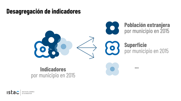
This new option facilitates the use of these choropleth maps (like the one shown in the image) by people without technical GIS knowledge, since they are presented in easily downloadable formats as images (.jpg and .png) for professional, educational or personal use.
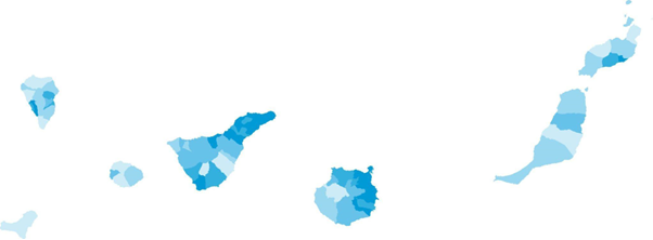

Mapa de población de 65 o más años (% sobre total) por municipios. Año 2022
For more advanced users, ISTAC has also expanded the range of formats in which the original indicator cubes are served. The "bouquets", which previously only showed data in CSV format, now have a wide variety of distributions: KML, GML, GeoPackage, GeoJSON, WFS, WMS. Taking advantage of the benefits provided by the use of styles in the WMS format, all the styles associated with the indicators have been generated, so that, using them, it is possible to represent the same map that is downloaded in image format. These styles are calculated for each indicator-granularity-year combination, according to the method of calculating quantiles for five intervals.
This new approach with both simple and complex geographic data enriches the catalog and allows users without specific knowledge to access and reuse them. In addition, it should be noted that this opens the door to other massive publications of data based on other statistical operations.
In short, this is an important step in the process of opening up data. A process that improves the use and sharing of data, both for the user on the ground and for professionals in the sector. Given the growing need to share, process and compare data, it is essential to implement processes that facilitate interoperability and appropriate access to open data. In this sense, the Canary Islands Institute of Statistics is concentrating its efforts to ensure that its open data sets are accessible and in the appropriate formats for sharing. All this in order to obtain value from them.


Comments