Publication date
11/09/2025
Update date
21/01/2026

Description
Synthetic images are visual representations artificially generated by algorithms and computational techniques, rather than being captured directly from reality with cameras or sensors. They are produced from different methods, among which the antagonistic generative networks (Generative Adversarial NetworksGAN), the Dissemination models, and the 3D rendering techniques. All of them allow you to create images of realistic appearance that in many cases are indistinguishable from an authentic photograph.
When this concept is transferred to the field of Earth observation, we are talking about synthetic satellite images. These are not obtained from a space sensor that captures real electromagnetic radiation, but are generated digitally to simulate what a satellite would see from orbit. In other words, instead of directly reflecting the physical state of the terrain or atmosphere at a particular time, they are computational constructs capable of mimicking the appearance of a real satellite image.
The development of this type of image responds to practical needs. Artificial intelligence systems that process remote sensing data require very large and varied sets of images. Synthetic images allow, for example, to recreate areas of the Earth that are little observed, to simulate natural disasters – such as forest fires, floods or droughts – or to generate specific conditions that are difficult or expensive to capture in practice. In this way, they constitute a valuable resource for training detection and prediction algorithms in agriculture, emergency management, urban planning or environmental monitoring.
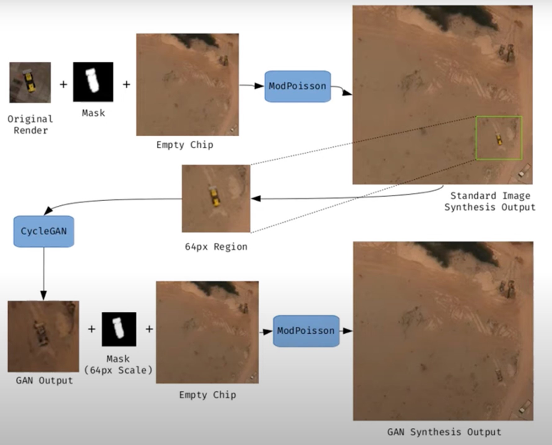
Figure 1. Example of synthetic satellite image generation.
Its value is not limited to model training. Where high-resolution images do not exist – due to technical limitations, access restrictions or economic reasons – synthesis makes it possible to fill information gaps and facilitate preliminary studies. For example, researchers can work with approximate synthetic images to design risk models or simulations before actual data are available.
However, synthetic satellite imagery also poses significant risks. The possibility of generating very realistic scenes opens the door to manipulation and misinformation. In a geopolitical context, an image showing non-existent troops or destroyed infrastructure could influence strategic decisions or international public opinion. In the environmental field, manipulated images could be disseminated to exaggerate or minimize the impacts of phenomena such as deforestation or melting ice, with direct effects on policies and markets.
Therefore, it is convenient to differentiate between two very different uses. The first is use as a support, when synthetic images complement real images to train models or perform simulations. The second is use as a fake, when they are deliberately presented as authentic images in order to deceive. While the former uses drive innovation, the latter threatens trust in satellite data and poses an urgent challenge of authenticity and governance.
Risks of satellite imagery applied to Earth observation
Synthetic satellite imagery poses significant risks when used in place of images captured by real sensors. Below are examples that demonstrate this.
A new front of disinformation: "deepfake geography"
The term deepfake geography has already been consolidated in the academic and popular literature to describe fictitious satellite images, manipulated with AI, that appear authentic, but do not reflect any existing reality. Research from the University of Washington, led by Bo Zhao, used algorithms such as CycleGAN to modify images of real cities—for example, altering the appearance of Seattle with non-existent buildings or transforming Beijing into green areas—highlighting the potential to generate convincing false landscapes.
One OnGeo Intelligence (OGC) platform article stresses that these images are not purely theoretical, but real threats affecting national security, journalism and humanitarian work. For its part, the OGC warns that fabricated satellite imagery, AI-generated urban models, and synthetic road networks have already been observed, and that they pose real challenges to public and operational trust.
Strategic and policy implications
Satellite images are considered "impartial eyes" on the planet, used by governments, media and organizations. When these images are faked, their consequences can be severe:
- National security and defense: if false infrastructures are presented or real ones are hidden, strategic analyses can be diverted or mistaken military decisions can be induced.
- Disinformation in conflicts or humanitarian crises: An altered image showing fake fires, floods, or troop movements can alter the international response, aid flows, or citizens' perceptions, especially if it is spread through social media or media without verification.
- Manipulation of realistic images of places: not only the general images are at stake. Nguyen et al. (2024) showed that it is possible to generate highly realistic synthetic satellite images of very specific facilities such as nuclear plants.
Crisis of trust and erosion of truth
For decades, satellite imagery has been perceived as one of the most objective and reliable sources of information about our planet. They were the graphic evidence that made it possible to confirm environmental phenomena, follow armed conflicts or evaluate the impact of natural disasters. In many cases, these images were used as "unbiased evidence," difficult to manipulate, and easy to validate. However, the emergence of synthetic images generated by artificial intelligence has begun to call into question that almost unshakable trust.
Today, when a satellite image can be falsified with great realism, a profound risk arises: the erosion of truth and the emergence of a crisis of confidence in spatial data.
The breakdown of public trust
When citizens can no longer distinguish between a real image and a fabricated one, trust in information sources is broken. The consequence is twofold:
- Distrust of institutions: if false images of a fire, a catastrophe or a military deployment circulate and then turn out to be synthetic, citizens may also begin to doubt the authentic images published by space agencies or the media. This "wolf is coming" effect generates skepticism even in the face of legitimate evidence.
- Effect on journalism: traditional media, which have historically used satellite imagery as an unquestionable visual source, risk losing credibility if they publish doctored images without verification. At the same time, the abundance of fake images on social media erodes the ability to distinguish what is real and what is not.
- Deliberate confusion: in contexts of disinformation, the mere suspicion that an image may be false can already be enough to generate doubt and sow confusion, even if the original image is completely authentic.
The following is a summary of the possible cases of manipulation and risk in satellite images:
|
Ambit |
Type of handling |
Main risk |
Documented example |
|---|---|---|---|
| Armed conflicts | Insertion or elimination of military infrastructures. | Strategic disinformation; erroneous military decisions; loss of credibility in international observation. | Alterations demonstrated in deepfake geography studies where dummy roads, bridges or buildings were added to satellite images. |
| Climate change and the environment | Alteration of glaciers, deforestation or emissions. | Manipulation of environmental policies; delay in measures against climate change; denialism. | Studies have shown the ability to generate modified landscapes (forests in urban areas, changes in ice) by means of GANs. |
| Gestión de emergencias | Creation of non-existent disasters (fires, floods). | Misuse of resources in emergencies; chaos in evacuations; loss of trust in agencies. | Research has shown the ease of inserting smoke, fire or water into satellite images. |
| Mercados y seguros | Falsification of damage to infrastructure or crops. | Financial impact; massive fraud; complex legal litigation. | Potential use of fake images to exaggerate damage after disasters and claim compensation or insurance. |
| Derechos humanos y justicia internacional | Alteration of visual evidence of war crimes. | Delegitimization of international tribunals; manipulation of public opinion. | Risk identified in intelligence reports: Doctored images could be used to accuse or exonerate actors in conflicts. |
| Geopolítica y diplomacia | Creation of fictitious cities or border changes. | Diplomatic tensions; treaty questioning; State propaganda | Examples of deepfake maps that transform geographical features of cities such as Seattle or Tacoma. |
Figure 2. Table showing possible cases of manipulation and risk in satellite images
Impact on decision-making and public policies
The consequences of relying on doctored images go far beyond the media arena:
- Urbanism and planning: decisions about where to build infrastructure or how to plan urban areas could be made on manipulated images, generating costly errors that are difficult to reverse.
- Emergency management: If a flood or fire is depicted in fake images, emergency teams can allocate resources to the wrong places, while neglecting areas that are actually affected.
- Climate change and the environment: Doctored images of glaciers, deforestation or polluting emissions could manipulate political debates and delay the implementation of urgent measures.
- Markets and insurance: Insurers and financial companies that rely on satellite imagery to assess damage could be misled, with significant economic consequences.
In all these cases, what is at stake is not only the quality of the information, but also the effectiveness and legitimacy of public policies based on that data.
The technological cat and mouse game
The dynamics of counterfeit generation and detection are already known in other areas, such as video or audio deepfakes: every time a more realistic generation method emerges, a more advanced detection algorithm is developed, and vice versa. In the field of satellite images, this technological career has particularities:
- Increasingly sophisticated generators: today's broadcast models can create highly realistic scenes, integrating ground textures, shadows, and urban geometries that fool even human experts.
- Detection limitations: Although algorithms are developed to identify fakes (analyzing pixel patterns, inconsistencies in shadows, or metadata), these methods are not always reliable when faced with state-of-the-art generators.
- Cost of verification: independently verifying a satellite image requires access to alternative sources or different sensors, something that is not always available to journalists, NGOs or citizens.
- Double-edged swords: The same techniques used to detect fakes can be exploited by those who generate them, further refining synthetic images and making them more difficult to differentiate.
From visual evidence to questioned evidence
The deeper impact is cultural and epistemological: what was previously assumed to be objective evidence now becomes an element subject to doubt. If satellite imagery is no longer perceived as reliable evidence, it weakens fundamental narratives around scientific truth, international justice, and political accountability.
- In armed conflicts, a satellite image showing possible war crimes can be dismissed under the accusation of being a deepfake.
- In international courts, evidence based on satellite observation could lose weight in the face of suspicion of manipulation.
- In public debate, the relativism of "everything can be false" can be used as a rhetorical weapon to delegitimize even the strongest evidence.
Strategies to ensure authenticity
The crisis of confidence in satellite imagery is not an isolated problem in the geospatial sector, but is part of a broader phenomenon: digital disinformation in the age of artificial intelligence. Just as video deepfakes have called into question the validity of audiovisual evidence, the proliferation of synthetic satellite imagery threatens to weaken the last frontier of perceived objective data: the unbiased view from space.
Ensuring the authenticity of these images requires a combination of technical solutions and governance mechanisms, capable of strengthening traceability, transparency and accountability across the spatial data value chain. The main strategies under development are described below.
Robust metadata: Record origin and chain of custody
Metadata is the first line of defense against manipulation. In satellite imagery, they should include detailed information about:
- The sensor used (type, resolution, orbit).
- The exact time of acquisition (date and time, with time precision).
- The precise geographical location (official reference systems).
- The applied processing chain (atmospheric corrections, calibrations, reprojections).
Recording this metadata in secure repositories allows the chain of custody to be reconstructed, i.e. the history of who, how and when an image has been manipulated. Without this traceability, it is impossible to distinguish between authentic and counterfeit images.
EXAMPLE: The European Union's Copernicus program already implements standardized and open metadata for all its Sentinel images, facilitating subsequent audits and confidence in the origin.
Digital signatures and blockchain: ensuring integrity
Digital signatures allow you to verify that an image has not been altered since it was captured. They function as a cryptographic seal that is applied at the time of acquisition and validated at each subsequent use.
Blockchain technology offers an additional level of assurance: storing acquisition and modification records on an immutable chain of blocks. In this way, any changes in the image or its metadata would be recorded and easily detectable.
EXAMPLE: The ESA – Trusted Data Framework project explores the use of blockchain to protect the integrity of Earth observation data and bolster trust in critical applications such as climate change and food security.
Invisible watermarks: hidden signs in the image
Digital watermarking involves embedding imperceptible signals in the satellite image itself, so that any subsequent alterations can be detected automatically.
- It can be done at the pixel level, slightly modifying color patterns or luminance.
- It is combined with cryptographic techniques to reinforce its validity.
- It allows you to validate images even if they have been cropped, compressed, or reprocessed.
EXAMPLE: In the audiovisual sector, watermarks have been used for years in the protection of digital content. Its adaptation to satellite images is in the experimental phase, but it could become a standard verification tool.
Open Standards (OGC, ISO): Trust through Interoperability
Standardization is key to ensuring that technical solutions are applied in a coordinated and global manner.
- OGC (Open Geospatial Consortium) works on standards for metadata management, geospatial data traceability, and interoperability between systems. Their work on geospatial APIs and FAIR (Findable, Accessible, Interoperable, Reusable) metadata is essential to establishing common trust practices.
- ISO develops standards on information management and authenticity of digital records that can also be applied to satellite imagery.
EXAMPLE: OGC Testbed-19 included specific experiments on geospatial data authenticity, testing approaches such as digital signatures and certificates of provenance.
Cross-check: combining multiple sources
A basic principle for detecting counterfeits is to contrast sources. In the case of satellite imagery, this involves:
- Compare images from different satellites (e.g. Sentinel-2 vs. Landsat-9).
- Use different types of sensors (optical, radar SAR, hyperspectral).
- Analyze time series to verify consistency over time.
EXAMPLE: Damage verification in Ukraine following the start of the Russian invasion in 2022 was done by comparing images from several vendors (Maxar, Planet, Sentinel), ensuring that the findings were not based on a single source.
AI vs. AI: Automatic Counterfeit Detection
The same artificial intelligence that allows synthetic images to be created can be used to detect them. Techniques include:
- Pixel Forensics: Identify patterns generated by GANs or broadcast models.
- Neural networks trained to distinguish between real and synthetic images based on textures or spectral distributions.
- Geometric inconsistencies models: detect impossible shadows, topographic inconsistencies, or repetitive patterns.
EXAMPLE: Researchers at the University of Washington and other groups have shown that specific algorithms can detect satellite fakes with greater than 90% accuracy under controlled conditions.
Current Experiences: Global Initiatives
Several international projects are already working on mechanisms to reinforce authenticity:
- Coalition for Content Provenance and Authenticity (C2PA): A partnership between Adobe, Microsoft, BBC, Intel, and other organizations to develop an open standard for provenance and authenticity of digital content, including images. Its model can be applied directly to the satellite sector.
- OGC work: the organization promotes the debate on trust in geospatial data and has highlighted the importance of ensuring the traceability of synthetic and real satellite images (OGC Blog).
- NGA (National Geospatial-Intelligence Agency) in the US has publicly acknowledged the threat of synthetic imagery in defence and is driving collaborations with academia and industry to develop detection systems.
Towards an ecosystem of trust
The strategies described should not be understood as alternatives, but as complementary layers in a trusted ecosystem:
|
Id |
Layers |
Benefits |
|---|---|---|
| 1 | Robust metadata (source, sensor, chain of custody) |
Traceability guaranteed |
| 2 | Digital signatures and blockchain (data integrity) |
Ensuring integrity |
| 3 | Invisible watermarks (hidden signs) |
Add a hidden level of protection |
| 4 | Cross-check (multiple satellites and sensors) |
Validates independently |
| 5 | AI vs. AI (counterfeit detector) |
Respond to emerging threats |
| 6 | International governance (accountability, legal frameworks) |
Articulate clear rules of liability |
Figure 3. Layers to ensure confidence in synthetic satellite images
Success will depend on these mechanisms being integrated together, under open and collaborative frameworks, and with the active involvement of space agencies, governments, the private sector and the scientific community.
Conclusions
Synthetic images, far from being just a threat, represent a powerful tool that, when used well, can provide significant value in areas such as simulation, algorithm training or innovation in digital services. The problem arises when these images are presented as real without proper transparency, fueling misinformation or manipulating public perception.
The challenge, therefore, is twofold: to take advantage of the opportunities offered by the synthesis of visual data to advance science, technology and management, and to minimize the risks associated with the misuse of these capabilities, especially in the form of deepfakes or deliberate falsifications.
In the particular case of satellite imagery, trust takes on a strategic dimension. Critical decisions in national security, disaster response, environmental policy, and international justice depend on them. If the authenticity of these images is called into question, not only the reliability of the data is compromised, but also the legitimacy of decisions based on them.
The future of Earth observation will be shaped by our ability to ensure authenticity, transparency and traceability across the value chain: from data acquisition to dissemination and end use. Technical solutions (robust metadata, digital signatures, blockchain, watermarks, cross-verification, and AI for counterfeit detection), combined with governance frameworks and international cooperation, will be the key to building an ecosystem of trust.
In short, we must assume a simple but forceful guiding principle:
"If we can't trust what we see from space, we put our decisions on Earth at risk."
Content prepared by Mayte Toscano, Senior Consultant in Data Economy Technologies. The contents and points of view reflected in this publication are the sole responsibility of the author.


Comments