Publication date
20/02/2024
Update date
22/01/2026

Description
The Implementing Regulation (EU) 2023/138 of the European Commission sets clear guidelines for public bodies on the availability of high-value datasets within 16 months. These high-value datasets are grouped into the following themes, which were already described in this post post:
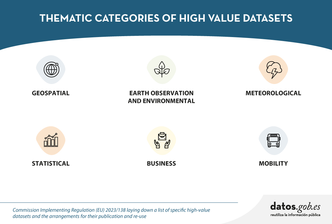
This article focuses on the geospatial category, called High-Value Geospatial Datasets (HVDG).
For all HVDGs, the following shall apply Directive 2007/2/EC of the European Parliament and of the Council of 14 March 2007 establishing an infrastructure for spatial information in the European Community (INSPIRE) with the exception of agricultural and reference parcels, for which Regulation (EU) 2021/211/EEC applies Regulation (EU) No 2021/2116 of the European Parliament and of the Council of 2 December 2021.
As reflected in the table below, the regulation provides detailed information on the requirements to be considered for these HVDGs, such as scales or granularity and attributes of each dataset. These are complementary to the attributes defined in the European Regulation (No 1089/2010), which establishes the interoperability of spatial data sets and services.
| Datasets | Scales | Attributes |
|---|---|---|
| Administrative units |
Levels of generalisation available with a granularity down to the scale of 1:5 000. From municipalities to countries; maritime units. |
|
| Geographical names |
Not applicable. |
|
| Directorates | Not applicable. |
|
| Buildings | Levels of generalisation available with a granularity up to the scale of 1:5 000 |
|
| Cadastral parcels | Levels of generalisation available with a granularity up to the scale of 1:5 000 |
|
| Reference areas | Levels of generalisation available with a granularity up to the scale of 1:5 000 |
|
| Agricultural areas | Level of accuracy equivalent to 1:10 000 scale and from 2016, 1:5 000 scale |
|
To ensure the accessibility and re-use of all these valuable datasets, it is imperative to follow certain provisions to facilitate their publication. Here are the key requirements:
- Open Licence: All datasets must be made available for re-use under a licence Creative Commons BY 4.0 or any equivalent less restrictive open licence. This encourages the freedom to share and adapt information.
- Open and Machine Readable Format: Data should be presented in an open, machine-readable format and be publicly documented. This ensures that the information is easily understandable and accessible to any person or automated system.
- Application Programming Interfaces (APIs) and Mass Download: Application programming interfaces (APIs) should be provided to facilitate programmatic access to data. In addition, direct bulk downloading of datasets should be possible, allowing flexible options for users according to their needs.
- Updated version: The availability of datasets in their most up-to-date version is essential. This ensures that users have access to the latest information, promoting the relevance and accuracy of data.
- Metadata: The description of the data will also be carefully taken care of through the use of metadata. This metadata shall, as a minimum, include the elements as defined in Commission Regulation (EC) No 1205/2008 of 3 December 2008. This regulation implements Directive 2007/2/EC of the European Parliament and of the Council and sets standards for metadata associated with datasets. The use of standardised metadata provides additional information essential for understanding, interpreting and using datasets effectively. By following these standards, interoperability and consistency in reporting is facilitated, thus promoting a more complete and accurate understanding of the available data.
These provisions not only promote transparency and openness, but also facilitate collaboration and the effective use of information in a variety of contexts.
Does Spain comply with the Geospatial HVD Regulation?
The INSPIRE (Infrastructure for Spatial Information in Europe) Directive determines the general rules for the establishment of an Infrastructure for Spatial Information in the European Community based on the Infrastructures of the Member States. Adopted by the European Parliament and Council on 14 March 2007 (Directive 2007/2/EC), entered into force on 25 April 2007.
INSPIRE makes it easier to find, share and use spatial data from different countries and in each of the regions, with HVDs available in the the Commission's new catalogue of HVDs and in each of the catalogues of the Spatial Data Infrastructures of the Autonomous Communities, as well as in the Official INSPIRE Data and Services Catalogue of Spain. The information is available through an online platform whit data from different countries.
WARNING!: They are currently working on this Geoportal carrying out the tasks of data dump, therefore, there may be some temporal inconsistency with the data provided, which correspond to the Official Catalogue of INSPIRE Data and Services (CODSI).
In Spain, we can find the Law 14/2010 of 5 July 2010 on geographic information infrastructures and services in Spain (LISIGE), which transposes Directive 2007/2/EC INSPIRE. This law frames the work to make all national spatial data available and obliges the adaptation of national spatial data to the Technical Guides or Guidelines collected by the INSPIRE Directive, thus ensuring that these data are compatible and interoperable in a Community and cross-border context.
LISIGE applies to geographic data that meet these conditions:
- Refering to a geographical area of the national territory, the territorial sea, the contiguous zone, the continental shelf and the exclusive economic zone.
- Having been generated by or under the responsibility of public administrations.
- Being in electronic format.
- Their production and maintenance is the responsibility of a public sector administration or body.
- Being within the themes of Annexes I (Geographic Reference Information), II (Fundamental Thematic Data) or III (General Thematic Data) referred to in the aforementioned law
Furthermore, it is clarified that the geographic data and services regulated by the LISIGE will be available on the NSDI Geoportal and on the CODSI as well as in the rest of the catalogues of the Autonomous Communities. The National Geographic Institute (IGN) is responsible for its maintenance.
Thanks to the tireless efforts of the entire Spanish administration since the publication of LISIGE, Spain has achieved a remarkable milestone. It is currently available on the INSPIRE Geoportal a wide range of information classified as High Value Geospatial Data Set (HVDG) is now available on the INSPIRE Geoportal. This achievement reflects our country's continued commitment to transparency and access to high quality geospatial data.
As of January 2024 Spain has published in the INSPIRE Geoportal and in CODSI the following information related to the High Geospatial Value Datasets (HVD)
- 31 datasets associated with their metadata
- 34 download services (WFS, ATOM Feed, OGC Api Feature)
- 28 visualisation services (WMS, WMTS)
Analysing the sets of high geospatial value we see that, according to the thematics, they have already been published:
| HVDG Spain | Datasets | Download services | Visualisation services | Covers Spanish territory |
|---|---|---|---|---|
| Administrative units |
5 | 7 | 7 | Sí |
| Geographical names |
7 | 8 | 8 | Sí |
| Directorates | 6 | 5 | 7 | Sí |
| Buildings | 5 | 3 | 4 | Sí |
| Cadastral parcels | 3 | 3 | 3 | Sí |
| Reference areas | 3 | 0 | 3 | Sí |
| Agricultural areas | 2 | 2 | 2 | Sí |
Spain currently complies with the HVDG Regulation in all categories. Specifically, it complies with the established legislation at the level of scale or granularity, attributes, license, format, availability of the data in API or maximum download, with being the most updated version and with the metadata.
A detailed analysis of the datasets published under the HVD framework highlights several key issues:
- Comprehensive Geographic Coverage: At least one dataset covering the whole of Spain has been made available.
- Comprehensive Metadata: Metadata has been generated for all High Geospatial Value Datasets (HVDGs). These metadata are published in the Official INSPIRE Catalogue of INSPIRE Data and Services (CODSI), validated to comply with the standards of the Commission Regulation (EC) No 1205/2008.
- Viewing and Downloading Services: All HVDGs have viewing and download services. Download services can be bulk download or download APIs. Currently, they are WFS and ATOM. In the future may be OGC API Feature or API Coverage.
- Open Licences and Open Formats: All published services are licensed under Creative Commons BY 4.0, and download services use standard and open formats such as the GML format documented by the international standard ISO 19136.
- Compliance with INSPIRE Data Models: Almost all datasets comply with the INSPIRE data models, thus ensuring the consistency and quality of the attributes set out in the HVDG regulation.
- Data Updated and Maintained: Download services guarantee the availability of data in the most up-to-date version. Each public administration responsible for the data is responsible for maintaining and updating the information.
This analysis highlights the commitment and efficiency in the management of geospatial data in Spain, contributing to the transparency, accessibility and quality of the information provided to the community.
It should be noted that, in Spain, all HVDG requirements are met. Organisations such as the CNIG and the ICGC or the Government of Navarre, in addition to publishing through WFS or ATOM services, are already working on publishing these datasets with the APIs of OGC.
The INSPIRE Geoportal has become a valuable source of information, thanks to the dedication and collaboration of various governmental entities, including Spanish ones. This breakthrough not only highlights progress in the implementation of geospatial standards, but also strengthens the basis for sustainable development and informed decision-making in Spain. A significant achievement for the country in the geospatial field!
Content prepared by Mayte Toscano, Senior Consultant in Data Economy Technologies. The contents and points of view reflected in this publication are the sole responsibility of its author.


Comments