Description
A spatial data or geographical data is that which has a geographical reference associated with it, either directly, through coordinates, or indirectly, such as a postal code. Thanks to these geographical references it is possible to locate its exact location on a map. The European Union includes spatial data among the datasets that can be considered of high value, due to their "considerable benefits for society, the environment and the economy, in particular due to their suitability for the creation of value-added services, applications and new jobs". There are many examples of the potential for re-use of this type of data. For example, the data provided by the Copernicus Earth Observation system has been used to create tools for monitoring areas susceptible to fire or to help stop drug trafficking. It is therefore important that spatial data is created in a way that facilitates its availability, access, interoperability and application.
A large amount of the open data managed by public administrations can be geo-referenced, thus maximising its value. To help public administrations publish this type of information in open format, this "Practical Guide to the Publication of Spatial Data" has been produced within the framework of the Aporta Initiative. It has been developed by Carlos de la Fuente García, an expert in open data, with the collaboration of the National Centre for Geographic Information (National Geographic Institute), as well as contributions and suggestions from a large number of experts in the field.
Who is the guide for?
The guide is primarily aimed at Open Data developers whose goal is to publish spatial data sets. It is preferable that the reader be familiar with basic knowledge about the fundamental elements that make up geospatial information, spatial context metadata and geographic web services.
What can I find in the guide?
The guide begins with a section that addresses the essential concepts needed to understand the nature of spatial data. This section includes explanations of the visual representation of geographic information, as well as details of the tools required for spatial data analysis and transformation, and the recommended formats and metadata. There are specific sections on Geographic Information Systems (GIS) and the role of geographic web services and Spatial Data Infrastructures (SDIs) in facilitating access to and management of geographic data sets and services is discussed.
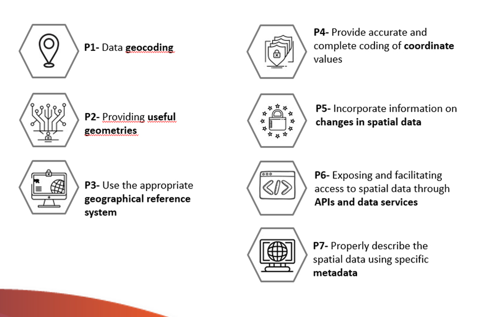
It then compiles a set of guidelines to facilitate the efficient publication of spatial data on the Internet, taking into account the international standards of the International Organization for Standardization (ISO). The guidelines detailed in this guide are:
Finally, a series of references, specifications, formats, standards and tools of direct application for the publication of Spatial Data are included.
The following elements are also included throughout the guide: references to the European INSPIRE Directive as a catalyst for sharing geographic resources in Europe and guidelines for describing spatial information derived from the Open Data metadata standards, DCAT and GeoDCAT-AP.
Other materials of interest
Although the primary scope of this document is oriented towards the publication of spatial data, it should not be forgotten that the application of all good practices linked to data quality in general is essential for their effective re-use. In this sense, it is advisable to complement this guide with the reading and application of other guides that provide guidance on the application of guidelines to ensure the publication of structured quality data, such as the Practical Guide for the publication of tabular data in CSV files and or using APIs.
You can download the Practical Guide for the Publication of Spatial Data from the following links:
Documentation
| Practical guide for the publication of Spatial Data (Spanish) | 4.80 MB |
|
|
| Cheat sheet (Spanish) | 434.51 KB |
|
|
| Cheat sheet (Spanish) | 359.59 KB | PPTX |
|
Buenos días,
os felicito por la publicación de este documento, trabajo en el sector público en información geográfica y son necesarias iniciativas de este tipo para promover las buenas prácticas y el conocimiento, y tener en cuenta cada vez más el dónde en los datos públicos y oficiales. Entiendo que esta documentación va dirigida sobre todo al sector público y por lo tanto echo en falta un apartado de contexto más claro y completo, habéis incluido un contexto técnico únicamente aunque luego de habla de INSPIRE-LISIGE. El contexto de la Información geográfica (IG) se dispone a todos los niveles, internacional, europeo y nacional. A nivel internacional se está haciendo un esfuerzo muy grande ya desde hace algunos años, en donde España participa activamente en naciones unidas, en UN-GGIM, donde se han acordado conjuntos de datos fundamentales y su estructura básica (que llamáis formato de datos, aunque debería ser modelo de datos), por lo tanto cualquier organismo que se encargue de desarrollar datos enmarcados como fundamentales deberían estar alienados con las directrices de UN-GGIM. En relación a esto, es importante mencionar en nuestro contexto la Información Geográfica de Referencia (IGR) tal y como se desarrolla en INSPIRE y en la LISIGE, ya que son datos oficiales para que cualquiera pueda referenciar sus datos (mediante la reutilización), esto va ligado a los conjuntos de datos espaciales fundamentales de UN-GGIM.
un saludo
Estimado:
Agradecemos esta aportación que sin duda contribuye a enriquecer el contenido de la guía. Por cuestiones de extensión y con el afán de facilitar la comprensión de los conceptos recogidos en la guía, se han quedado fuera o se indican muy conceptualmente algunos contenidos relevantes para comprender el contexto de la información geográfica en toda su extensión. El objetivo principal de esta guía es orientar sobre la publicación de datos abiertos espaciales y contribuir con ello a la necesidad de fomentar el desarrollo global de la información geoespacial tal como promueve UN-GGIM.
un saludo cordial,
datos.gob.es
Un saludo,
Como profesora universitaria que imparte docencia en el Grado de Ingeniería Geomática me ha alegrado y mucho la publicación del documento 'Guía práctica para la publicación de Datos Espaciales' . Creo que es un documento muy interesante para el estudiantado, sin embargo creo que hay un par de errores en la página 9 .
Primero:
Una proyección equidistante no mantiene las distancias. Si esto fuera cierto, también mantendría los ángulos y las áreas.
Las proyecciones equidistantes mantienen las distancias a lo largo de los meridianos.
Este error se está propagando de forma vertiginosa. Lo he visto publicado en atlas escolares, en la wikipedia y en documentos publicados por el IGN.
Segundo:
Las proyecciones afilácticas y modificadas son dos conceptos diferentes.
Si bien es cierto que las proyecciones afilácticas no mantienen ñangulos, áreas ni didtancias, no es cierto que todas generen deformaciones mínimas.
Las proyecciones modificadas o analíticas son aquellas que han sido modificadas analíticamente, a partir de otra proyección , para conseguir alguna propiedad como la conformidad, la equivalencia o la equidistancia. Por ejemplo, la proyección UTM es modificada y es conforme.
Agradecería mucho que modificaran el documento, pues me veo incapaz de recomendarselo a mis estudiantes.
¡Muchas gracias!
Muchas gracias por la aportación. En esta guía se han incluido conceptos muy generales en algunos apartados porque el objetivo principal es aportar conocimiento sobre la forma adecuada para publicar datos abiertos espaciales en catálogos como datos.gob.es y cualquier otro portal de datos abiertos. En cualquier caso, es importante ser precisos en la información que se aporta en la guía, por tanto procederemos a modificar ese punto próximamente.
¡Muchísimas gracias!