Evento
Geospatial data users have a new appointment to make in their diaries. The Copernicus Hackathon Malaga will take place from 18 September to 2 October 2020, virtually.
What is Copernicus Hackathon Málaga?
The Copernicus Hackathons are events for creating innovative digital applications and finding solutions to real world challenges, using data from Copernicus and Galileo, European Earth Observation and GPS positioning programmes, respectively. They focus on the organisation of several work teams to jointly develop new concepts and innovate in the use of existing data with practical applications for citizens and businesses.
In the specific case of Copernicus Hackathon Málaga, the thematic focus is on the current challenges of this city. Malaga and its metropolitan area represent a clear example to follow of Smart City applications, which combine green solutions to address the effects of the climate crisis. This is why it has recently been recognised as 2020 European Capital of Smart Tourism. As a coastal city, one of its main lines of action is sustainable blue growth. In this sense, applications based on Copernicus can be useful tools for improving urban management, business opportunities and citizen involvement.
Copernicus Hackathon Málaga will focus on developing digital content solutions, with particular attention to the climate crisis and its effects on society, the economy and the environment in the Mediterranean, and through three specific challenges:
- Digital content for Green and Smart Cities
- Digital Content for Sustainable and Intelligent Tourism
- Digital Content for Sustainable Blue Growth
The results of the Hackathon will serve a wide audience of users at the level of public administration, businesses and citizens.
It is worth noting that a new edition of Databeers Málaga will take place within the framework of this event, you can find more information about it in this article.
Who is it aimed at?
The event will bring together developers, entrepreneurs and experts with the aim of creating new applications based on data and services from Copernicus, the European Earth Observation Programme.
Participants will have the opportunity to work with thematic experts in remote sensing and entrepreneurship to develop a practical programming experience that responds to societal challenges such as the climate crisis and sustainable development through the innovative use of new technologies.
What does the winning team get?
The presentation and award ceremony will take place on the 2nd of October at the National Digital Content Pole of Malaga City Council l.
The winning team will have access to the Copernicus Accelerator Programme, a 12-month accompaniment programme for young entrepreneurs that includes coaching, boot camps, online training and access to networks. The collaborators of the Malaga edition will offer other prizes, including a place in the co-working space of the DigitaPolo l and mentoring for 6 months.
What do you have to do to participate?
In order to participate it is necessary to fill in the registration form on the event's website: copernicus.adabyron.uma.es, where you can also find more information about this event.
The registration period is open until 10 September.
Who is organising it?
Copernicus Hackathon Málaga is organised by the European Topic Centre of the University of Málaga (ETC-UMA), together with the Strategic Chair of Geotechnological Resources for Economy and Society, and is part of the Copernicus Hackathon Programme, funded by the European Commission.
The event also has the collaboration of the National Digital Content Pole of Malaga City Council, the companies Randbee Consultants, Cartometrics and GMV, as well as the support of Climate-KIC, SpaceTec Partners and the European Association of Remote Sensing Companies (EARSC).
Blog
COPERNICUS, the Earth observation program of the European Union, is the world's largest geospatial data provider, with a current production of twelve terabytes a day. The possible uses of this data, many of which are made available to citizens for free, are multiple and can have a place in various economic sectors: from promoting political decision-making to improve sustainability or emergency management to optimize transport or agricultural management. Its economic potential is therefore immense. But starting a business that uses this kind of data is not always easy.
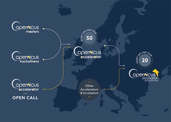
In this context, COPERNICUS START-UP PROGRAMME was born, to help entrepreneurs and new companies to promote new businesses based on the data offered by the Copernicus project. The program consists of four components: prizes, hackathons, acceleration program and incubation program.
- The Copernicus Prizes support the generation of new applications and business ideas. Aimed at entrepreneurs, start-ups and students, they are awarded in the context of the Copernicus Master project. In 2019, participants have had the opportunity to win prizes with a total value of more than 450,000 euros and additional benefits such as coaching, technical support or marketing assistance. To do this, they had to solve a series of challenges posed by partners such as Airbus, the European Space Agency (ESA) or the German Ministry of Transport.
- Copernicus Hackathons are events in which programmers and subject-matter experts collaborate to develop software solutions based on Copernicus data and services that solve global social and economic problems. In this regard, the European Commission funds 20 Copernicus hackatons every year throughout Europe, which can be organized by any organization that is running for it.
- Copernicus Accelerator is a 12-month acceleration program that welcomes 50 new entrepreneurs every year in the European territory. During the program, each participant has the help of a mentor who offers a personalized guide to achieve a commercial objective (for example, participate in an incubator programme or obtaining a first client). The program begins and closes with two BootCamps, where all participants meet their mentor and can expand their contacts network. In addition, participants have at their disposal a virtual training program with new online courses every month.
- Copernicus Incubator is the incubation program for start-ups that are less than 5 years old. Each year, the program grants 50,000 euros to 20 European companies, to finance its consolidation. In 2020, three new rounds of financing will take place in February, May and October.
To these programs we must add other initiatives such as Copernicus Relay and Copernicus Academy. Copernicus Relay is a program made up of organizations that coordinate and promote local activities around the Copernicus program, while Copernicus Academy connects European universities, research institutions, business schools and private organizations from the countries participating in the program, facilitating collaboration between them. You can read more about both programs and the role of Spain in them in this article.
In short, thanks to all these activities, the development of innovative applications and products increase to make the lives of European citizens and other places in the world easier. In the use cases section of the Copernicus website you can see some of the projects carried out based on the information provided by the program, which can inspire you to dare to innovate with the geospatial data provided by Copernicus.
Blog
Geospatial data is one of the data categories most demanded by organizations, companies and citizens. The new European regulation on open data and reuse of public sector information considers them as high-value data, due to its ability to boost innovative services and generate socio-economic benefits in multiple sectors of activity.
When we talk about geospatial data, one of the main sources of data that comes to mind is COPERNICUS, the Earth observation program of the European Union.This program is led by the European Commission, with the collaboration of member states and various European agencies and organizations, such as the European Space Agency (ESA) and the European Environment Agency (EEA).
What is the Copernicus program?
Under the slogan “Europe's eye on Earth for the ultimate benefit of European citizens”, Copernicus collects, stores, combines and analyzes data obtained through two sources:
- Data obtained from satellite observation, through the constellations of Sentinel satellites and other third-party satellites.
- Data obtained by land, air and maritime in-siue sensor systems.
These data are organized through 6 servicesthat facilitate access to data and information: emergency, security, marine, land, climate change and atmosphere.

Based on these services, Copernicus has become the largest geospatial data provider in the world, with a current production of twelve terabytes per day. Most of these data - with the exception of those that may compromise citizen security - are provided free of charge and full through the DIAS services (cloud platforms that provide centralized access to Copernicus data and information) or through conventional data platforms.
This information is essential for decision-making in the new electronic government and digital economy systems, covering areas such as management and monitoring of sustainability, climate change and environment, transport, urban agenda and smart cities, security, emergency and catastrophe management, agriculture, energy and natural resources or blue economy, among many others. These data can also be combined with the data obtained through the GALILEO program,the European radionavigation and satellite positioning system. In this way, new opportunities for the public and private sector can be generated, while working towards the achievement of sustainable development goals.
The role of the Ministry of Development in the Copernicus Program
The Ministry of Development participates in the European Earth Observation Program COPERNICUS,as a national representative in various committees and forums, in addition to actively contributing to the provision of free and open data and services. Among others, it collaborates with the territory and marine services, through the D.G. of the National Geographic Institute (IGN) and State Ports.
Specifically, the IGN Territory Observation Unit exercises national representation, together with the Ministry for Ecological Transition (MITECO), in the Copernicus User Forum, for the monitoring and evolution of the program according to user requirements. The User Forum is the working group created to assist the Copernicus Committee to determine user requirements, verify service compliance and coordinate users in public sector. In turn, the Copernicus Committee in Spain is constituted by the Ministry of Industry, Commerce and Tourism and the Centre for Technological and Industrial Development (CDTI).
The IGN is also responsible for the national coordination of the Copernicus (Land) Service and the In Situ; Component; leads the European group of experts Copernicus In Situ EIONET Expert Group; and participates in the Copernicus Coordination Action Framework Program as a National Land Use Reference Center for the 2017-2021 period and the Copernicus User uPtake Framework Program (FP-CUP): 2018/2020.
In addition, it collaborates in the dissemination activities of the Copernicus Program in our country, such as Copernicus Relay and Academy.
Copernicus Relay y Academy
One of the purposes of the Copernicus program is to boost the economic opportunities of geospatial data. Through awards, hackathons, accelerators, e incubators, Copernicus want to help companies develop innovative ideas based on the reuse of the data they provide.
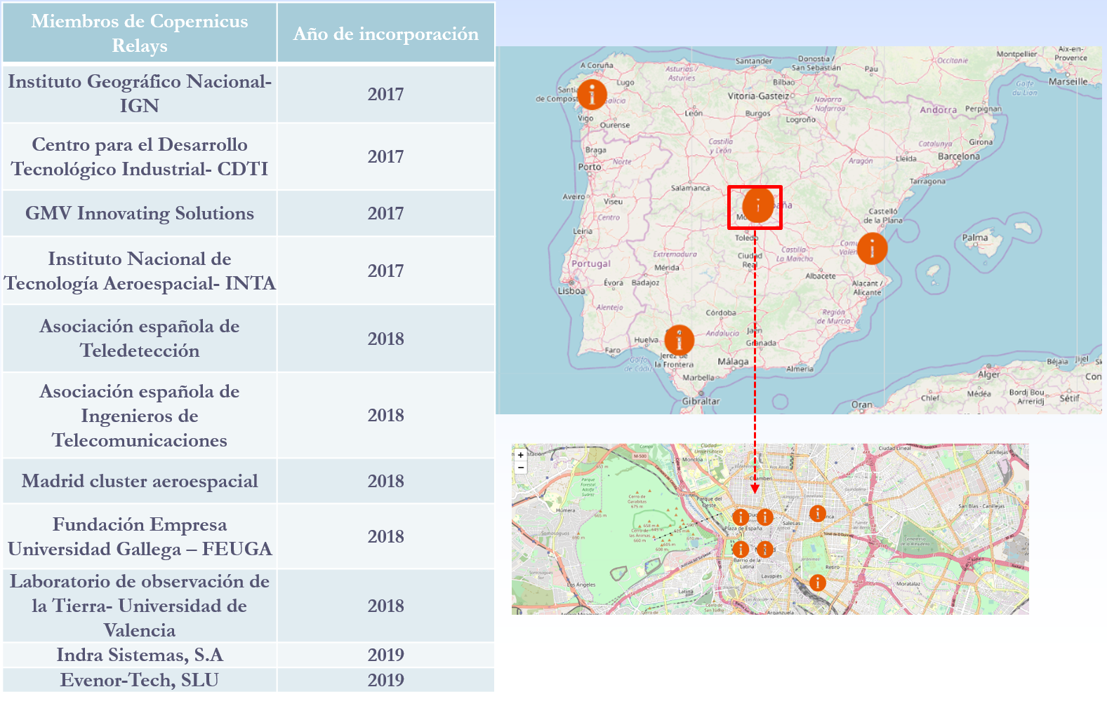
In addition, a set of networks called Copernicus Relay and Academy. were created in the first quarter of 2017to ensure some of the needs that the Copernicus program requires.
- Copernicus Relay
The Copernicus Relay are a group of organizations that coordinate and promote activities around the Copernicus program for local users and administrations in the field of Territory Observation. Its objective is to make known in Europe and outside Europe that Copernicus is a sustainable source of full, free and open information that meets the needs of national, regional and local public services, and that can function as a reinforcement for the development of services.
There are currently a total of 85 European Relay members of which 11 are Spanish. The IGN has been a member of Copernicus Relay since 2017.
The possible actions that can be developed by Copernicus Relay members are, among others:
- Coordinate activities at the local level
- Distribute Copernicus dissemination material.
- Inform about what Copernicus is and answer user questions.
- Perform and promote events to publicize Copernicus.
- Organize courses
Any organization that is well connected with user communities, such as private companies, research centers, universities and end users of the public or private sector, can participate. To be a member of Copernicus Relay it is necessary to make a request on this website.
- Copernicus Academy
The Copernicus Academy connect European universities, research institutions, business schools and private organizations of the countries participating in the program and beyond. The objective of the network is to link academic and research institutions with authorities and service providers, facilitating collaborative research and the development of conferences, training sessions and internships. It also provides educational and training material for researchers, scientists and entrepreneurs.
Copernicus Academy also works to increase ideas and good practices sharing across borders and disciplines, while contributing to the development of the use of Earth Observation data in general and Copernicus data and information in particular, in various organizations or industries of public or private users.
There are currently a total of 17 Academy members in Spain.
In short, through these and other initiatives it is expected that an increasing number of users will know the Copernicus program and boost the economic and social opportunities that it entails. Thanks to the accurate, up-to-date and easy-to-access information of the Copernicus program, we will be able to know our environment better, and make decisions that guarantee the future of all European and other regions citizens.
Content prepared based on information by Nuria Valcárcel, Deputy Assistant Director, D.G. National Geographic Institute. Ministry of development.
Entrevista
Copernicus is the Earth observation program of the European Union. Through 6 thematic services, and the images provided by its satellites, Copernicus provides complete, free and up-to-date geospatial data that helps the monitoring and management of the territory and the planet both at European and worldwide level.
In datos.gob.es, we have interviewed Nuria Valcárcel, Deputy Assistant Director (Observation of the Territory) of the General Directorate of Geodesy and Cartography, in the D.G. National Geographic Institute (IGN) of the Ministry of Development, an organization that represents Spain in the Copernicus Users Forum, for the monitoring and evolution of the program, together with the Ministry for Ecological Transition (MITECO).
Earth observation data, such as those linked to the Copernicus project, always awaken great interest. What are the reasons?
Copernicus geospatial data are essential as a decision-making tool in the current digital economy and government systems. These data can be used to analyze and monitor phenomena due to climate change, and help us find solutions. Its potential is also enormous in matters related to safety, transportation, emergency management, sustainability assessment...
There are many organizations that, aware of the current context, have highlighted the importance of this initiative to achieve the Sustainable Development Goals (SDGs), such as the United Nations Organization or the European Commission. The United Nations, in its document “Transforming our world: the 2030 Agenda for Sustainable Development”, indicates that national institutions should promote the use of Earth observation data and geospatial information, to follow up on the 2030 Agenda.
Specifically, what kind of data and information does Copernicus provide?
Copernicus data has 2 large components: on the one hand, the information obtained via satellite, such as the Sentinel constellations, and on the other the in-situ component, that is, any data not coming from satellites. For example, air quality data, water quality data in rivers and reservoirs, wave and sea level information through buoys, tide gauges, orthophotographs and digital elevation models ... In the case of Spain, these data are provided by different national organizations such as IGN, MITECO, AEMET or State Ports, among others.
Through the Copernicus hub you can access and download these data. The information obtained through Sentinel satellites is available for use by any citizen, but when we talk about the rest of the on-site data, we find differences according to the data policy of each country. In the case of Spain, it should be noted that we have really been pioneers in open data policies and much of the information we generate is available through Copernicus' own download platforms or national platforms.
Who are the main users of this type of data? Could you give an example?
Public administrations are the main users of Copernicus, but an increasing number of companies rely on these data to generate new opportunities and improve their competitiveness, as well as universities and research centers.
The IGN and other Spanish administrations are beginning to work with large and small Spanish companies to collaborate in the generation of data for Copernicus, but we also try to boost its reuse more and more. For example, for water management or smart agriculture, since they facilitate continuous monitoring of the state of the crops, allowing water resources to be optimized. As a concrete example, we can talk about the DIANA Project, in which the company AGRISAT and the Andalusian Federation of Irrigation Communities of Andalusia (FERAGUA) participate, to generate an innovative commercial services platform, based on Copernicus Earth Observation data and other sources, for the identification of illegal irrigation areas and the estimation of volumes of water extracted.
Forest management can also greatly benefit from Sentinel satellites and Copernicus data. This is the case of AGRESTA and its FORESMAP application, which combine satellite data with others data sources such as the Lidar provided by the IGN, to provide an online forest inventory calculation. This application has been awarded at the 2018 Copernicus Masters CGI Big Data Business Challenge.
Another area with great potential is marine services, for the sustainable exploitation of coastal resources, port management, or the optimization and safety of trade routes. Here we can mention NOLOGIN as an example. It provide a (web and mobile) real time application and predictions for decision making in system ports, based on Copernicus data, with an alert and report management interface.
And regarding public administrations, do you know any AA.PP. that intensively use Copernicus project data?
There are many experiences. To highlight some examples, the IGN provides Copernicus data directly through the Download Center and makes extensive use and dissemination of Sentinel satellite images through the National Remote Sensing Plan. These data are also used by the IGN to enrich the system for monitoring changes in the terrain, for example, to assess volcanic risk.
The data of the marine operational service are very useful for State Ports. knowing how marine currents evolve, and improving their predictive models is possible thanks to them
For its part, AEMET participates in the generation of Copernicus data and services in relation to Atmosphere and Climate Change, as a member of the European Centre for Medium-Range Weather Forecasts, which benefits Spanish institutions and scientists participating in numerous research programs.
The Spanish Agricultural Guarantee Fund, the National Parks Network, the General Water Directorate, the Autonomous Communities, as well as a large number of universities and study centers also use these type of data.
What are the main challenges and barriers to the reuse of Earth observation data?
The challenges that reusers have to face could be summarized in 4 areas.
In the first place, some technical knowledge is required to work with Copernicus data. Although sometimes we find some data or services easy to use by non-expert users, in other cases advanced capabilities are needed to locate and understand the information. Copernicus Program is making an effort to train professionals, through free courses, while working on the creation of environments where data are easily located and easy to use.
Secondly, we could talk about the coordination between the different levels of European administration (local, regional, state ...). A common effort must be made to generate better data, avoiding duplication, and for this, coordination between European and national institutions is essential. Currently, there are coordination mechanisms already established, but there are areas for improvement.
Thirdly, it is necessary to improve the interaction with users, to better understand their needs and thus be able to assess whether the Copernicus program is responding to those needs. And these needs are changing and require constant adaptation. Through the Spanish Users' Committees and Forum, the National Services Coordinators, and the Relay and Academy Networks, we are making a strong effort to approach as many users as possible, to work together in a common goal.
Finally, we cannot forget the need to encourage data to be interoperable, to meet common standards and to be harmonized. For example, the Mediterranean coast, and the different phenomena and dynamics that affect it, have to be monitored as a whole, and for this we need a common pan-European data, also harmonized with the national data that each country manages. Again, coordination between administrations is essential to achieve this goal.
One of the challenges you have mentioned is the user´s lack of knowledge about Copernicus data availability. What concrete actions are the IGN taking to publicize Copernicus data?
The European Union organizes different activities to encourage the use of Copernicus data in private companies. This is the case of the Copernicus Master competition, hackathons, the acceleration programs (Copernicus Accelerator) or business incubation (Copernicus Incubator). These types of activities, often aimed at entrepreneurs and start-ups, seek to support new ideas that involve the creation of services and commercial applications related to Copernicus.
In addition, the IGN, together with the Ministry for Ecological Transition (MITECO), in the Copernicus Users Forum, and also with representatives in the Copernicus Committee (the Ministry of Industry, Commerce and Tourism and the Centre for Technological and Industrial Development), works very actively with the different user groups in Spain. We are part of the Copernicus Users Forum, we carry out meetings and workshops for specific services and themes (Territory, Marine, Agriculture, Smart Cities, etc.), we encourage the participation of universities in Copernicus activities and proposals… In short, we seeks to generate a favorable ecosystem that facilitates the use of Copernicus.
Finally, could you tell us what your future plans are?
The Copernicus program is open to continuous review of requirements. In this regard, I would highlight two issues on the agenda.
First, the synergies between Copernicus and Galileo, the European Union navigation system, that the Ministry of Development also lead in Spain. The integration of both systems allows real-time monitoring of atmospheric phenomena to determine how vehicles move in cities. In this way, the constant impact of greenhouse gas emissions from vehicles could be monitored. It could also be used in matters of security, surveillance of natural hazards, etc.
On the other hand, the European Commission is directing its policies towards sustainability and the fight against climate change. In the new Copernicus operating cycle (2021-2027), some of the areas to be promoted are the monitoring of greenhouse gases or the monitoring of Polar Regions (snow and ice level). The civil security approach will also be expanded and the use of Copernicus data will be encouraged not only in Europe, but also in other regions, such as Latin America or Africa.
Noticia
The environment is a concern and a matter of general interest for our society. We should not be surprised, therefore, by the numerous initiatives within the universe of open data for the publication of information related to the environment, both internationally and locally. These initiatives cover different aspects of the environment within the competences assigned to government bodies and agencies: natural resource management, biodiversity, air quality, climate and atmospheric information, and many more.
As environmental topics are very diverse, the typology and nature of the data can also be diverse. It is not easy a priori to find homogeneous universal criteria to describe the wide variety of information related to the description of the environment (for example, ranging from the population of a subspecies of cod near Iceland to levels of solar irradiance in an area of Extremadura). Therefore, for clarity, a separation is established between "data on the environment" (any information describing some aspect of the environment in a general sense) and "environmental data" (the second being a subset of the first)
Expressed intuitively, environmental data consists of measurements of physical and chemical magnitudes, usually obtained using specific instrumentation, such as sensors or measuring equipment. In general, this data describes observations (or measurements) whose value must be related at least to the following information:
- Description of the nature of the physical magnitude.
- Spatial and/or geographical dimension.
- Time dimension.
- Unit of measurement.
- Description of the instrumentation.
As regards existing vocabularies for the description of "environmental data", the Semantic Sensor Network Ontology (currently still at draft stage) should be noted. This vocabulary is a joint effort between the W3C Consortium and the Open Geospatial Consortium (OGC). Also worth noting is the possibility of applying the RDF Data Cube vocabulary, although perhaps its use cannot be generalized in all cases.
At European level, the European Environment Agency (EEA) provides a very comprehensive catalogue of data in direct collaboration with Member States and other initiatives such as the Copernicus programme. This program is managed inter alia by the European Space Agency ESA) and the European Organization for the Exploitation of Meteorological Satellites (EUMETSAT). This programme, on the one hand, captures environmental data via satellites and sensor systems that measure physical, maritime, climatic and atmospheric physical magnitudes and, on the other hand, provides this information through free and open services for the general public and European companies.
In the last edition of the international open data conference: IODC 16 (International Open Data Conference) held in Madrid last October, the environment was one of the central issues, with a slot specifically dedicated to discussing advances and opportunities for the use of open data for understanding the climate globally, biodiversity resource management and other related issues. This is an unequivocal sign that the environment has acquired strategic relevance in international agendas for the opening up of data.