Blog
The value of open satellite data in Europe
Satellites have become essential tools for understanding the planet and managing resources efficiently. The European Union (EU) has developed an advanced space infrastructure with the aim of providing real-time data on the environment, navigation and meteorology.
This satellite network is driven by four key programmes:.
- Copernicus: Earth observation, environmental monitoring and climate change.
- Galileo: high-precision satellite navigation, alternative to GPS.
- EGNOS: improved positioning accuracy, key to aviation and navigation.
- Meteosat: padvanced meteorological prediction and atmospheric monitoring.
Through these programmes, Europe not only ensures its technological independence, but also obtains data that is made available to citizens to drive strategic applications in agriculture, security, disaster management and urban planning.
In this article we will explore each programme, its satellites and their impact on society, including Spain''s role in each of them.
Copernicus: Europe''s Earth observation network
Copernicus is the EU Earth observation programme, managed by the European Commission with the technical support of the European Space Agency (ESA) and the European Organisation for the Exploitation of Meteorological Satellites (EUMETSAT).. It aims to provide free and open data about the planet to monitor climate change, manage natural resources and respond to emergencies.
The programme is structured into three main components:
- Space component: consists of a series of satellites called Sentinel, developed specifically for the needs of Copernicus. These satellites provide high quality data for various applications, such as land, sea and atmospheric monitoring.
- Component in situ: includes data collected through ground, air and sea stations. These data are essential to calibrate and validate the information obtained by the satellites, ensuring its accuracy and reliability.
- Operational Services: offers six thematic services that transform collected data into useful information for users:
- Atmospheric monitoring
- Marine monitoring
- Terrestrial monitoring
- Climate change
- Emergency management
- Safety
These services provide information in areas such as air quality, ocean status, land use, climate trends, disaster response and security, supporting informed decision-making in Europe.
Spain has played a key role in the manufacture of components for the Sentinel satellites. Spanish companies have developed critical structures and sensors, and have contributed to the development of data processing software. Spain is also leading projects such as the Atlantic Constellation, which will develop small satellites for climate and oceanic monitoring.
Sentinel satellite
| Satellite | Technical characteristics | Resolution | Coverage (capture frequency) | Uses |
|---|---|---|---|---|
| Sentinel-1 | C-band SAR radar, resolution up to 5m | Up to 5m | Every 6 days | Land and ocean monitoring, natural disasters |
| Sentinel-2 | Multispectral camera (13 bands), resolution up to 10m | 10m, 20m, 60m | Every 5 days | Agricultural management, forestry monitoring, water quality |
| Sentinel-3 | Radiometer SLSTR, Spectrometer OLCI, Altimeter SRAL | 300m (OLCI), 500m (SLSTR) | Every 1-2 days | Oceanic, climatic and terrestrial observation |
| Sentinel-5P | Tropomi spectrometer, resolution 7x3.5 km². | 7x3.5 km² | Daily global coverage | Air quality monitoring, trace gases |
| Sentinel-6 | Altimeter Poseidon-4, vertical resolution 1 cm | 1cm | Every 10 days | Sea level measurement, climate change |
Figure 1. Table satellites Sentinel. Source: own elaboration
Galileo: the european GPS
Galileo is the global navigation satellite system developed by the European Union, managed by the European Space Agency (ESA) and operated by the European Union Space Programme Agency (EUSPA). It aims to provide a reliable and highly accurate global positioning service, independent of other systems such as the US GPS, China''s Beidou or Russia''s GLONASS. Galileo is designed for civilian use and offers free and paid services for various sectors, including transport, telecommunications, energy and finance.
Spain has played a leading role in the Galileo programme. The European GNSS Service Centre (GSC), located in Torrejón de Ardoz, Madrid, acts as the main contact point for users of the Galileo system. In addition, Spanish industry has contributed to the development and manufacture of components for satellites and ground infrastructure, strengthening Spain''s position in the European aerospace sector.
| Satellite | Technical characteristics | Resolution | Coverage (capture frequency) | Uses |
|---|---|---|---|---|
| Galileo FOC | Medium Earth Orbit (MEO), 24 operatives | N/A | Continuous | Precise positioning, land and maritime navigation |
| Galileo IOV | First test satellites of the Galileo system | N/A | Continuous | Initial testing of Galileo before FOC |
Figure 2. Satellite Galileo. Source: own elaboration
EGNOS: improving the accuracy of GPS and Galileo
The European Geostationary Navigation Overlay Service (EGNOS) is the European satellite-based augmentation system (Satellite Based Augmentation System or SBAS) designed to improve the accuracy and reliability of global navigation satellite systems ( Global Navigation Satellite System, GNSS), such as GPS and, in the future, Galileo. EGNOS provides corrections and integrity data that allow users in Europe to determine their position with an accuracy of up to 1.5 metres, making it suitable for safety-critical applications such as aviation and maritime navigation.
Spain has played a leading role in the development and operation of EGNOS. Through ENAIRE, Spain hosts five RIMS Reference Stations located in Santiago, Palma, Malaga, Gran Canaria and La Palma. In addition, the Madrid Air Traffic Control Centre, located in Torrejón de Ardoz, hosts one of the EGNOS Mission Control Centres (MCC), operated by ENAIRE. The Spanish space industry has contributed significantly to the development of the system, with companies participating in studies for the next generation of EGNOS.
| Satellite | Technical characteristics | Resolution | Coverage (capture frequency) | Uses |
|---|---|---|---|---|
| EGNOS Geo | Geostationary GNSS correction satellites | N/A | Real-time GNSS correction | GNSS signal correction for aviation and transportation |
Figure 3. Table satellite EGNOS. Source: own elaboration
Meteosat: high precision weather forecasting
The Meteosat programme consists of a series of geostationary meteorological satellites initially developed by the European Space Agency (ESA) and currently operated by the European Organisation for the Exploitation of Meteorological Satellites (EUMETSAT). These satellites are positioned in geostationary orbit above the Earth''s equator, allowing continuous monitoring of weather conditions over Europe, Africa and the Atlantic Ocean. Its main function is to provide images and data to facilitate weather prediction and climate monitoring.
Spain has been an active participant in the Meteosat programme since its inception. Through the Agencia Estatal de Meteorología (AEMET), Spain contributes financially to EUMETSAT and participates in the programme''s decision-making and operations. In addition, the Spanish space industry has played a key role in the development of the Meteosat satellites. Spanish companies have been responsible for the design and supply of critical components for third-generation satellites, including scanning and calibration mechanisms.
| Satellite | Technical characteristics | Resolution | Cobertura (frecuencia de captura) | Usos |
|---|---|---|---|---|
| Meteosat Primera Gen. | Initial weather satellites, low resolution | Low resolution | Every 30min | Basic weather forecast, images every 30 min. |
| Meteosat Segunda Gen. | Higher spectral and temporal resolution, data every 15 min. | High resolution | Every 15min | Improved accuracy, early detection of weather events |
| Meteosat Tercera Gen. | High-precision weather imaging, lightning detection | High resolution | High frequency | High-precision weather imaging, lightning detection |
Figure 4. Metosat satellite. Source: own elaboration
Access to the data of each programme
Each programme has different conditions and distribution platforms in terms of access to data:
- Copernicus: provides free and open data through various platforms. Users can access satellite imagery and products through the Copernicus Data Space Ecosystem, which offers search, download and processing tools. Data can also be obtained through APIs for integration into automated systems.
- Galileo: its open service (Open Service - OS) allows free use of the navigation signals for any user with a compatible receiver, free of charge. However, direct access to raw satellite data is not provided. For information on services and documentation, access is via the European GNSS Services Centre (GSC):
- Galileo Portal.
- Registration for access to the High Accuracy Service (HAS) (registration required).
- EGNOS: This system improves navigation accuracy with GNSS correction signals. Data on service availability and status can be found on the EGNOS User Support platform..
- Meteosat: Meteosat satellite data are available through the EUMETSAT platform. There are different levels of access, including some free data and some subject to registration or payment. For imagery and meteorological products you can access the EUMETSAT Data Centre..
In terms of open access, Copernicus is the only programme that offers open and unrestricted data. In contrast, Galileo and EGNOS provide free services, but not access to raw satellite data, while Meteosat requires registration and in some cases payment for access to specific data.
Conclusions
The Copernicus, Galileo, EGNOS and Meteosat programmes not only reinforce Europe''s space sovereignty, but also ensure access to strategic data essential for the management of the planet. Through them, Europe can monitor climate change, optimise global navigation, improve the accuracy of its positioning systems and strengthen its weather predictioncapabilities, ensuring more effective responses to environmental crises and emergencies.
Spain plays a fundamental role in this space infrastructure, not only with its aerospace industry, but also with its control centres and reference stations, consolidating itself as a key player in the development and operation of these systems.
Satellite imagery and data have evolved from scientific tools to become essential resources for security, environmental management and sustainable growth. In a world increasingly dependent on real-time information, access to this data is critical for climate resilience, spatial planning, sustainable agriculture and ecosystem protection.
The future of Earth observation and satellite navigation is constantly evolving, and Europe, with its advanced space programmes, is positioning itself as a leader in the exploration, analysis and management of the planet from space.
Access to this data allows researchers, businesses and governments to make more informed and effective decisions. With these systems, Europe and Spain guarantee their technological independence and strengthen their leadership in the space sector.
Ready to explore more? Access the links for each programme and discover how this data can transform our world.
| Copernicus | https://dataspace.copernicus.eu/ | Download centre |
|---|---|---|
| Meteosat | https://user.eumetsat.int/data-access/data-centre/ | Download centre |
| Galileo | https://www.gsc-europa.eu/galileo/services/galileo-high-accuracy-servic…/ | Download centre, after registration |
| EGNOS | https://egnos-user-support.essp-sas.eu/ | Project |
Figure 5. Source: own elaboration
Content prepared by Mayte Toscano, Senior Consultant in Data Economy Technologies. The contents and points of view reflected in this publication are the sole responsibility of the author.
Blog
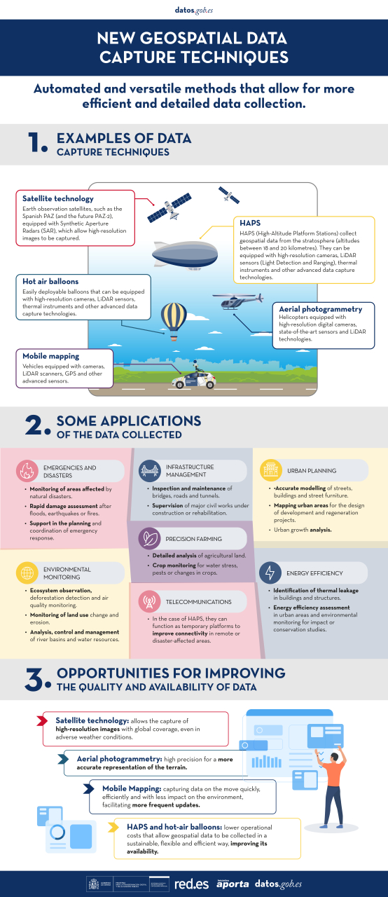
Geospatial data capture is essential for understanding our environment, making informed decisions and designing effective policies in areas such as urban planning, natural resource management or emergency response. In the past, this process was mainly manual and labour-intensive, based on ground measurements made with tools such as total stations and levels. Although these traditional techniques have evolved significantly and are still widely used, they have been complemented by automated and versatile methods that allow more efficient and detailed data collection.
The novelty in the current context lies not only in technological advances, which have improved the accuracy and efficiency of geospatial data collection, but also because it coincides with a widespread shift in mindset towards transparency and accessibility. This approach has encouraged the publication of the data obtained as open resources, facilitating their reuse in applications such as urban planning, energy management and environmental assessment. The combination of advanced technology and an increased awareness of the importance of information sharing marks a significant departure from traditional techniques.
In this article, we will explore some of the new methods of data capture, from photogrammetric flights with helicopters and drones, to ground-based systems such as mobile mapping, which use advanced sensors to generate highly accurate three-dimensional models and maps. In addition, we will learn how these technologies have empowered the generation of open data, democratising access to key geospatial information for innovation, sustainability and public-private collaboration.
Aerial photogrammetry: helicopters with advanced sensors
In the past, capturing geospatial data from the air involved long and complex processes. Analogue cameras mounted on aircraft generated aerial photographs that had to be processed manually to create two-dimensional maps. While this approach was innovative at the time, it also had limitations, such as lower resolution, long processing times and greater dependence on weather and daylight. However, technological advances have reduced these restrictions, even allowing operations at night or in adverse weather conditions.
Today, aerial photogrammetry has taken a qualitative leap forward thanks to the use of helicopters equipped with state-of-the-art sensors. The high-resolution digital cameras allow images to be captured at multiple angles, including oblique views that provide a more complete perspective of the terrain. In addition, the incorporation of thermal sensors and LiDAR (Light Detection and Ranging) technologies adds an unprecedented layer of detail and accuracy. These systems generate point clouds and three-dimensional models that can be integrated directly into geospatial analysis software, eliminating much of the manual processing.
| Features | Advantages | Disadvantages |
|---|---|---|
| Coverage and flexibility | It allows coverage of large areas and access to complex terrain. | May be limited for use in areas with airspace restrictions. Inaccessible to undergrouns or difficult to access areas such as tunnels. |
| Data type | Capture visual, thermal and topographic data in a single flight. | - |
| Precision | Generates point clouds and 3D models with high accuracy. | - |
| Efficiency in large projects | It allows coverage of large areas where drones do not have sufficient autonomy. | High operational cost compared to other technologies. |
|
Environmental impact and noise
|
- | Generates noise and greater environmental impact, limiting its use in sensitive areas. |
| Weather conditions | - | It depends on the weather; adverse conditions such as wind or rain affect its operation. |
| Amortised | - | High cost compared to drones or ground-based methods. |
Figure 1. Table with advantages and disadvantages of aerial photogrammetry with helicopters.
Mobile mapping: from backpacks to BIM integration
The mobile mapping is a geospatial data capture technique using vehicles equipped with cameras, LiDAR scanners, GPS and other advanced sensors. This technology allows detailed information to be collected as the vehicle moves, making it ideal for mapping urban areas, road networks and dynamic environments.
In the past, topographic surveys required stationary measurements, which meant traffic disruptions and considerable time to cover large areas. In contrast, mobile mapping has revolutionised this process, allowing data to be captured quickly, efficiently and with less impact on the environment. In addition, there are portable versions of this technology, such as backpacks with robotic scanners, which allow access to pedestrian or hard-to-reach areas.
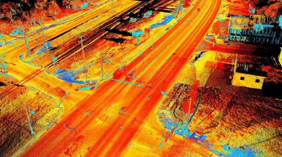
Figure 2. Image captured with mobile mapping techniques.
| Features | Advantages | Disadvantages |
|---|---|---|
| Speed | Captures data while the vehicle is on the move, reducing operating times. | Lower accuracy in areas with poor visibility for sensors (e.g. tunnels). |
| Urban coverage | Ideal for urban environments and complex road networks. | It is efficient in areas where vehicles can circulate, but its range is limited such as in rural or inaccessible terrain. |
| Flexibility of implementation | Available in portable (backpack) versions for pedestrian or hard-to-reach areas. | Portable equipment tends to have a shorter range than vehicular systems. |
| GIS and BIM implementation | It facilitates the generation of digital models and their use in planning and analysis. | Requires advanced software to process large volumes of data. |
| Impact on the environment | It does not require traffic interruptions or exclusive access to work areas. | Dependence on optimal environmental conditions, such as adequate light and climate. |
| Accessibility | Accessible to underground or hard-to-reach areas such as tunnels |
Figure 3. Table with advantages and disadvantages of mobile mopping.
The mobile mapping is presented as a versatile and efficient solution for capturing geospatial data on the move, becoming a key tool for the modernisation of urban and territorial management systems.
HAPS and ballons: new heights for information capture
HAPS (High-Altitude Platform Stations) and hot-air balloons represent an innovative and efficient alternative for capturing geospatial data from high altitudes. These platforms, located in the stratosphere or at controlled altitudes, combine features of drones and satellites, offering an intermediate solution that stands out for its versatility and sustainability:
- HAPS, like zeppelins and similar aircraft, operate in the stratosphere, at altitudes between 18 and 20 kilometres, allowing a wide and detailed view of the terrain.
- The aerostatic balloons, on the other hand, are ideal for local or temporary studies, thanks to their easiness of deployment and operation at lower altitudes.
Both technologies can be equipped with high-resolution cameras, LiDAR sensors, thermal instruments and other advanced technologies for data capture.
| Features | Advantages | Disadvantages |
|---|---|---|
| Useful | Large capture area, especially with HAPS in the stratosphere. | Limited coverage compared to satellites in orbit. |
| Sustainability | Lower environmental impact and energy footprint compared to helicopters or aeroplanes. | Dependence on weather conditions for deployment and stability. |
| Amortised | Lower operating costs than traditional satellites. | Higher initial investment than drones or ground equipment. |
| Versatility | Ideal for temporary or emergency projects. | Limited range in hot air balloons. |
| Duration of operation | HAPS can operate for long periods (days or weeks). | Hot air balloons have a shorter operating time. |
Figure 4. Table with advantages and disadvantages of HAPS and ballons
HAPS and balloons are presented as key tools to complement existing technologies such as drones and satellites, offering new possibilities in geospatial data collection in a sustainable, flexible and efficient way. As these technologies evolve, their adoption will expand access to crucial data for smarter land and resource management.
Satellite technology: PAZ satellite and its future with PAZ-2
Satellite technology is a fundamental tool for capturing geospatial data globally. Spain has taken significant steps in this field with the development and launch of the PAZ satellite. This satellite, initially designed for security and defence purposes, has shown enormous potential for civilian applications such as environmental monitoring, natural resource management and urban planning.
PAZ is an Earth observation satellite equipped with a synthetic aperture radar (SAR), which allows high-resolution imaging, regardless of weather or light conditions.
The upcoming launch of PAZ-2 (planned for 2030) promises to further expand Spain''s observation capabilities. This new satellite, designed with technological improvements, aims to complement the functions of PAZ and increase the availability of data for civil and scientific applications. Planned improvements include:
- Higher image resolution.
- Ability to monitor larger areas in less time.
- Increased frequency of captures for more dynamic analysis.
| Feature | Advantages | Disadvantages |
|---|---|---|
| Global coverage | Ability to capture data from anywhere on the planet. | Limitations in resolution compared to more detailed terrestrial technologies. |
| Climate independance | SAR sensors allow captures even in adverse weather conditions. | |
| Data frequency | PAZ-2 will improve the frequency of captures, ideal for continuous monitoring. | Limited time in the lifetime of the satellite. |
| Access to open data | It encourages re-use in civil and scientific projects. | Requires advanced infrastructure to process large volumes of data. |
Figure 5. Table with advantages and disadvantages of PAZ and PAZ-2 satellite technology
With PAZ and the forthcoming PAZ-2, Spain strengthens its position in the field of satellite observation, opening up new opportunities for efficient land management, environmental analysis and the development of innovative solutions based on geospatial datas. These satellites are not only a technological breakthrough, but also a strategic tool to promote sustainability and international cooperation in data access.
Conclusion: challenges and opportunities in data management
The evolution of geospatial data capture techniques offers a unique opportunity to improve the accuracy, accessibility and quality of data, and in the specific case of open data, it is essential to foster transparency and re-use of public information. However, this progress cannot be understood without analysing the role played by technological tools in this process.
Innovations such as LiDAR in helicopters, Mobile Mapping, SAM, HAPS and satellites such as PAZ and PAZ-2 not only optimise data collection, but also have a direct impact on data quality and availability.
In short, these technological tools generate high quality information that can be made available to citizens as open data, a situation that is being driven by the shift in mindset towards transparency and accessibility. This balance makes open data and technological tools complementary, essential to maximise the social, economic and environmental value of geospatial data.
You can see a summary of these techniques and their applications in the following infographic:
Content prepared by Mayte Toscano, Senior Consultant in Data Economy Technologies. The contents and points of view reflected in this publication are the sole responsibility of the author.
Blog
The European Commission Implementing Regulation (EU) 2023/138 sets clear guidelines for public bodies on the availability of high-value datasets within 16 months from 20 January 2023. These high-value high value datasets (High value datasets or HVD) are grouped into the following themes, which were already described in this post: geospatial Earth observation and environment, Meteorology, Statistics, Societies and corporate ownership, and Mobility.
This article focuses on the category of Earth observation and environment, referred to as High Value Datasets for Earth Observation and Environment (HVDOM ).
Earth observation and environmental data in the regulation of high-value arrays
The HVDOM include data obtained in the following areas:
- Spatial or remotely sensed data.
- Ground or in situ data.
In particular, public bodies are faced with the obligation to make available to citizens high-value datasets that appear in various pieces of legislation:
- The environmental and climate datasets listed in the annexes of the Directive 2007/2/EC of the European Parliament and of the Council of 14 March 2007 establishing an Infrastructure for Spatial Information in Europe ( INSPIRE) indicated in the following visual:
| Inspire theme | Appendix |
|---|---|
| Hydrography | I |
| Protected sites | I |
| Elevations | II |
| Geology | II |
| Land cover | II |
| Orthoimaging | II |
| Areas to management, restrictions or regulations and reporting units | III |
| Biogeographical regions | III |
| Energy resources | III |
| Environmental observation facilities | III |
| Habitats and biotopes | III |
| Land use | III |
| Mineral resources | III |
| Natural hazard zones | III |
| Oceanographic geographical features | III |
| Production and industrial facilities | III |
| Marine regions | III |
| Soils | III |
| Species distribution | III |
2. Data sets produced in the context of legal acts and known as priority data, defined in the table below:
| Ámbito Medioambiental | Actos jurídicos que establecen las principales variables | |
|---|---|---|
| Air | Directive 2008/50/CE | Air Quality Directive |
| Directive 2004/107/CE | It adresses arsenic, cadmium, mercury, nickel and polycyclic aromatic hydrocarbons in ambient air. | |
| Climate | Regulation (UE) 2018/1999 | Governance of the Energy Union and Climate Action. |
| Regulation (CE) 1005/2009 | Substances that deplete the ozone layer. | |
| Emissions | Directive 2010/75/UE | Industrial Emissions Directive. |
| Directive 2012/18/UE | SEVESO III Directive. | |
| Directive 91/676/CEE | Nitrates Directive. | |
| Regulation (CE) 166/2006 | European Pollutant Release and Transfer Register. | |
| Regulation (UE) 2017/852 | Mercury Regulation. | |
| Directive (EU) 2016/2284 | Reduction of national emissions of certain atmospheric pollutants. | |
| Nature protection and biodiversity | Directive 2009/147/CE | Birds directive |
| Directive 92/43/CEE | Habitats Directive | |
| Regulation (UE) 1143/2014 | Invasive Alien Species Directive | |
| Data for the inventory of nationally designated protected areas (NDAAs), national biogeographic regions | EEA Annual Work Programme - Nationally Designated Areas - CDDA National legislation - National biogeographic regions | |
| Noise | Directive 2002/49/CE | Noise Directive |
| Waste | Directive 1999/31/CE | Landfill Directive |
| Directive 2006/21/CE | Directive on extractive waste | |
| Directive 86/278/CEE | Sewage Sludge Directive | |
| Directive 91/271/CEE | Urban Waste Water Treatment Directive | |
| Regulation (UE) 2019/1021 | Persistent Organic Pollutants (POPs) Regulation | |
| Recommendation 2014/70/UE | Recommendation on hydraulic fracturing | |
| Water | Directive 91/271/CEE | Urban Waste Water Treatment Directive |
| Directive 98/83/CE | Drinking Water Directive | |
| Directive 2006/7/CE | Bathing Water Directive | |
| Directive 2000/60/CE | Water Framework Directive | |
| Directive 2006/118/CE | Groundwater Directive | |
| Directive 2008/105/CE | Environmental Quality Standards Directive | |
| Directive 2020/2184/UE | Drinking Water Directive | |
| Directive 2007/60/CE | Floods Directive | |
| Directive 2008/56/CE | Marine Strategy Framework Directive | |
| Horizontal legislation | Directive 2004/35/CE | Prevention and remediation of environmental damage |
| Regulation (UE) 2020/852 | EU Taxonomy | |
At this URL of the INSPIRE register, the list of datasets related to environmental reporting, to be made available by Member States in a step-by-step manner, is published.
To ensure the accessibility and re-use of all these valuable datasets, it is imperative to follow certain provisions to facilitate their publication. Here are the key requirements, which are common to all categories:
- Open licence: All datasets must be made available for reuse under a licence Creative Commons BY 4.0 or any equivalent less restrictive open licence. This encourages the freedom to share and adapt information.
- Open and machine-readable format: Data should be presented in an open, machine-readable format and be publicly documented. This ensures that the information is easily understandable and accessible to any person or automated system.
- Application Programming Interfaces (APIs) and bulk downloading: Application programming interfaces (APIs) should be provided to facilitate programmatic access to data such as direct access download services like Web Feature Services, WFS. In addition, direct bulk downloading of datasets should be possible, allowing flexible options for users according to their needs
- Updated version: The availability of datasets in their most up-to-date version is essential. This ensures that users have access to the latest information, promoting the relevance and accuracy of data. Therefore, it will be necessary to have the most up-to-date datasets as well as historical versions of the available datasets.
- Scale and granularity: Data will need to be published at the available levels of generalisation up to the scale of 1:5000, and covering the whole Member State when combined. If datasets are not available at this scale, but are available at higher spatial resolutions, they shall be provided at the available spatial resolution.
- Metadata: The metadata describing the data concerning the set of themes within the scope of the INSPIRE infrastructure for spatial information shall contain at least the metadata elements set out in the Annex to the Commission Regulation (EC) No 1205/2008 of 3 December 2008of 3 December 2008.
- Semantics: The datasets shall be described in a comprehensive and publicly available online documentation describing at least the data structure and semantics.
- Vocabularies: The datasets shall use Union-controlled or internationally recognised and publicly documented vocabularies and taxonomies. Such as the checklists defined in the INSPIRE register.
In Spain, who is responsible for the creation and maintenance of the Earth Observation and Environment HVDs ?
There are several organisations responsible for these datasets, for example, at the national level, we highlight:
- The National Cartographic System (NCS), which publishes orthoimagery, hydrography, elevations, land use or land cover.
- The Geological and Mining Institute (IGME), responsible for geological data.
- The Spanish Institute of Oceanography (IEO) of the Spanish National Research Council (CSIC) is responsible for oceanographic features.
- The General Directorate of Cultural Heritage and Fine Arts of the Ministry of Culture publishes the protected sites of historical heritage and culture.
- The Ministry for Ecological Transition and Demographic Challenge (MITECO) and the Ministry of Agriculture, Fisheries and Food (MAPA) are responsible for the datasets subject to other environmental legislation, the priority data.
All these organisations play a crucial role in the implementation and enforcement of the INSPIRE Directives INSPIRE Directives y LISIGE (Law on Geographic Information Infrastructures and Services in Spain), both of which are fundamental in the management of geographic and environmental information.
- The INSPIRE Directive was developed in cooperation with the Member States and accession countries of the European Union. Its main objective is to make available the geographical information needed for the management of EU environmental policies.
- In Spain, it is transposed by Law 14/2010, known as LISIGE, which was subsequently amended by Law 2/2018 Law 2/2018. This law regulates geographic data and services, applying to those that refer to a geographic area of the national territory and that have been generated or are under the responsibility of public administrations. These data must be in electronic format and be the responsibility of a public sector administration or body.
Both the SCN an instrument regulated by the LISIGE that publishes geographic information through the coordination of national organisations and the Autonomous Communities, has been set up by the LISIGE. The Spanish and Spanish public administrations, such as MITECO and MAPA, in coordination with the autonomous communities, provide access to a wide range of data and information related to biodiversity, climate change, environmental quality and many other environmental issues. This includes the maintenance of the Spatial Data Infrastructure (SDI) of MITECO and MAPA, which is aligned with the INSPIRE, environmental and LISIGE Directives, publishing the datasets through interoperable services and locatable in the Official Catalogue of INSPIRE Data and Services (CODSI)where geographic data and services regulated by the LISIGE on environmental and Earth observation matters are available .
We highlight, for example, that MITECO is making efforts to ensure the adaptation of the main datasets of the Spanish Inventory of Natural Heritage and Biodiversity to the INSPIRE Directive, covering topics such as biogeographic regions, habitats, biotopes and species distribution.
MITECO plays an essential role in the implementation of the INSPIRE and LISIGE Directives in Spain, providing access to key geographic data and information for the management of environmental policies and the protection of natural heritage, as historical and cultural heritage falls under the Ministry of Culture.
Does Spain comply with the HVD Regulation on Earth observation and environment?
Thanks to the continued work of the Consejo Directivo de la Infraestructura de Información Geográfica de España (CODIIGE) since the implementation of LISIGE, Spain has reached an important achievement. Currently, in the INSPIRE Geoportal portal is currently available a wide variety of information, classified as high-value Earth observation and environmental datasets. This information comes from the resources stored in CODSI.

As of May 2024, Spain has published the following information on the CODSI Geoportal:
- INSPIRE Datasets: The number of datasets published by Spain in each of the mandatory INSPIRE themes is shown below.
| INSPIRE Themes | Number of published datasets |
|---|---|
| Hydrography | 33 |
| Protected sites | 27 |
| Elevations | 20 |
| Geology | 10 |
| Land cover | 60 |
| Orthoimaging | 16 |
| Areas to management, restrictions or regulations and reporting units | 147 |
| Biogeographical regions | 1 |
| Environmental observation facilities | 100 |
| Energy resources | 10 |
| Habitats and biotopes | 9 |
| Land use | 25 |
| Mineral resources | 0 |
| Natural risk areasl | 70 |
| Oceanographic geographical features | 2 |
| Facilities production and industrial | 27 |
| Species distributions | 10 |
| Soil | 17 |
| Marine regions | 9 |
| GENERAL TOTAL | 593 |
See here for the definition of each of the INSPIRE themes.
- Environmental legislation: refers to priority datasets grouped by relevant environmental reporting legislation. The commission called these datasets "Priority Data" to reinforce their importance once the baseline data were already published


https://inspire-geoportal.ec.europa.eu/srv/eng/catalog.search#/qsEnvDom…
All categories are listed below (also indicating those that do not apply to Spain with the acronym N/D):
| Environment | Legal acts establishing the main variables | ||
|---|---|---|---|
| Air | Directive 2008/50/CE | Air Quality Directive | 4 |
| Directive 2004/107/CE | It adresses arsenic, cadmium, mercury, nickel and polycyclic aromatic hydrocarbons in ambient air. | N/D* | |
| Climate | Regulation (UE) 2018/1999 | Governance of the Energy Union and Climate Action. | 0 |
| Regulation (CE) 1005/2009 | Substance that deplete the ozone layer | 0 | |
| Emissions | Directive 2010/75/UE | Industrial Emissions Directive | 1 |
| Directive 2012/18/UE | SEVESO III Directive | 0 | |
| Directive 91/676/CEE | Nitrates Directive | 5 | |
| Regulation (CE) 166/2006 | European Pollutant Release and Transfer Register | 2 | |
| Regulation (UE) 2017/852 | Mercury Regulation | 0 | |
| Directive (EU) 2016/2284 | Reduction of national emissions of certain atmospheric pollutants | 0 | |
| Nature protection and biodiversity | Directive 2009/147/CE | Birds Directive | 3 |
| Directive 92/43/CEE | Habitats Directive | 8 | |
| Regulation (UE) 1143/2014 | Invasive Alien Species Directive | 1 | |
| Data for the inventory of nationally designated protected areas (NDAAs), national biogeographic regions | EEA Annual Work Programme - Nationally Designated Areas - CDDA and National Legislation - National Biogeographic Regions | 0 | |
| Noise | Directive 2002/49/CE | Noise Directive | 0 |
| Waste | Directive 1999/31/CE | Landfill Directive | 2 |
| Directive 2006/21/CE | Directive on extractive waste | 1 | |
| Directive 86/278/CEE | Sewage Sludge Directive | 1 | |
| Directiva 91/271/CEE | Urban Waste Water Treatment Directive | 9 | |
| Regulation (UE) 2019/1021 | Persistent Organic Pollutants (POPs) Regulation | 0 | |
| Recommendation 2014/70/UE | Recomendation on hydraulic fracturing | 0 | |
| Water | Directive 91/271/CEE | Urban Waste Water Treatment Directive | 9 |
| Directive 98/83/CE | Drinking Water Directive | 0 | |
| Directive 2006/7/CE | Bathing Water Directive | 1 | |
| Directive 2000/60/CE | Water Framework Directive | 17 | |
| Directive 2006/118/CE | Groundwater Framework Directive | N/D* | |
| Directive 2008/105/CE | Environmental Quality Standards Directive | 0 | |
| Directive 2020/2184/UE | Drinking Water Directive | 0 | |
| Directive 2007/60/CE | Floods Directive | 31 | |
| Directive 2008/56/CE | Marine Strategy Framework Directive | 4 | |
| Horizontal legislation | Directive 2004/35/CE | Prevention and remediation of environmental damage | N/D* |
| Regulation (UE) 2020/852 | EU Taxonomy | N/D* | |
| Total | 99 | ||
*N/D= No data, these categories do not apply to Spain
The publication of all these high-value datasets is an achievement that reflects our country''s continued commitment to transparency and access to high-quality environmental and Earth observation data.
Spain has made significant progress in complying with the High Value Sets of Earth Observation and Environment Regulation, with a remarkable amount of datasets available through the INSPIRE Geoportal. This ranges from Directive 2008/50/EC on air quality to Directive 2008/56/EC on Marine Strategy, reflecting a holistic approach to environmental information management.
Compliance with European Directives and regulations demonstrates Spain''s commitment to transparency and access to high quality environmental information. In addition, efforts to ensure the updating and accessibility of data are highlighted, including the adaptation of the main datasets of the Spanish Inventory of Natural Heritage and Biodiversity to the INSPIRE Directive.
The joint effort between MITECO, MAPA and the National Cartographic System and the autonomous communities underlines the importance of a collaborative approach to the management of environmental information and Earth observation, fundamental in the protection and sustainable development of natural heritage.
In short, we can say that Spain currently complies with the HVD Regulation in almost all categories, but does not comply in the following categories:
No API or bulk download
- Orthoimaging
- Oceanographic geographical features
Lack of data related to the following environmental legislation:
- Directive 98/83/EC - Drinking Water Directive
- Directive 2002/49/EC - Noise Directive
- Directive 2012/18/EU - SEVESO III Directive
- National legislation - National bio-geographical regions
- Recommendation 2014/70/EU - Recommendation on hydraulic fracturing
- Regulation (EU) 2017/852 - Regulation of Mercury
In summary, Spain has demonstrated a strong commitment to transparency and accessibility to high quality environmental information, complying with most European directives, although it still needs to improve in specific areas such as the provision of APIs and the updating of certain environmental datasets.
Content prepared by Mayte Toscano, Senior Consultant in Data Economy Technologies. The contents and points of view reflected in this publication are the sole responsibility of the author.
Evento
Earth Observation data have great potential to create new innovative products and services, an issue that the European Union wants to promote. Therefore, within the Horizon 2020 program, the Parsec accelerator has been launched. Parsec will allocate 2.5 million euros to transform ideas into solutions that take advantage of the potential of this type of data.
The project is developed in connection with the Copernicus program and in collaboration with the European Space Agency and 9 entities from 7 countries, such as Avaesen (Valencian Association of Energy Sector Companies).
The project began in May and will last for 30 months. SMEs, start-ups, entrepreneurs and researchers from member countries of the European Union and associated countries can participate. They only need one idea related to some of the following areas:
• Food: smart agriculture, food security, distribution, etc.
• Energy: renewable energy, Smart Cities, infrastructure monitoring, gas, oil, etc.
• Environment: water and air quality, climate change, forestry, marine resources, etc.
Those interested in participating must submit their idea before December 20, 2019 through the following form. To do this, they must prepare a video of no more than 3 minutes in which they talk about their skills and their vision of innovation.
From then on the project will be developed in two phases:
- Phase 1: After a period of self-evaluation (the applicants themselves are those who evaluate the other applicants through a peer-to-peer application) 100 projects will be chosen, which will receive 10,000 euros each. In addition, the finalists can benefit from a support program that includes personalized training with European experts, coaching, networking with potential clients and partners, and tools to boost the business.
- Phase 2: In the second phase, 15 projects will be selected, which will receive 100,000 euros of funding each. In addition, those selected will have access to tools for testing developed products and the possibility of contacting specialized investors.
These phases will be developed according to the following calendar:

In addition to supporting SMEs and startups that use satellite data for business innovation, this project also seeks to create a community that remain once the call is finished, and that helps promote the international competitiveness of European remote sensing companies through the collaboration between groups. Therefore, many of the tools created will remain active once it is finished.
If you wish to participate, you can find the complete information in the Guide for applicants.