Blog
In February 2024, the European geospatial community took a major step forward with the first major update of the INSPIRE implementation schemes in almost a decade. This update, which generates version 5.0 of the schemas, introduces changes that affect the way spatial data are harmonised, transformed and published in Europe. For implementers, policy makers and data users, these changes present both challenges and opportunities.
In this article, we will explain what these changes entail, how they impact on data validation and what steps need to be taken to adapt to this new scenario.
What is INSPIRE and why does it matter?
The INSPIRE Directive (Infrastructure for Spatial Information in Europe) determines the general rules for the establishment of an Infrastructure for Spatial Information in the European Community based on the Member States'' Infrastructures. Adopted by the European Parliament and the Council on March 14, 2007 (Directive 2007/2/EC), it is designed to achieve these objectives by ensuring that spatial information is consistent and accessible across EU member countries.
A key element of INSPIRE is the “application schemas”.These schemas define how data should be structured to comply with INSPIRE standards, ensuring that data from different countries are compatible with each other. In addition, the schemes make data validation easier with official tools, ensuring their quality and compliance with European standards.
What changes with the 5.0 upgrade?
The transition to version 5.0 brings significant modifications, some of which are not backwards compatible. Among the most notable changes are:
- Removal of mandatory properties: this simplifies data models, but requires implementers to review their previous configurations and adjust the data to comply with the new rules.
- Renaming of types and properties: with the update of the INSPIRE schemas to version 5.0, some element names and definitions have changed. This means that data that were harmonised following the 4.x schemas no longer exactly match the new specifications. In order to keep these data compliant with current standards, it is necessary to re-transform them using up-to-date tools. This re-transformation ensures that data continues to comply with INSPIRE standards and can be shared and used seamlessly across Europe. The complete table with these updates is as follows:
| Schema | Description of the change | Type of change | Latest version |
|---|---|---|---|
| ad | Changed the data type for the "building" association of the entity type Address. | Non-disruptive | v4.1 |
| au | Removed the enumeration from the schema and changed the encoding of attributes referring to enumerations. | Disruptive | v5.0 |
| BaseTypes.xsd | Removed VerticalPositionValue enumeration from BaseTypes schema. | Disruptive | v4.0 |
| ef | Added a new attribute "thematicId" to the AbstractMonitoringObject spatial object type | Non-disruptive | v4.1 |
| el-cov | Changed the encoding of attributes referring to enumerations. | Disruptive | v5.0 |
| ElevationBaseTypes.xsd | Deleted outline enumeration. | Disruptive | v5.0. |
| el-tin | Changed the encoding of attributes referring to enumerations. | Disruptive | v5.0 |
| el-vec | Removed the enumeration from the schema and changed the encoding of attributes referring to enumerations. | Disruptive | v5.0 |
| hh | Added new attributes to the EnvHealthDeterminantMeasure type, new entity types and removed some data types. | Disruptive | v5.0 |
| hy | Updated to version 5.0 as the schema imports the hy-p schema which was updated to version 5. | Disruptive y non-disruptive | v5.0 |
| hyp | Changed the data type of the geometry attribute of the DrainageBasin type. | Disruptive y non- disruptive | v5.0 |
| lcv | Added association role to the LandCoverUnit entity type. | Disruptive | v5.0 |
| mu | Changed the encoding of attributes referring to enumerations. | Disruptive | v4.0 |
| nz-core | Removed the enumeration from the schema and changed the encoding of attributes referring to enumerations. | Disruptive | v5.0 |
| ObservableProperties.xsd | Removed the enumeration from the schema and changed the encoding of attributes referring to enumerations. | Disruptive | v4.0 |
| pf | Changed the definition of the ProductionInstallation entity type. | Non-disruptive | v4.1 |
| plu | Fixed typo in the "backgroudMapURI" attribute of the BackgroundMapValue data type. | Disruptive | v4.0.1 |
| ps | Fixed typo in inspireId, added new attribute, and moved attributes to data type. | Disruptive | v5.0 |
| sr | Changed the stereotype of the ShoreSegment object from featureType to datatype. | Disruptive | v4.0.1 |
| su-vector | Added a new attribute StatisticalUnitType to entity type VectorStatisticalUnit | Non-disruptive | v4.1 |
| tn | Removed the enumeration from the schema and changed the encoding of attributes referring to enumerations. | Disruptive | v5.0 |
| tn-a | Changed the data type for the "controlTowers" association of the AerodromeNode entity type. | Non-disruptive | v4.1 |
| tn-ra | Removed enumerations from the schema and changed the encoding of attributes referring to enumerations. | Disruptive | v5.0 |
| tn-ro | Removed enumerations from the schema and changed the encoding of attributes referring to enumerations. | Disruptive | v5.0 |
| tn-w | Removed the abstract stereotype for the entity type TrafficSeparationScheme. Removed enumerations from the schema and changed the encoding of attributes referring to enumerations | Disruptive y non disruptive | v5.0 |
| us-govserv | Updated the version of the imported us-net-common schema (from 4.0 to 5.0). | Disruptive | v5.0 |
| us-net-common | Defined the data type for the authorityRole attribute. Changed the encoding of attributes referring to enumerations. | Disruptive | v5.0 |
| us-net-el | Updated the version of the imported us-net-common schema (from 4.0 to 5.0). | Disruptive | v5.0 |
| us-net-ogc | Updated the version of the imported us-net-common schema (from 4.0 to 5.0). | Disruptive | v5.0 |
| us-net-sw | Updated the version of the imported us-net-common schema (from 4.0 to 5.0). | Disruptive | v5.0 |
| us-net-th | Updated the version of the imported us-net-common schema (from 4.0 to 5.0). | Disruptive | v5.0 |
| us-net-wa | Updated the version of the imported us-net-common schema (from 4.0 to 5.0). | Disruptive | v5.0 |
Figure 1. Latest INSPIRE updates.
- Major changes in version 4.0: although normally a major change in a schema would lead to a new major version (e.g. from 4.0 to 5.0), some INSPIRE schemas in version 4.0 have received significant updates without changing version number. A notable example of this is the Planned Land Use (PLU) scheme. These updates imply that projects and services using the PLU scheme in version 4.0 must be reviewed and modified to adapt to the new specifications. This is particularly relevant for those working with XPlanung, a standard used in urban and land use planning in some European countries. The changes made to the PLU scheme oblige implementers to update their transformation projects and republish data to ensure that they comply with the new INSPIRE rules.
Impact on validation and monitoring
Updating affects not only how data is structured, but also how it is validated. The official INSPIRE tools, such as the Validador, have incorporated the new versions of the schemas, which generates different validation scenarios:
- Data conforming to previous versions: data harmonised to version 4.x can still pass basic validation tests, but may fail specific tests requiring the use of the updated schemas.
- Specific tests for updated themes: some themes, such as Protected Sites, require data to follow the most recent versions of the schemas to pass all compliance tests.
In addition, the Joint Research Center (JRC) has indicated that these updated versions will be used in official INSPIRE monitoring from 2025 onwards, underlining the importance of adapting as soon as possible.
What does this mean for consumers?
To ensure that data conforms to the latest versions of the schemas and can be used in European systems, it is essential to take concrete steps:
- If you are publishing new datasets: use the updated versions of the schemas from the beginning.
- If you are working with existing data: update the schemas of your datasets to reflect the changes you have made. This may involve adjusting types of features and making new transformations.
- Publishing services: If your data is already published, you will need to re-transform and republish it to ensure it conforms to the new specifications.
These actions are essential not only to comply with INSPIRE standards, but also to ensure long-term data interoperability.
Conclusion
The update to version 5.0 of the INSPIRE schemas represents a technical challenge, but also an opportunity to improve the interoperability and usability of spatial data in Europe. Adopting these modifications not only ensures regulatory compliance, but also positions implementers as leaders in the modernisation of spatial data infrastructure.
Although the updates may seem complex, they have a clear purpose: to strengthen the interoperability of spatial data in Europe. With better harmonised data and updated tools, it will be easier for governments, businesses and organisations to collaborate and make informed decisions on crucial issues such as sustainability, land management and climate change.
Furthermore, these improvements reinforce INSPIRE''s commitment to technological innovation, making European spatial data more accessible, useful and relevant in an increasingly interconnected world.
Content prepared by Mayte Toscano, Senior Consultant in Data Economy Technologies. The contents and points of view reflected in this publication are the sole responsibility of its author.
Blog
In the field of geospatial data, encoding and standardisation play a key role in ensuring interoperability between systems and improving accessibility to information.
The INSPIRE Directive (Infrastructure for Spatial Information in Europe) determines the general rules for the establishment of an Infrastructure for Spatial Information in the European Community based on the Member States' Infrastructures. Adopted by the European Parliament and the Council on March 14, 2007 (Directive 2007/2/EC), it is designed to achieve these objectives by ensuring that spatial information is consistent and accessible across EU member countries.
Among the various encodings available for INSPIRE datasets, the GeoPackage standard emerges as a flexible and efficient alternative to traditional formats such as GML or GeoJSON. This article will explore how GeoPackage can improve INSPIRE data management and how it can be implemented using tools such as hale studio, a visual platform that facilitates data transformation according to INSPIRE specifications.
What is GeoPackage?
GeoPackage es un estándar desarrollado por el Open Geospatial Consortium (OGC) que utiliza SQLite como base para almacenar información geoespacial de manera compacta y accesible. Unlike other formats that require intermediate transformation processes, the data in a GeoPackage file can be read and updated directly in its native format. This allows for more efficient read and write operations, especially in GIS applications.
Main features of GeoPackage
- Open format and standard: as an open standard, GeoPackage is suitable for the publication of open spatial data, facilitating access to geospatial data in formats that users can handle without costly licensing or usage restrictions.
- Unique container: a GeoPackage file can store vector data, image mosaics and non-spatial data.
- Compatibility: is supported by several GIS platforms, including QGIS and ArcGIS, as well as ETL tools such as FME.
- Spatial indexing: the format includes spatial indexes (RTree) that allow faster data search and manipulation.
For more technical details, please refer to the GeoPackage standard on the OGC website.
Why use GeoPackage in INSPIRE?
INSPIRE requires spatial data to be interoperable at European level, and its default encoding standard is GML. However, GeoPackage is offered as an alternative that can reduce complexity in certain use cases, especially those where performance and usability are crucial.
The use of GeoPackage within INSPIRE is supported by good practices developed to create optimised logical models for ease of use in GIS environments. These practices allow the creation of use-case specific schemas and offer a flexibility that other formats do not provide. In addition, GeoPackage is especially useful in scenarios where medium to large datasets are handled, as its compact format reduces file size and therefore facilitates data exchange.
Implementation of GeoPackage in INSPIRE using Hale Studio
One of the recommended tools to implement GeoPackage in INSPIRE is the software open-source hale studio. This data transformation software allows mapping and transforming data models visually and without programming.
The following describes the basic steps for transforming an INSPIRE-compliant dataset using hale studio:
- Load the source model: import the dataset in its original format, such as GML.
- Define the target model (GeoPackage): load a blank GeoPackage file to act as the target model for storing the transformed data.
- Configure data mapping: through the hale visual interface, map attributes and apply transformation rules to ensure compliance with the INSPIRE GeoPackage model.
- Export the dataset: once the transformation has been validated, export the file in GeoPackage format.
Hale studio facilitates this transformation and enables data models to be optimised for improved performance in GIS environments. More information about hale studio and its transformation capabilities is available on its official website.
Examples of implementation
The application of the GeoPackage standard in INSPIRE has already been tested in several use cases, providing a solid framework for future implementations.
-
Environmental Noise Directive (END): in this context, GeoPackage has been used to store and manage noise-related data, aligning the models with INSPIRE specifications. The European Environment Agency (EEA) provides templates and guidelines to facilitate this implementation, available in its repository.
- Project GO-PEG: this project uses GeoPackage to develop 3D models in geology, allowing the detailed representation of geological areas, such as the Po basin in Italy. Guidelines and examples of GO-PEG implementation are available here.
These examples illustrate how GeoPackage can improve the efficiency and usability of INSPIRE data in practical applications, especially in GIS environments that require fast and direct manipulation of spatial data.
The implementation of GeoPackage in the framework of INSPIRE demonstrates its applicability for open data at the European level. Initiatives such as the Environmental Noise Directive (END) and the GO-PEG Project have shown how open data in GeoPackage can serve multiple sectors, from environmental management to geological surveys.
Benefits of GeoPackage for data providers and data users
The adoption of GeoPackage in INSPIRE offers benefits for both data generators and data consumers:
- For suppliers: GeoPackage's simplified model reduces coding errors and improves data harmonisation, making it easier to distribute data in compact formats.
- For users: compatibility with GIS tools allows access to data without the need for additional transformations, improving the consumption experience and reducing loading and consultation times.
Limitations and challenges
While GeoPackage is a robust alternative, there are some challenges to consider:
-
Interoperability limitations: unlike GML, GeoPackage is not compatible with all network data publishing services, although advances in protocols such as STAC are improving these limitations.
- Optimisation for large datasets: although GeoPackage is optimal for medium to large datasets, file size can be a constraint on extremely large data or low bandwidth networks.
Conclusion
The incorporation of the GeoPackage standard into INSPIRE represents a significant advance for the management and distribution of spatial data in Europe, promoting a more efficient and accessible spatial data infrastructure. This approach contributes to the interoperability of data and facilitates its use in various GIS systems, improving the experience of both providers and users.
For those wishing to implement this format, tools such as hale studio offer practical and accessible solutions that simplify the INSPIRE data transformation process. With the adoption of best practices and the use of optimised data models, GeoPackage can play a crucial role in the future of spatial data infrastructure in Europe. In addition, this approach aligned with the principles of transparency and data reuse allows administrations and organisations to take advantage of open data to support informed decision-making and the development of innovative applications in various areas.
Content prepared by Mayte Toscano, Senior Consultant in Data Economy Technologies. The contents and points of view reflected in this publication are the sole responsibility of its author.
Blog
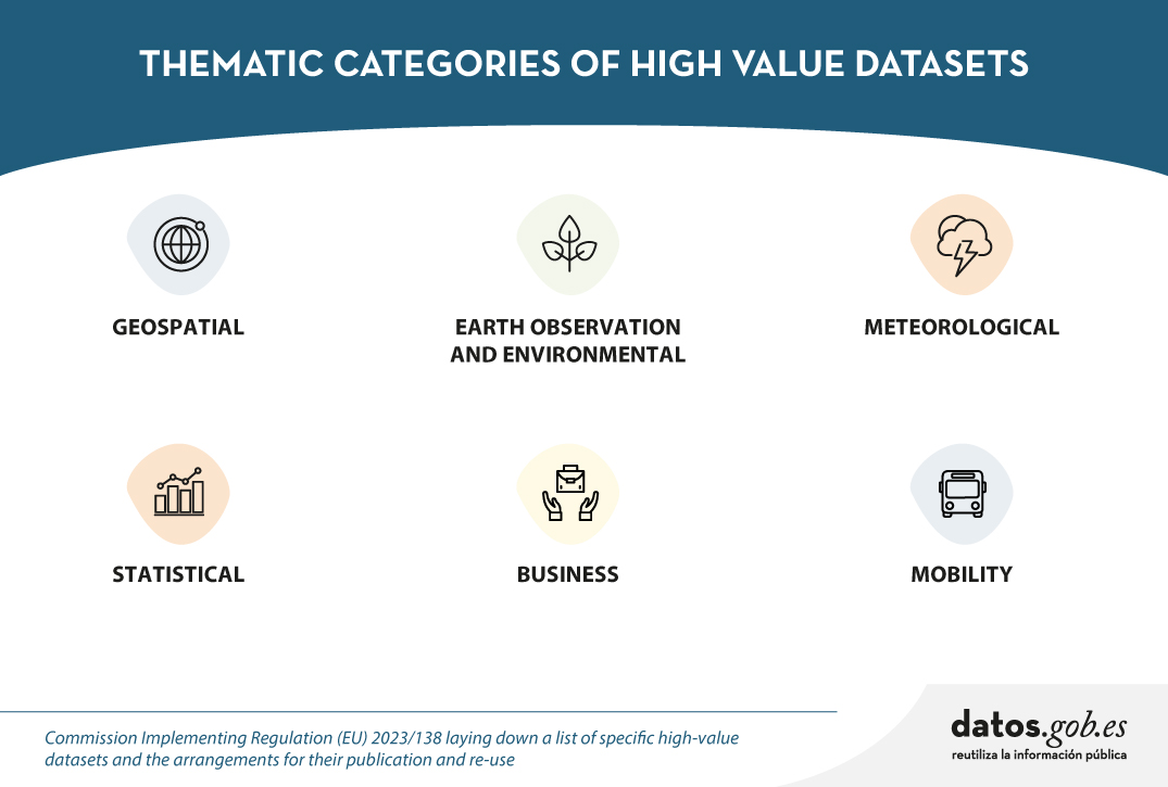
Spain, as part of the European Union, is committed to the implementation of the European directives on open data and re-use of public sector information. This includes the adoption of initiatives such as the Implementing Regulation (EU) 2023/138 issued by the European Commission, which defines specific guidelines for government entities with regard to the availability of High value datasets (HVD). These data are categorised into themes previously detailed in earlier discussions: Geospatial, Earth Observation and Environment, Meteorology, Statistics, Societies and Societal Properties, and Mobility. In this article we will focus on the last group mentioned.
The Mobility category encompasses data collections falling under the domain of "Transport Networks", as demarcated in Annex I of the Directive 2007/2/EC of the European Parliament and of the Council of 14 March 2007 establishing an Infrastructure for Spatial Information in the European Community (INSPIRE). In particular, this Directive refers to the requirement to make available to users datasets relating to road, rail, air and inland waterway networks, with their associated infrastructure, connections between different networks and the trans-European transport network, as defined by Decision No 1692/96/EC of the European Parliament and of the Council of 23 July 1996 on Community guidelines for the development of the trans-European transport network.
In addition, it includes the datasets as described in the Directive 2005/44/EC of the European Parliament and of the Council of 7 September 2005 on harmonised River Information Services (RIS) on inland waterways in the Community. The main objective of the Directive is to improve inland waterway traffic and transport, and it applies to canals, rivers, lakes and ports capable of accommodating vessels of between 1,000 and 1,500 tonnes. These datasets include:
| Data type | Inland waterways datasets |
|---|---|
| Static data |
|
| Dynamic data |
|
| Inland electronic and navigational charts (Inland ENC according to the Inland ECDIS Standard) |
|
Figure 1: Table with the high value datasets related to Directive 2005/44/EC for the creation of a trans-European river information network.
In order for all of us to make the most of the information available, the Regulation defines some basic rules on how this data is shared:
- Free and easy to use. The data must be ready to be used and shared with everyone for any purpose by acknowledging and citing the source of the data, as prescribed by the Creative Commons BY 4.0 licence.
- Easy to read and use. Data will be presented in a way that both people and computers can easily understand them and everything will be explained in public.
- Direct and easy access. There will be special ways (called APIs) that allow programs to access data automatically. In addition, the user can alternatively download a lot of information at once.
- Always up to date. It is important that data is up to date, so there will be access to the most recent version. But if the user needs to access previous data, it will also be possible to view previous versions.
- Detailed and precise. Data will be shared in as much detail as possible, to a very fine level of accuracy, so that the whole territory is covered when combined.
- Information on information. There will be "information about the information" (metadata) that will tell everything about the data. The metadata shall contain at least the elements listed in the Annex to Commission Regulation (EC) No 1205/2008 of 3 December 2008.
- Understandable and orderly: It will explain well how the data are organised and what all means, in a way that is easy for everyone to understand (structure and semantics).
- Common language. Data shall use vocabularies, code lists and categories that are recognised and accepted at European or global level.
in Spain, who is responsible for the creation and maintenance of mobility data?
In Spain, the responsibility for the creation and maintenance of mobility data generally lies with different governmental entities, depending on the type of mobility and the territorial scope:
- Level national level. The Ministry of Transport and Sustainable Mobility is the main body in charge of mobility in terms of infrastructure and transport at national level. This would include data on roads, railways, air and maritime transport.
- Regional and local level. Autonomous communities and municipalities also play an important role in urban and regional mobility. They are responsible for urban mobility, public transport and public roads, within their respective jurisdictions.
- Public business entities. There are entities such as ADIF (acronym for Administrador de Infraestructuras Ferroviarias, that is Railway Infrastructure Administrator), AENA (acronym for Aeropuertos Españoles y Navegación Aérea, that is Spanish Airports and Air Navigation), Puertos del Estado (State Ports) and others tentities hat manage specific data related to their field of action in rail, air and maritime transport, respectively.
In Spain, the Ministry of Transport and Sustainable Mobility, in collaboration with the autonomous communities, plays a key role in providing access to a wide range of mobility data. In compliance with INSPIRE and LISIGE (Law 14/2010 of 5 July 2010 on geographic information infrastructures and services in Spain, which transposes the INSPIRE Directive), it offers resources such as the Geoportal of the Spatial Data Infrastructure of Spain (IDEE in Spanish acronyms) where citizens and professionals can access geographic data and services, especially with regard to mobility.
Does Spain comply with the HVD Mobility Regulation?
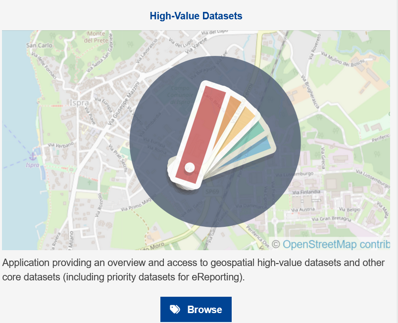
To solve this question we have to go to the INSPIRE Geoportal where official information classified as high value datasets in Europe is available. Specifically in the mobility category.

Figure 2: Screenshot of the Inspire Geoportal.
As of April 2024 Spain has published the following information in the INSPIRE Geoportal:
- Port service areas in Spain. The port service areas include the cartographic and alphanumeric information of the land service area and water areas I and II. The Spanish State-owned Port System is made up of 46 ports of general interest, managed by 28 Port Authorities.
- Spanish Transport Networks. The Transport Network of the Geographic Reference Information of the National Cartographic System of Spain is a three-dimensional network of national coverage, defined and published in accordance with the INSPIRE Directive, which contemplates five modes of transport: road, rail, inland waterways, air and cable, together with their respective intermodal connections and the infrastructures associated with each mode. This information has the linear geometry of the roads and the punctual geometry of the portals and kilometre points.
- ADIF''s Spanish Rail Transport Network. Public geographic dataset on the adaptation of the Spanish ADIF Common Traamification to the INSPIRE regulations (Transport Networks Annex I).
The publication of these high-value datasets responds positively to the question of Spain''s compliance with the HVD regulation, and is an achievement that reflects Spain''s continued commitment to transparency and access to mobility data.
The joint effort between the Ministry of Transport, Mobility and Urban Agenda, the National Cartographic System and the Autonomous Communities and Public Business Entities underlines the importance of a collaborative approach to mobility information management.
The availability of this data highlights Spain''s commitment to publishing high-value datasets and underlines the importance of continuously improving access to information to optimise inland navigation and mobility data.
Content prepared by Mayte Toscano, Senior Consultant in Data Economy Technologies. The contents and points of view reflected in this publication are the sole responsibility of its author.
Blog
The European Commission Implementing Regulation (EU) 2023/138 sets clear guidelines for public bodies on the availability of high-value datasets within 16 months from 20 January 2023. These high-value high value datasets (High value datasets or HVD) are grouped into the following themes, which were already described in this post: geospatial Earth observation and environment, Meteorology, Statistics, Societies and corporate ownership, and Mobility.
This article focuses on the category of Earth observation and environment, referred to as High Value Datasets for Earth Observation and Environment (HVDOM ).
Earth observation and environmental data in the regulation of high-value arrays
The HVDOM include data obtained in the following areas:
- Spatial or remotely sensed data.
- Ground or in situ data.
In particular, public bodies are faced with the obligation to make available to citizens high-value datasets that appear in various pieces of legislation:
- The environmental and climate datasets listed in the annexes of the Directive 2007/2/EC of the European Parliament and of the Council of 14 March 2007 establishing an Infrastructure for Spatial Information in Europe ( INSPIRE) indicated in the following visual:
| Inspire theme | Appendix |
|---|---|
| Hydrography | I |
| Protected sites | I |
| Elevations | II |
| Geology | II |
| Land cover | II |
| Orthoimaging | II |
| Areas to management, restrictions or regulations and reporting units | III |
| Biogeographical regions | III |
| Energy resources | III |
| Environmental observation facilities | III |
| Habitats and biotopes | III |
| Land use | III |
| Mineral resources | III |
| Natural hazard zones | III |
| Oceanographic geographical features | III |
| Production and industrial facilities | III |
| Marine regions | III |
| Soils | III |
| Species distribution | III |
2. Data sets produced in the context of legal acts and known as priority data, defined in the table below:
| Ámbito Medioambiental | Actos jurídicos que establecen las principales variables | |
|---|---|---|
| Air | Directive 2008/50/CE | Air Quality Directive |
| Directive 2004/107/CE | It adresses arsenic, cadmium, mercury, nickel and polycyclic aromatic hydrocarbons in ambient air. | |
| Climate | Regulation (UE) 2018/1999 | Governance of the Energy Union and Climate Action. |
| Regulation (CE) 1005/2009 | Substances that deplete the ozone layer. | |
| Emissions | Directive 2010/75/UE | Industrial Emissions Directive. |
| Directive 2012/18/UE | SEVESO III Directive. | |
| Directive 91/676/CEE | Nitrates Directive. | |
| Regulation (CE) 166/2006 | European Pollutant Release and Transfer Register. | |
| Regulation (UE) 2017/852 | Mercury Regulation. | |
| Directive (EU) 2016/2284 | Reduction of national emissions of certain atmospheric pollutants. | |
| Nature protection and biodiversity | Directive 2009/147/CE | Birds directive |
| Directive 92/43/CEE | Habitats Directive | |
| Regulation (UE) 1143/2014 | Invasive Alien Species Directive | |
| Data for the inventory of nationally designated protected areas (NDAAs), national biogeographic regions | EEA Annual Work Programme - Nationally Designated Areas - CDDA National legislation - National biogeographic regions | |
| Noise | Directive 2002/49/CE | Noise Directive |
| Waste | Directive 1999/31/CE | Landfill Directive |
| Directive 2006/21/CE | Directive on extractive waste | |
| Directive 86/278/CEE | Sewage Sludge Directive | |
| Directive 91/271/CEE | Urban Waste Water Treatment Directive | |
| Regulation (UE) 2019/1021 | Persistent Organic Pollutants (POPs) Regulation | |
| Recommendation 2014/70/UE | Recommendation on hydraulic fracturing | |
| Water | Directive 91/271/CEE | Urban Waste Water Treatment Directive |
| Directive 98/83/CE | Drinking Water Directive | |
| Directive 2006/7/CE | Bathing Water Directive | |
| Directive 2000/60/CE | Water Framework Directive | |
| Directive 2006/118/CE | Groundwater Directive | |
| Directive 2008/105/CE | Environmental Quality Standards Directive | |
| Directive 2020/2184/UE | Drinking Water Directive | |
| Directive 2007/60/CE | Floods Directive | |
| Directive 2008/56/CE | Marine Strategy Framework Directive | |
| Horizontal legislation | Directive 2004/35/CE | Prevention and remediation of environmental damage |
| Regulation (UE) 2020/852 | EU Taxonomy | |
At this URL of the INSPIRE register, the list of datasets related to environmental reporting, to be made available by Member States in a step-by-step manner, is published.
To ensure the accessibility and re-use of all these valuable datasets, it is imperative to follow certain provisions to facilitate their publication. Here are the key requirements, which are common to all categories:
- Open licence: All datasets must be made available for reuse under a licence Creative Commons BY 4.0 or any equivalent less restrictive open licence. This encourages the freedom to share and adapt information.
- Open and machine-readable format: Data should be presented in an open, machine-readable format and be publicly documented. This ensures that the information is easily understandable and accessible to any person or automated system.
- Application Programming Interfaces (APIs) and bulk downloading: Application programming interfaces (APIs) should be provided to facilitate programmatic access to data such as direct access download services like Web Feature Services, WFS. In addition, direct bulk downloading of datasets should be possible, allowing flexible options for users according to their needs
- Updated version: The availability of datasets in their most up-to-date version is essential. This ensures that users have access to the latest information, promoting the relevance and accuracy of data. Therefore, it will be necessary to have the most up-to-date datasets as well as historical versions of the available datasets.
- Scale and granularity: Data will need to be published at the available levels of generalisation up to the scale of 1:5000, and covering the whole Member State when combined. If datasets are not available at this scale, but are available at higher spatial resolutions, they shall be provided at the available spatial resolution.
- Metadata: The metadata describing the data concerning the set of themes within the scope of the INSPIRE infrastructure for spatial information shall contain at least the metadata elements set out in the Annex to the Commission Regulation (EC) No 1205/2008 of 3 December 2008of 3 December 2008.
- Semantics: The datasets shall be described in a comprehensive and publicly available online documentation describing at least the data structure and semantics.
- Vocabularies: The datasets shall use Union-controlled or internationally recognised and publicly documented vocabularies and taxonomies. Such as the checklists defined in the INSPIRE register.
In Spain, who is responsible for the creation and maintenance of the Earth Observation and Environment HVDs ?
There are several organisations responsible for these datasets, for example, at the national level, we highlight:
- The National Cartographic System (NCS), which publishes orthoimagery, hydrography, elevations, land use or land cover.
- The Geological and Mining Institute (IGME), responsible for geological data.
- The Spanish Institute of Oceanography (IEO) of the Spanish National Research Council (CSIC) is responsible for oceanographic features.
- The General Directorate of Cultural Heritage and Fine Arts of the Ministry of Culture publishes the protected sites of historical heritage and culture.
- The Ministry for Ecological Transition and Demographic Challenge (MITECO) and the Ministry of Agriculture, Fisheries and Food (MAPA) are responsible for the datasets subject to other environmental legislation, the priority data.
All these organisations play a crucial role in the implementation and enforcement of the INSPIRE Directives INSPIRE Directives y LISIGE (Law on Geographic Information Infrastructures and Services in Spain), both of which are fundamental in the management of geographic and environmental information.
- The INSPIRE Directive was developed in cooperation with the Member States and accession countries of the European Union. Its main objective is to make available the geographical information needed for the management of EU environmental policies.
- In Spain, it is transposed by Law 14/2010, known as LISIGE, which was subsequently amended by Law 2/2018 Law 2/2018. This law regulates geographic data and services, applying to those that refer to a geographic area of the national territory and that have been generated or are under the responsibility of public administrations. These data must be in electronic format and be the responsibility of a public sector administration or body.
Both the SCN an instrument regulated by the LISIGE that publishes geographic information through the coordination of national organisations and the Autonomous Communities, has been set up by the LISIGE. The Spanish and Spanish public administrations, such as MITECO and MAPA, in coordination with the autonomous communities, provide access to a wide range of data and information related to biodiversity, climate change, environmental quality and many other environmental issues. This includes the maintenance of the Spatial Data Infrastructure (SDI) of MITECO and MAPA, which is aligned with the INSPIRE, environmental and LISIGE Directives, publishing the datasets through interoperable services and locatable in the Official Catalogue of INSPIRE Data and Services (CODSI)where geographic data and services regulated by the LISIGE on environmental and Earth observation matters are available .
We highlight, for example, that MITECO is making efforts to ensure the adaptation of the main datasets of the Spanish Inventory of Natural Heritage and Biodiversity to the INSPIRE Directive, covering topics such as biogeographic regions, habitats, biotopes and species distribution.
MITECO plays an essential role in the implementation of the INSPIRE and LISIGE Directives in Spain, providing access to key geographic data and information for the management of environmental policies and the protection of natural heritage, as historical and cultural heritage falls under the Ministry of Culture.
Does Spain comply with the HVD Regulation on Earth observation and environment?
Thanks to the continued work of the Consejo Directivo de la Infraestructura de Información Geográfica de España (CODIIGE) since the implementation of LISIGE, Spain has reached an important achievement. Currently, in the INSPIRE Geoportal portal is currently available a wide variety of information, classified as high-value Earth observation and environmental datasets. This information comes from the resources stored in CODSI.

As of May 2024, Spain has published the following information on the CODSI Geoportal:
- INSPIRE Datasets: The number of datasets published by Spain in each of the mandatory INSPIRE themes is shown below.
| INSPIRE Themes | Number of published datasets |
|---|---|
| Hydrography | 33 |
| Protected sites | 27 |
| Elevations | 20 |
| Geology | 10 |
| Land cover | 60 |
| Orthoimaging | 16 |
| Areas to management, restrictions or regulations and reporting units | 147 |
| Biogeographical regions | 1 |
| Environmental observation facilities | 100 |
| Energy resources | 10 |
| Habitats and biotopes | 9 |
| Land use | 25 |
| Mineral resources | 0 |
| Natural risk areasl | 70 |
| Oceanographic geographical features | 2 |
| Facilities production and industrial | 27 |
| Species distributions | 10 |
| Soil | 17 |
| Marine regions | 9 |
| GENERAL TOTAL | 593 |
See here for the definition of each of the INSPIRE themes.
- Environmental legislation: refers to priority datasets grouped by relevant environmental reporting legislation. The commission called these datasets "Priority Data" to reinforce their importance once the baseline data were already published


https://inspire-geoportal.ec.europa.eu/srv/eng/catalog.search#/qsEnvDom…
All categories are listed below (also indicating those that do not apply to Spain with the acronym N/D):
| Environment | Legal acts establishing the main variables | ||
|---|---|---|---|
| Air | Directive 2008/50/CE | Air Quality Directive | 4 |
| Directive 2004/107/CE | It adresses arsenic, cadmium, mercury, nickel and polycyclic aromatic hydrocarbons in ambient air. | N/D* | |
| Climate | Regulation (UE) 2018/1999 | Governance of the Energy Union and Climate Action. | 0 |
| Regulation (CE) 1005/2009 | Substance that deplete the ozone layer | 0 | |
| Emissions | Directive 2010/75/UE | Industrial Emissions Directive | 1 |
| Directive 2012/18/UE | SEVESO III Directive | 0 | |
| Directive 91/676/CEE | Nitrates Directive | 5 | |
| Regulation (CE) 166/2006 | European Pollutant Release and Transfer Register | 2 | |
| Regulation (UE) 2017/852 | Mercury Regulation | 0 | |
| Directive (EU) 2016/2284 | Reduction of national emissions of certain atmospheric pollutants | 0 | |
| Nature protection and biodiversity | Directive 2009/147/CE | Birds Directive | 3 |
| Directive 92/43/CEE | Habitats Directive | 8 | |
| Regulation (UE) 1143/2014 | Invasive Alien Species Directive | 1 | |
| Data for the inventory of nationally designated protected areas (NDAAs), national biogeographic regions | EEA Annual Work Programme - Nationally Designated Areas - CDDA and National Legislation - National Biogeographic Regions | 0 | |
| Noise | Directive 2002/49/CE | Noise Directive | 0 |
| Waste | Directive 1999/31/CE | Landfill Directive | 2 |
| Directive 2006/21/CE | Directive on extractive waste | 1 | |
| Directive 86/278/CEE | Sewage Sludge Directive | 1 | |
| Directiva 91/271/CEE | Urban Waste Water Treatment Directive | 9 | |
| Regulation (UE) 2019/1021 | Persistent Organic Pollutants (POPs) Regulation | 0 | |
| Recommendation 2014/70/UE | Recomendation on hydraulic fracturing | 0 | |
| Water | Directive 91/271/CEE | Urban Waste Water Treatment Directive | 9 |
| Directive 98/83/CE | Drinking Water Directive | 0 | |
| Directive 2006/7/CE | Bathing Water Directive | 1 | |
| Directive 2000/60/CE | Water Framework Directive | 17 | |
| Directive 2006/118/CE | Groundwater Framework Directive | N/D* | |
| Directive 2008/105/CE | Environmental Quality Standards Directive | 0 | |
| Directive 2020/2184/UE | Drinking Water Directive | 0 | |
| Directive 2007/60/CE | Floods Directive | 31 | |
| Directive 2008/56/CE | Marine Strategy Framework Directive | 4 | |
| Horizontal legislation | Directive 2004/35/CE | Prevention and remediation of environmental damage | N/D* |
| Regulation (UE) 2020/852 | EU Taxonomy | N/D* | |
| Total | 99 | ||
*N/D= No data, these categories do not apply to Spain
The publication of all these high-value datasets is an achievement that reflects our country''s continued commitment to transparency and access to high-quality environmental and Earth observation data.
Spain has made significant progress in complying with the High Value Sets of Earth Observation and Environment Regulation, with a remarkable amount of datasets available through the INSPIRE Geoportal. This ranges from Directive 2008/50/EC on air quality to Directive 2008/56/EC on Marine Strategy, reflecting a holistic approach to environmental information management.
Compliance with European Directives and regulations demonstrates Spain''s commitment to transparency and access to high quality environmental information. In addition, efforts to ensure the updating and accessibility of data are highlighted, including the adaptation of the main datasets of the Spanish Inventory of Natural Heritage and Biodiversity to the INSPIRE Directive.
The joint effort between MITECO, MAPA and the National Cartographic System and the autonomous communities underlines the importance of a collaborative approach to the management of environmental information and Earth observation, fundamental in the protection and sustainable development of natural heritage.
In short, we can say that Spain currently complies with the HVD Regulation in almost all categories, but does not comply in the following categories:
No API or bulk download
- Orthoimaging
- Oceanographic geographical features
Lack of data related to the following environmental legislation:
- Directive 98/83/EC - Drinking Water Directive
- Directive 2002/49/EC - Noise Directive
- Directive 2012/18/EU - SEVESO III Directive
- National legislation - National bio-geographical regions
- Recommendation 2014/70/EU - Recommendation on hydraulic fracturing
- Regulation (EU) 2017/852 - Regulation of Mercury
In summary, Spain has demonstrated a strong commitment to transparency and accessibility to high quality environmental information, complying with most European directives, although it still needs to improve in specific areas such as the provision of APIs and the updating of certain environmental datasets.
Content prepared by Mayte Toscano, Senior Consultant in Data Economy Technologies. The contents and points of view reflected in this publication are the sole responsibility of the author.
Blog
Geographic data allow us to learn about the world around us. From locating optimal travel routes to monitoring natural ecosystems, from urban planning and development to emergency management, geographic data has great potential to drive development and efficiency in multiple economic and social areas. They are therefore considered high-value datasets by the European Commission, and have a specific obligations to make their publication accessible and interoperable.
In order to understand the real impact of this type of data, several reports and studies have been carried out. The following are several of them, which address the challenge of measuring the impact of geographic information.
Geospatial data in the Ministry of Transport and Sustainable Mobility. Impact of information co-produced by IGN and CNIG (2024)
- You can read the full report here.
This report, produced by ASEDIE and CNIG, aims to draw conclusions about the use and perception of the services co-produced by National Geographic Institute (IGN) and National Centre for Geographic Information (CNIG) in order to understand the benefit they bring to the daily activity of the companies that use them and to society. For this purpose, a survey was carried out among companies using geospatial data, thanks to which a classification of companies reusing geographic data could be drawn up.
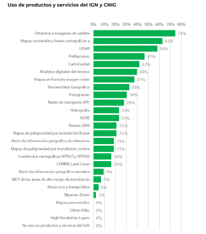
Of the 170 companies considered, 70.0% are self-employed and micro-enterprises (less than 10 employees). These companies are mainly located in the Community of Madrid (25.6%), Catalonia (16.3%), Andalusia (14%), Valencia (11.6%) and Castilla y León (11.6%). 53.3% claim to reuse data from Spatial Data Infrastructures (SDI) and 51% open data from INE, among others. The most used products are orthophotos and satellite images (74%), followed by vector maps and cartographic and topographic databases (63%), and LiDAR (58%).
In terms of economic impact, the report estimates an average impact of 35.7% on the sales of the companies surveyed. Specifically, open geographic information from the IGN and CNIG account for an impact of 12.4% of sales.
The report also includes the analysis of collected use cases, as well as in-depth interviews with companies in the sector as examples of best practices and, on the other hand, updates the information from Asedie's annual report on the Data Economy in its 2023 infomediary scope with respect to the economic data of the geographic subsector.
Economic benefits of the SDI central node by CNIG and University of Leuven (2021)
- You can read the full report here.
This document develops and tests a methodology for estimating the economic benefits generated by the Spanish Spatial Data Infrastructure (IDEE), which establishes the publication and accessibility of spatial data through free geographic web services for viewing and downloading produced by cartographic, environmental, cadastral and land observation organisations at national, regional and local level since 2004, in accordance with norms, standards and recommendations that guarantee their interoperability.
The study was to answer the question of what would happen if the NSDI were to disappear. For the study, only the central node of the NSDIE was considered, understanding as such the geographic services and data co-produced among the partners of the National Cartographic System, and focusing on web map services (WMS) and map tiles (WMTS). The nodes of ministries, autonomous communities and local entities were not part of its scope.
Two investigation paths were used to carry out the calculation:
- Comparison with the costs of using Google Maps. The application of the different scenarios led to a profit/value of the 6 WMTS and 13 WMS of minimum 355,646 and maximum 891,144 euros.
- Comparison with other countries' charges for the use of their data and services. Despite the difficulties in calculating the rate per application, due to the existence of different approaches in each country, the total value of the FDIE was estimated at between 34,000 and 14 million euros.
This report joins others produced by the NSDI, such as these documents to estimate the average cost of metadata generation or the implementation of visualisation and download services for Inspire-compliant datasets, both carried out in 2019.
In order to allow other organisations to adapt the study to their particularities, an Excel file has been created, as a calculator, with the following calculation template.
ICEARAGON and ARAGEA Performance Report by the Government of Aragon (2024)
- You can read the full report here.
Regional governments are also interested in knowing the impact of their geographic information services. This is the case of the Government of Aragon, which recently presented a report on the performance of the Spatial Knowledge Infrastructure of Aragon (ICEARAGON) and the Active Geodesy Network of Aragon (AREAGA).
In total, these services are estimated to have saved almost two million euros for all Aragonese citizens by 2023. According to the report, ICEARAGÓN received almost 5 million visits in 2023, an increase of 58.6% over 2022. These users made 1.7 million downloads. Most of the information downloaded (47.8%) refers to environmental layers. Information on administrative boundaries (13.8%) and maps of Aragon (13.4%) were also very successful. Regarding the user profile, 71% are from the surveying field and 27% belong to the agricultural sector.
These reports serve as a basis for the work of the European Commission on a regular basis, compiling progress in the different areas of INSPIRE implementation. As a result of this work, annual reports are generated for each country, including a section on costs and benefits.
All this work on measuring and estimating benefits highlights the economic value of providing geographic data and services to society. As a result, new products and services can be created that boost the economy of the whole country and provide benefits to all its citizens.
Blog
The Implementing Regulation (EU) 2023/138 of the European Commission sets clear guidelines for public bodies on the availability of high-value datasets within 16 months. These high-value datasets are grouped into the following themes, which were already described in this post post:
This article focuses on the geospatial category, called High-Value Geospatial Datasets (HVDG).
For all HVDGs, the following shall apply Directive 2007/2/EC of the European Parliament and of the Council of 14 March 2007 establishing an infrastructure for spatial information in the European Community (INSPIRE) with the exception of agricultural and reference parcels, for which Regulation (EU) 2021/211/EEC applies Regulation (EU) No 2021/2116 of the European Parliament and of the Council of 2 December 2021.
As reflected in the table below, the regulation provides detailed information on the requirements to be considered for these HVDGs, such as scales or granularity and attributes of each dataset. These are complementary to the attributes defined in the European Regulation (No 1089/2010), which establishes the interoperability of spatial data sets and services.
| Datasets | Scales | Attributes |
|---|---|---|
| Administrative units |
Levels of generalisation available with a granularity down to the scale of 1:5 000. From municipalities to countries; maritime units. |
|
| Geographical names |
Not applicable. |
|
| Directorates | Not applicable. |
|
| Buildings | Levels of generalisation available with a granularity up to the scale of 1:5 000 |
|
| Cadastral parcels | Levels of generalisation available with a granularity up to the scale of 1:5 000 |
|
| Reference areas | Levels of generalisation available with a granularity up to the scale of 1:5 000 |
|
| Agricultural areas | Level of accuracy equivalent to 1:10 000 scale and from 2016, 1:5 000 scale |
|
To ensure the accessibility and re-use of all these valuable datasets, it is imperative to follow certain provisions to facilitate their publication. Here are the key requirements:
- Open Licence: All datasets must be made available for re-use under a licence Creative Commons BY 4.0 or any equivalent less restrictive open licence. This encourages the freedom to share and adapt information.
- Open and Machine Readable Format: Data should be presented in an open, machine-readable format and be publicly documented. This ensures that the information is easily understandable and accessible to any person or automated system.
- Application Programming Interfaces (APIs) and Mass Download: Application programming interfaces (APIs) should be provided to facilitate programmatic access to data. In addition, direct bulk downloading of datasets should be possible, allowing flexible options for users according to their needs.
- Updated version: The availability of datasets in their most up-to-date version is essential. This ensures that users have access to the latest information, promoting the relevance and accuracy of data.
- Metadata: The description of the data will also be carefully taken care of through the use of metadata. This metadata shall, as a minimum, include the elements as defined in Commission Regulation (EC) No 1205/2008 of 3 December 2008. This regulation implements Directive 2007/2/EC of the European Parliament and of the Council and sets standards for metadata associated with datasets. The use of standardised metadata provides additional information essential for understanding, interpreting and using datasets effectively. By following these standards, interoperability and consistency in reporting is facilitated, thus promoting a more complete and accurate understanding of the available data.
These provisions not only promote transparency and openness, but also facilitate collaboration and the effective use of information in a variety of contexts.
Does Spain comply with the Geospatial HVD Regulation?
The INSPIRE (Infrastructure for Spatial Information in Europe) Directive determines the general rules for the establishment of an Infrastructure for Spatial Information in the European Community based on the Infrastructures of the Member States. Adopted by the European Parliament and Council on 14 March 2007 (Directive 2007/2/EC), entered into force on 25 April 2007.
INSPIRE makes it easier to find, share and use spatial data from different countries and in each of the regions, with HVDs available in the the Commission's new catalogue of HVDs and in each of the catalogues of the Spatial Data Infrastructures of the Autonomous Communities, as well as in the Official INSPIRE Data and Services Catalogue of Spain. The information is available through an online platform whit data from different countries.
WARNING!: They are currently working on this Geoportal carrying out the tasks of data dump, therefore, there may be some temporal inconsistency with the data provided, which correspond to the Official Catalogue of INSPIRE Data and Services (CODSI).
In Spain, we can find the Law 14/2010 of 5 July 2010 on geographic information infrastructures and services in Spain (LISIGE), which transposes Directive 2007/2/EC INSPIRE. This law frames the work to make all national spatial data available and obliges the adaptation of national spatial data to the Technical Guides or Guidelines collected by the INSPIRE Directive, thus ensuring that these data are compatible and interoperable in a Community and cross-border context.
LISIGE applies to geographic data that meet these conditions:
- Refering to a geographical area of the national territory, the territorial sea, the contiguous zone, the continental shelf and the exclusive economic zone.
- Having been generated by or under the responsibility of public administrations.
- Being in electronic format.
- Their production and maintenance is the responsibility of a public sector administration or body.
- Being within the themes of Annexes I (Geographic Reference Information), II (Fundamental Thematic Data) or III (General Thematic Data) referred to in the aforementioned law
Furthermore, it is clarified that the geographic data and services regulated by the LISIGE will be available on the NSDI Geoportal and on the CODSI as well as in the rest of the catalogues of the Autonomous Communities. The National Geographic Institute (IGN) is responsible for its maintenance.
Thanks to the tireless efforts of the entire Spanish administration since the publication of LISIGE, Spain has achieved a remarkable milestone. It is currently available on the INSPIRE Geoportal a wide range of information classified as High Value Geospatial Data Set (HVDG) is now available on the INSPIRE Geoportal. This achievement reflects our country's continued commitment to transparency and access to high quality geospatial data.
As of January 2024 Spain has published in the INSPIRE Geoportal and in CODSI the following information related to the High Geospatial Value Datasets (HVD)
- 31 datasets associated with their metadata
- 34 download services (WFS, ATOM Feed, OGC Api Feature)
- 28 visualisation services (WMS, WMTS)
Analysing the sets of high geospatial value we see that, according to the thematics, they have already been published:
| HVDG Spain | Datasets | Download services | Visualisation services | Covers Spanish territory |
|---|---|---|---|---|
| Administrative units |
5 | 7 | 7 | Sí |
| Geographical names |
7 | 8 | 8 | Sí |
| Directorates | 6 | 5 | 7 | Sí |
| Buildings | 5 | 3 | 4 | Sí |
| Cadastral parcels | 3 | 3 | 3 | Sí |
| Reference areas | 3 | 0 | 3 | Sí |
| Agricultural areas | 2 | 2 | 2 | Sí |
Spain currently complies with the HVDG Regulation in all categories. Specifically, it complies with the established legislation at the level of scale or granularity, attributes, license, format, availability of the data in API or maximum download, with being the most updated version and with the metadata.
A detailed analysis of the datasets published under the HVD framework highlights several key issues:
- Comprehensive Geographic Coverage: At least one dataset covering the whole of Spain has been made available.
- Comprehensive Metadata: Metadata has been generated for all High Geospatial Value Datasets (HVDGs). These metadata are published in the Official INSPIRE Catalogue of INSPIRE Data and Services (CODSI), validated to comply with the standards of the Commission Regulation (EC) No 1205/2008.
- Viewing and Downloading Services: All HVDGs have viewing and download services. Download services can be bulk download or download APIs. Currently, they are WFS and ATOM. In the future may be OGC API Feature or API Coverage.
- Open Licences and Open Formats: All published services are licensed under Creative Commons BY 4.0, and download services use standard and open formats such as the GML format documented by the international standard ISO 19136.
- Compliance with INSPIRE Data Models: Almost all datasets comply with the INSPIRE data models, thus ensuring the consistency and quality of the attributes set out in the HVDG regulation.
- Data Updated and Maintained: Download services guarantee the availability of data in the most up-to-date version. Each public administration responsible for the data is responsible for maintaining and updating the information.
This analysis highlights the commitment and efficiency in the management of geospatial data in Spain, contributing to the transparency, accessibility and quality of the information provided to the community.
It should be noted that, in Spain, all HVDG requirements are met. Organisations such as the CNIG and the ICGC or the Government of Navarre, in addition to publishing through WFS or ATOM services, are already working on publishing these datasets with the APIs of OGC.
The INSPIRE Geoportal has become a valuable source of information, thanks to the dedication and collaboration of various governmental entities, including Spanish ones. This breakthrough not only highlights progress in the implementation of geospatial standards, but also strengthens the basis for sustainable development and informed decision-making in Spain. A significant achievement for the country in the geospatial field!
Content prepared by Mayte Toscano, Senior Consultant in Data Economy Technologies. The contents and points of view reflected in this publication are the sole responsibility of its author.
Evento
The INSPIRE 2020 conference was to have been held between 11-14 May in Dubrovnik. However, the global pandemic in which we are immersed forced its postponement, as happened with a large number of informative, cultural or sports events.
In this situation, the organising committee has not given up, and has launched a virtual edition that will take place from June 3 to 12.
What is the event about?
The event will take place under the motto: “Bringing sustainability and digitalization together”. The idea is to debate how the transition to the digital world could help build a more sustainable Europe, but without forgetting what are the environmental, economic and social problems and risks that digitization entails.
In this process of finding a balance between sustainability and digitization, data and artificial intelligence are essential, as evidenced in the European Green Deal. More and more voices are raised in favour of the development of a specific digital ecosystem for this area, focused not only on data, infrastructure and algorithms, but also on their analysis and the implementation of ideas and applications. Specifically, the Green Deal refers to accessible and interoperable data, and its combination with digital infrastructure (supercomputers, clouds, ultrafast networks) and artificial intelligence solutions, as keys to the EU's economic strategy to emerge from the crisis linked to the Covid-19 pandemic.
During the event, innovative ways to use data and digital solutions for the implementation of policies that seek to achieve sustainable development goals will be shown, with the focus on the circular economy and the reduction of carbon levels. All this will guide future work on existing data legislation, in particular the INSPIRE Directive.
What is the INSPIRE Directive?
The INSPIRE Directive establishes a series of general rules for the creation of a Spatial Information Infrastructure in the European Union, based on the Infrastructures of the member states. Its objective is to promote the availability of quality geographic information, which serves to formulate, implement, monitor and evaluate policies in the EU. Its transposition into the Spanish legal system is developed through the so-called LISIGE law.
INSPIRE's legal roadmap is coming to an end, however the evolution of infrastructure will continue. For this process to be successful, we must ensure its sustainability in collaboration and partnership with other actors beyond the initial scope of the Directive, a process that can be driven by events such as the INSPIRE 2020 conference.
What is the Conference program?
The program scheduled for the May event had to be adapted. Organizers of special sessions and workshops have been invited to adapt their participation in the form of webinars. Although in some cases it was not possible, a large number of participants accepted the invitation. Thanks to this, an interesting program has been created, which you can see at this link. By clicking on each presentation, you can see a summary of the specific contents that will be discussed in the slot.
There will be sessions focused on statistical and geospatial data, public-private partnerships, or democratizing the use of data. The Green Deal will also be discussed, for example, the role of Smart cities in achieving sustainability objectives or the importance of building a common data space, and specific examples of work in this direction will be shown, such as the ICT4Water cluster.
How to attend the seminars?
All seminars are free. To attend you have to register individually in each of them. It is a unique opportunity to catch up on what is happening in Europe related to the Inspire directive, and the role of open data in achieving a sustainable and digital Europe.
Noticia
The Spatial Data Infrastructure of Spain (in Spanish ‘IDEE’) is an ambitious project to harmonize and merge the geographical data handled by all Spanish public administrations, as well as the current geographic information services. The final goal of the project is to make all these valuable data accessible through the Internet and with an integrated format that increases its usefulness.
Like any effort to integrate data, metadata or information services, the IDEE implicitly entails an important effort to complete and standardize data, and to make it accessible by complying not only with interoperability standards and technical protocols, but also with the corresponding legal frameworks. But, as often happens in this kind of situations, other initiatives can subsequently benefit from a series of positive externalities in the form of technological advances for the participants or improvements of the coordination processes.
The body in charge of coordinating the IDEE is the Ministry of Infrastructure through the High Geographic Council, which is a collegiate body in which all the producers of digital geographic data are represented. It is intended to be integrated in the three levels of government existing in Spain. The IDEE also collaborates with research teams from universities and public and private companies that work with geographic information technologies.
The Geographical High Council also acts as a point of contact with the European Commission for the implementation of the Inspire Directive (Infrastructure for Spatial Information in Europe) in Spain, which provides legal framework at European level. Inspire establishes the general rules for the establishment of a Spatial Information Infrastructure in the EU, with a clear environmental vocation and based on the compatible and interoperable infrastructures of the Member States. It also propose, since 2007, a model to encourage the opening and reuse of geographic data that has been used as an example for the promotion of open data policies in the public sector at European level, including the Directive on the reuse of information in the public sector.
Some of the benefits that have already been materialized as a result of the IDEE are the large geographic information production projects that we have described among the digital treasures of the National Geographic Institute, such as the National Aerial Orthophoto Plan (PNOA) or the Information System on Land Use of Spain (SIOSE).
In the IDEE geoportal, all data sets, metadata and geographic information services that are integrated into the project are published. The geoportal includes services such as a data catalog that allows locating and accessing different sets of data and metadata or a map viewer that allows even panoramic flights. Of course, the data sets are available not only for making an inquiry, but it is also possible, in most cases, to download them as open data for later reuse by interested users.
In the geoportal resources section of the IDEE there are also two sections that provide special added value beyond the datasets themselves:
- A collection of free tools of different nature useful for working with geographic data. Among the free tools we can find, for example, different map viewers that can be integrated into third-party web applications. These are data visualization apps based on maps that have been developed by different regional governments and have been made available to the public through an application programming interface (API) as part of their spatial data infrastructures (IDE). The section also highlights services such as the download of geographic objects asynchronously based on the Web Processing Service (WPS) standard, services for the transformation of coordinates or 3D viewers.
- The developer's corner, where we can find a set of reference documents for application developers that use geographic data sets. These documents have been created based on the Technical Guidelines for Network Services of the Inspire Directive and the specifications of the Open Geospatial Consortium (OGC). We can find for example a Guide to integrate WMS and WFS services in various applications or a technical guide related to the Visualization Service (WMS) or the Download Service (WFS 2.0.0). These documents are very useful for the development of visualization, download and localization services with different tools.
According to the Reusing Open Data report, elaborated by the European Data Portal, geographic data is the second data category most reused and consulted by companies in the member states of the European Union. Both in terms of data sets availability and harmonization, geographic data have a maturity degree that we still do not find in other sectors. In addition, we can say that, in terms of geographic information, Spain has not been limited to follow the trail of European legislation, whose deployment will not be completed until 2021, but has represented an example in its commitment and has gone beyond the minimum obligations imposed by Inspire.
Content prepared by Jose Luis Marín, Head of Corporate Technology Startegy en MADISON MK and Euroalert CEO.
Contents and points of view expressed in this publication are the exclusive responsibility of its author.
Noticia
The geographical information generated in any field, and in particular in the public field, has a great interest both for the specific tasks for which it is generated and maintained and for other applications, in many cases not initially planned, and it has a great potential for the development of the knowledge society. With these words begins the Statement of Motives of Law 14/2010, of July 5, on infrastructures and geographic information services in Spain (LISIGE), through which INSPIRE is incorporated into Spanish legislation.
It is unquestionable that the development of information and communication technologies has allowed the integration of data obtained from different sources. From these data can be articulated value-added services based on interoperability. However, beyond these technological premises and, undoubtedly, the obvious economic interest linked to such services, the fact is that the popularization of geographic information services with an indisputable added value can only be explained in the last instance, at least since the legal point of view, in the adequate configuration of the normative framework they are based on. Therefore, it is interesting to identify the keys to the regulatory model that, in short, could serve as a teaching tool for other sectors of public activity in which an effective open data policy could encourage their reuse.
What are those characteristic features of the regulation related to infrastructures and geographic information services access?
- In the first place, an unquestionable advantage is the specific European regulation, the INSPIRE Directive approved in 2007, which makes possible to ensure that the spatial data infrastructures of the Member States are compatible and interoperable in a community and cross-border context. Apart from the general provisions on access and reuse, its purpose is to facilitate the application of public policies based on geographic information; in addition, it is not coincidental that said information is intimately linked to a field such as the environment, where there is a specially rigth-based legal regime when it comes to facilitating access to information
- On the other hand, some fact should be emphasized: data must be in electronic format and the use of metadata, whose scope and content are even legally established as regards their main requirements, is inexcusable.
- The establishment of a clear and unambiguous legal obligation to respect the requirements of standardization and interoperability. It is important to keep in mind that, on the one hand, the general rules of the National Interoperability Scheme, required for any public activity that uses electronic means, must be respected; and, on the other hand, the uniqueness of geographic information systems requires that they be completed with specific rules that are established by a single body - the Geographic High Council - taking into account international standards.
- The articulation of the system based not only on the principle of coordination but, above all, on the cooperation of various public entities; a premise of singular relevance in a decentralized organizational context such as the Spanish one, where various administrative levels have their own autonomy recognized. In this regard, beyond generic and inaccurate legal declarations, mutual access to data and services is legally established, except in the case of a judicial decision or, as the case may be, the concurrence of any of the justified causes provided by law, that is, public security, national defence, the existence of emergencies or international relations. Moreover, the legislator's commitment is unequivocal in establishing an express prohibition of restrictions that prevent the sharing of data, unless there is a specific legal provision.
- Regarding the restrictions on data access, the regulation starts from the establishment of assessed assumptions that, likewise, are the object of a precise wording that leaves little room for interpretation.
- Even when the possibility of demanding the collection of fees or public prices is contemplated, however, its amount is limited to the minimum required to guarantee data and services quality. Likewise, certain cases of gratuity are contemplated, as happens with the information linked to European regulatory obligations related to environment protection. Similarly, it also declares the general nature of certain localization and visualization services, unless there are objective circumstances that justify the collection of the public rate or price, as happens singularly with the large amounts of data that require continuous updating. From these perspective, the conditions of use of the Download Center of the National Geographic Information Center are established based on a license for use compatible with CC-BY 4.0, which covers free use for any legitimate purpose.
- Finally, without any exhaustive spirit, it seems relevant the support of a reference administrative instrument such as the cadastre, which must necessarily include real estate. Therefore, it becomes one of the axes of geographic information with minimum guarantees of precision and accuracy.
In short, the fact that the applicable legal regime facilitates the integration of any source throughout Spain and the European Union, sources that can be shared between different users and applications; that it is possible to share geographical data collected at a certain level of the Administrations and public sector bodies with other public organisations; that geographical data may be disseminated under conditions that do not unduly restrict its widespread use; and that it is possible to locate the available geographic data, evaluate its suitability for a specific purpose and know its conditions of use, as well as its legal and technical effects, are inexcusable premises to understand the promotion of services in this sector.
Once again, the legislator's own words in explaining the scope of the established measures, in short, enumerate the undeniable conditions that have contributed to facilitating the reuse of geographic information. Could we replicate this regulatory model in other areas?
Content prepared by Julián Valero, professor at the University of Murcia and Coordinator of the Research Group "Innovation, Law and Technology" (iDerTec).
Contents and points of view expressed in this publication are the exclusive responsibility of its author.