Blog
More than 2.5 billion tonnes. That is the amount of waste that, according to the European Union, is produced every year in the EU - although the specific figure is from 2016 -, with the consequent danger to the environment and our own future. This worrying situation is leading the European institutions to promote a change of model in waste management.
For years, waste management has been linear, i.e. natural resources are extracted, used to produce a certain good, consumed and then discarded. This system requires large amounts of energy and cheap, easily accessible materials. Part of this model are also practices such as programmed obsolescence, very common in the technological field, where the company "programs" the end of the useful life of the product, in such a way that after a certain period of time it stops working.
This linear model is not viable in the long term, which is why more and more people are calling for a change to a management based on the circular economy.
What is the circular economy?
Circular economy refers to an economic system that replaces the concept of 'end-of-life' with 'reduce, reuse, recycle and recover materials in the production, distribution and consumption processes'. In other words, instead of discarding products, they re-enter the production cycle, which contributes to creating environmental quality, economic prosperity and social equity for the benefit of current and future generations.
Through these actions, we can maximise the life cycle of products and minimise waste. When a product ceases to function, its materials can still be used to create new products and remain in the economy wherever possible.
There are many benefits to this practice, from reduced greenhouse gas emissions to financial savings for businesses and consumers, who can benefit from longer-lasting products.
How does open data contribute to fostering the circular economy?
As in other fields, information obtained through open data can help drive better decision-making on the efficient use of resources. Data can help train algorithms to predict certain trends and help citizens, administrations and businesses to implement the necessary measures to ensure a sustainable future.
In its article ‘Open Data and the Circular Economy’, the European Data Portal details 3 areas where open data has a major impact on the circular economy:
- A more sustainable food system. Open data can help solve logistical problems, improve efficiency and ensure food security. Data on production and distribution, temperature changes of products, rising water levels or mapping of deforestation can improve strategic decision-making to regulate supply and demand across Europe, avoiding over-consumption of resources. In this regard, an example is Smartchain's open data-based research, which aims to develop a shorter and more sustainable food supply chain.
- Efficient resource management and waste optimisation. The selective collection process and the use of the total capacity of recycling plants can be improved with the right information. In this regard, Santiago City Council has implemented a smart municipal solid waste collection system using IoT technology and machine learning algorithms enriched with open data. In this area, citizen awareness is also fundamental through apps such as EcoCity, which monitors waste management in cities and sets a series of targets to improve urban recycling habits and reduce waste generation. Users can choose the recycling bin they want to monitor in their neighbourhood. If they detect any incidents with the registered bins, they can send a warning directly to the local council.
- Pollution reduction. Open data on contamination of the air or our seas helps to raise awareness of pollution and its health risks. This type of information can improve the decision-making process to protect the health of EU citizens and the environment through preventive measures, such as halting the expansion of London Heathrow Airport. Applications and visualisations such as the National Air Index, Aire.cat or this freshwater ecosystem explorer show indicators that raise awareness of the reality of our environment.
How Europe's circular economy is progressing
The European Commission presented last March 2020, in the framework of the European Green Pact, a new Circular Economy Action Plan which includes proposals on designing more sustainable products, reducing waste and empowering citizens (such as the "right to repair").
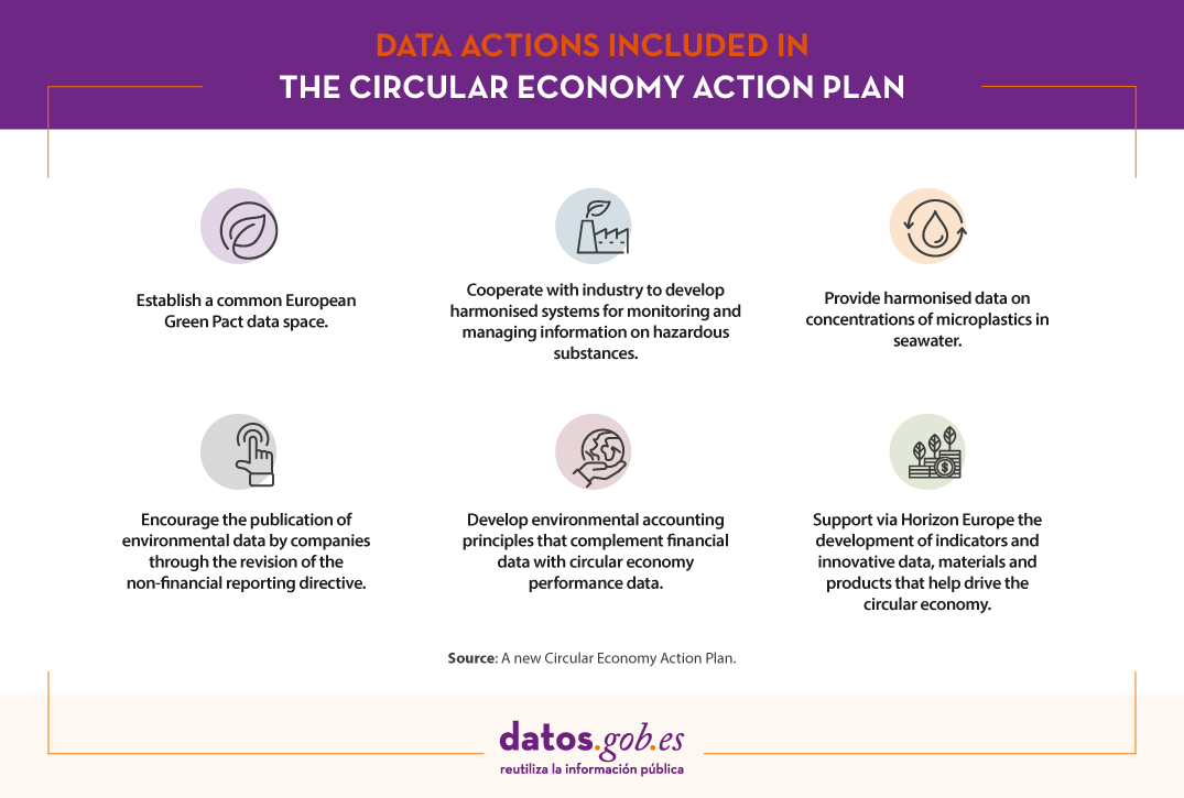
In addition, in order to effectively and efficiently implement the new sustainable products framework, the Commission is pursuing a number of data actions such as:
- Establish a common European Green Pact data space for smart applications with data on value chains and product information.
- Provide harmonised data on concentrations of microplastics in seawater.
- Cooperate with industry to develop harmonised systems for monitoring and managing information on hazardous substances, in synergy with measures under the sustainable product policy framework and the European Chemicals Agency (ECHA).
- Encourage the publication of environmental data by companies through the revision of the non-financial reporting directive.
- Support a business initiative to develop environmental accounting principles that complement financial data with circular economy performance data.
- In addition, Horizon Europe will support the development of indicators and innovative data, materials and products that help drive the circular economy.
In our country, the promotion of the circular economy is marked by the Spanish Circular Economy Strategy 2030 (EEEC), whose objectives for 2030 include reducing waste generation by 15% compared to 2010, improving water use efficiency by 10% and reducing greenhouse gas emissions to below 10 million tonnes of CO2 equivalent.
We live in a context of increasing demand for raw materials and scarcity of resources. Many raw materials are finite and, as the world's population increases, so does demand. The circular economy is therefore a key element for the optimal development of the future of the entire population. Within all the initiatives that are already underway, data can play a key role in increasing our knowledge and driving technologies that help all citizens to move towards a sustainable future.
Content prepared by the datos.gob.es team.
Noticia
Care for the environment is an aspect that has been of concern to a large part of society for several years now. It is clear that we have reached a turning point that makes us see the need to act as soon as possible to avoid further damaging our planet. Therefore, we citizens must change our habits if we want to see a real change in this situation.
Recently we have seen how the new generations are the ones who are most aware of the need to take proper care of the environment at a global level. At this point, change becomes more than necessary and new technologies can play a fundamental role in helping us to take care of our planet.
Did you know that open data is very useful in overcoming environmental challenges? In addition to providing us with accurate information to understand the problem and to be able to search for effective solutions, open data allows us to implement solutions that raise awareness in society and make it easier for us to protect the environment.
Currently, in our portal you can find diverse content on applications related to the environment, cases of use of open data to fight climate change, in addition to 6,000 datasets related to this field.
Below, we highlight some of the environmental datasets that you can find in our catalogue to reuse and develop new applications and services that can drive improvements in this field.
These are the types of environment-related data you can find at datos.gob.es
In our portal you can find a wide catalogue of data classified by different sectors. The Environment category has different datasets that can help in the fight against climate change, deforestation or environmental degradation, threats faced by the whole world.
Of these datasets, the following are the most important ones, together with the format in which you can consult them:
-
At the state level
- Centre for Sociological Research (CIS). Ecology and environment. ASCII.
- Ministry of the Interior. Nature conservation: environment-related offences. XLSX.
- National Parks Autonomous Agency. Natural systems in national parks. SHP, HTML.
- Confederación Hidrográfica del Guadalquivir. Distribution of invasive species in the Guadalquivir river basin. HTML, WFS, WMS, SHP, KMZ.
- Renfe – Operator. Main sustainability indicators. XML, JSON, CSV, TURTLE, RDF.
- INE. Statistics on Waste Collection and Treatment. CSV, XLSX.
-
At Autonomous Community level
- Xunta of Galicia. Air quality data. XLS, JSON, RSS.
- Basque Government. Cartography of the Open Catalogue of Relevant Natural Spaces. SHP, WMS.
- Castilla y Leon Government. Camping area in natural spaces. GML, SHP, KML, CSV.
- Government of Aragon. Special Conservation Areas de Especial. JSON, CSV, KMZ, SHP, GML, XML-APP.
- Autonomous Community of Madrid. Reforestation. JSON, CSV.
-
A the local level
- Santander City Council. Environmental News. RDF-XML, XML-APP, JSON, RDF, CSV, Atom, RDF-Turtle, HTML, RSS.
- Cáceres City Council. Cáceres rubbish collection points. SPARQL, RDF-Turtle, CSV, XLS, JSON.
- Valencia City Council. Location of domestic oil containers. WMS, KML, GML, WFS, KMZ, OCTET-STREAM, JSON, CSV.
- Vigo City Council. Forest Parks (Points of Tourist Interest). CSV, JSON, KML, ZIP, XLS, CSV.
- Alcobendas City Council. Environment. Waste collection. ODS, XLS, XML, CSV, JSON.
- Madrid City Council. Clean Proximity Points. RSS, XLS, CSV.
Some examples of environmental data reuse
The power of datasets related to this field is of tremendous value. Thanks to them, it is possible to create new tools that facilitate aspects such as the care of the environment or the fight against climate change. An example of this is the National Air Quality Index, which makes it possible to check, in real time and in a simple way, the state of the air quality marked by the 506 measurement stations of the national monitoring network. Or Förecast, an application with real-time data on forest stocks that allows spatial-temporal analysis and thus optimises forest management.
Do you know of any company that uses this type of data or an application that relies on it to help care for the environment? Then do not hesitate to leave us a comment with all the information or send us an email to contacto@datos.gob.es. We will be happy to read you!
Noticia
We are currently in a context of digital transformation in which all sectors are in a process of adaptation with the aim of responding to the needs for improvement, agility and efficiency that society demands. One of the fields in which this change is most evident is the rural environment.
In the specific case of Spain, the change of paradigm is more than necessary due to aspects such as climate change or the depopulation of rural areas. The digital transformation of primary activities such as agriculture or livestock farming can contribute to solving these challenges, by attracting new professional profiles to areas with lower population density, and contribute to more efficient and sustainable crops.
Open data play an important role in solving these challenges through digital transformation, as the raw material for technological solutions that help to make better, more sustainable decisions. For this reason, we would like to tell you about the main rural environment datasets that you can find in our catalogue and reuse to implement applications and services that promote improvements in this sector.
What types of data related to the rural environment can I find in datos.gob.es?
In datos.gob.es we have a wide catalogue of data related to different sectors such as Tourism, Environment, Culture and Leisure, Economy, Transport, Health or Industry. The Rural Environment category includes different data catalogues related to Agriculture, Livestock, Fisheries and Forestry.
Currently, this category has more than 1,000 outstanding datasets. Among these datasets we can find national, as well as local and regional information. In this article, we have already talked about the datasets that the Ministry of Agriculture, Fisheries and Food made available to citizens, but there are many more in this category. Along with the ministries, the institutions that most publish this type of dataset are the Autonomous Community of the Basque Country, the Government of Catalonia and the National Institute of Statistics (INE).
Of these datasets, the following are the most important, together with the format in which they are offered:
-
At state level
- CIS. Spanish rural youth. XML, CSV, Json.
- Official INSPIRE Data and Services Catalog. Beach guide. MDB, KMZ, SHP, ASCII, XHTML.
- INE. Distribution of certified organic farming area qualified and or in conversion period. CSV, XLSx, XLS, Html, Json, PC-axis.
-
At Autonomous Community level
- Government of Catalonia. Agro-food industries in Catalonia. CSV, JSON, XML-APP, RDF-XML.
- Castilla y León Government. Agricultural statistics (Castilla y León). CSV.
- Government of Aragon. Agricultural regions of Aragon. CSV, XML-APP, JSON.
- Basque Government. Rural women in the Basque Autonomous Community by professional situation according to age group (%). CSV, XLS.
- Autonomous Community of Castilla-La Mancha. Agricultural training courses. XLSX, PDF.
-
A the local level
- Island Council of La Palma. Zoning and uses of the island of La Palma. HTML, CSV, JSON, GeoJSON, KML, SHP.
- Barcelona Provincial Council. Decline of the forest mass of the Maresme forests. PDF, ZIP, HTML.
- Vitoria-Gasteiz City Council. Risk of forest fires.PDF, OCTET-STREAM.
- Zaragoza City Council. Zaragoza City Hall Clean Points. GeoRSS.
The re-use of data from the agri-food, forestry and rural sectors
The reusable power of all these data sets is very valuable. They can be used to create valuable tools and services. Take the example of the Agricultural Plot Geographic Information System, SIGPAC, which "makes it possible to identify geographically the plots declared by farmers and stockbreeders, in any aid scheme related to the area cultivated or used by the livestock". This viewer was created to make it easier for farmers to submit aid applications and to monitor them. However, it should be noted that SIGPAC has also been used to develop applications and services that improve crop efficiency, such as Campogest or Cropti. Many of these applications also incorporate the data from the Register of Fertiliser Products, such as cultivAPP, which allows farmers to control the phytosanitary treatments applied in an easier way, from their own mobile device.
We can also find applications related to the forestry field, such as förecast, a tool that provides real-time data on forest stocks and allows for spatial-temporal analysis based on remote sensors and artificial intelligence. Or with a marked social character such as Plan Repuebla, a project that seeks to reactivate the rural areas of Castile and Leon.
You can see more examples of the reuse of agricultural data in the finalists of the 2019 Challenge, in our applications section or in this report.
From datos.gob.es we invite you to visit our data catalogue and discover all the datasets we have collected in the different sections.
Entrevista
Now that the call for the third edition of the Aporta Challenge is open, in this occasion focused on the field of education, we have talked to the winner of the 2019 edition, Mariano Nieves, who won thanks to his Optimacis solution. Mariano explained his experience and gave us some advice for this year's participants.
Full interview:
1. What does Optimacis consist of?
Optimacis is a project for the optimisation of the fresh fish market, which seeks to balance prices against monopsony situations.
The success of the project lies in the delivery of value for the three main actors in these markets:
- the fishing companies as producers
- wholesalers and hospitality companies as mediators in the delivery to the market;
- and the fish markets themselves as primary distribution centres.
The values for each actor are specific: in the case of fishermen, by means of advance knowledge of the most advantageous prices for sale; in the case of wholesalers and restaurateurs, by means of knowledge of the supply points with the greatest capacity; and in the case of fish markets, by means of advance knowledge of the expected influx into their facilities, for the internal organisation of resources.
2. What prompted you to participate in the Aporta Challenge?
Without a doubt, the institutional support of datos.gob.es is a reference in the Public Administration, given that the project has a marked character of sustainability for a group that usually requires additional resources to the exploitation.
It was not a preconceived project that came to take advantage of the call. On the contrary, the project was developed after reading the call for proposals. In all honesty, I even asked a formal question at the Red.es website to make sure that fishing was an area covered by the 2019 Aporta Challenge.
I thought that having the recognition and dissemination of the Aporta Challenge would boost my professional career, as it has. This is a value that I want to highlight to encourage other participants in the new call: there are currently many professionals with an impressive career, who can make their CV shine with success in the Aporta Challenge.
3. How was your experience?
The challenge was impressive. For those who know the exciting world of data, I think it is important to stress the importance of handling more than 3,500 predictive models in real time (well, with a 24-hour regeneration cycle).
This is supported by various sources of ingestion, highlighting the information from Meteogalicia and the State Agency of Meteorology, the ingestion in real time from two radar systems (actually, they are called Automatic Identification Systems) located in As Pontes de García Rodríguez and Vigo, and the daily extraction of the price data published from the Galician fish markets.
Shuffling all these sources of information in record time (with seven machines working in continuous mode 24x7), ingesting and monitoring the predictive models was a major effort for me, to which I dedicated the entire summer of 2019. And the months of September and October was dedicated to geolocation and machine learning tasks.
The main advantage that the challenge has given me has been to know sources of large masses of data that are available for projects of all kinds, with the solvency of the sources of the Public Administration.
4. What is the current status of the development of the Optimacis System?
We are already in a phase of promoting the solution, in order to coordinate with public bodies that promote sustainable projects in the field of fisheries at a state, local and regional level. The balance of the market conditions is being a factor that awakens interest in local administrations.
5. What advice would you give to participants in the Aporta 2020 Challenge?
Well, only from my partition experience of course. I think that the dedication and effort were decisive in my case, because the rest of the participants had a very high level to which I could not aspire. Most of them were groups of people, while my participation was of a personal nature. However, the fact that I was able to build this whole block of predictive models and carefully review the results was decisive.
On the other hand, I think it also helped that I took meticulous care of the presentation. The fact that I carefully wrapped the content was well appreciated, as I had a fully functional model.
6. Closing and farewell.
I want to convey all the encouragement to the participants of this call, and not hesitate to include dedication and effort because it is worth it. Not every day you receive recognition from a government institution like datos.gob.es. May the best one win!
Evento
The European Commission has already published the official call for entries for the European Green Leaf 2022 (EGLA) and European Green Capital 2023 (EGCA) awards, which aim to recognise the progress made by cities committed to sustainability.
This year, the deadline for submissions will remain open until 28 October and the financial allocation for both awards will be up to one million euros combined, to support cities in effectively implementing new urban sustainability measures. This increase in the prize money aims to raise awareness of the objectives of the European Green Deal.
Prize money and benefits
The two winning municipalities or cities of the European Green Leaf 2022 award will each receive 200,000 euros, while the winning city of the European Green Capital 2023 call will receive 600,000 euros. The main objective of both grants is to make the winning cities take on new responsibilities in the fields of sustainability and environment.
In addition to the economic award, the winners of both prizes will have a seal of approval from the European Commission that will allow them to enjoy benefits such as increased media coverage at an international level, as well as receiving a greater focus on environmental projects and foreign investment.
Furthermore, not only the winning cities or municipalities will benefit, as the finalist cities will have access to a knowledge network that already includes the most outstanding candidates from previous years, where they can share knowledge about how to learn to overcome new key challenges in terms of sustainability.
Deadlines and requirements for submission of applications
The European Green Leaf 2022 awards are aimed at municipalities with a population of between 20,000 and 99,999 inhabitants, with a maximum of two population centres to be awarded. On the other hand, the European Green Capital 2023 award remains open to cities with a population of more than 100,000 inhabitants.
The 28th of October 2020 at 23:59 (CET) is the date and time limit for all nominations to be submitted to both awards. All information on how to register, the rules and legal bases, as well as the participation process, can be found on the official website.
La importancia de los datos abiertos en las smart cities
When we talk about open data in smart cities we refer to a basic concept to understand the development of smart cities and the processes of active participation of citizens.
In an increasingly digital society, the importance of data processing and management is essential for companies and administrations. In this sense, smart cities are not an exception, as they represent an important opportunity to check the usefulness of this information to promote new ways of citizen participation in smart cities, to boost informed decision-making and to improve the efficiency of public services.
Noticia
Last December the European Data Portal published a new report entitled Analytical Report 14: Enabling Smart Rural: The Open Data Gap, which examines the collection, availability and use of open data in rural areas.
27% of the citizens of the European Union live in rural areas where it is not easy to implement the same processes, technologies and activities that are driving the cities transformation. In a European context where smart cities are being promoting, the report focuses on the differences and synergies between rural and urban areas in terms of opening and reusing open data. To this end, the available resources have been analysed and 6 respondents have been interviewed: 3 experts from national portals in rural countries (Ireland, Romania and Slovenia) and 3 experts in agriculture, fisheries and the forestry sector.
Availability and reuse of rural data
The first part of the report focuses on knowing the availability of rural data, focusing on two categories of data:
- Rural population data: data relating to people living and working in rural areas, such as the availability of housing, connectivity, access to transport, demographic profile, employment levels or public services access, among others.
- Rural sectors data: Data related to the main sectors of the rural economy, that is, agriculture, fisheries and the forestry sector.
The conclusion reached by the report is that there is more open data from the second category (rural sectors), than from the first (rural population). Specifically, almost 14% (13.75%) of all EDP data sets are agricultural data.
Many of the challenges that public agencies face when opening data in rural areas are the same challenges they face in cities, such as lack of awareness or standardization. However, other aspects such as the digital gap or technological capabilities gaps (worse broadband connection, fewer devices ...) also influence
With regard to reuse, the report highlights the great potential of rural open data to generate economic and social benefits through several examples and success stories, such as increasing transparency in the agricultural products market. As before, the reuse of data related to rural sectors is higher than the reuse of data related to the rural population.
The report also highlights that the majority of rural data reuser and companies are located in urban areas, where awareness of the benefits of this type of data and its possible uses is higher.
Recommendations to boost the opening and reuse of rural data
The report ends with a series of recommendations for member state governments to promote the publication and use of data at the rural level. These recommendations are structured around 3 areas:
- Data collection
- It is necessary to establish and institutionalize open data processes and practices in rural administrations, with close relationships to urban open data groups
- The report recommends paying attention to high-value agricultural datasets, because there is currently a a gap between their agricultural percentage of GDP and their open agricultural datasets.
- Data opening
- Collaboration links must be established with complementary data owners, such as non-profit organizations, researchers or private organizations, that allow data to be opened and made available together.
- The report highlights the term Smart regions, covering both smart cities and nearby rural areas, to generate synergies, and recommends investing in understanding the key factors of smart regions that mean they are more fit for purpose.
- Data reuse
- It is necessary to establish links with urban areas, through instruments such as study centres or universities.
- Finally, the report recommends to identify the rural-specific challenges, such as out-migration, health solutions that address distance, and food provenance.
The report concludes by highlighting the need to institutionalize the commitment to open data and foster the skills necessary for the publication and use of open data on both the population and the rural sectors, so that they are not involuntarily excluded from the benefits of data economy.
Blog
Humans have been interested in weather prediction for several millennia. This interest goes back at least until the Babylonian civilization, when meteorological predictions were already made based on astrology and the clouds patterns. However, it was in the early twentieth century when decisive progress was made thanks to the understanding of physical laws that govern climate and predictions based on numerical models. From that moment on, mathematical models constructed from data collected by weather stations are still the basis of current weather prediction forms.
In the last decade, important advances have been made in the accuracy of short-term predictions of weather conditions in increasingly local environments. These improvements come largely from the ability to collect and process more and better data in real time with autonomous weather stations, to the important advances in data processing capacity thanks to cloud computing and the advances in data science and big data techniques. And, as we know, artificial intelligence and predictive models are better when higher is data quality.
The opening of climatic data
From the second half of the nineteenth century, states began to establish national meteorological services, in charge of the collection, generation, verification, interpretation and application of climate data. The first one was in United Kingdom in 1854 (now Met Office) and the Spanish Meteorological Agency (AEMET) is heiress of the service founded in 1887.
According to the Open Data Charter, nowadays almost all countries have a network of weather stations to collect local weather data, but there are important differences in their capabilities. For example, in some countries there is a network of high-density automated weather stations and measurement files that include long time series and local weather models. In other countries, however, a limited number of weather stations that are, in general, manually managed, with irregularly stored data, are available.
In any case, the value of the data collected and the models developed by these agencies is enormous for critical decision making in many industries. Therefore, its consideration as public sector information and its release as open data has been limited by important economic interests. The open data community is playing a very important role in making these data available to the public in the least restrictive conditions possible.
In general, meteorological data are usually available for reuse under license, with some data sets available with free access and other data sets only available for commercial use. Meteorological data sharing depends to a large extent on local policies for access and data sharing. The Open Data Charter still recognizes that there are difficulties for data sharing, because in many countries local meteorological observations are considered a commercial or strategic asset.
In Spain, the Aemet OpenData service allows two types of access: general access consisting of a graphical access for general public and Aemet OpenData API, designed for periodic or scheduled interactions with applications that require the available data sets. Both allow access to the same data catalog in reusable formats.
The reuse of climate data
Weather forecasts are of high importance in many industries, but are also useful for the general public. Therefore, the communication of these predictions also has a long tradition in formats that are not only data and models. Already in 1861 the first daily weather predictions were published in the British newspaper “The Times” and in 1936 the BBC experimentally broadcast the world's first televised weather predictions, including the use of weather maps. While these ways of communicating the predictions to the general public continue today, if there is an application that we could find in almost all smartphones in the world, it is the weather forecast app.
Pew Research, in its report “Americans’ Views on Open Government Data” 2015, already showed the widespread use of weather information apps, publishing that at least 84% of Americans with a smartphone had used them to consult the local weather forecast. Since these applications use data from the national meteorological service of the United States Government, the report concludes that, although unaware, 84% of Americans with a smartphone use regularly open public data.
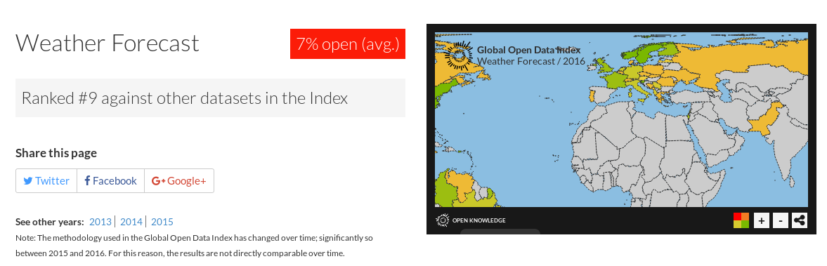
The importance of climate-related data sets prepared by national meteorological services is reflected in the fact that they tend to be one of the data sets that international open data indices consider key in their different measurement methodologies. For example, the Global Open Data Index (GODI) prepared by the Open Knowledge Foundation considers meteorological predictions as one of the 15 data sets that it includes in its measurement, at the same level as national statistics or commercial register data. In the 2016 edition, this data set was the ninth with the best score, 35% in the average opening metric.
The OURData Index, prepared by the OECD, uses 9 data sets to analyse the situation of open data in the 28 OECD countries and one of them is meteorological information.
The value generated by the reuse of meteorological data is extraordinary in areas as diverse as air traffic control, the precision agricultural and forestry industry or maritime navigation. One of the most obvious demonstrations is in the purchase of the company The Climate Corporation by Monsanto in 2009, which amounted to more than 900 million dollars the value created from open data mainly related to geology and meteorology.
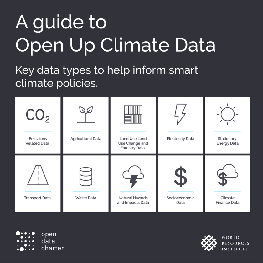
Meteorological data is also one of the key data sets in initiatives to combat climate change and the design of sustainable environmental policies. Therefore, they are present as fundamental assets in initiatives such as the “Open Up Climate Data: Using Open Data to Advance Climate Action” by the World Resources Institute and the Open Data Charter, the challenge “Data for climate action” by Nations United or the Copernicus Climate Change Service (C3S) by the European Commission.
But, the high transversality of the meteorological data means that the most surprising uses are still beginning to develop, from forensic meteorology to help the resolution of crimes, to the prevention of asthma attacks or the improvement of marketing actions from the relationship between the weather and consumer behaviours. The development of open data policies as restrictive as possible that put meteorological data in the hands of innovators and researchers is essential so that these and many other applications can see the light.
Content prepared by Jose Luis Marín, Head of Corporate Technology Startegy en MADISON MK and Euroalert CEO.
Contents and points of view expressed in this publication are the exclusive responsibility of its author.
Noticia
According to World Bank data, agriculture is one of the main economic sectors in the world, with an added value of more than three trillion dollars. But its importance goes much further. Sustainable agriculture, in addition to generating wealth, can help overcome many of the challenges that humanity faces, such as the fight against hunger, climate change or biodiversity conservation.
In this context, access to data related to agriculture and food is essential. Agricultural data facilitate informed decision making, and the development of policies that help overcome the challenges mentioned above. Therefore, many international organizations, such as GODAN, or private companies, such as Syngenta, are promoting this type of information sharing.
In our country, the main agency that is boosting the opening and dissemination of agricultural and environmental data at the state level is the Ministry of Agriculture, Fisheries and Food, known as MAPA (in its Spanish acronyms).
The MAPA provides updated information on agricultural, fisheries and livestock markets, forestry or rural development policies, the evolution of the agri-food industry, etc. In addition, it provides cartographies and geographic information of high utility, such as the Agricultural Plots Geographical Information System, which allows the identification of parcels declared by farmers and ranchers.
This Ministry also has a series of attached agencies that also generate and share their own data, focused on specific areas, such as the Food Chain Information and Control Agency (AICA), the National Agency for Agricultural Insurance (ENESA) and the Spanish Agricultural Guarantee Fund (FEGA). Many of the data sets that the MAPA and these agencies provide are federated with data.gob.es.
Among the many datasets we can find, the most visited by users are:
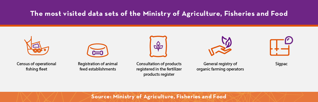
You can access these data sets through the following links:
- Census of operational fishing fleet
- Registration of animal feed establishments
- Consultation of products registered in the fertilizer products register
- General registry of organic farming operators
- Sigpac
These data sets, in addition to informing about the evolution of agricultural, livestock and fishery resources, facilitating transparency, can serve as a basis for creating products and services that add value to the economy and society. The Ministry of Agriculture, Fisheries and Food has contributed in this regard with the development of visualizations and applications that facilitate access to data for specific purposes. An example is SIAR, whose objective is to quickly and easily manage the irrigation program of a plot, with the consequent improvement in efficiency, sustainability and resource savings. The application uses data from the measuring stations of the Agroclimatic Information System for Irrigation, accessible through this portal. Another example is Natural Roads, which shows some of the routes included in the Natural Roads Network of Spain.
But not only the Ministry of Agriculture, Fisheries and Food has created applications based on its data. Thanks to the fact that the information is in open and accessible formats, companies and individuals have been able to create services such as CultivAPp, Fitosanitarios o Cropti, which help to manage farms in a more efficient and sustainable way.
Properly managing our resources is essential to guarantee the future of humanity. Therefore, more and more autonomous governments and private accelerators are committed to promoting innovation in the sector, an innovation that is closely linked to the use of new data-based technologies, such as Big data, IoT or Artificial Intelligence. The analysis of the information provided by the Ministry of Agriculture, Fisheries and Food allows enriching these technologies and improving production in a sustainable way, contributing to development.
Application
RuralMaps facilita la gestión de emergencias proporcionando información a través de mapas dinámicos que se adaptan a la situación del terreno.
La aplicación permite acceder a la red completa de caminos rurales y pistas forestales, y calcular la ruta óptima para alcanzar un destino en un momento determinado. Para ello, tiene en cuenta los eventos que se estén produciendo (incendios, inundaciones, etc.) y proporciona rutas alternativas que puede suponer un ahorro de recursos y de tiempo, algo vital en caso de emergencia.
RuralMaps puede ser de gran utilidad para los técnicos agrícolas y para los servicios de emergencia, como la policía, los bomberos o la guardia civil, que a veces tienen que alcanzar un destino sin conocer bien la situación del terreno, pero también puede ser utilizada por otros públicos en situaciones de normalidad. Entre sus usuarios también se encuentran, por ejemplo, turistas, que quieren conocer nuevas rutas para realizar senderismo o BTT.
Esta aplicación ha sido desarrollada por remOT Technologies, una empresa española nacida en torno a la actividad investigadora del grupo Geoforest-IUCA de la Universidad de Zaragoza. Para ello han utilizado datos abiertos procedentes del Instituto Geográfico Nacional.