Logo
Commerce
Culture and leisure
Demography
Sport
Economy
Education
Employment
Energy
Treasury
Industry
Environment
Rural Environment
Healthcare
Public sector
Society and welfare
Transport
Tourism
Town planning and infrastructures
Housing
Author / Developer:
Imanol Iglesias
Platforms:

Publication date
22/04/2026
Images
Information
Description
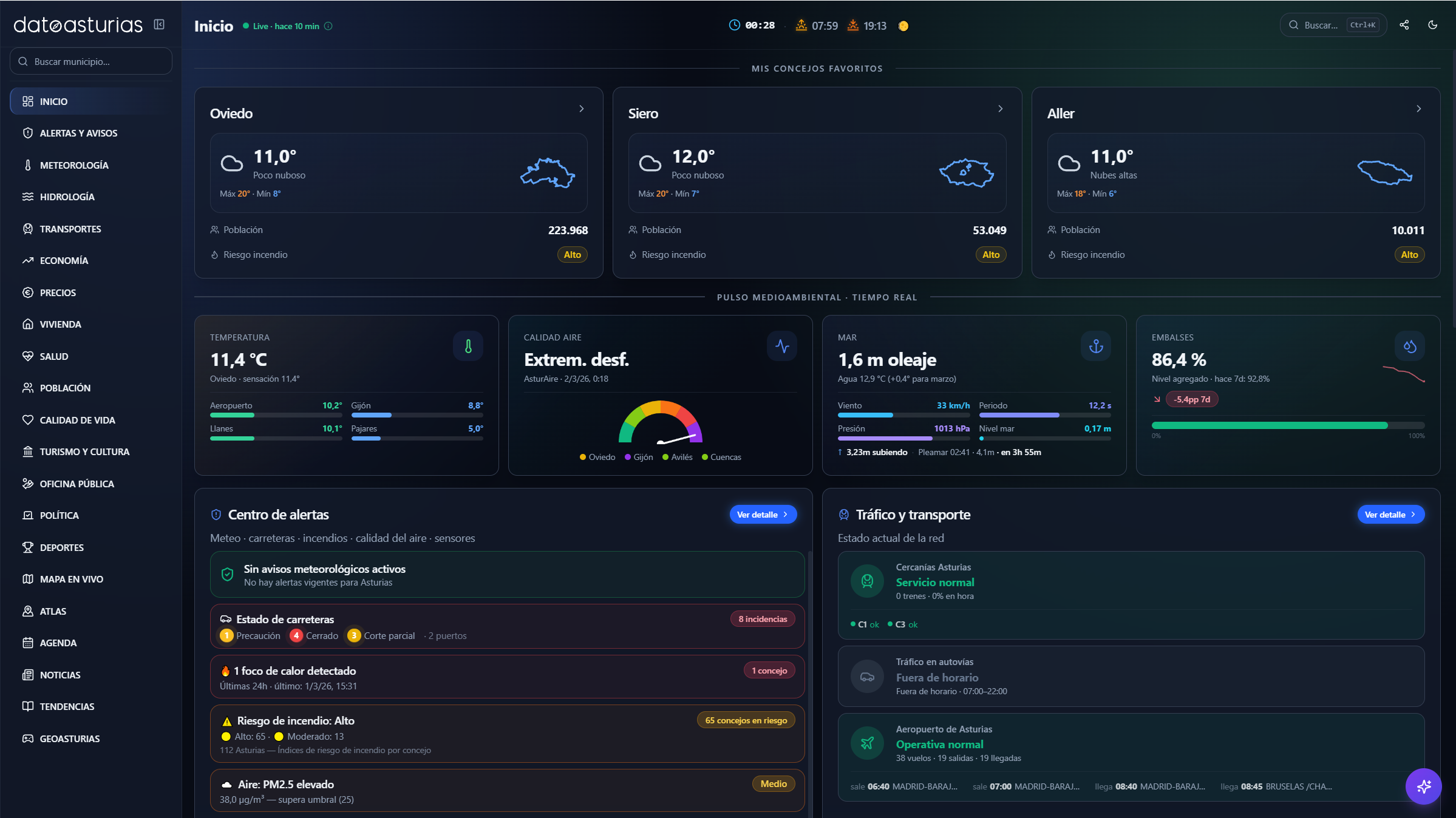
Dato Asturias is a real-time interactive dashboard that offers a complete and up-to-date view of the Principality of Asturias. The platform aggregates more than 30 institutional open data sources into a single visual interface, allowing citizens, researchers, journalists, and administrations to consult the state of the region at a glance.
The system automatically updates its data with different frequencies depending on the source: from 5-minute intervals for weather information to daily updates in economic indicators or weekly updates in health data, thus ensuring continuous access to reliable and recent information.
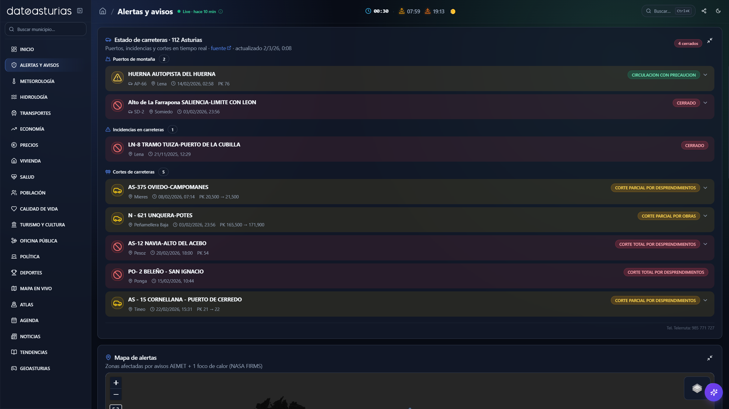
The application integrates a wide set of functionalities organized by thematic areas. In the block of alerts and warnings, it includes active weather warnings (AEMET), heat sources detected by satellite (NASA FIRMS), earthquakes (IGN) and the state of roads and mountain passes (112 Asturias).
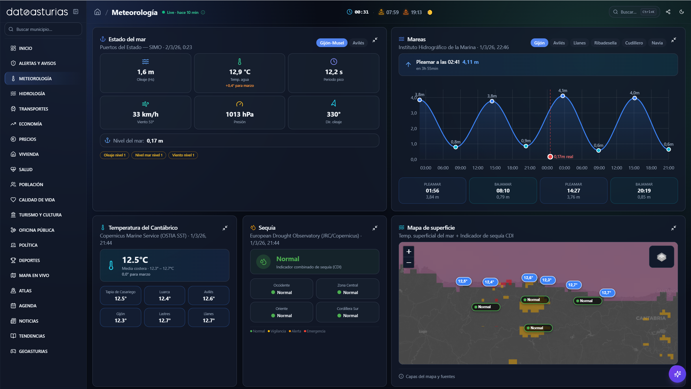
- In meteorology, it offers prediction and observations for the 78 councils, real-time air quality (AsturAire), pollen and pollutant forecasts (Copernicus CAMS), UV index, Saharan haze, sea and tidal conditions (Puertos del Estado), sea surface temperature (Copernicus Marine), ski resort information, Sentinel-2 satellite images and drought monitor (Copernicus Emergency).
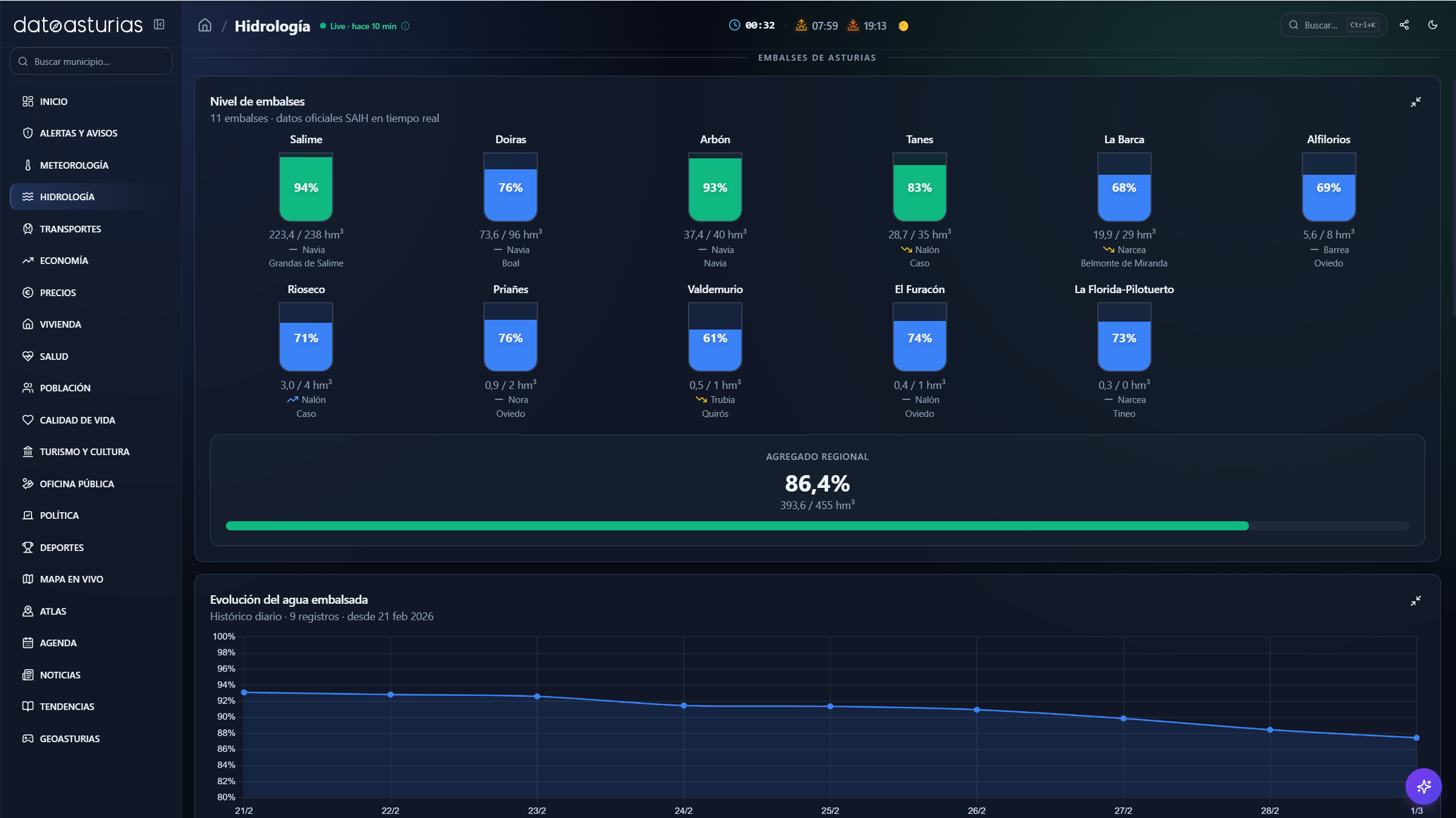
- The hydrology section includes river flow, reservoir levels, rain gauges and real-time data from the Cantabrian SAIH, along with accumulated weekly history and WMS flood risk layers (GloFAS/EFAS).
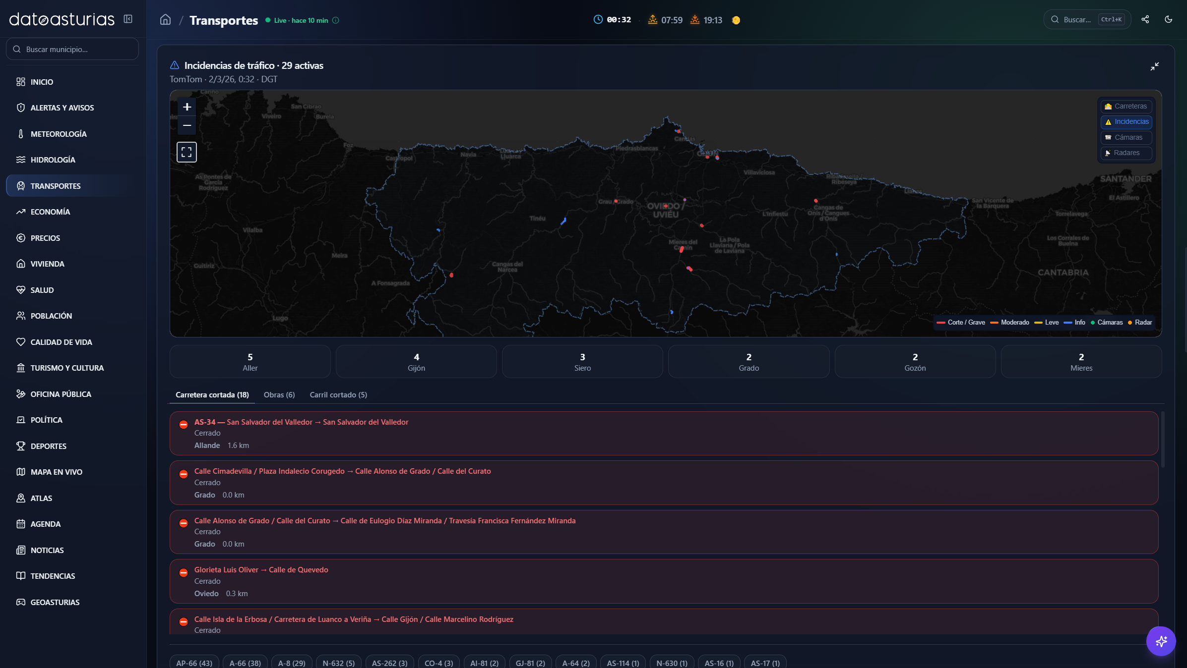
- In transport, schedules and delays are shown in real time for Cercanías Asturias (Renfe GTFS-RT), flights from Asturias airport (AENA), cameras and traffic incidents (DGT, TomTom) and travel times between cities.
- The economy section includes indicators such as GDP, employment, unemployment, affiliation, wages, companies, exports and energy mix (REE), with historical and year-on-year comparative series. In prices, the price of electricity hour by hour (REE/PVPC), fuel at all Asturian petrol stations (Ministry of Energy) and the CPI broken down by groups (INE) are offered.
- The housing block includes house prices by council, mortgages constituted, cadastral data and rental prices by census tract (SERPAVI/MITMA). In health, weekly epidemiological surveillance (flu, COVID-19, RSV, rhinovirus), positivity rates and pharmacies on duty are included.
- In population, indicators such as number of inhabitants, age pyramid, birth rate, mortality, median age, density, urban-rural distribution and foreign population are shown, all by council and with historical evolution. In turn, the quality of life module incorporates its own index based on eight dimensions (prosperity, employment, demography, dynamism, public spending, housing, education and health), with a ranking of the 78 councils and a comparator of up to three municipalities.
- The tourism and culture area offers data on travellers, overnight stays, average stay and type of accommodation, including hostels on the Camino de Santiago, with monthly and year-on-year evolution (INE, SADEI). In public office, subsidies, grants, scholarships (BDNS) and public employment offers are collected filtered for Asturias.
- The political bloc presents electoral results, composition of municipal corporations, mayors and distribution of the vote by council. In sports, they include football classifications (Real Oviedo, Sporting de Gijón), mountain race calendar (FEMPA) and monitoring of the salmon season.
The platform also incorporates a live map with more than 15 superimposed layers (temperature, reservoirs, rivers, air quality, earthquakes, hot spots, DGT cameras, incidents, fire risk, AEMET stations, parishes and points of interest), as well as a geographical atlas with 57,000 toponyms from the Basic Geographical Gazetteer of Spain, filterable and represented on an interactive map.
Among its additional functionalities are an agenda of cultural and festive events, an institutional and regional news module, a trending section based on visits to Wikipedia, the daily game GeoAsturias for geographical recognition, and detailed council files that integrate all the information available at the municipal level.
To offer these services, the application relies mainly on institutional open data sources, including AEMET, INE, SADEI, Red Eléctrica de España, IGN, DGT, Cantabrian Hydrographic Confederation, NASA FIRMS, Copernicus (CAMS, Marine, EFAS, Emergency), Puertos del Estado, AENA, Renfe, 112 Asturias, AsturAire and the Ministry of Energy, among others.