
Description
Every time an asthmatic person checks the level of suspended particles before going for a run, or when a city council decides to close a playground due to a pollution episode, there is open data behind that decision. Open environmental and climate data – on air quality, water, biodiversity or extreme events – are no longer the exclusive preserve of scientists and institutions and have become a global civic infrastructure: accessible, reusable and, increasingly, generated by citizens themselves.
The question is no longer whether this data exists. They exist and in unprecedented quantities. The question is: who uses them and for what? This article covers this ecosystem of information, from global platforms to local repositories, including citizen projects that have transformed our environment.
The citizen turn: from consumers to data producers
For decades, environmental data came mainly from state agencies, government satellites, and large laboratories. That panorama began to transform when sensors became cheaper, smartphones became massive, and organized communities understood that measuring their environment was also a way to protect themselves and their surroundings. In this way, the information generated by citizens is added to that of public bodies, expanding and enriching the collective understanding of the environment. Some examples are:
- iNaturalist, the citizen science platform for documenting biodiversity, accumulates more than 200 million observations, made by 3.3 million participants worldwide. Its data, integrated into GBIF (Global Biodiversity Information Facility), is used in conservation research, in monitoring the impacts of climate change and in biodiversity policies in dozens of countries.
- IQAir AirVisual is another global air quality network, with more than 30,000 stations and real-time data from more than 100 countries, including maps, 7-day forecasts, and recommendations for vulnerable groups.
- NASA's GLOBE Observer has been allowing anyone to record observations of clouds, temperature, ground cover and mosquito habitats from their mobile phone since 2016 – a critical indicator for detecting pockets of vector-borne diseases aggravated by global warming.
- Meteoclimatic is a collaborative network of automatic weather stations that share data in real time, focused on the Iberian Peninsula and nearby areas.
These projects show that citizens no longer only consume data: they also produce it, validate it and make it available to the public.
Cases that change policies: from citizen data to public decision
One of the most persistent prejudices about citizen science is that its data is too imprecise to have a real impact or even to be considered science. Several recent projects challenge that argument and are pushing for the belief to change.
The European COMPAIR project, funded by the Horizon Europe programme between 2021 and 2024, deployed citizen air quality sensors in five cities: Athens, Berlin, Flanders, Plovdiv and Sofia. Citizen sensors are low-cost environmental measurement devices (air, noise, temperature, water, etc.) that citizens themselves install, maintain and use to generate open data on their immediate environment. These sensors were installed in neighbourhoods and spaces used by Roma communities, the elderly and schoolchildren. This choice aimed to make visible exposures to risk that are usually off the radar (for example, school routes with heavy traffic or insufficiently monitored peripheral neighborhoods) and to provide additional data that would allow administrations to design measures aimed at those who breathe the most polluted air. In Sofia, for example, the publication of pollution maps at school entrances led to a documented increase in the use of public school transport; a citizen data project that changed collective behavior.
Citizen data, moreover, when it respects methodological and legal conditions, can be admissible before the courts and contribute to policy improvement. It is precisely this type of use that is being developed by the Sensing for Justice (SensJus) project: a Marie Curie initiative – a prestigious European research funding programme – that uses networks of citizen sensors as evidence in environmental litigation and out-of-court mediations, with success stories documented in the United States and Italy.
Projects located in closer contexts
Environmental or climate data activism is not a distant phenomenon. Spain has a growing network of initiatives that take environmental measurement to the scale of the neighbourhood, river and roof.
Smart Citizen, created by the Barcelona Fab Lab of the Institute for Advanced Architecture of Catalonia (IAAC), is one of the world's leading projects in citizen sensing: it combines a low-cost sensor kit – air quality, temperature, humidity, noise, light – with an open real-time data platform. With more than 9,000 registered users and more than 1,900 sensors deployed in more than 40 countries, it demonstrates that citizen environmental monitoring can have a global reach based on a local initiative. SensaCitizens, on the other hand, is a Spanish network of low-cost environmental monitors, with LoRaWAN technology, aimed at generating useful data for local public policies on air quality and urban comfort.
In the field of everyday health, Planttes stands out, an app developed by the Autonomous University of Barcelona that allows citizens to map in real time the allergenic plants in their environment and indicate their phenological state. The result is a street-level allergy risk map that complements the official pollen information.
River surveillance, on the other hand, is manifested in the Cantabria Rivers Project, active since 2008, which involves volunteers who adopt river sections of about 500 meters and carry out biannual inspections to monitor the ecological status of the river. With 282 sections inspected and more than 300 documented actions, its data feeds the Administration's decisions on ecosystem conservation.
In the urban area there are also various initiatives. Vitoria-Gasteiz participated in the European CITI-SENSE project – together with eight other cities, such as Barcelona, Oslo and Vienna – with a specific initiative for the participatory design of public spaces, which combined noise, air quality and thermal comfort sensors. In total, the project generated more than 9.4 million observations in the participating cities.
At the citizen and local level, the recently presented SolData Spain (Universidad Autónoma de Madrid) offers an open-access geoportal to analyse the evolution of solar energy in Spain over almost three decades, by cross-referencing satellite irradiation data with historical meteorological records.
The following chart summarizes the projects mentioned so far:
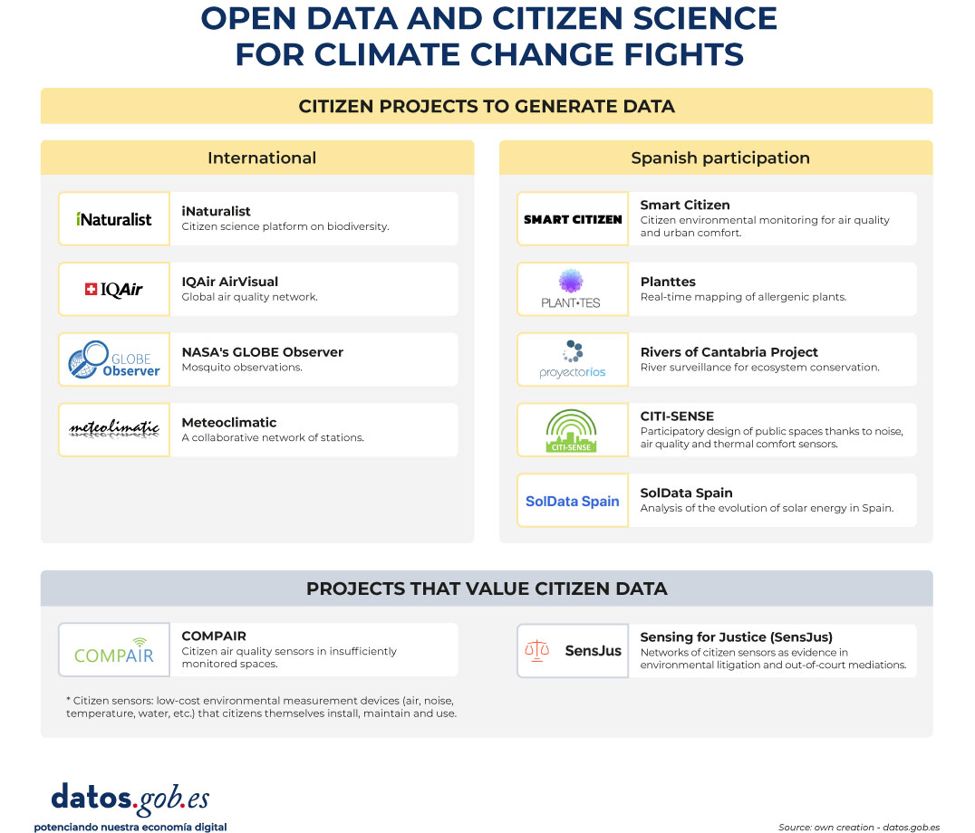
Figure 1. Open data and citizen science for climate and change fights. Source: own elaboration - datos.gob.es
The company is also taking action: climate adaptation with open data
The climate crisis is not only an environmental and social issue, but also an operational risk for businesses. According to the Smart Electric Power Alliance's Utility Transformation Profile report (2023), 62% of the utilities surveyed have developed a public carbon reduction plan (mitigation), but climate adaptation measures remain scarce and rarely quantified. However, we find some examples:
Meteoflow, from Iberdrola, is a weather forecasting platform, recognised by the International Research Centre on Artificial Intelligence (IRCAI) linked to UNESCO, among the best AI projects for sustainability. Its function is to optimise the production of its wind and solar farms by anticipating weather conditions, although it also incorporates alert modules for extreme phenomena that allow it to manage risks. To do this, it uses open-access meteorological information together with its own data, both historical and production in real time.
Another example is dotGIS's Solarmap, which combines open data from cartography (CNIG/INSPIRE), solar radiation (AEMET/Copernicus) and geospatial big data to calculate the profitability per roof of installing solar panels anywhere in Spain.
These are initiatives that have an impact on the operational resilience of companies and a potential benefit for the collective energy system, but whose transformative scope grows when their results transcend the logic of protecting corporate assets to be integrated into shared public infrastructure. In the private sector, data (open or not) can help reduce collective risks—such as avoiding blackouts or anticipating impacts on ecosystems—so its impact is not limited to protecting corporate assets. Its civic potential is multiplied when the results, methodologies and datasets that can be accessed are integrated into data infrastructures shared with other public and social actors.
Where we're headed: three trends redefining security
The landscape of open environmental and climate data is changing, and three trends are on the near horizon.
- From mitigation to adaptation. For years, climate policy focused on reducing emissions. That focus is shifting to adaptation: anticipating risks, reducing vulnerabilities, and protecting communities from irreversible changes. The Basque Country is an example of this turn: the Basque Country Climate Change Strategy 2050 (KLIMA 2050) establishes adaptation as a cross-cutting axis with objectives by sector – health, water, biodiversity, energy – and Vitoria-Gasteiz leads commitments within the framework of the European Mission for Climate Neutral Cities. The leap is also an advance in open data: in addition to measuring and publishing open data on emissions, adaptation strategies are beginning to open and document data on vulnerabilities (heatwaves, floods, public health) and institutional and community response capacities, so that they can be reused by administrations, companies and citizens.
- Citizenship as a civic sentinel. Citizens increasingly act as civic sentinels: they collect, contrast and share environmental data that complement official measurements. When a city's neighborhood detects pollution levels that official stations don't record, or when an indigenous community documents changes in its ecosystem that satellites don't capture, a second layer of information critical to risk management is generated. Projects such as OpenTEK/LICCI of the ICTA-UAB integrate indigenous knowledge from Nepal, Thailand, Vietnam and Latin American countries as scientifically legitimate sources of data on climate variability, and make them available under FAIR and CARE principles, seeking to make them as open and reusable as possible without compromising the sovereignty of the communities that generate them.
- FAIR standards and European data spaces. The European Union promotes the Green Deal Data Space and the AD4GD initiative to integrate open environmental data under FAIR (findable, accessible, interoperable, reusable) standards, which facilitate its combined use by multiple actors. In this framework, the EU's Strategic Foresight Report 2025 identifies the climate transition and security as the two axes that exert the greatest pressure on Europe, and underlines the need for shared data infrastructures based on these principles to respond with resilience.
Open environmental and climate data is not just a technical issue or an aspiration for bureaucratic transparency. They are, increasingly, a condition for communities to be able to anticipate risks, demand responsibilities and make well-informed collective decisions in the face of the greatest challenge. The infrastructure exists. The citizens who use it, too, so we must continue to promote to ensure that its use is universal and equitable.
Appendix: Where is the data? A practical guide to repositories
For anyone who wants to explore, reuse, or combine open environmental and climate data, the ecosystem of repositories is vast and increasingly accessible. Here is a selection organized by scale:
At European level:
- data.europa.eu: European data catalogue, where you can find, among others, data on air, water, biodiversity, climate and energy, with documented use cases
- Copernicus C3S: historical climate data and projections; essential climate variables.
- Copernicus CAMS: real-time air quality and atmospheric composition data.
- ESA CCI Open Data: essential climate variables on glaciers, sea level, greenhouse gases, etc.
- European Environment Agency (EEA): environmental indicators, climate risk maps, biodiversity and water quality.
- INSPIRE : is the central access point for locating, visualizing and accessing geographic information and harmonized spatial data of the member countries of the European Union.
You can find more repositories of interest in this article 10 climate-related public data repositories.
At the state level:
- datos.gob.es: National open data portal with a section on the environment.
- AEMET OpenData: historical climatological series, real-time weather data, REST API, etc.
- MITECO Open Data: data on air, water and emissions quality.
- IDEE Geoportal: geospatial data and national environmental cartography, among others.
Content produced by Miren Gutiérrez, PhD and researcher at the University of Deusto, an expert in data activism, data justice, data literacy and gender-based disinformation. The content and views expressed in this publication are the sole responsibility of the author.

Comments