Blog
Open data has great potential to transform the way we interact with our cities. As they are available to all citizens, they allow the development of applications and tools that respond to urban challenges such as accessibility, road safety or citizen participation. Facilitating access to this information not only drives innovation, but also contributes to improving the quality of life in urban environments.
This potential becomes even more relevant if we consider the current context. Accelerated urban growth has brought with it new challenges, especially in the area of public health. According to data from the United Nations, it is estimated that by 2050 more than 68% of the world's population will live in cities. Therefore, the design of healthy urban environments is a priority in which open data is consolidated as a key tool: it allows planning more resilient, inclusive and sustainable cities, putting people's well-being at the center of decisions. In this post, we tell you what healthy urban environments are and how open data can help build and maintain them.
What are Healthy Urban Environments? Uses and examples
Healthy urban environments go beyond simply the absence of pollution or noise. According to the World Health Organization (WHO), these spaces must actively promote healthy lifestyles, facilitate physical activity, encourage social interaction, and ensure equitable access to basic services. As established in the Ministry of Health's "Guide to Planning Healthy Cities", these environments are characterized by three key elements:
-
Cities designed for walking: they must be spaces that prioritize pedestrian and cycling mobility, with safe, accessible and comfortable streets that invite active movement.
-
Incorporation of nature: they integrate green areas, blue infrastructure and natural elements that improve air quality, regulate urban temperature and offer spaces for recreation and rest.
-
Meeting and coexistence spaces: they have areas that facilitate social interaction, reduce isolation and strengthen the community fabric.
The role of open data in healthy urban environments
In this scenario, open data acts as the nervous system of smart cities, providing valuable information on usage patterns, citizen needs, and public policy effectiveness. Specifically, in the field of healthy urban spaces, data from:
-
Analysis of physical activity patterns: data on mobility, use of sports facilities and frequentation of green spaces reveal where and when citizens are most active, identifying opportunities to optimize existing infrastructure.
-
Environmental quality monitoring: urban sensors that measure air quality, noise levels, and temperature provide real-time information on the health conditions of different urban areas.
-
Accessibility assessment: public transport, pedestrian infrastructure and service distribution allow for the identification of barriers to access and the design of more inclusive solutions.
-
Informed citizen participation: open data platforms facilitate participatory processes where citizens can contribute local information and collaborate in decision-making.
The Spanish open data ecosystem has solid platforms that feed healthy urban space projects. For example, the Madrid City Council's Open Data Portal offers real-time information on air quality as well as a complete inventory of green areas. Barcelona also publishes data on air quality, including the locations and characteristics of measuring stations.
These portals not only store information, but structure it in a way that developers, researchers and citizens can create innovative applications and services.
Use Cases: Applications That Reuse Open Data
Several projects demonstrate how open data translates into tangible improvements for urban health. On the one hand, we can highlight some applications or digital tools such as:
-
AQI Air Quality Index: uses government data to provide real-time information on air quality in different Spanish cities.
-
GV Aire: processes official air quality data to generate citizen alerts and recommendations.
-
National Air Quality Index: centralizes information from measurement stations throughout the country.
-
Valencia Verde: uses municipal data to show the location and characteristics of parks and gardens in Valencia.
On the other hand, there are initiatives that combine multisectoral open data to offer solutions that improve the interaction between cities and citizens. For example:
-
Supermanzanas Program: uses maps showing air quality pollution levels and traffic data available in open formats such as CSV and GeoPackage from Barcelona Open Data and Barcelona City Council to identify streets where reducing road traffic can maximize health benefits, creating safe spaces for pedestrians and cyclists.
-
The DataActive platform: seeks to establish an international infrastructure in which researchers, public and private sports entities participate. The topics it addresses include land management, urban planning, sustainability, mobility, air quality and environmental justice. It aims to promote more active, healthy and accessible urban environments through the implementation of strategies based on open data and research.
Data availability is complemented by advanced visualization tools. The Madrid Spatial Data Infrastructure (IDEM) offers geographic viewers specialized in air quality and the National Geographic Institute (IGN) offers the national street map CartoCiudad with information on all cities in Spain.
Effective governance and innovation ecosystem
However, the effectiveness of these initiatives depends on new governance models that integrate multiple actors. To achieve proper coordination between public administrations at different levels, private companies, third sector organizations and citizens, it is essential to have quality open data.
Open data not only powers specific applications but creates an entire ecosystem of innovation. Independent developers, startups, research centers, and citizen organizations use this data to:
-
Develop urban health impact studies.
-
Create participatory planning tools.
-
Generate early warnings about environmental risks.
-
Evaluate the effectiveness of public policies.
-
Design personalized services according to the needs of different population groups.
Healthy urban spaces projects based on open data generate multiple tangible benefits:
-
Efficiency in public management: data makes it possible to optimize the allocation of resources, prioritize interventions and evaluate their real impact on citizen health.
-
Innovation and economic development: the open data ecosystem stimulates the creation of innovative startups and services that improve the quality of urban life, as demonstrated by the multiple applications available in datos.gob.es.
-
Transparency and participation: the availability of data facilitates citizen control and strengthens democratic decision-making processes.
-
Scientific evidence: Urban health data contributes to the development of evidence-based public policies and the advancement of scientific knowledge.
-
Replicability: successful solutions can be adapted and replicated in other cities, accelerating the transformation towards healthier urban environments.
In short, the future of our cities depends on our ability to integrate technology, citizen participation and innovative public policies. The examples analyzed demonstrate that open data is not just information; They are the foundation for building urban environments that actively promote health, equity, and sustainability.
Noticia
Tourism is one of Spain's economic engines. In 2022, it accounted for 11.6% of Gross Domestic Product (GDP), exceeding €155 billion, according to the Instituto Nacional de Estadística (INE). A figure that grew to 188,000 million and 12.8% of GDP in 2023, according to Exceltur, an association of companies in the sector. In addition, Spain is a very popular destination for foreigners, ranking second in the world and growing: by 2024 it is expected to reach a record number of international visitors, reaching 95 million.
In this context, the Secretariat of State for Tourism (SETUR), in line with European policies, is developing actions aimed at creating new technological tools for the Network of Smart Tourist Destinations, through SEGITTUR (Sociedad Mercantil Estatal para la Gestión de la Innovación y las Tecnologías Turísticas), the body in charge of promoting innovation (R&D&I) in this industry. It does this by working with both the public and private sectors, promoting:
- Sustainable and more competitive management models.
- The management and creation of smart destinations.
- The export of Spanish technology to the rest of the world.
These are all activities where data - and the knowledge that can be extracted from it - play a major role. In this post, we will review some of the actions SEGITTUR is carrying out to promote data sharing and openness, as well as its reuse. The aim is to assist not only in decision-making, but also in the development of innovative products and services that will continue to position our country at the forefront of world tourism.
Dataestur, an open data portal
Dataestur is a web space that gathers in a unique environment open data on national tourism. Users can find figures from a variety of public and private information sources.
The data are structured in six categories:
- General: international tourist arrivals, tourism expenditure, resident tourism survey, world tourism barometer, broadband coverage data, etc.
- Economy: tourism revenues, contribution to GDP, tourism employment (job seekers, unemployment and contracts), etc.
- Transport: air passengers, scheduled air capacity, passenger traffic by ports, rail and road, etc.
- Accommodation: hotel occupancy, accommodation prices and profitability indicators for the hotel sector, etc.
- Sustainability: air quality, nature protection, climate values, water quality in bathing areas, etc.
- Knowledge: active listening reports, visitor behaviour and perception, scientific tourism journals, etc.
The data is available for download via API.
Dataestur is part of a more ambitious project in which data analysis is the basis for improving tourist knowledge, through actions with a wide scope, such as those we will see below.
Developing an Intelligent Destination Platform (IDP)
Within the fulfillment of the milestones set by the Next Generation funds, and corresponding to the development of the Digital Transformation Plan for Tourist Destinations, the Secretary of State for Tourism, through SEGITTUR, is developing an Intelligent Destination Platform (PID). It is a platform-node that brings together the supply of tourism services and facilitates the interoperability of public and private operators. Thanks to this platform it will be possible to provide services to integrate and link data from both public and private sources.
Some of the challenges of the Spanish tourism ecosystem to which the IDP responds are:
- Encourage the integration and development of the tourism ecosystem (academia, entrepreneurs, business, etc.) around data intelligence and ensure technological alignment, interoperability and common language.
- To promote the use of the data economy to improve the generation, aggregation and sharing of knowledge in the Spanish tourism sector, driving its digital transformation.
- To contribute to the correct management of tourist flows and tourist hotspots in the citizen space, improving the response to citizens' problems and offering real-time information for tourist management.
- Generate a notable impact on tourists, residents and companies, as well as other agents, enhancing the brand "sustainable tourism country" throughout the travel cycle (before, during and after).
- Establish a reference framework to agree on targets and metrics to drive sustainability and carbon footprint reduction in the tourism industry, promoting sustainable practices and the integration of clean technologies.
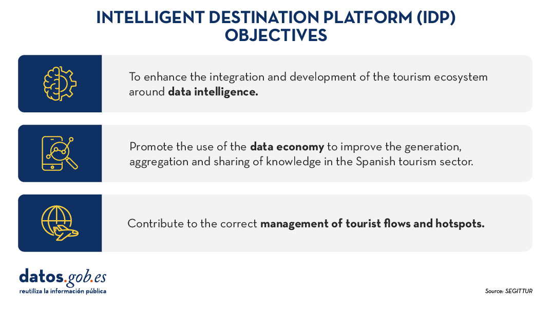
Figure 1. Objectives of the Intelligent Destination Platform (IDP).
New use cases and methodologies to implement them
To further harmonise data management, up to 25 use cases have been defined that enable different industry verticals to work in a coordinated manner. These verticals include areas such as wine tourism, thermal tourism, beach management, data provider hotels, impact indicators, cruises, sports tourism, etc.
To implement these use cases, a 5-step methodology is followed that seeks to align industry practices with a more structured approach to data:
- Identify the public problems to be solved.
- Identify what data are needed to be available to be able to solve them.
- Modelling these data to define a common nomenclature, definition and relationships.
- Define what technology needs to be deployed to be able to capture or generate such data.
- Analyse what intervention capacities, both public and private, are needed to solve the problem.
Boosting interoperability through a common ontology and data space
As a result of this definition of the 25 use cases, a ontology of tourism has been created, which they hope will serve as a global reference. The ontology is intended to have a significant impact on the tourism sector, offering a series of benefits:
- Interoperability: The ontology is essential to establish a homogeneous data structure and enable global interoperability, facilitating information integration and data exchange between platforms and countries. By providing a common language, definitions and a unified conceptual structure, data can be comparable and usable anywhere in the world. Tourism destinations and the business community can communicate more effectively and agilely, fostering closer collaboration.
- Digital transformation: By fostering the development of advanced technologies, such as artificial intelligence, tourism companies, the innovation ecosystem or academia can analyse large volumes of data more efficiently. This is mainly due to the quality of the information available and the systems' better understanding of the context in which they operate.
- Tourism competitiveness: Aligned with the previous question, the implementation of this ontology contributes to eliminating inequalities in the use and application of technology within the sector. By facilitating access to advanced digital tools, both public institutions and private companies can make more informed and strategic decisions. This not only raises the quality of the services offered, but also boosts the productivity and competitiveness of the Spanish tourism sector in an increasingly demanding global market.
- Tourist experience: Thanks to ontology, it is possible to offer recommendations tailored to the individual preferences of each traveller. This is achieved through more accurate profiling based on demographic and behavioural characteristics as well as specific motivations related to different types of tourism. By personalising offers and services, customer satisfaction before, during and after the trip is improved, and greater loyalty to tourist destinations is fostered.
- Governance: The ontology model is designed to evolve and adapt as new use cases emerge in response to changing market demands. SEGITTUR is actively working to establish a governance model that promotes effective collaboration between public and private institutions, as well as with the technology sector.
In addition, to solve complex problems that require the sharing of data from different sources, the Open Innovation Platform (PIA) has been created, a data space that facilitates collaboration between the different actors in the tourism ecosystem, both public and private. This platform enables secure and efficient data sharing, empowering data-driven decision making. The PIA promotes a collaborative environment where open and private data is shared to create joint solutions to address specific industry challenges, such as sustainability, personalisation of the tourism experience or environmental impact management.
Building consensus
SEGITTUR is also carrying out various initiatives to achieve the necessary consensus in the collection, management and analysis of tourism-related data, through collaboration between public and private actors. To this end, the Ente Promotor de la Plataforma Inteligente de Destinoswas created in 2021, which plays a fundamental role in bringing together different actors to coordinate efforts and agree on broad lines and guidelines in the field of tourism data.
In summary, Spain is making progress in the collection, management and analysis of tourism data through coordination between public and private actors, using advanced methodologies and tools such as the creation of ontologies, use cases and collaborative platforms such as PIA that ensure efficient and consensual management of the sector.
All this is not only modernising the Spanish tourism sector, but also laying the foundations for a smarter, more intelligent, connected and efficient future. With its focus on interoperability, digital transformation and personalisation of experiences, Spain is positioned as a leader in tourism innovation, ready to face the technological challenges of tomorrow.
Blog
Open data can transform how we interact with our cities, offering opportunities to improve quality of life. When made publicly available, they enable the development of innovative applications and tools that address urban challenges, from accessibility to road safety and participation.
Real-time information can have positive impacts on citizens. For example, applications that use open data can suggest the most efficient routes, considering factors such as traffic and ongoing construction; information on the accessibility of public spaces can improve mobility for people with disabilities; data on cycling or pedestrian routes encourages greener and healthier modes of transport; and access to urban data can empower citizens to participate in decision-making about their city. In other words, citizen use of open data not only improves the efficiency of the city and its services, but also promotes a more inclusive, sustainable and participatory city.
To illustrate these ideas, this article discusses maps for "navigating" cities, made with open data. In other words, initiatives are shown that improve the relationship between citizens and their urban environment from different aspects such as accessibility, school safety and citizen participation. The first project is Mapcesible, which allows users to map and assess the accessibility of different locations in Spain. The second, Eskola BideApp, a mobile application designed to support safe school routes. And finally, maps that promote transparency and citizen participation in urban management. The first identifies noise pollution, the second locates available services in various areas within 15 minutes and the third displays banks in the city. These maps use a variety of public data sources to provide a detailed overview of different aspects of urban life.
The first initiative is a project of a large foundation, the second a collaborative and local proposal, and the third a personal project. Although they are based on very different approaches, all three have in common the use of public and open data and the vocation to help people understand and experience the city. The variety of origins of these projects indicates that the use of public and open data is not limited to large organisations.
Below is a summary of each project, followed by a comparison and reflection on the use of public and open data in urban environments.
Mapcesible, map for people with reduced mobility
Mapcessible was launched in 2019 to assess the accessibility of various spaces such as shops, public toilets, car parks, accommodation, restaurants, cultural spaces and natural environments.

Figure 1. Mapcesible. Source: https://mapcesible.fundaciontelefonica.com/intro
This project is supported by organizations such as the NGO Spanish Confederation of People with Physical and Organic Disabilities (COCEMFE) and the company ILUNION. It currently has more than 40,000 evaluated accessible spaces and thousands of users.

Figure 2. Mapcesible. Source: https://mapcesible.fundaciontelefonica.com/filters
Mapcesible uses open data as part of its operation. Specifically, the application incorporates fourteen datasets from official bodies, including the Ministry of Agriculture and Environment, city councils of different cities (including Madrid and Barcelona) and regional governments. This open data is combined with information provided by the users of the application, who can map and evaluate the accessibility of the places they visit. This combination of official data and citizen collaboration allows Mapcesible to provide up-to-date and detailed information on the accessibility of various spaces throughout Spain, thus benefiting people with reduced mobility.
Eskola BideAPP, application to define safe school routes.
Eskola BideAPP is an application developed by Montera34 - a team dedicated to data visualisation and the development of collaborative projects - in alliance with the Solasgune Association to support school pathways. Eskola BideAPP has served to ensure that boys and girls can access their schools safely and efficiently. The project mainly uses public data from the OpenStreetMap, e.g. geographical and cartographic data on streets, pavements, crossings, as well as data collected during the process of creating safe routes for children to walk to school in order to promote their autonomy and sustainable mobility.
The application offers an interactive dashboard to visualise the collected data, the generation of paper maps for sessions with students, and the creation of reports for municipal technicians. It uses technologies such as QGIS (a free and open source geographic information system) and a development environment for the R programming language, dedicated to statistical computing and graphics.
The project is divided into three main stages:
- Data collection through questionnaires in classrooms.
- Analysis and discussion of results with the children to co-design personalised routes.
- Testing of the designed routes.
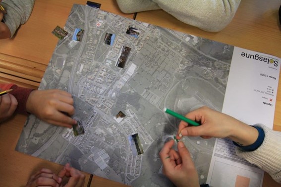
Figure 3. Eskola BideaAPP. Photo by Julián Maguna (Solasgune). Source: https://montera34.com/project/eskola-bideapp/
Pablo Rey, one of the promoters of Montera34 together with Alfonso Sánchez, reports for this article that Eskola BideAPP, since 2019, has been used in eight municipalities, including Derio, Erandio, Galdakao, Gatika, Plentzia, Leioa, Sopela and Bilbao. However, it is currently only operational in the latter two. "The idea is to implement it in Portugalete at the beginning of 2025," he adds.
It''s worth noting the maps from Montera34 that illustrated the effect of Airbnb in San Sebastián and other cities, as well as the data analyses and maps published during the COVID-19 pandemic, which also visualized public data.In addition, Montera34 has used public data to analyse abstention, school segregation, minor contracts or make open data available to the public. For this last project, Montera34 has started with the ordinances of the Bilbao City Council and the minutes of its plenary sessions, so that they are not only available in a PDF document but also in the form of open and accessible data.
Mapas de Madrid sobre contaminación acústica, servicios y ubicación de bancos
Abel Vázquez Montoro has made several maps with open data that are very interesting, for example, the one made with data from the Strategic Noise Map (MER) offered by the Madrid City Council and land registry data. The map shows the noise affecting each building, facade and floor in Madrid.

Figure 4. Noise maps in Madrid. Source: https://madb.netlify.app/.
This map is organised as a dashboard with three sections: general data of the area visible on the map, dynamic 2D and 3D map with configurable options and detailed information on specific buildings. It is an open, free, non-commercial platform that uses free and open source software such as GitLab - a web-based Git repository management platform - and QGIS. The map allows the assessment of compliance with noise regulations and the impact on quality of life, as it also calculates the health risk associated with noise levels, using the attributable risk ratio (AR%).
15-minCity is another interactive map that visualises the concept of the "15-minute city" applied to different urban areas, i.e. it calculates how accessible different services are within a 15-minute walking or cycling radius from any point in the selected city.

Figure 5. 15-minCity. Source: https://whatif.sonycsl.it/15mincity/15min.php?idcity=9166
Finally, "Where to sit in Madrid" is another interactive map that shows the location of benches and other places to sit in public spaces in Madrid, highlighting the differences between rich (generally with more public seating) and poor (with less) neighbourhoods. This map uses the map-making tool, Felt, to visualise and share geospatial information in an accessible way. The map presents different types of seating, including traditional benches, individual seats, bleachers and other types of seating structures.

Figure 6. Where to sit in Madrid. Source: https://felt.com/map/Donde-sentarse-en-Madrid-TJx8NGCpRICRuiAR3R1WKC?loc=40.39689,-3.66392,13.97z
Its maps visualise public data on demographic information (e.g. population data by age, gender and nationality), urban information on land use, buildings and public spaces, socio-economic data (e.g. income, employment and other economic indicators for different districts and neighbourhoods), environmental data, including air quality, green spaces and other related aspects, and mobility data.
What do they have in common?
| Name | Promoter | Type of data used | Profit motive | Users | Characteristics |
|---|---|---|---|---|---|
| Mapcesible | Telefónica Foundation | Combines user-generated and public data (14 open data sets from government agencies) | Non-profit | More than 5.000 | Collaborative app, available on iOS and Android, more than 40,000 mapped accessible points. |
| Eskola BideAPP | Montera34 and Solasgune Association | Combines user-generated and public data (classroom questionnaires) and some public data. | Non-profit. | 4.185 | Focus on safe school routes, uses QGIS and R for data processing |
| Mapa Estratégico de Ruido (MER) | Madrid City Council | 2D and 3D geographic and visible area data | Non-profit | No data | It allows the assessment of compliance with noise regulations and the impact on quality of life, as it also calculates the associated health risk. |
| 15 min-City | Sony GSL | Geographic data and services | Non-profit | No data | Interactive map visualising the concept of the "15-minute city" applied to different urban areas. |
| MAdB "Dónde sentarse en Madrid" | Private | Public data (demographic, electoral, urban, socio-economic, etc.) | Non-profit | No data | Interactive maps of Madrid |
Figure 7. Comparative table of solutions
These projects share the approach of using open data to improve access to urban services, although they differ in their specific objectives and in the way information is collected and presented. Mapcesible, Eskola BideApp, MAdB and "Where to sit in Madrid" are of great value.
On the one hand, Mapcesible offers unified and updated information that allows people with disabilities to move around the city and access services. Eskola BideApp involves the community in the design and testing of safe routes for walking to school; this not only improves road safety, but also empowers young people to be active agents in urban planning. In the meantime, 15-min city, MER and the maps developed by Vázquez Montoro visualise complex data about Madrid so that citizens can better understand how their city works and how decisions that affect them are made.
Overall, the value of these projects lies in their ability to create a data culture, teaching how to value, interpret and use information to improve communities.
Content created by Miren Gutiérrez, PhD and researcher at the University of Deusto, expert in data activism, data justice, data literacy, and gender disinformation. The contents and viewpoints reflected in this publication are the sole responsibility of the author.
Noticia
The Ministry for Digital Transformation and Public Administration has launched a grant for the development of Data Spaces for Intelligent Urban Infrastructures (EDINT). This project envisages the creation of a multi-sectoral data space that will bring together all the information collected by local authorities. The project will be carried out through the Spanish Federation of Municipalities and Provinces (FEMP) and will receive a subsidy of 13 million euros, as stated in the Official State Gazette published on Wednesday 16 October.
A single point of access to smart urban infrastructure data
Thanks to this action, it will be possible to finance, develop and manage a multisectoral data space that will bring together all the information collected by the different Spanish municipalities in an aggregated and centralized manner. It should be recalled that data spaces enable the voluntary sharing of information in an environment of sovereignty, trust and security, established through integrated governance, organisational, regulatory and technical mechanisms.
EDINT will act as a single neutral point of access to smart city information, enabling companies, researchers and administrations to access information without the need to visit the data infrastructure of each municipality, increasing agility and reducing costs. In addition, it will allow connection with other sectoral data spaces.
The sharing of this data will help to accelerate technological innovation processes in smart city products and services. Businesses and organisations will also be able to use the data for the improvement of processes and efficiency of their activities.
The Spanish Federation of Municipalities and Provinces (FEMP) will implement the project.
The EDINT project will be articulated through the Spanish Federation of Municipalities and Provinces.The FEMP reaches more than 95% of the Spanish population, which gives it a deep and close knowledge of the needs and challenges of data management in Spanish municipalities and provinces.
Among the actions to be carried out are:
- Development and implementation of the data infrastructure and platform, which will store data from existing Smart City systems.
- Incorporation of local entities and companies interested in accessing the data space.
- Development of three use cases on the data space, focusing on the following areas: "smart mobility", "managed cities and territories" and "mapping the economic and social activity of cities and territories".
- Definition of the governance schemes that will regulate the operation of the project, guaranteeing the interoperability of the data, as well as the management of the complex network of stakeholders (companies, academic institutions and governmental organisations).
- Setting up Centres of Excellence and Data Offices, with physical workspaces. These centres will be responsible for the collection of lessons learned and the development of new use cases.
It is a ongoing and sustainable long-term project that will be open to the participation of new actors, be they data providers or data consumers, at any time.
A project aligned with Europe
This assistance is part of the Recovery, Transformation and Resilience Plan, funded by the European Union-Next Generation EU. The creation of data spaces is envisaged in the European Data Strategy, as a mechanism to establish a common data market to ensure the European Union's leadership in the global data economy. In particular, it aims to achieve the free flow of information for the benefit of businesses, researchers and public administrations.
Moreover, data spaces are a key area of the Digital Spain 2026 Agenda, which is driving, among other issues, the acceleration of the digitalisation processes of the productive fabric. To this end, sectoral and data-intensive digitalisation projects are being developed, especially in strategic economic sectors for the country, such as agri-food, mobility, health, tourism, industry, commerce and energy.
The launch of the EDINT project joins other previously launched initiatives such as funding and development grants for use cases and data space demonstrators, which encourage the promotion of public-private sectoral innovation ecosystems.
Sharing data under conditions of sovereignty, control and security not only allows local governments to improve efficiency and decision-making, but also drives the creation of creative solutions to various urban challenges, such as optimising traffic or improving public services. In this sense, actions such as the Data Spaces for Smart Urban Infrastructures represent a step forward in achieving smarter, more sustainable and efficient cities for all citizens.
Blog
Autonomous vehicles, smart waste management services, trainers that monitor how much we exercise... We live in an increasingly digital and connected environment, with greater similarities to the future we dreamed of as children. It is the so-called Internet of Things (IoT), a network of physical objects that use sensors and APIs to connect with each other and exchange data over the Internet. Its rise is unstoppable and by 2025 it is expected that there will be more than 30 billion IoT connections in the world, which is an average of almost 4 IoT devices per person.
This boom means that the amount of data to be processed and managed is increasing. Traditionally, these connected objects collect information and send it to large data centres for processing. But sending the data to the data centre for processing takes time that we sometimes don't have, and the problem comes in certain use cases where fast responses are needed and every millisecond is crucial, such as in autonomous driving. This is where the edge computing paradigm comes in, as a way to improve agility and efficiency.
What is edge computing?
Edge computing is a new approach to running certain services as close as possible to the source of the data. In other words, computational processes are performed on the connected devices themselves or on local peripheral servers (edge nodes). This brings a number of advantages:
- Lower latency time and higher speed. Latency is the time it takes for a data packet to be transferred within the network. By avoiding the step of sending all the information for processing to the cloud, the response time is reduced, providing immediacy.
- Lower bandwidth requirement, as it is not necessary to send all raw data to servers. Edge computing reduces global traffic loads, avoiding system saturation.
- Reduced security risks. It is true that edge computing expands the potential attack surface, but it reduces the impact on the organisation as a whole. When you centralise all data, analytics and processing, a single denial-of-service attack can disrupt all operations. By distributing the loads across the various nodes, the risk is also distributed. One process may fail, but the rest could continue to operate.
- Facilitates scalability. Given the exponential growth of data and analytics capabilities, it is difficult to foresee the IT infrastructure needs to cope with the future (e.g. servers with the capacity to analyse all incoming information). By incorporating edge computing services, organisations can quickly and cost-effectively extend the reach of their network by adding a new edge node.
- Reduced costs. Edge computing devices require more software capabilities for optimal performance than those that simply capture data and send it for remote analysis. However, they also allow data to be sorted from a management perspective. In other words, devices can be deployed with customised capabilities for various analytics, without the need to over-invest.
Advances in edge computing go hand in hand with 5G, which enables more devices to connect to each other and exchange data at higher speeds.
Edge computing will also continue to be complemented by cloud environments: edge computing capabilities will be more appropriate where speed and low latency in data transfer are needed, while the cloud will continue to be essential for handling large volumes of data that require greater computing power.
The impact of edge computing on smart cities
Given the above advantages, it seems obvious that edge computing represents a breakthrough for data management in various sectors, from healthcare and telemedicine to Industry 4.0. For example, Navantia, the Spanish public shipbuilding company, is implementing this technology, with the support of Red.es. Combining 5G, edge computing and the use of augmented reality glasses, it is innovating in construction processes and remote technical assistance.
But if there is one area where edge computing is particularly important, it is in smart cities. In essence, smart cities rely on IoT devices to provide connectivity and situational data analysis. Devices such as security cameras and various sensors - which transmit data related to transportation, lighting or smart buildings - operate within a city-wide network to provide a better experience for citizens. Edge computing and 5G facilitate real-time decisions, which can be made automatically by the devices themselves rather than sending data to another central computer for processing, making it easier to manage the city. This can also have an impact on the publication of open data, which could be made more agile and accessible through dynamic services.
In the city of Barcelona, edge computing use cases are being tested in different applications, such as urban transport, public safety and health services, also with the support of Red.es. Among other issues, thanks to these technologies, they are measuring in real time the best routes for getting around or achieving faster action by the urban police in the event of atmospheric phenomena.
The future of edge computing
Edge computing is expected to gradually take hold. According to EU data - based on an IDC estimate - in 2018, 80% of data processing was carried out in centralised computing facilities and 20% in the smart connected objects themselves. In 2025, the situation will be the other way around, as the following graph shows.

The European Commission, among its activities, also seeks to boost the deployment of technologies linked to edge computing, due to the numerous opportunities it offers. In this respect, its cloud activities fall into two categories:
- Invest funds in cutting-edge projects related to cloud and edge computing.
- Develop policies and standards that protect users, make cloud services more secure, ensure fair competition and create the optimal framework conditions for a thriving European industry.
In the case of Spain, we face the challenge of building 1,000 edge nodes in nine years.
In short, we are facing a new technological paradigm that is necessary due to the enormous amount of data generated not only by smart cities, but also by practically all sectors that are increasingly seeking to be more connected. This generates a need for speed and immediate analysis capabilities that edge computing can help to boost.
Content prepared by the datos.gob.es team.
Blog
Mobility is a key economic driver. Increasing the efficiency and quality of a country's mobility system contributes both to the strength of its economy and to improving the quality of life of its citizens. This is particularly important in the mobility systems of cities and their metropolitan areas, where most of the population and, thus, most of the economic activity is concentrated.
Aware of this - and because we citizens demand it - local authorities have for decades allocated a significant part of their annual resources to expanding, improving and making their transport and mobility networks more efficient.
In the last decade, open data has been one of the most important vectors of innovation that have been introduced in the mobility strategies developed by cities, giving rise to initiatives that would have been difficult to imagine in previous periods. Despite all the complexities involved, opening both static and real-time mobility datasets for reuse is actually cheap and simple compared to the cost of building a new transport infrastructure or the cost of acquiring and maintaining the operational support systems (OSS) associated with mobility services. In addition, the existence of an increasing deployment of sensor networks, accessible through control systems deployed in the context of "smart city" strategies, makes the task a little easier.
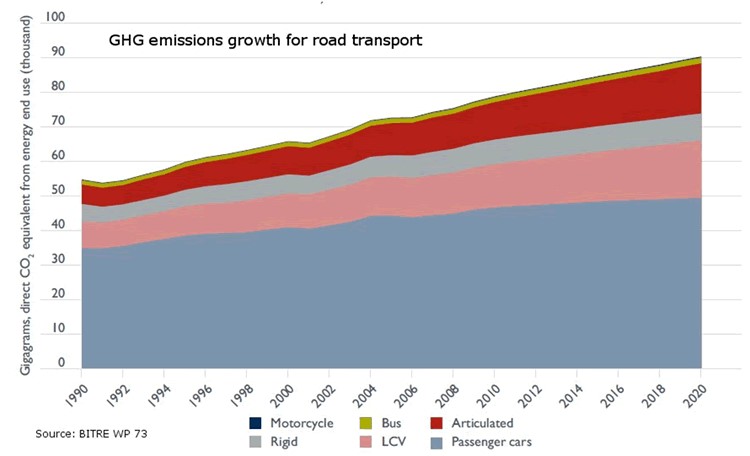
We should not forget, moreover, that public transport is key to tackling climate change as it is one of the fastest growing sources of greenhouse gas emissions, and public transport offers the best mobility solution to move people quickly and efficiently in cities around the world. As shown in the figure, simply shifting passengers using their private vehicles to public transport has a major impact on reducing greenhouse gas emissions. The Bus Industry Confederation estimates that shifting passengers from cars to public transport can lead to a 65% reduction in emissions during peak hours. This reduction could be as high as 95% in emissions during off-peak hours for those commuters who switch from private cars to public transport.
For all these reasons, there are already numerous examples where freeing up transport and mobility data to put it in the hands of travellers is proving to be a policy with important benefits for many cities: it allows better use of resources and contributes to more efficient mobility in urban space.
Let's look at some examples that may not be as well-known as the ones that usually reach the media, but which demonstrate how the release of data allows for innovations that benefit both users and, in some cases, the authorities themselves.
Redesigning New York City bus routes
All cities are constantly thinking of ways to improve their bus routes in order to provide the best possible service to citizens. In New York City, however, the open data policy, as an unplanned consequence, provided an important aid to the authorities, based on the analysis of data from the bus network users themselves.
The rider-driven Bus Turnaround Coalition campaign, supported by TransitCenter, a foundation working to improve public transport in US cities, and the Riders Alliance, is using open data to raise awareness about the state of New York City's bus network, proposing solutions for improvement to the Metropolitan Transportation Authority (MTA).
To formulate their recommendations, the organisations analysed bus arrival times using the MTA's own location maps, incorporated real-time data through the GTFS specification, reviewed ridership data, and mapped (and optimised) bus routes.
Among the most innovative proposals is the shift in approach to route design criteria. Instead of trying to cater to all types of travellers, the Bus Turnaround Coalition, after analysing how people actually move around the city and what type of transport they would need to achieve their goals efficiently, proposed the following recommendations:
- Add lines to take passengers from the outskirts of the city directly to the underground lines, facilitating a quick trip.
- Improve lines to offer short, fast routes within a neighbourhood for people who want to run a quick errand or visit a close friend.
- Split routes that are too long to minimise the risk of delays.
- Readjust the distance between stops, which are often too close together, complementing gaps in metro coverage.
Open data has turned frequent rider protests and complaints about poor network performance into a set of reasoned, data-driven inputs, which have been captured in a series of MTA commitments to improve New York's bus network, such as redesigning the network by 2021, increasing journey speeds by 25%, and proactively managing bus maintenance.
Bicycle usage data in San Francisco
Like many other cities, San Francisco, through its Municipal Transportation Agency (SFMTA), records travel data from users of its public bike-sharing system and makes it available as open data. In this case, the transport authority itself publishes regular reports, both on the overall use of the system and on the conclusions it draws for the improvement of the city's own mobility.
By documenting and analysing the volumes and trends of bicycle use in San Francisco, they are able to support the goals of the SFMTA's Strategic Plan, which aims to prioritise other forms of travel in the city than the private car.
For example, ongoing analysis of bicycle passenger volumes at key intersections in the city and citizen input has reduced traffic congestion and accidents by re-prioritising vehicle traffic priorities according to actual roadway usage at any given time of day.
Efficient parking in Sacramento
Many cities try to address traffic congestion problems from different perspectives including efficient parking management. Therefore, one of the datasets frequently published by cities with open data initiatives is public parking occupancy.
In the city of Sacramento, California, the open data initiative publishes datasets from the citywide sensor network that monitors parking availability at parking meters and not only in the city's public car parks. In this way they have managed to reduce emissions as vehicles spend less time looking for parking, while significantly improving traffic flow and the satisfaction of citizens using the Sacpark app.
In 2020, due to the pandemic, passenger transport around the world was drastically reduced due to the mobility restriction policies that governments around the world had to deploy to curb the spread of the virus, as seen in the image below.
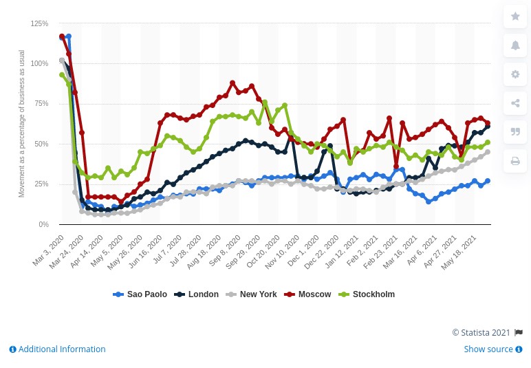
In June 2021 cities are still far from recovering the levels of mobility they had in March 2020, but we continue to make progress in making data the basis on which to build useful information, and essential in the new innovations coming through artificial intelligence.
So, as the pandemic recedes, and many initiatives resume, we continue to see how open data is at the heart of smart, connected and environmentally friendly mobility strategies.
Content prepared by Jose Luis Marín, Senior Consultant in Data, Strategy, Innovation & Digitalization.
The contents and views reflected in this publication are the sole responsibility of the author.
Documentación
The saying "a picture is worth a thousand words" is a clear example of popular wisdom based on science. 90% of the information we process is visual, thanks to a million nerve fibers that link the eye to the brain and more than 20,000 million neurons that perform the processing of the impulses received at high speed. That is why we are able to remember 80% of the images we see, while in the case of text and sound the percentages are reduced to 20% and 10%, respectively.
These data explain the importance of data visualization in any sector of activity. It is not the same to tell how an indicator evolves, as to see it through visual elements, such as graphs or maps. Data visualization helps us understand complex concepts and is an accessible way to detect and understand trends and patterns in the data.
Data Visualization and Smart Cities
In the case of Smart Cities, where so much information is generated and captured, data visualization is fundamental. Throughout the length and breadth of a smart city, there are a large number of sensors and smart devices, with different detection capabilities, which generate a large amount of raw data. To give an example, only the city of Barcelona has more than 18,000 sensors spread throughout the city that capture millions of data. This data allows from real time monitoring of the environment to informed decision making or accountability. Visualizing this data through visual dashboards speeds up all these processes.
To help Smart Cities in this task, from the Open Cities project, led by Red.es and four city councils (A Coruña, Madrid, Santiago de Compostela and Zaragoza), a series of visualization tools have been selected and an extension has been developed for CKAN similar to the functionality "Open With Apps", initially designed for the Data.gov portal, which facilitates the integration with this type of tools.
The integration method inspired by "Open with Apps"
The idea behind "Open With Apps" is to allow integration with some third party services, for some formats published in the open data portals, such as CSV or XLS, without the need to download and upload data manually, through the APIs or URIs of the external service.
But not all display systems allow this functionality. Therefore, since the Open Cities project they have analyzed several platforms and online tools for creating visualizations and data analysis, and have selected 3 that meet the necessary characteristics for the described operation:
- The integration is done through links to websites without the need to download any software.
- In the invocation it is only necessary to pass as a parameter the download URL of the data file.
The result of this analysis has given rise to the report "Analysis and definition of specifications for integration with external visualization systems", where 3 tools that comply with these functionalities are highlighted.
3 simple data visualization and analysis tools
According to the aforementioned report, the 3 platforms that meet the necessary characteristics to achieve such operation are:
- Plotly: facilitates the creation of interactive data visualizations and control panels to share online with the audience. More advanced users can process data with any custom function, as well as create simulations with Python scripts. Supported formats are CSV, TSV, XLS and XLSX.
- Carto: formerly known as CartoDB, it generates interactive maps from geospatial data. The maps are automatically created and the user can filter and refine the data for more information. It accepts files in CSV, XLS, XLSX, KML (Google Earth), KMZ, GeoJSON and SHP formats.
- Geojson.io: allows to visualize and edit geographic data in GeoJSON format, as well as to export to a large number of formats.
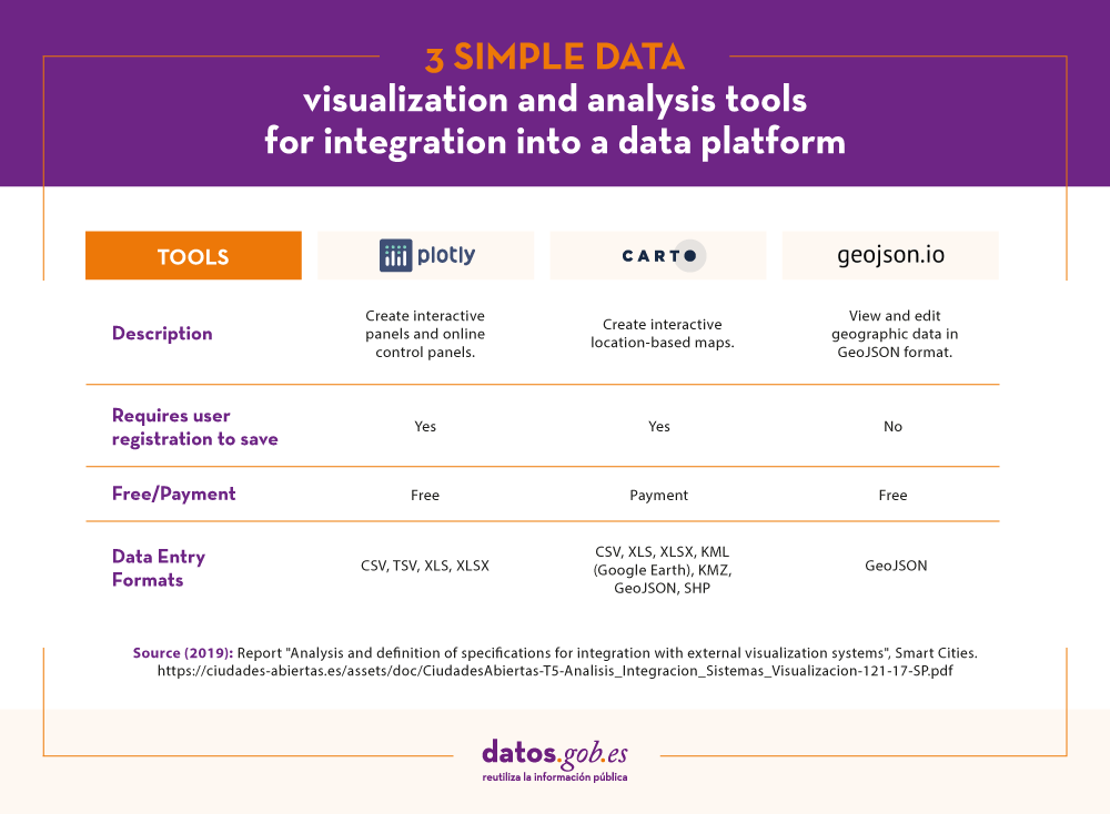
For each of these tools the report includes a description of its requirements and limitations, its mode of use, a generic call and specific examples of calls along with the result obtained.
The "Open with" extension
As mentioned above, within the project a CKAN extension called "Open with" has also been developed. This extension allows to visualize the data files using the external visualization systems described above. It can be accessed through the project's GitHub account.
The report explains how to carry out its installation in a simple way, although if any doubt arises about its operation, users can contact Open Cities through the e-mail contacto@ciudadesabiertas.es.
Those interested in other CKAN extensions related to data visualization have at their disposal the report Analysis of the Visualization Extensions for CKAN, carried out within the framework of the same initiative. In the Gighub account, it is expected that examples of visualizations made will be published.
In short, data visualization is a fundamental leg of Smart Cities, and thanks to the work of the Open Cities team it will now be easier for any initiative to integrate simple data visualization solutions into their information management platforms.
Blog
People, governments, economy, infrastructure, environment ... all these elements come together in our cities and they have to make the most of the constant flow of data on their streets to be more efficient. Analysis of the efficiency of services, monitoring of investment, improvement of public transport, participation and collaboration with citizens, reduction of waste or prevention of natural disasters are just some of the multiple examples of innovation in cities driven by data that how local governments are getting better services and improving the quality of life of their citizens thanks to the openness and better exploitation of their data.
From finding a parking space to discover new leisure places or simply move around the city. The applications that facilitate us day by day are already part of the usual urban landscape. At the same time, the data is also transforming the cities little by little and offers us an alternative vision of them through the definition of new virtual neighborhoods based on the footprint we are leaving with our actions and our data.
Hyperconnected cities, driven by data, managed by artificial intelligence and inhabited by a greater number of robots than humans will no longer be exclusive to science fiction movies and series, but real projects in the middle of the desert with already defined plans that have been launched in search of diversification and with the aim of transforming and renewing economies that are too dependent on the old oil ironically thanks to the supposed new oil of the data. Returning for a moment to the present, we also find examples of how this transformation through data is real and is happening in such tangible cases as the prevention of crimes and the reduction of violence in the favelas of Rio de Janeiro.
But not all expectations are so optimistic, since the transformative vision that some technology companies have for our neighborhoods also generates serious doubts, not only about how our most personal data will be managed and who will actually be the othe that have access and control over them, but also on the supposed transforming power of the data itself.
Right now the only thing that seems to be totally clear is that the role of data in the transformation of cities and citizens of the immediate future will be essential and we must find our own way halfway between the most optimistic and the most pessimistic visions to define what we understand as the new paradigm of Smart Cities, but always with a focus on the human element and not only on purely technological aspects and with participation and co-creation as key elements.
Evento
The fifth edition of the International Open Data Conference (IODC) is already underway. This year, it will be held in Buenos Aires, Argentina, on September 27-28. This biannual event brings together the international open data community with the objective of sharing, planning and collaborating on different current and future initiatives.
IODC seeks to identify and explore new trends that are emerging around open data, promoting innovative solutions capable of generating economic and social impact in different sectors. The event is also an opportunity to consolidate international relations and promote common resources development.
The Future is Open, central topic of this edition
2018 IODC sessions will focus on challenges and opportunities facing the open data community, under the title The Future is Open.
IODC organizers are committed to creating an inclusive and innovative event, including issues of concern to the international community. Therefore, the agenda will be created through a global call for proposals, that search for inclusion of all voices achieve the greatest possible level of gender balance and regional diversity.
The call for porposals will be open between February 14 and April 1, 2018. A committee comprised of open data experts, including representatives of public and private organizations and academic institutions, will evaluate all submissions received.
Submissions should target one of three conference tracks:
- The Big Picture (45 minutes-1 hour): Panels and debates focused on the exploration of emerging trends and challenges. They can include topics related to privacy, gender, algorithms, Big Data, artificial intelligence or other emerging technologies.
- Action Track (45 minutes-1 hour): Sessions and workshops that allow for the exchange of information. This category includes interactive discussions, brainstorming sessions, cases studies or roundtables. Sessions should contribute to enrich international collaboration areas identified in previous conferences.
- Impact Track (10-15 minutes): Short and dynamic sessions that show concrete examples of open data use within the different sectors, such as agriculture, education, health or transport, among others.
It is important to mention that those proposals that identify specific challenges and promote the search for solutions through dialogue will have preference. Proposals focused on gender issues that promote parity in participation, practices and processes will also highlight.
This year's conference will also highlight The State of Open Data initiative. This project focuses on the review of open data movement development during the last 10 years, with the aim of learning from errors and generating recommendations and good practices.
Madrid, headquarter of the previous edition
IODC previous edition took place in Madrid, on October 6 - 7, 2018. More than 1,600 attendees from a hundred countries visited the Spanish capital to participate in some of the 87 sessions given by more than 300 experts.
You can read event conclusions in the following link: IOCD Madrid 2016 conclusions.
Documentación
As a result of transparency and citizen participation demand, an increasing number of towns are focus on initiatives that facilitate citizen access to institutions and administrations´ information. However, defining, implementing and documenting an open data policy could be a challenging issue. Some of the most frequently asked questions by agents involved in these initiatives are:
-
Which data are more strategic and which fundamental aspect should be consider at publishing?
-
How could I facilitate datasets integration from different sources?
-
What is the regulatory framework?
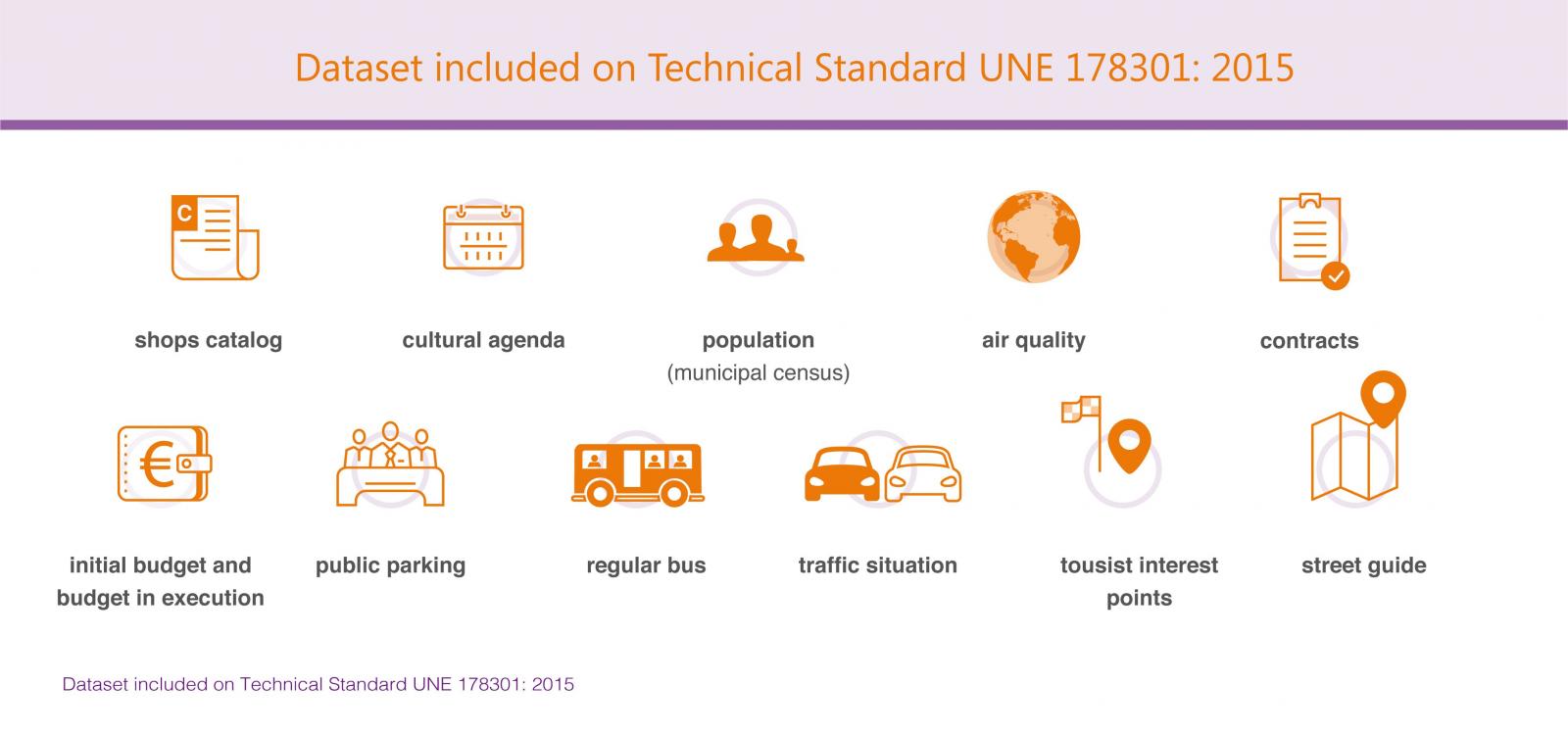
In this context, AENOR elaborated the Technical Standard UNE 178301: 2015. It provides a series of recommendations to standardize open data publication and improve data management. This Technical Standard includes a list of 11 datasets considered a priority by AENOR: shops catalog, cultural agenda, population (municipal census), air quality, contracts, initial budget and budget in execution, public parking, regular bus, traffic situation, tourist interest points and street guide.
In addition, Technical Standard UNE 178301: 2015 includes recommended vocabulary to optimize data publication, framed within Linked Data paradigm (a set of best practices, articulated through W3C standard technologies). The objective is to facilitate the development of a data website where different elements can be linked, simplifying navigation and data location, within a common international framework.
The report "Open data representation vocabulary in Digital Cities" provides an analysis of this Technical Standard. It include the description of each dataset, potential use cases and legislative framework- when applicable–, and common publication formats. In addition, the report includes an assessment of AENOR´s semantic proposal adequacy and development degree.