Publication date
27/07/2021
Update date
20/06/2024

Description
Mobility is a key economic driver. Increasing the efficiency and quality of a country's mobility system contributes both to the strength of its economy and to improving the quality of life of its citizens. This is particularly important in the mobility systems of cities and their metropolitan areas, where most of the population and, thus, most of the economic activity is concentrated.
Aware of this - and because we citizens demand it - local authorities have for decades allocated a significant part of their annual resources to expanding, improving and making their transport and mobility networks more efficient.
In the last decade, open data has been one of the most important vectors of innovation that have been introduced in the mobility strategies developed by cities, giving rise to initiatives that would have been difficult to imagine in previous periods. Despite all the complexities involved, opening both static and real-time mobility datasets for reuse is actually cheap and simple compared to the cost of building a new transport infrastructure or the cost of acquiring and maintaining the operational support systems (OSS) associated with mobility services. In addition, the existence of an increasing deployment of sensor networks, accessible through control systems deployed in the context of "smart city" strategies, makes the task a little easier.
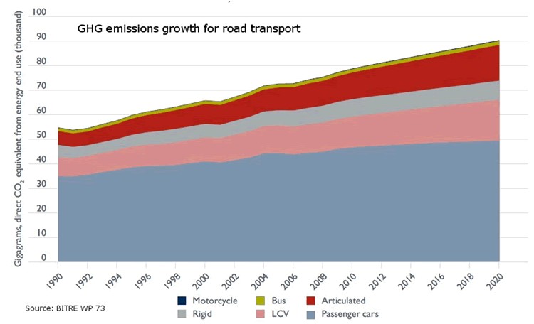
We should not forget, moreover, that public transport is key to tackling climate change as it is one of the fastest growing sources of greenhouse gas emissions, and public transport offers the best mobility solution to move people quickly and efficiently in cities around the world. As shown in the figure, simply shifting passengers using their private vehicles to public transport has a major impact on reducing greenhouse gas emissions. The Bus Industry Confederation estimates that shifting passengers from cars to public transport can lead to a 65% reduction in emissions during peak hours. This reduction could be as high as 95% in emissions during off-peak hours for those commuters who switch from private cars to public transport.
For all these reasons, there are already numerous examples where freeing up transport and mobility data to put it in the hands of travellers is proving to be a policy with important benefits for many cities: it allows better use of resources and contributes to more efficient mobility in urban space.
Let's look at some examples that may not be as well-known as the ones that usually reach the media, but which demonstrate how the release of data allows for innovations that benefit both users and, in some cases, the authorities themselves.
Redesigning New York City bus routes
All cities are constantly thinking of ways to improve their bus routes in order to provide the best possible service to citizens. In New York City, however, the open data policy, as an unplanned consequence, provided an important aid to the authorities, based on the analysis of data from the bus network users themselves.
The rider-driven Bus Turnaround Coalition campaign, supported by TransitCenter, a foundation working to improve public transport in US cities, and the Riders Alliance, is using open data to raise awareness about the state of New York City's bus network, proposing solutions for improvement to the Metropolitan Transportation Authority (MTA).
To formulate their recommendations, the organisations analysed bus arrival times using the MTA's own location maps, incorporated real-time data through the GTFS specification, reviewed ridership data, and mapped (and optimised) bus routes.
Among the most innovative proposals is the shift in approach to route design criteria. Instead of trying to cater to all types of travellers, the Bus Turnaround Coalition, after analysing how people actually move around the city and what type of transport they would need to achieve their goals efficiently, proposed the following recommendations:
- Add lines to take passengers from the outskirts of the city directly to the underground lines, facilitating a quick trip.
- Improve lines to offer short, fast routes within a neighbourhood for people who want to run a quick errand or visit a close friend.
- Split routes that are too long to minimise the risk of delays.
- Readjust the distance between stops, which are often too close together, complementing gaps in metro coverage.
Open data has turned frequent rider protests and complaints about poor network performance into a set of reasoned, data-driven inputs, which have been captured in a series of MTA commitments to improve New York's bus network, such as redesigning the network by 2021, increasing journey speeds by 25%, and proactively managing bus maintenance.
Bicycle usage data in San Francisco
Like many other cities, San Francisco, through its Municipal Transportation Agency (SFMTA), records travel data from users of its public bike-sharing system and makes it available as open data. In this case, the transport authority itself publishes regular reports, both on the overall use of the system and on the conclusions it draws for the improvement of the city's own mobility.
By documenting and analysing the volumes and trends of bicycle use in San Francisco, they are able to support the goals of the SFMTA's Strategic Plan, which aims to prioritise other forms of travel in the city than the private car.
For example, ongoing analysis of bicycle passenger volumes at key intersections in the city and citizen input has reduced traffic congestion and accidents by re-prioritising vehicle traffic priorities according to actual roadway usage at any given time of day.
Efficient parking in Sacramento
Many cities try to address traffic congestion problems from different perspectives including efficient parking management. Therefore, one of the datasets frequently published by cities with open data initiatives is public parking occupancy.
In the city of Sacramento, California, the open data initiative publishes datasets from the citywide sensor network that monitors parking availability at parking meters and not only in the city's public car parks. In this way they have managed to reduce emissions as vehicles spend less time looking for parking, while significantly improving traffic flow and the satisfaction of citizens using the Sacpark app.
In 2020, due to the pandemic, passenger transport around the world was drastically reduced due to the mobility restriction policies that governments around the world had to deploy to curb the spread of the virus, as seen in the image below.
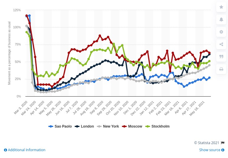
In June 2021 cities are still far from recovering the levels of mobility they had in March 2020, but we continue to make progress in making data the basis on which to build useful information, and essential in the new innovations coming through artificial intelligence.
So, as the pandemic recedes, and many initiatives resume, we continue to see how open data is at the heart of smart, connected and environmentally friendly mobility strategies.
Content prepared by Jose Luis Marín, Senior Consultant in Data, Strategy, Innovation & Digitalization.
The contents and views reflected in this publication are the sole responsibility of the author.
Comments