Evento
The XII Iberian Conference on Spatial Data Infrastructures (JIIDE, in Spanish acronyms) will be held virtually from 15 to 19 November 2021. In this online event, in which the Aporta Initiative will participate, technical sessions, workshops and round tables will be held to share and disseminate the harmonization, standardization and publication of geographic information through Spatial Data Infrastructures. Specifically, this edition will address issues related to reuse and digital ecosystems.
What are the JIIDE and who are they aimed at?
The Iberian Conference on Spatial Data Infrastructures is held once a year due to the collaboration between the Direção-Geral do Território de Portugal, the Govern d'Andorra and the Spanish National Center for Geographic Information. Its objective is to raise awareness of the state of development of interoperable spatial data services technologies through the exchange of experiences and knowledge.
This conference is aimed at professionals from the public administration, the private sector and academia who deal with geographic information. In other words, they are open to all those who use or intend to use Spatial Data Infrastructures (SDI) in the exercise of their activities.
What is the agenda?
The XII JIIDE will be held this year under the theme "Digital Ecosystems and Interoperability" and will be divided into four days (from November 15 to 19). Each of the 4 days will have different sessions throughout the day and all of them will end with a workshop in which the analyzed topics will be put into practice.
Here you can register to the workshops and sessions of the agenda of the XII Iberian Conference on Spatial Data Infrastructures that are of your interest. To see the complete schedule of sessions, click on this link.
Topics such as the publication and exchange of data, the tools used or the local implementation of open data catalogs, among others, will be addressed. The Aporta Initiative will participate in the latter.
The Aporta Initiative at the JIIDE
On Monday, November 15, the Aporta Initiative will participate in the first session "Catalog and open data". During this intervention, the "Publication of the resources of the Official INSPIRE Data and Services Catalog in datos.gob.es" will be discussed.
During the intervention, the collaboration between datos.gob.es and the National Center for Geographic Information (CNIG, in Spanish acronyms) for the automatic publication of resources, i.e., through a federation process, will be presented. To achieve this, the Aporta Initiative has implemented a script that harmonizes the INSPIRE data and services catalog with the metadata defined in the NTI-RISP (Technical Standard for Interoperability) of the open data catalog datos.gob.es.
The presentation will have 3 main axes:
- IDEE (Spatial Data Infrastructure of Spain) / INSPIRE - APORTA interaction: areas of cooperation. After a brief presentation and introduction about the Aporta Initiative to explain what it is and what are our main functions in the world of open data, we will analyze the areas of cooperation between our initiative and the IDEE, which are characterized by three aspects: regulation, dissemination and cooperation.
- Aporta - IDEE collaboration in publishing. One of the challenges in publishing the resources of the Official Catalog of INSPIRE Data and Services (CODSI, in Spanish) in datos.gob.es was the large volume of existing data. To solve it, we proposed the automatic import to our portal the 527 datasets and information services available through a mapping procedure divided into two processes: the parse reading or INSPIRE metadata analysis process and the process of serialization to NTI-RISP metadata.
- Next IDEE - INSPIRE actions. In this point we will share some of the next actions that we will carry out in this aspect, such as the joint work for the definition and requirements of high value dataset in the Directive 2019/1024 or the inclusion of the geospatial characteristics of the European vocabulary DCAT-AP in the revised version of the NTI.
These are just some of the main ideas that will be addressed during the XII Iberian Conference on Spatial Data Infrastructures. If you do not want to miss all the details, we invite you to register and participate in this interesting event.
Blog
Throughout history, geospatial data have allowed humankind to better understand its environment. When we talk about geographic or spatial data, we refer to data "that implicitly or explicitly refer to a location relative to the Earth", according to the Spanish Standard UNE 148004:2018. Generally, these data are accessible on maps, visualisers, mobile devices and other media helping us to move and manage the territory in a more efficient way, thus achieving greater progress.
Today, geospatial data remains of particular importance. According to a study by the European Open Data Portal, geospatial data is the second most reused data, behind only statistical data. Both individuals and companies use them to create tools to help citizens in their daily lives - when choosing the most appropriate route to reach a destination -, in management situations - such as fighting a fire - or when they want to disconnect through recreational elements - such as strategy games.
Given this demand, it is not surprising that there is a need for infrastructures that allow us to access this type of information in a harmonised and interoperable way, facilitating its reuse.
What is a Spatial Data Infrastructure (SDI)?
According to the website of the Ministry for Ecological Transition and the Demographic Challenge, a Spatial Data Infrastructure (SDI or IDE in Spanish) "is an information system made up of a set of resources dedicated to managing Geographic Information, available on the Internet, which meet a series of interoperability conditions, and which allow a user, using a simple browser, to use and combine them according to their needs". Through an SDI, geographic information is accessed on the Internet through web services and is catalogued (with metadata) for its location or search, considering regulations, technical documents, international norms and standards that guarantee its interoperability and harmonisation.
It is therefore a mechanism that facilitates the task of searching and accessing geographic data in a uniform manner. This is essential to promote their reuse through the development of digital solutions.
The Spatial Data Infrastructure of Spain (IDEE, in Spanish)
In Spain there are a multitude of geoportals and SDI nodes at state, regional and local level, which are centralised through the geoportal of the Spatial Data Infrastructure of Spain (IDEE). This is a project designed to merge the geographic data with which the Public Administrations of Spain work under the umbrella of the LISIGE and the Regulations of the INSPIRE Directive (Infrastructure for Spatial Information in Europe).
IDEE Geoportal: https://www.idee.es/
The main objective of the IDEE is to publish official geographic information for viewing and downloading and to offer the possibility of locating the data through its descriptions (metadata), so that the data is accessible, machine-readable, easy to locate and reusable. Today, re-use is generally free of charge. To achieve this goal, the NSDI is based on international standards and European regulations that make data interoperable and accessible through open formats.
In charge of coordinating the IDEE is the Consejo Directivo de la Infraestructura de Información Geográfica de España (CODIIGE), created by the Consejo Superior Geográfico, a governing body belonging to the Ministry of Transport, Mobility and Urban Agenda (MITMA). The CODIIGE is made up of representatives of the three levels of the Administration, experts from the Commissions of the High Geographic Council and experts in environmental policies.
The IDEE is part of the European SDI and publishes approximately 250 resources on the European Commission's Geoportal classified by subject.
Who participates in the IDEE?
As mentioned above, the IDEE is made up of the organisations responsible for the data that the European Commission has classified, identified and documented through the INSPIRE Directive Regulation 1089/2010, such as, for example:
- General Directorate of Cadastre, which publishes cadastral plots, buildings and addresses freely and free of charge through viewing and downloading services, allowing this data to be consulted on sites such as the Cadastre's Electronic Headquarters. It is worth highlighting its coordination with the Land Registry. Now any citizen can voluntarily request in a sale or purchase, or at any time, without waiting for the registration of a new act, the incorporation in the Land Registry of a cadastral graphic representation.
- MAPA and MITECO, which work jointly on the publication of data classified as priority data by the European Commission. Its publication is materialised in its IDE geoportal.
- National Centre for Geographic Information (CNIG), responsible for the Cartociudad project, which compiles and publishes freely and free of charge the addresses from the G.D. of Cadastre, the Post Office Group, the National Statistics Institute, the National Geographic Institute, the Autonomous Communities such as the Basque Country, the Community of Navarre, the Community of Valencia, La Rioja, the Balearic Islands and the Community of Madrid, and at a local level, the City Council of Cáceres and the Provincial Council of Madrid.
- Ministry for Ecological Transition and the Demographic Challenge, with its Gas Stations Geoportal application, for searching and visualising service stations, facilitates locating the most economical stations closest to the user through the use of location data.
Other organisations and some of their SDI projects can be consulted on this map.
Other services and web resources of the IDEE
Some time ago we wrote an article about the services and resources included in the IDEE Geoportal, and since then, this geoportal has been complemented with the recent publication of the IDEE Platform, whose main objective is to collect, for the developers of the geospatial community, software development initiatives, thus facilitating the reuse of resources.
In the resources section of the geoportal and the IDEE platform, sections continue to be offered that provide added value beyond the datasets themselves; these are resources published by different administrations and international organisations to facilitate decision-making. To the sections analysed in the previous article, we must add as a novelty a section dedicated to Open Resources on COVID-19, whose incorporation is due to the importance that spatial data are having in the management of this health crisis.
The IDEE also has a blog where questions of interest to all users interested in geographic data are collected.
Want to know more about IDEs?
The Ministry of Transport, Mobility and Urban Agenda has recently published a guide on Spatial Data Infrastructures, which covers the basic concepts, the legal framework, the web technologies needed to implement such an infrastructure, web services, information on how to catalogue geographic information (metadata) and other related topics.
In addition, if you are interested in publishing geographic data, we encourage you to read our "Practical Guide to Publishing Spatial Data", where you will find good practices and guidelines to facilitate the publication of spatial data efficiently on the Internet.
Content prepared by the datos.gob.es team.
Noticia
The European Data Portal (EDP) has presented its report "Copernicus data for the open data community", prepared by con.terra as part of the EDP consortium. As we have reported before, Copernicus is the European Union's Earth Observation program that provides accurate, timely and easily accessible information to improve environmental management, understand and mitigate the effects of climate change and ensure civil security.
The report aims to help users harness the potential of Copernicus data to create Earth observation applications by answering three basic questions:
- What can I do with Copernicus data?
- How can I access the data?
- What tools do I need to use the data?
After an introduction reviewing the main activities and services available from the program, the report is divided into two parts: a first part where examples of Copernicus data applications are examined and a second, more practical part, where a particular use case is replicated in depth.
Copernicus use cases
The first part covers a series of possible use cases at a general level to answer the first of the questions posed above: what can be done with Copernicus data?
The use cases discussed are linked to the thematic areas addressed by the Copernicus program (emergency, security, marine, land, climate change and atmospheric monitoring), as well as to its services and tools. These examples cover the observation of plastic pollution of the oceans, land change due to mining activities, the impact of volcanic activities, ice loss, the creation of artificial islands, deforestation, forest fires, storms or pests.

The report highlights the importance of knowing what data are appropriate for each specific use case. For example, SENTINEL 2 MSI data is suitable for land monitoring, emergency management and security services, while SENTINEL 3 Altimetry data is linked to the areas of marine monitoring and climate change. To assist in this identification task, the guide includes references to various user guides with specifications on the missions, the instruments used to collect the data and the data products generated.
Case study on the use of Copernicus data
The second part of the report focuses on a particular use case that it addresses in depth, including how to download the appropriate data, process it and build applications with it. Specifically, it addresses the mapping of the lava flow of the Etna volcano using data from the Copernicus emergency management service. The aim is to track the impact of volcanic activities on nature and urban areas.
First, the report shows how to search and download data for this area of interest. In this case, Sentinel-2 products are used from the Copernicus Open Access Hub. The entry point for accessing the Copernicus data is their own website, which provides an overview of the data access points. Through different images, the report shows search and filter options to locate the appropriate data.

To visualize and process the data, it is proposed to use commercial software such as ArcGIS Pro, free GIS tools such as QGIS, open source processing tools such as SNAP or programming libraries such as GDAL. In the case of the example, SNAP (Sentinel Application Platform), the European Space Agency (ESA) platform, is used to view the lava flow.
Some explanations on workflow automation with the Open Access Hub API and the SNAPgraph tool are given at the end of the chapter.
Final conclusions
The report ends with several conclusions, among which the following stand out:
- Users can extract great value from Copernicus data but to do so they need to be familiar with the platforms involved and the necessary tools.
- For most use cases, it is necessary to combine Copernicus data with in situ data. The Copernicus program itself uses data from ground-based sensors, for example, for calibration and validation of its products.
Spain's role in Copernicus
The Ministry of Transport, Mobility and Urban Agenda, through the National Geographic Institute, and the Ministry for Ecological Transition (MITECO) represent Spain in the Copernicus User Forum, for the monitoring and evolution of the program. In this interview Nuria Valcárcel, Deputy Assistant Director (Observation of the Territory) of the General Directorate of Geodesy and Cartography, in the D.G. National Geographic Institute (IGN) delves into the services of Copernicus and its usefulness in the economic and social field.
In datos.gob.es you can also find this other interview with Stéphane Ourevitch, founder of SpaceTec, who participated as a speaker at the Encuentro Aporta 2019, where he tells us about the usefulness of data for space observation and how the Copernicus program promotes entrepreneurship through actions such as hackathons.
Copernicus data are very useful all over the world. In our country, we also find multiple services and applications developed based on Copernicus data, some of which are collected in this article.
Documentación
A spatial data or geographical data is that which has a geographical reference associated with it, either directly, through coordinates, or indirectly, such as a postal code. Thanks to these geographical references it is possible to locate its exact location on a map. The European Union includes spatial data among the datasets that can be considered of high value, due to their "considerable benefits for society, the environment and the economy, in particular due to their suitability for the creation of value-added services, applications and new jobs". There are many examples of the potential for re-use of this type of data. For example, the data provided by the Copernicus Earth Observation system has been used to create tools for monitoring areas susceptible to fire or to help stop drug trafficking. It is therefore important that spatial data is created in a way that facilitates its availability, access, interoperability and application.
A large amount of the open data managed by public administrations can be geo-referenced, thus maximising its value. To help public administrations publish this type of information in open format, this "Practical Guide to the Publication of Spatial Data" has been produced within the framework of the Aporta Initiative. It has been developed by Carlos de la Fuente García, an expert in open data, with the collaboration of the National Centre for Geographic Information (National Geographic Institute), as well as contributions and suggestions from a large number of experts in the field.
Who is the guide for?
The guide is primarily aimed at Open Data developers whose goal is to publish spatial data sets. It is preferable that the reader be familiar with basic knowledge about the fundamental elements that make up geospatial information, spatial context metadata and geographic web services.
What can I find in the guide?
The guide begins with a section that addresses the essential concepts needed to understand the nature of spatial data. This section includes explanations of the visual representation of geographic information, as well as details of the tools required for spatial data analysis and transformation, and the recommended formats and metadata. There are specific sections on Geographic Information Systems (GIS) and the role of geographic web services and Spatial Data Infrastructures (SDIs) in facilitating access to and management of geographic data sets and services is discussed.
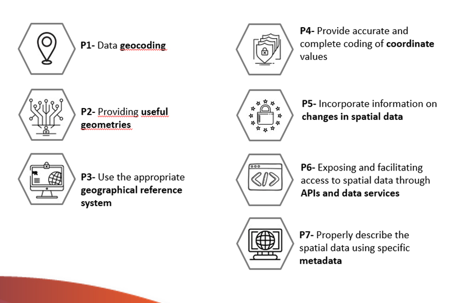
It then compiles a set of guidelines to facilitate the efficient publication of spatial data on the Internet, taking into account the international standards of the International Organization for Standardization (ISO). The guidelines detailed in this guide are:
Finally, a series of references, specifications, formats, standards and tools of direct application for the publication of Spatial Data are included.
The following elements are also included throughout the guide: references to the European INSPIRE Directive as a catalyst for sharing geographic resources in Europe and guidelines for describing spatial information derived from the Open Data metadata standards, DCAT and GeoDCAT-AP.
Other materials of interest
Although the primary scope of this document is oriented towards the publication of spatial data, it should not be forgotten that the application of all good practices linked to data quality in general is essential for their effective re-use. In this sense, it is advisable to complement this guide with the reading and application of other guides that provide guidance on the application of guidelines to ensure the publication of structured quality data, such as the Practical Guide for the publication of tabular data in CSV files and or using APIs.
You can download the Practical Guide for the Publication of Spatial Data from the following links:
Noticia
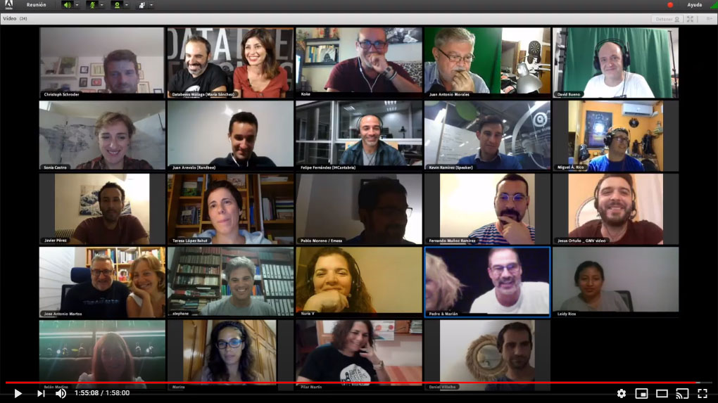
After having been postponed due to the confinement before the Covid-19, last Thursday 24 September the XVII edition of Databeers was held by videoconference, in the framework of the Hackaton Copernicus Malaga. The event could also be followed by streaming via Youtube, maintaining the open and free character of the community meetings, which started in Malaga five years ago. This new format aroused the interest of the audience, with more than a hundred people registered and a wide repercussion on social networks.
A new format with many advantages
Held in the context of the Hackaton Copernicus Malaga, this edition of Databeers focused on the projects and applications based on open data and services from the European Earth Observation Programme Copernicus.
There were five talks, all of them of short duration, informative tone and close to pecha-kucha format, given by prestigious national and international experts. A tasting of different varieties of beer was interspersed with these talks. San Miguel, a brand that has supported Databeers Málaga since 2018, brought the beers to the homes of those attending the event.
The event began with a presentation by María Sánchez, coordinator of the Initiative, who highlighted that this edition meant a great challenge in terms of organisation, given the need to carry out the event safely, but without losing its essence "through a screen, beer and networking included, differentiating us from the many webinars held nowadays". Although - commented Sánchez - the screen limits the interaction and experience that takes place in a bar, the virtual format opens up new possibilities, and made it possible to have speakers from different geographical locations and to connect many people beyond Malaga.
5 interesting talks on applications of Copernicus data
The opening speaker for this Databeers Málaga Copernicus special was Kevin Ramírez, Copernicus coordinator at Climate-KIC, who showed the potential of the initiative and its data as a tool to support a sustainable future. He was followed by Felipe Fernández, head of the Information Technology and Supercomputing Group at IHCantabria, who shared the results of the ApliCop project, designed to identify the actors in Copernicus Spain and to promote their collaboration and innovation through projects with data, some of which we have already covered in this article.
In this sense, from GMV Aerospace and Defence S.A.U., Jesús Ortuño and Julia Yagüe presented their work with remote data for sustainable forest management, while Juan Arévalo Torres, director of the Malaga-based company Randbee Consultants, focused on the way in which content and stories can be constructed, through storytelling and different visualisation techniques, to make the data attractive and understandable for citizens.
The event was closed by Sonia Castro, coordinator of open data at the public entity Red.es, who explained to those present the role of the Aporta Initiative in promoting interaction and citizen participation in the generation, use and reuse of open data. During her presentation, she toured the different sections of datos.gob.es, highlighting its usefulness for users who want both to locate new datasets and to identify use cases and keep up to date with all the new developments in the open data ecosystem in Spain. She also highlighted the guides we offer users and the interaction channels through which they can send us their requests and suggestions.

As usual, the event was recorded thanks to the collaboration of David Bueno (CEMI Málaga) and is available through the Databeers Málaga Youtube channel. Recordings of the talks and presentations used will soon be shared via www.databeersmlg.com. In this space you can find a lot of material, from this and other events, whose license allows its use and reuse. It is a good way to generate knowledge beyond the face-to-face events and the local environment.
Evento
For the eighth consecutive year, NASA organizes Space Apps, an international hackathon, where participating teams will have to solve real challenges related to Earth observation.
What does it consist of?
Programmers, scientists, storytellers, designers, and anyone interested in space science and data exploration can share their knowledge to design innovative solutions that respond to issues related to different categories:
- Earth's oceans
- Our moon
- Planets near and far
- To the stars
- Living in our world
- Invent ypour own challenge
To respond to these challenges, participants will have to use free and open data sets available in the NASA open data portal.
The solutions to the challenges can be technological, scientific or even artistic: from designing a low-cost method to provide internet connection in remote areas or improving NASA's predictive models, to creating a game that allows customizing stars and planets or devising mechanisms that help to better communicate the rising sea levels.
When and where?
The hackathon is celebrated on the weekend of October 18-20 in different cities that will receive the participants simultaneously. In the case of Spain, the events will take place in Alicante, Almería, Burgos, Madrid, Murcia, Salamanca, Seville, Valencia, Valladolid and Zaragoza. However, citizens can still hack virtually from just about anywhere on planet Earth.
Although citizens can participate independently, it is recommended to be part of a team.
Why participate?
In 2018, more than 18.000 people from 75 countries and 200 cities around the world participated in the Space App.
The advantages of participating in a hackathon are multiple. On the one hand, it allows expanding the experience in a specific area, improving creativity and promoting the acquisition of new technical skills. On the other hand, having to work in -often multidisciplinary- teams helps to develop some of the so-called soft skills, such as organization or effective communication.
If you are interested in participating in the Space App 2019, you can register through the following link.
Entrevista
Copernicus is the Earth observation program of the European Union. Through 6 thematic services, and the images provided by its satellites, Copernicus provides complete, free and up-to-date geospatial data that helps the monitoring and management of the territory and the planet both at European and worldwide level.
In datos.gob.es, we have interviewed Nuria Valcárcel, Deputy Assistant Director (Observation of the Territory) of the General Directorate of Geodesy and Cartography, in the D.G. National Geographic Institute (IGN) of the Ministry of Development, an organization that represents Spain in the Copernicus Users Forum, for the monitoring and evolution of the program, together with the Ministry for Ecological Transition (MITECO).
Earth observation data, such as those linked to the Copernicus project, always awaken great interest. What are the reasons?
Copernicus geospatial data are essential as a decision-making tool in the current digital economy and government systems. These data can be used to analyze and monitor phenomena due to climate change, and help us find solutions. Its potential is also enormous in matters related to safety, transportation, emergency management, sustainability assessment...
There are many organizations that, aware of the current context, have highlighted the importance of this initiative to achieve the Sustainable Development Goals (SDGs), such as the United Nations Organization or the European Commission. The United Nations, in its document “Transforming our world: the 2030 Agenda for Sustainable Development”, indicates that national institutions should promote the use of Earth observation data and geospatial information, to follow up on the 2030 Agenda.
Specifically, what kind of data and information does Copernicus provide?
Copernicus data has 2 large components: on the one hand, the information obtained via satellite, such as the Sentinel constellations, and on the other the in-situ component, that is, any data not coming from satellites. For example, air quality data, water quality data in rivers and reservoirs, wave and sea level information through buoys, tide gauges, orthophotographs and digital elevation models ... In the case of Spain, these data are provided by different national organizations such as IGN, MITECO, AEMET or State Ports, among others.
Through the Copernicus hub you can access and download these data. The information obtained through Sentinel satellites is available for use by any citizen, but when we talk about the rest of the on-site data, we find differences according to the data policy of each country. In the case of Spain, it should be noted that we have really been pioneers in open data policies and much of the information we generate is available through Copernicus' own download platforms or national platforms.
Who are the main users of this type of data? Could you give an example?
Public administrations are the main users of Copernicus, but an increasing number of companies rely on these data to generate new opportunities and improve their competitiveness, as well as universities and research centers.
The IGN and other Spanish administrations are beginning to work with large and small Spanish companies to collaborate in the generation of data for Copernicus, but we also try to boost its reuse more and more. For example, for water management or smart agriculture, since they facilitate continuous monitoring of the state of the crops, allowing water resources to be optimized. As a concrete example, we can talk about the DIANA Project, in which the company AGRISAT and the Andalusian Federation of Irrigation Communities of Andalusia (FERAGUA) participate, to generate an innovative commercial services platform, based on Copernicus Earth Observation data and other sources, for the identification of illegal irrigation areas and the estimation of volumes of water extracted.
Forest management can also greatly benefit from Sentinel satellites and Copernicus data. This is the case of AGRESTA and its FORESMAP application, which combine satellite data with others data sources such as the Lidar provided by the IGN, to provide an online forest inventory calculation. This application has been awarded at the 2018 Copernicus Masters CGI Big Data Business Challenge.
Another area with great potential is marine services, for the sustainable exploitation of coastal resources, port management, or the optimization and safety of trade routes. Here we can mention NOLOGIN as an example. It provide a (web and mobile) real time application and predictions for decision making in system ports, based on Copernicus data, with an alert and report management interface.
And regarding public administrations, do you know any AA.PP. that intensively use Copernicus project data?
There are many experiences. To highlight some examples, the IGN provides Copernicus data directly through the Download Center and makes extensive use and dissemination of Sentinel satellite images through the National Remote Sensing Plan. These data are also used by the IGN to enrich the system for monitoring changes in the terrain, for example, to assess volcanic risk.
The data of the marine operational service are very useful for State Ports. knowing how marine currents evolve, and improving their predictive models is possible thanks to them
For its part, AEMET participates in the generation of Copernicus data and services in relation to Atmosphere and Climate Change, as a member of the European Centre for Medium-Range Weather Forecasts, which benefits Spanish institutions and scientists participating in numerous research programs.
The Spanish Agricultural Guarantee Fund, the National Parks Network, the General Water Directorate, the Autonomous Communities, as well as a large number of universities and study centers also use these type of data.
What are the main challenges and barriers to the reuse of Earth observation data?
The challenges that reusers have to face could be summarized in 4 areas.
In the first place, some technical knowledge is required to work with Copernicus data. Although sometimes we find some data or services easy to use by non-expert users, in other cases advanced capabilities are needed to locate and understand the information. Copernicus Program is making an effort to train professionals, through free courses, while working on the creation of environments where data are easily located and easy to use.
Secondly, we could talk about the coordination between the different levels of European administration (local, regional, state ...). A common effort must be made to generate better data, avoiding duplication, and for this, coordination between European and national institutions is essential. Currently, there are coordination mechanisms already established, but there are areas for improvement.
Thirdly, it is necessary to improve the interaction with users, to better understand their needs and thus be able to assess whether the Copernicus program is responding to those needs. And these needs are changing and require constant adaptation. Through the Spanish Users' Committees and Forum, the National Services Coordinators, and the Relay and Academy Networks, we are making a strong effort to approach as many users as possible, to work together in a common goal.
Finally, we cannot forget the need to encourage data to be interoperable, to meet common standards and to be harmonized. For example, the Mediterranean coast, and the different phenomena and dynamics that affect it, have to be monitored as a whole, and for this we need a common pan-European data, also harmonized with the national data that each country manages. Again, coordination between administrations is essential to achieve this goal.
One of the challenges you have mentioned is the user´s lack of knowledge about Copernicus data availability. What concrete actions are the IGN taking to publicize Copernicus data?
The European Union organizes different activities to encourage the use of Copernicus data in private companies. This is the case of the Copernicus Master competition, hackathons, the acceleration programs (Copernicus Accelerator) or business incubation (Copernicus Incubator). These types of activities, often aimed at entrepreneurs and start-ups, seek to support new ideas that involve the creation of services and commercial applications related to Copernicus.
In addition, the IGN, together with the Ministry for Ecological Transition (MITECO), in the Copernicus Users Forum, and also with representatives in the Copernicus Committee (the Ministry of Industry, Commerce and Tourism and the Centre for Technological and Industrial Development), works very actively with the different user groups in Spain. We are part of the Copernicus Users Forum, we carry out meetings and workshops for specific services and themes (Territory, Marine, Agriculture, Smart Cities, etc.), we encourage the participation of universities in Copernicus activities and proposals… In short, we seeks to generate a favorable ecosystem that facilitates the use of Copernicus.
Finally, could you tell us what your future plans are?
The Copernicus program is open to continuous review of requirements. In this regard, I would highlight two issues on the agenda.
First, the synergies between Copernicus and Galileo, the European Union navigation system, that the Ministry of Development also lead in Spain. The integration of both systems allows real-time monitoring of atmospheric phenomena to determine how vehicles move in cities. In this way, the constant impact of greenhouse gas emissions from vehicles could be monitored. It could also be used in matters of security, surveillance of natural hazards, etc.
On the other hand, the European Commission is directing its policies towards sustainability and the fight against climate change. In the new Copernicus operating cycle (2021-2027), some of the areas to be promoted are the monitoring of greenhouse gases or the monitoring of Polar Regions (snow and ice level). The civil security approach will also be expanded and the use of Copernicus data will be encouraged not only in Europe, but also in other regions, such as Latin America or Africa.
Evento
The tenth edition of the Iberian Spatial Data Infrastructure Conference will be held in Cáceres on October 23, 24 and 25. On this occasion, the event will focus on spreading the role of the local IDE as a meeting point between administrations, companies and citizens.
Under the title "Local IDEs, bringing digital information to citizens", various technical sessions, workshops and round tables will be held. They will address topics such as the implementation of INSPIRE, the challenges and opportunities of local nodes, smart cities or new developments, web services and thematic applications of spatial data. And of course, the importance of open data will also be analyzed by the Aporta Initiative.
Jose Ignacio Sánchez, Deputy Director of Digital Economy of Red.es, will take part in the opening of the event with the presentation “Vision of the IDEE and INSPIRE by the open data portal of Spain”. This slot will address the actions in place in coordination with the Spanish geographic information access portal (IDEE). Likewise, the strengths of the INSPIRE directive will be analyzed as inspiring for the promotion of open data policies in the public sector at European level, including Directive (EU) 2019/1024, of June 20, 2019, regarding the reuse of public sector information. Once the presentation is finished, the technical session “Open data and e-administration” will take place, moderated by Marta Codinachs, from the Barcelona Provincial Council. This session address the data models shared between administrations and the mechanisms to measure the impact of open spatial information, showing examples and success stories, such as the SIG corporativo Local Space in the Cartagena City Council.
On the second day will address issues such as “Environmental IDE applications” or “Differences between official and unofficial geographic information”, a round table that will be moderated by Emilio López, of the National Center for Geographic Information (CNIG).
The last day will be a meeting of the ILAF OGC forum and the IDEE working group, where the LISIGE action plan or the good practices that an IDEE must comply with will be discussed.
The full agenda is available through this link.
The attendance to the event is free, but it is necessary to register previously.
Noticia
GeoDCAT-AP, available on the JoinUp portal, is the geospatial extension of DCAT-AP vocabulary designed for the European data portals, whose first working version was released in late 2015 by the working group belonging to the ISA programme.
Geographic information has always played an especially important role in open data movement. It is of vital importance because most information has a spatial component, both from the point of view of mapping and georeferencing of entities (such as POIs) as well as in domains related to the environment and agriculture. In fact, its impact is transversal, and almost any domain can be the subject of spatial analysis. For this reason, it is essential to facilitate the re-use of geographic information.
In this regard, the European INSPIRE initiative (through its Directive 2007/2/EC) promotes the creation of a European spatial data infrastructure, through web platforms known as IDEs, which provide information through APIs based on web services, according to the standards set by the Open Geospatial Consortium.
Moreover, these IDEs follow the technical specifications of INSPIRE metadata, which include rules for description of resources based on ISO 19115 (geographic information metadata) and ISO 19119 (service metadata and catalogues). In this context of interoperability, it is essential to be able to discover automatically new spatial datasets through descriptions (metadata) published by different INSPIRE IDEs . And this is where the GeoDCAT-AP extension is particularly important.
The goal of GeoDCAT-AP is to provide an RDF syntax for binding together INSPIRE schema metadata and ISO 19115, in a way that ISO19115/INSPIRE metadata records can be automatically transformed into RDF harmonized, easily extensible representations.
To the extent that GeoDCAT-AP extends DCAT-AP vocabulary, its main purpose is to provide a set of classes and properties for representing spatial metadata. The working line followed in this first version makes it clear that the intention is to align GeoDCAT-AP with already existing RDF vocabularies, such as Dublin Core and SKOS Core, while at the same time aligning the representation of concepts with the representations of controlled vocabularies such as GEMET, the topics of INSPIRE itself and, of course, Eurovoc.
Nevertheless, it is necessary to clarify that the mission of this vocabulary, GeoDCAT-AP, is only to offer new more expressive mechanisms for publication and discovery of spatial metadata. In no case does this specification replace the INSPIRE directive, nor the regulatory scheme for INSPIRE metadata.
Until now, the most significant example of GeoDCAT-AP adoption is the European Open Transport Net project, a collaborative network formed by cities and regions to add, harmonize and display geographic open data from all areas of European Union administration. This initiative also provides a number of tools for access and analysis of data in order for third parties to re-use the information and develop new products and services. In this case, GeoDCAT-AP is used in conjunction with DCAT-AP to describe geographic datasets, allowing users to search and access information through visual interfaces quickly and simply.
A report by the Open Data Institute on the re-use of open data by enterprises in the UK shows that geospatial data is the information most reused by the British infomediary sector. Up to 57% of the companies surveyed use this resource for their business. These results are another example of the value of geospatial information which, thanks to the efforts of the European community in the development of extensions such as GeoDCAT-AP, can be used to develop initiatives, services and products that impact positively on society.