Noticia
Thanks to the efforts of the 160 organizations that publish data on the datos.gob.es platform, the National Open Data Catalog has reached 50,000 published datasets. Among them, we find datasets published by all levels of administration (state, regional and local), divided into the 22 thematic categories defined in the Technical Interoperability Standard (NTI, in Spanish acronyms), such as Public Sector, Society and Welfare, Environment or Economy.
In this article we want to zoom in on some of these datasets published by organizations belonging to the General State Administration (known as AGE in Spanish), based on three criteria:
- Data that receive a higher number of visits.
- High value and georeferenced data.
- Data with a high potential for reuse.
Most requested data
The Catalog's datasets recorded an average of more than 100,000 visits per month during the past year. These are some examples of the most visited datasets.
- Publisher: Ministry of Industry, Trade and Tourism
- Format: CSV, XLS, KML, XML, JSON and PNG.
Contains information on the price of the different types of fuels in Spanish gas stations, such as gasoline, diesel, liquefied petroleum gases or natural gas (both compressed and liquefied). It also includes the address and opening hours of the establishments.
This dataset is widely used in applications that report on fuel price variations, such as GeoGasolineras, from the Ministry for Ecological Transition and the Demographic Challenge, Search for cheap gas stations in Spain or Gasoline prices on the road, both from private companies.
- Publisher: Ministry of Health
- Format: CSV, HTML, PDF
It collects daily data on cases and incidence of the disease COVID-19, caused by the SARS-CoV-2 coronavirus. It also offers the historical series of cases by Autonomous Communities and Provinces. The data come from those reported by the health services of the Autonomous Communities themselves.
These data have been used to create different visualization tools that facilitate the understanding of the disease, such as the scorecard of the Ministry of Health itself, but it should be noted that there are numerous efforts at provincial and even local level in this area, some of which are included in this website.
- Publisher: Ministry of Territorial Policy and Public Function
- Format: RDF-XML y XLSX
DIR3 codes are three codes assigned respectively to the organizational units, their associated offices and the economic and budgetary management units of a public entity.
This set of data provides a unified and common inventory for the entire Administration, facilitating the distributed and co-responsible maintenance of information.
- Publisher: National Commission for Markets and Competition (CNMC)
- Format: XHTML, ZIP
This is a detailed list of information relating to the different telephone numbering ranges. It also includes the services provided by the teleoperator and the maximum prices, if regulated.
In addition to offering all the data from the CNMC's Telecommunications Numbering Registry by downloading the files in compressed format, the CNMC also provides access to a search engine. On the website of the National Commission for Markets and Competition, a search tool can be accessed to find out directly to which company each telephone number belongs.
High-value geo-referenced data
A georeferenced database is one where the exact location of its elements is defined based on a coordinate system. The referenced data allow us to locate the information on maps and to superimpose layers of information that allow us to perform more in-depth analyses. Below are 4 examples of georeferenced data that you can find in datos.gob.es.
- Publisher: Ministry of Transport, Mobility and Urban Agenda
- Format: XLS y ODS.
It offers urban information on 4,883 municipalities, including 100% of urban areas. Through a cartographic viewer, users can access the graphic and alphanumeric content of the Urban Information System.
This dataset allows a homogeneous and comparable approach to the Spanish urban reality. Among other uses, it offers information of interest in the field of decision making and urban planning.
- Publisher: National Center for Geographic Information
- Format: SHP
It includes geographic information related to municipalities and population entities. It includes the names, coordinates, population, etc. of each one of them.
The reference sources for the elaboration of this database are the Registry of Local Entities (MINHAP), the National Institute of Statistics and cartographic databases of the National Geographic Institute.
- Publisher: Geological and Mining Institute of Spain
- Format: MDB, XLS, HTML, JSON, KMZ, XML, SHP.
This is a database of seismogenic zones of the Iberian Peninsula and its territories of influence. Its use is intended for the calculation of the update of the hazard and earthquake risk map in Spain.
In this viewer you can see in a simple way the different points and know their level of danger.
- Publisher: National Parks Autonomous Agency
- Format: SHP, HTML
It collects the cartography of the natural vegetation and geological systems of the Spanish National Park Network. As it is homogeneous information, it allows comparisons to be made throughout the territory.
A cartographic viewer has also been developed that includes additional information on their location or the species of fauna and flora that inhabit them.
Data with high reuse potential
In datos.gob.es you can find versatile data with a multitude of formats that facilitate its reuse, many of them also georeferenced. Here are some examples:
- Publisher: National Library of Spain
- Format: CSV, HTML, JSON, ODS, plain, XML
Contains descriptions of Spanish libraries and documentation centers in any country. It includes information about their location, type of collection (books, reports, newspaper articles, maps, engravings, etc.) or the type of library (public, school, etc.), among other aspects.
Very useful for integration into tourist or citizen information applications that show the location of various services in a centralized way.
- Publisher: National Center for Geographic Information
- Format: SHP, atom, WFS, WMS
It includes geographic data related to municipal, provincial and autonomic precincts and their boundary lines. The scale used is 1:25,000.
It is very useful to know the space occupied by our towns and to know to which municipality a specific space belongs.
- Publisher: Guadalquivir Hydrographic Confederation
- Format: HTML, ODS, PNG, SHP
It provides the history of drought and water scarcity indicators in the Guadalquivir, Ceuta and Melilla river basin districts, as well as a map of the current status, with a monthly update frequency.
This is an essential dataset for monitoring the situation and promoting informed decision making.
- Publisher: National Institute of Statistics
- Format: CSV, JSON, XLSX, XLS, PC-Axis
The National Institute of Statistics offers open access to a large amount of data extracted from the surveys and studies it carries out periodically. One of them is this dataset containing information on the resident population in Spain. The data can be filtered by date, sex, generation (age on December 31), nationality and place of birth. The INE website includes a search engine to access the data more easily.
This dataset allows to know the characteristics of the Spanish population, and can be crossed with other data (economic, health, etc.) to generate a deeper knowledge of the society.
160 publishing organizations
This is just a small sample of some of the datasets available, but many more can be found in the National Catalog.
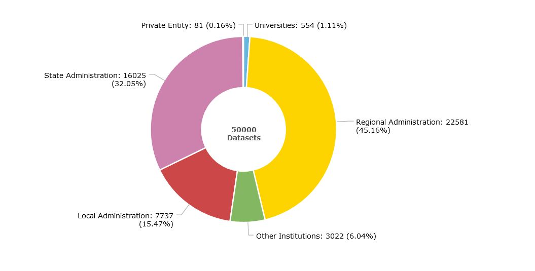
We currently have 160 publishers: 83 belonging to the General State Administration, 17 Autonomous Communities, 44 local entities, 11 universities and 1 private entity. In addition, there are 5 State institutions that do not fall into these categories, such as the Parliament of the Canary Islands.
The organizations that publish the most data in the Catalog are the autonomous administrations (45%), followed by the State (32%) and local administrations (15%), as shown in the following graph. You can obtain more information on the catalog through the scorecard.
From datos.gob.es we invite you to explore our catalog. If you have any questions, you can write to us at contacto@datos.gob.es.
Noticia
A few weeks ago, we picked up on an article what were the most demanded datasets among all those offered by the Autonomous Communities, and that met certain standards that encouraged their reuse.On this occasion, we would like to focus on local entities. In order to draw up the list, we have taken the same questionnaire as a reference, where they were asked to identify in a simple way sets of data published by their organisation and which, from their point of view, meet the aforementioned characteristics. The Provincial Councils and Municipalities that have collaborated are:
All these organizations share data openly and in formats that facilitate their use by companies, researchers or the general public, through different spaces, accessible in the previous links. Most of the participants are local councils, but there are also two provincial councils. Provincial councils play a very important role in the open data ecosystem, as they promote the opening of data in small town councils, which without them would not be able to carry out these tasks. They are fundamental when it comes to highlighting interesting and useful regional data.
These 17 local entities are just a small sample of the open data ecosystem at the local level in Spain, but the presence in our country of this type of project is much greater. Specifically, in datos.gob.es we have identified 230 local initiatives open data.
Transport, environment and public sector, the most demanded data categories
From the responses of the organizations participating in the survey, it is extracted that the most demanded local data sets are the following:
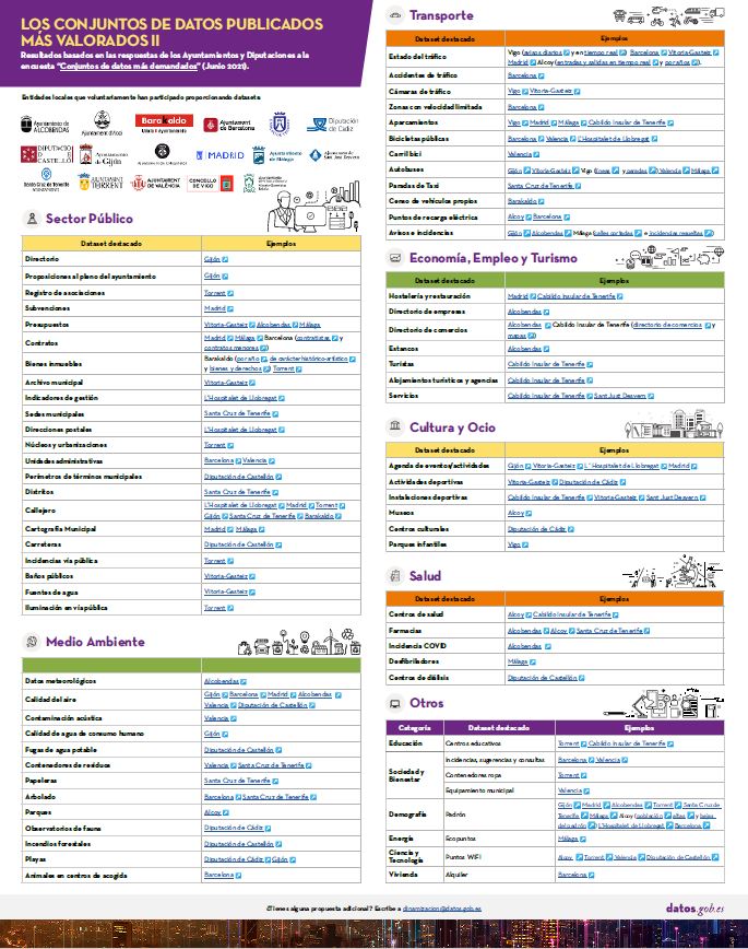
Click here to see the infographic in full size and in its accessible version.
Three categories stand out: transport, environment and public sector data. Three fundamental sectors to achieve efficient and sustainable cities.
In the case of transport data, those related to the state of traffic, parking lots and public services (such as public buses or bicycles) stand out, key to promoting an environmentally friendly transport system, in line with the marked on the "Sustainable and smart mobility strategy". These data are usually provided in real time, facilitating their re-use and helping public administrations, private companies and individuals to manage mobility more efficiently.
The air quality data are the most prominent in the environment section, highlighting the growing concern about pollution in our cities. Do not forget that according to the study Air quality in the Spanish State during 2020, prepared by Ecologists in Action, 42 million people breathed polluted air during the past year (that is, 88.4% of the population), which caused 30,000 premature deaths. Public agencies are increasingly aware of this situation, and carry out air quality assessments on a regular basis, which has led to the installation of more monitoring stations. Spain currently has 616 monitoring stations for official assessment, of which 535 measure NO2 and 475 record information on PM10 levels, generating valuable data for reutlisation and policy decisions.
In the environment category we also find datasets related to garbage management, noise pollution or trees in cities.
Regarding the public sector, we find a large number of datasets related to urban planning and infrastructures, such as the street map, municipal cartography or real estate. Datasets related to the activity of Public Administrations and their transparency, such as contracts, budgets or subsidies, also stand out.
Other prominent categories are the economy, employment and tourism, with datasets such as the Directory of businesses or hotels and restaurants; culture and leisure, where we find datasets on sports facilities or the events agenda; or health, with information on health centers, pharmacies or covid data. Finally, data on education, society and well-being, demography, science and technology, and housing have also been collected.
It should be noted that a large majority of the data sets highlighted by the Town Halls and Provincial Councils are included in the guide. Open data FEMP 2019: 40 datasets to be published by Local Entities, elaborated by the Federation of Municipalities and Provinces of Spain(FEMP). It contains a series of datasets considered priority and that should be published openly by local organizations, as well as instructions to do so in a harmonized way that facilitates interoperability.They also coincide with the vocabularies promoted by the Ciudades Abiertas project. It is, therefore, an opportunity to advance in the standardisation of the way in which data is published.
Why is local open data important?
The possibility of having local data, updated and differentiated by municipalities (or even districts or streets), allows to know the reality of each geographical area in a more concrete way. It allows us to appreciate differences and needs, and based on this, make more accurate decisions that help promote public policies aligned with the demands of citizens.
This data can also be reused, both by the administration itself and by third parties, to launch products that bring public services closer to citizens. This is the case of transport applications, which inform us about the most efficient and fastest way to reach our destination; or apps to recycle, which tell us where the closest waste containers are.
In short, the publication and reuse of open data not only benefits citizens, but also administrations when it comes to performing a more efficient management.
Noticia
The Aporta initiative, in its desire to promote harmonisation and seek synergies between the various publishers of open data in our country, has launched an initiative to find out which datasets are most in demand among those offered in open format according to standards that facilitate their reuse.
To this end, we share a questionnaire and invite different public organisations to identify up to 10 datasets that from their point of view meet the aforementioned characteristics, preferably published on datos.gob.es. In this article we will focus on the responses provided by the Autonomous Communities.
Nine Autonomous Communities took part in the questionnaire:
As can be seen in the links above, all of them have consolidated and sustainable open data portals in place. They have also shown their commitment to the openness and reuse of public data through various strategies and action plans included in the IV Open Government Plan.
You can see the specific results of the questionnaire in the following infographic:
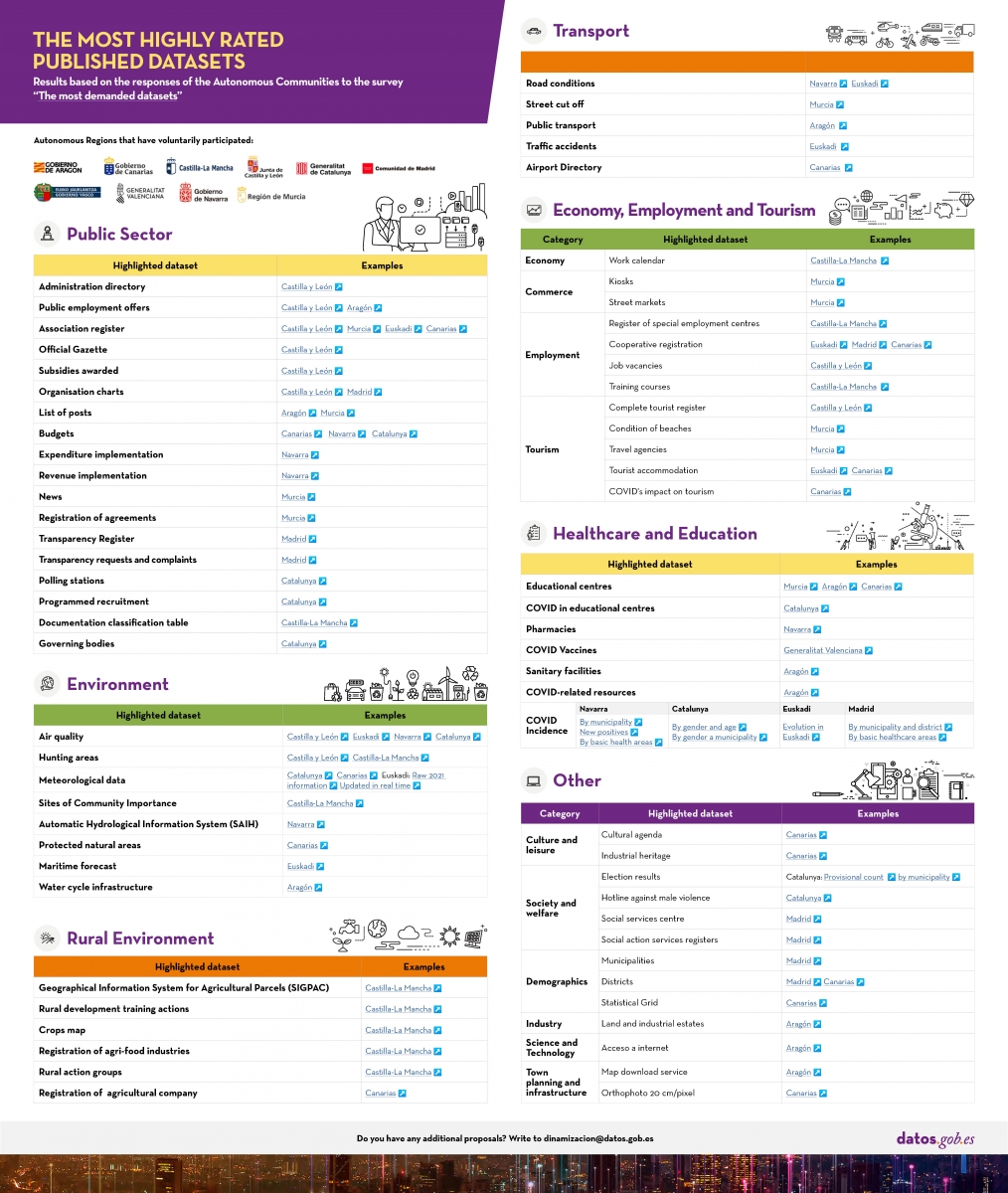
Click here to see the infographic in full size and in its accessible version.
It can be seen that the datasets that stand out as a priority are those related to the public sector: budgets, expenditure, hiring, subsidies or organisation charts showing jobs and roles in the administration, among others. Public employment offers and the official gazette of each community also stand out.
Secondly, environmental datasets, such as weather forecasts or air quality data, which are very necessary when it comes to making predictions that allow us to fight against climate emergencies, stand out. Closely linked to this category we also find rural environment datasets, such as the Geographic Information System for Agricultural Plots (SIGPAC), with information on agricultural plots declared by farmers and livestock farmers and through which farmers and livestock farmers must make applications for aid.
Datasets related to the economy and employment, where we have included fundamental sectors for our country such as commerce or tourism, complete the top 3 most demanded thematic categories. Job offers, training courses, tourist establishments or beach guides are just some of the examples of datasets included in this category.
Transport data, such as road conditions or those related to public transport, also stand out. And those linked to education and health. Given the current global pandemic situation, it is not surprising that the autonomous communities have also highlighted the importance of COVID data, which are essential for decision-making. These data have been among the most in demand in recent months due to the health situation.
It is worth noting that the work carried out by ASEDIE in promoting the opening of the datasets of associations, cooperatives and foundations (an action they have come to call top 3 ASEDIE) has borne fruit, as the majority of the communities participating in the questionnaire have not only opened them, but have also indicated that they consider them to be a priority.
With this questionnaire, we have learned about some of the datasets considered a priority by the Autonomous Communities. The challenge now is to promote their harmonisation, so that the different bodies publish the same information structure in a way that facilitates their interoperability. Whenever possible, access to data should also be facilitated by means of APIs, with priority being given to data provided in real time or with a very high update frequency.
Do you agree with the highlighted datasets? Let us know what you think in the comments.
Noticia
Data related to mobility and transport are among the most demanded by users and re-users. The European Union itself considers them as high-value data, according to the preliminary classification included in Directive (EU) 2019/1024, due to their "considerable benefits for society, the environment and the economy".
The opening and re-use of transport data brings benefits for all:
- Public bodies. Detailed information, often in real time, helps public authorities to make decisions aimed at efficient infrastructure management and service improvement. It also helps to reduce costs, as demonstrated several years ago in the UK’s Transport for London (ODImpact) study by the GovLab.
- Private transport companies. Private public transport operators, mobility service providers and private infrastructure managers also need reliable information to understand the different variables that affect their business and to act accordingly, adapting their services to users' needs.
- Businesses and re-users. The openness of transport data stimulates economic growth. There is a huge market for applications based on transport data. You only need to take a look at the applications section of our portal to see that almost 20% of the applications highlighted are related to this category: applications that provide information on traffic conditions, public service timetables, the best routes to reach the requested destination, etc.
- Citizens. Thanks to these solutions, citizens can, for example, plan their journey in advance, thus saving time, and benefit from more efficient, accessible and sustainable transport.
What kind of data related to mobility and transport can I find in datos.gob.es?
At datos.gob.es we have an extensive catalogue of data related to mobility. There are currently 1,820 datasets grouped under a category called "Transport", following the cataloguing rules set out in the Technical Interoperability Standard (NTI, in its Spanish acronym). Based on this standard, this category includes communications and traffic datasets, such as data on traffic control, registrations, accidents, civil aviation, land transport (road and rail) or merchant navy, among others.
Most of these datasets are in CSV (1,333) and JSON (1,113) format, facilitating their re-use. There are state, regional and local data. The publishers that share the most data of this type are the National Statistics Institute (INE), Gijón City Council, the Autonomous Community of the Basque Country and Madrid City Council.
The most important of these datasets are listed below, together with the format in which they can be consulted:
At the state level
- INE. Movement of people by mobility areas. Daily. National. CSV, XLSX, XLS, HTML, PC-Axis, JSON.
- Port Authority of Barcelona. Railway services of the Port of Barcelona. RDF-XML.
- Port Authority of the Balearic Islands. Maritime traffic forecast. CSV, HTML.
- Renfe – Operator. List of Alta Velocidad, Larga Distancia and Media Distancia stations. CSV, XLSX.
- Central Trafficking Office. Driver census. CSV, XLS.
- Central Trafficking Office. Traffic accidents with victims. XLS
At Autonomous Community level
- Autonomous Community of the Canary Islands. Vehicles registered according to type of vehicle and services by Canary Islands and time periods. HTML, JSON, PC-Axis.
- Basque Government. Transport and mobility resources in the Basque Country. KML, Api, GeoJSON, XML, RSS, JSON, XLSX.
- Government of Catalonia. Monthly electrified and hybrid vehicle registrations in Catalonia. XML-APP, CSV, JSON, RDF-XML.
- Government of Catalonia. Real time road incidents in Catalonia. RSS, XML-APP.
- Government of the Balearic Islands. Mallorca Car Rental Agencies. RDF-XML, CSV, XML-APP, JSON.
- Government of Aragon. Mobility analysis with Big Data. CSV, JSON, XLS, XML-APP.
- Castilla y Leon Government. Statistics on passenger cars. CSV, RDF-XML, JSON.
- Andalusian Government. Data from the Andalusian Network of Transport Consortiums. JSON.
- Government of Valencia. GTFS of itineraries and timetables of intercity public transport services by bus. ZIP.
At local level
- Madrid City Council. Bicycle. Quiet streets. KML, ZIP, XLS, CSV.
- La Palma Island Council. Road and track infrastructures. HTML, JSON.
- Barcelona City Council. Surface parking spots rates' information in the city of Barcelona. CSV.
- Santiago de Compostela City Council. Real time traffic observations. CSV, GML, JSON.
- Alcoy City Council. Charging points. KML, ZIP, JSON.
- Terrasa City Council. Petrol stations. CSV.
- Santander City Council. TUS sales/recharge points. HTML, RDF-XML, CSV, RDF-Turtle, RDF-N3, JSON, XML-APP, JSON-LD, Atom.
- Caceres City Council. Caceres Monumental City car park. XLS, GeoJSON, JSON, RDF-Turtle, CSV, SPARQL.
- Pamplona City Council. Car park occupancy in real time. XML-APP.
In addition, the Ministry of Transport, Mobility and Urban Agenda is publishing new datasets. Specifically, the data on mobility in Spain during the COVID-19 pandemic at national level. These data, which are now openly available on the Ministry's website, are the result of the Mobility Study with Big Data carried out to assess the effectiveness of the mobility restriction measures adopted during the state of alarm and to support decision-making.
Some examples of re-use of mobility-related data
As we saw earlier, data related to mobility is a great raw material for the impulse of ingenuity and creativity in the form of new products and services. The best known are the applications that provide information on the timetables of public transport services or the most suitable routes and means of transport for each journey, but there are many more.
In our section on reusing companies we find some organisations that have taken advantage of this data to develop new businesses. One example is Canard Drones, which develops and markets solutions for the verification and calibration of navigation aids (NAVAID) and runway inspection, using public data. Another example is remOT Technologies and its RuralMaps application, which facilitates GPS navigation on roads in rural environments by indicating the optimal and fastest route to reach the desired destination, saving cost and time for agricultural technicians and emergency services.
Transport data can also be used to enrich tourism applications and improve the experience of visitors, who can find all the information they need to enjoy their stay (hotels, transport, points of interest, etc.) on a single platform. Or they can help to improve the architecture of cities: the data collected can be used to define spaces that are more suitable for the common good in cities, for example, the necessary width of pavements.
With the rise of smart cities, with IoT devices collecting data to manage assets and resources efficiently, we can expect more and more mobility data to become available. Data that can be queried, enriched with new data, and used to create valuable applications and services.
We live in a world where travellers' needs and habits are constantly evolving, and there is a growing demand for efficiency and flexibility in mobility options. Open data can help respond to this demand, while driving economic development.
Noticia
Care for the environment is an aspect that has been of concern to a large part of society for several years now. It is clear that we have reached a turning point that makes us see the need to act as soon as possible to avoid further damaging our planet. Therefore, we citizens must change our habits if we want to see a real change in this situation.
Recently we have seen how the new generations are the ones who are most aware of the need to take proper care of the environment at a global level. At this point, change becomes more than necessary and new technologies can play a fundamental role in helping us to take care of our planet.
Did you know that open data is very useful in overcoming environmental challenges? In addition to providing us with accurate information to understand the problem and to be able to search for effective solutions, open data allows us to implement solutions that raise awareness in society and make it easier for us to protect the environment.
Currently, in our portal you can find diverse content on applications related to the environment, cases of use of open data to fight climate change, in addition to 6,000 datasets related to this field.
Below, we highlight some of the environmental datasets that you can find in our catalogue to reuse and develop new applications and services that can drive improvements in this field.
These are the types of environment-related data you can find at datos.gob.es
In our portal you can find a wide catalogue of data classified by different sectors. The Environment category has different datasets that can help in the fight against climate change, deforestation or environmental degradation, threats faced by the whole world.
Of these datasets, the following are the most important ones, together with the format in which you can consult them:
-
At the state level
- Centre for Sociological Research (CIS). Ecology and environment. ASCII.
- Ministry of the Interior. Nature conservation: environment-related offences. XLSX.
- National Parks Autonomous Agency. Natural systems in national parks. SHP, HTML.
- Confederación Hidrográfica del Guadalquivir. Distribution of invasive species in the Guadalquivir river basin. HTML, WFS, WMS, SHP, KMZ.
- Renfe – Operator. Main sustainability indicators. XML, JSON, CSV, TURTLE, RDF.
- INE. Statistics on Waste Collection and Treatment. CSV, XLSX.
-
At Autonomous Community level
- Xunta of Galicia. Air quality data. XLS, JSON, RSS.
- Basque Government. Cartography of the Open Catalogue of Relevant Natural Spaces. SHP, WMS.
- Castilla y Leon Government. Camping area in natural spaces. GML, SHP, KML, CSV.
- Government of Aragon. Special Conservation Areas de Especial. JSON, CSV, KMZ, SHP, GML, XML-APP.
- Autonomous Community of Madrid. Reforestation. JSON, CSV.
-
A the local level
- Santander City Council. Environmental News. RDF-XML, XML-APP, JSON, RDF, CSV, Atom, RDF-Turtle, HTML, RSS.
- Cáceres City Council. Cáceres rubbish collection points. SPARQL, RDF-Turtle, CSV, XLS, JSON.
- Valencia City Council. Location of domestic oil containers. WMS, KML, GML, WFS, KMZ, OCTET-STREAM, JSON, CSV.
- Vigo City Council. Forest Parks (Points of Tourist Interest). CSV, JSON, KML, ZIP, XLS, CSV.
- Alcobendas City Council. Environment. Waste collection. ODS, XLS, XML, CSV, JSON.
- Madrid City Council. Clean Proximity Points. RSS, XLS, CSV.
Some examples of environmental data reuse
The power of datasets related to this field is of tremendous value. Thanks to them, it is possible to create new tools that facilitate aspects such as the care of the environment or the fight against climate change. An example of this is the National Air Quality Index, which makes it possible to check, in real time and in a simple way, the state of the air quality marked by the 506 measurement stations of the national monitoring network. Or Förecast, an application with real-time data on forest stocks that allows spatial-temporal analysis and thus optimises forest management.
Do you know of any company that uses this type of data or an application that relies on it to help care for the environment? Then do not hesitate to leave us a comment with all the information or send us an email to contacto@datos.gob.es. We will be happy to read you!
Noticia
We are currently in a context of digital transformation in which all sectors are in a process of adaptation with the aim of responding to the needs for improvement, agility and efficiency that society demands. One of the fields in which this change is most evident is the rural environment.
In the specific case of Spain, the change of paradigm is more than necessary due to aspects such as climate change or the depopulation of rural areas. The digital transformation of primary activities such as agriculture or livestock farming can contribute to solving these challenges, by attracting new professional profiles to areas with lower population density, and contribute to more efficient and sustainable crops.
Open data play an important role in solving these challenges through digital transformation, as the raw material for technological solutions that help to make better, more sustainable decisions. For this reason, we would like to tell you about the main rural environment datasets that you can find in our catalogue and reuse to implement applications and services that promote improvements in this sector.
What types of data related to the rural environment can I find in datos.gob.es?
In datos.gob.es we have a wide catalogue of data related to different sectors such as Tourism, Environment, Culture and Leisure, Economy, Transport, Health or Industry. The Rural Environment category includes different data catalogues related to Agriculture, Livestock, Fisheries and Forestry.
Currently, this category has more than 1,000 outstanding datasets. Among these datasets we can find national, as well as local and regional information. In this article, we have already talked about the datasets that the Ministry of Agriculture, Fisheries and Food made available to citizens, but there are many more in this category. Along with the ministries, the institutions that most publish this type of dataset are the Autonomous Community of the Basque Country, the Government of Catalonia and the National Institute of Statistics (INE).
Of these datasets, the following are the most important, together with the format in which they are offered:
-
At state level
- CIS. Spanish rural youth. XML, CSV, Json.
- Official INSPIRE Data and Services Catalog. Beach guide. MDB, KMZ, SHP, ASCII, XHTML.
- INE. Distribution of certified organic farming area qualified and or in conversion period. CSV, XLSx, XLS, Html, Json, PC-axis.
-
At Autonomous Community level
- Government of Catalonia. Agro-food industries in Catalonia. CSV, JSON, XML-APP, RDF-XML.
- Castilla y León Government. Agricultural statistics (Castilla y León). CSV.
- Government of Aragon. Agricultural regions of Aragon. CSV, XML-APP, JSON.
- Basque Government. Rural women in the Basque Autonomous Community by professional situation according to age group (%). CSV, XLS.
- Autonomous Community of Castilla-La Mancha. Agricultural training courses. XLSX, PDF.
-
A the local level
- Island Council of La Palma. Zoning and uses of the island of La Palma. HTML, CSV, JSON, GeoJSON, KML, SHP.
- Barcelona Provincial Council. Decline of the forest mass of the Maresme forests. PDF, ZIP, HTML.
- Vitoria-Gasteiz City Council. Risk of forest fires.PDF, OCTET-STREAM.
- Zaragoza City Council. Zaragoza City Hall Clean Points. GeoRSS.
The re-use of data from the agri-food, forestry and rural sectors
The reusable power of all these data sets is very valuable. They can be used to create valuable tools and services. Take the example of the Agricultural Plot Geographic Information System, SIGPAC, which "makes it possible to identify geographically the plots declared by farmers and stockbreeders, in any aid scheme related to the area cultivated or used by the livestock". This viewer was created to make it easier for farmers to submit aid applications and to monitor them. However, it should be noted that SIGPAC has also been used to develop applications and services that improve crop efficiency, such as Campogest or Cropti. Many of these applications also incorporate the data from the Register of Fertiliser Products, such as cultivAPP, which allows farmers to control the phytosanitary treatments applied in an easier way, from their own mobile device.
We can also find applications related to the forestry field, such as förecast, a tool that provides real-time data on forest stocks and allows for spatial-temporal analysis based on remote sensors and artificial intelligence. Or with a marked social character such as Plan Repuebla, a project that seeks to reactivate the rural areas of Castile and Leon.
You can see more examples of the reuse of agricultural data in the finalists of the 2019 Challenge, in our applications section or in this report.
From datos.gob.es we invite you to visit our data catalogue and discover all the datasets we have collected in the different sections.
Noticia
Education is one of the most influential factors in the progress of individuals and societies, promoting equal opportunities and the reduction of inequality through knowledge. But to achieve these advances, equitable and quality education is necessary. Open data can help achieve improvements in both directions.
The role of open data in education
Open data has different roles in education. On the one hand, they can serve as a basis for creating educational resources that facilitate more attractive learning. In any subject, students can be offered work based on the analysis and interpretation of information, which helps them to develop critical thinking. The use of open data is usually well received by students, as it boosts their motivation to work with real content and helps them to develop a data culture that is much needed in today's professional environment.
But in addition to being an educational resource, open data can also be used to drive improvements in the education system through the development of solutions and tools that facilitate effectiveness, efficiency and informed decision-making, responding to a wide range of challenges in the education system. This is the focus of the 3rd edition of the Aporta 2020 Challenge (in this article you can find a series of tips for implementing a solution of this type).
Open data on education
The educational data that institutions open up, and which can be used to integrate into this type of solution, are very diverse. The report "Towards an Open University: Recommendations for the SUE" details some of the most common education data sets, as shown in the graph below.
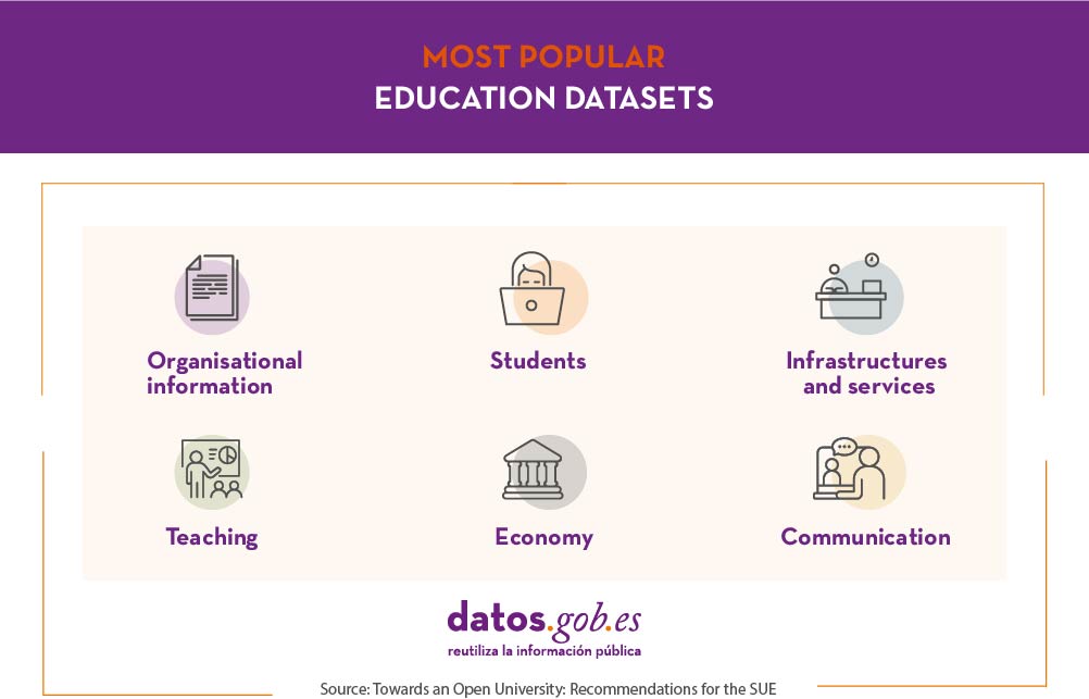
Below are some examples of data included in these categories:
- Organizational information: organization charts, profiles and personnel directories, job offers.
- Teaching: study catalogues, calendars, mobility programmes, educational content catalogues.
- Students: profiles, scholarship programmes, academic performance (such as grades or dropout rates), satisfaction rates.
- Economy: accounts, budgets, tenders, grants and subsidies.
- Infrastructures and services: buildings, geospatial information, images of the buildings, accessibility information, equipment, catering, computer or library services.
- Communication: events, news related to the university.
These datasets are of interest to those responsible in different governments for evaluating educational results and making political decisions to promote improvements, but also to parents and students themselves who have to choose about their future.
Moreover, these data, like all data, are susceptible to cross-checking with others to generate greater knowledge. For example, geospatial, demographic or social data can be used to conduct analyses of schools based on population density, access to services, internet connectivity or other factors.
What kind of education-related data can I find in datos.gob.es?
In datos.gob.es there are currently more than 1,600 data sets related to the Education category. The most important publishers of this type of data are the Government of Aragon, the National Institute of Statistics, the University of Zaragoza and the Autonomous Community of the Basque Country.
Of all these datasets, we have compiled some examples of the most popular ones and the formats in which they are found.
At state level
- Red.es. Location and equipment of Education programmes. CSV, XLS, ODS.
- ICEX España. Search engine for courses, seminars and conferences related to Foreign Trade. XHTML.
- CIS. Young people and the education system. ASCII.
- CIS. Current issues: the conflict in education. ASCII.
- INE. Number of students and households with students by type of education Household Expenditure on Education Survey. CSV. XLSX, XLS, HTML, JSON, PC-Axis.
At regional level
- Basque Government. Early school leaving rate of men aged 18-24 by country. CSV, XLS.
- Government of Aragon. Compulsory education, E. Infant and E. Special. Scholarship holders by level of education, financial educational administration and province of the scholarship holder. PC-Axis.
- Community of Madrid. Language options in schools in the Community of Madrid. JSON, CSV.
- Region of Murcia. Evolution of the teaching staff in General Education Public schools. XLS, XML-APP.
At the local level
- Rivas-Vaciamadrid City Council. Adult education centres. CSV, JSON, SHP, KML
- Cartagena City Council. Current news from the Universidad Popular. CSV, HTML, RDF-XML.
- Madrid City Council. Study and reading rooms. CSV, XML-APP, JSON, HTML, RSS, RDF-XML
- Vitoria-Gasteiz City Council. News related to employment and training. XML-APP
- Santander City Council. Culture, Education and Youth News. CSV, RDF-Turtle, HTML, JSON, RDF-XML, Atom, XML-APP, RDF-N3, JSON-LD, RSS
Universities
- University of Castilla-La Mancha. Supply and demand for undergraduate studies. CSV, HTML.
- University of Zaragoza. Performance by subject and qualification. CSV, JSON, HTML, XML-APP.
- University of Extremadura. Academic performance indicators 2020. CSV, XLS, JSON, RDF-Turtle, SPARQL.
In the case of university data, it is worth highlighting the UniversiDATA initiative, a collaborative project oriented and driven by public universities that seeks to promote open data in the higher education sector in Spain in a harmonised way.
In datos.gob.es we also have examples of applications and services that have been made through the reuse of this type of data, such as the Academic Application of the University of Extremadura or Ubicole, which offers the user the possibility of finding educational centres depending on the location and travel time. The European Data Portal also highlights several examples of open data and use cases related to the field of education on its website.
From datos.gob.es we invite you to visit our data catalogue and dive into all the datasets, as well as to devise new solutions based on them.
Noticia
At the end of 2018, Renfe launched its open data portal, a space to share information and key indicators with citizens. The launch of this portal was part of its digital transformation strategy to, in its own words, "put the customer at the center of all its services".
With the continuous maintenance of this portal, the operator seeks to improve services and attention to users, as well as to promote transparency and accountability. But, as is always the case with open data, the aim is not only to make the data accessible to citizens, but also to encourage its dissemination and use. Renfe's open data federation with datos.gob.es and consequently also its federation with the European Data Portal enhance its visibility both nationally and internationally.
63 sets of data on rail transport
Renfe currently has 63 datasets, which provide information on stations, schedules and notices in 6 formats, as shown in the image below.
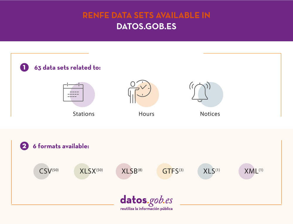
Since its inception, the portal has focused on providing operational data, such as general and suburban timetables, geolocated stations or notices of service changes. All of this, giving priority to machine-readable formats to facilitate their reuse.
Of all the datasets currently available, the most visited, according to their own control panel, are:
- High-speed, long-distance and medium-distance schedules.
- Local timetables.
- Stations. Complete list.
- Number of employees.
- List of High Speed, Long Distance and Medium Distance stations.
Renfe's idea is to continue expanding the datasets on a regular basis and taking into account the contributions of citizens. For example, on April 1 of this year they incorporated new data on Cercanías passengers by time slots, as well as train sheets.
Why are open transport data important?
Open data actions such as Renfe's help democratize information, so that it can be consumed free of charge and reused to create valuable products and services.
Transport data is one of the most reused data categories, which is why the European Commission (EC) has identified it as high-value data. In the datos.gob.es data applications section, you can find multiple examples of products and services that are based on this type of information.
The most popular applications created on the basis of this type of data are those that provide information on the arrival time and routes of the various trains or that integrate different transport methods to determine the easiest and quickest way to reach a destination, such as this example. But transport data also provide us with information to better understand our environment and make decisions. For example, we can know how the empty Spain moves, an important information for the development of policies to help us fight this problem. Or know the services of a particular metropolitan area, something fundamental when deciding where to buy a house.
These examples highlight the importance of transport data and why it is necessary to promote its openness and reuse. With the launch of its portal and its continuous updating, Renfe subscribes to its commitment to this type of data, and is aligned with the strategy set out by the European Union in its new directive, which highlights the need to open up transport data due to its great benefits for society, the environment and the economy.
Noticia
In the last few months we have spent so much time at home, and we have realized the importance of culture. Music, movies, reading or painting have made those hours spent at home much more bearable.
Cultural institutions have a lot of valuable information. This information includes the collections managed by cultural institutions, i.e. works that have been digitally shared free of charge by museums or libraries. But it also includes the knowledge available about those collections. All this material, if shared in open format, can be reused to develop, for example, educational and learning content, documentaries or animations.
What types of cultural data can I find in datos.gob.es?
At datos.gob.es we have an extensive catalogue of cultural data. There are currently 2,300 datasets that have been grouped under a category called "culture and leisure". Among these datasets we find state, regional and local information. The publishers that share the most data of this type are the Autonomous Community of the Basque Country, the Centre for Sociological Research, the National Institute of Statistics and the National Library of Spain.
Of these datasets, some of the most popular are:

You can access these datasets through the following links:
- Spanish authors in the public domain
- Archive of the Spanish website: thematic collection: feminism
- Cultural Parks of Aragon
- Agenda of the museums in the province of Barcelona
- Free activities in Madrid's Municipal Libraries
As we can see, most of these datasets are related to the literary field, one of the most prolific and advanced when it comes to opening its data. However, in the catalogue we can also find data related to the pictorial, cinematographic or musical field.
One advantage of cultural datasets is their cross-sectional nature. For example, datasets such as the thematic collection on feminism or those on immigration provide us with information on our society, something important for understanding how we were and are.
From datos.gob.es we invite you to visit our data catalogue and dive into all the datasets.
Noticia
We live in a connected world, where we all carry a mobile device that allows us to capture our environment and share it with whoever we want through social networks or different tools. This allows us to maintain contact with our loved ones even if we are thousands of kilometers away, but ... What if we also take advantage of this circumstance to enrich scientific research? We would be talking about what is known as citizen science.
Citizen science seeks "general public engagement in scientific research activities when citizens actively contribute to science either with their intellectual effort or surrounding knowledge or with their tools and resources". This definition is taken from the Green Paper on Citizen Science, developed in the framework of the European project Socientize (FP7), and explain us some of the keys to citizen science. In particular, citizen science is:
- Participatory: Citizens of all types can collaborate in different ways, through the collection of information, or by making their experience and knowledge available to the research. This mixture of profiles creates a perfect atmosphere for innovation and new discoveries.
- Volunteer: Given that participation is often altruistic, citizen science projects need to be aligned with the demands and interests of society. For this reason, projects that awaken the social conscience of citizens (for example, those related to environmentalism) are common.
- Efficient: Thanks to the technological advances that we mentioned at the beginning, samples of the environment can be captured with greater ubiquity and immediacy. In addition, it facilitates the interconnection, and with it the cooperation, of companies, researchers and civil society. All this generate cost reduction and agile results.
- Open: The data, metadata and publications generated during the investigation are published in open and accessible formats. This fact makes information easier to reuse and facilitate the repetition of research investigations to ensure its accuracy and soundness.
In short, this type of initiative seeks to generate a more democratic science that responds to the interests of all those involved, but above all, responds to the interest of citizens. And that generates information that can be reused in favour of society. Let's see some examples:
- Mosquito Alert: This project seeks to fight against the tiger mosquito and the yellow fever mosquito, species that transmit diseases such as Zika, Dengue or Chikungunya. In this case, citizen participation consists in sending photographs of insects observed in the environment that are likely to belong to these species. A team of professionals analyzes the images to validate the findings. The data generated allows to monitor and make predictions about their behavior, which helps control their expansion. All this information is shared openly through GBIF España.
- Sponsor a rock: With the objective of favoring the conservation of the Spanish geological heritage, the participants in this project commit to visit, at least once a year, the place of geological interest that they have sponsored. They will have to warn of any action or threat that they observe (anomalies, aggressions, pillaging of minerals or fossils ...). The information will help enrich the Spanish Inventory of Places of Geological Interest.
- RitmeNatura.cat: The project consists of following the seasonal changes in plants and animals: when flowering is, the appearance of new insects, the changes in bird migration ... The objective is to control the effects of the climate change. The results can be downloaded in this link.
- Identification of near-Earth asteroids: Participants in the project will help identify asteroids using astronomical images. The Minor Planet Center (organism of the International Astronomical Union responsible for the minor bodies of the Solar System) will evaluate the data to improve the orbits of these objects and estimate more accurately the probability of a possible impact with the Earth. You can see some of the results here.
- Arturo: An area where citizen science can bring great advantages is in the training of artificial intelligences. This is the case of Arturo, an automatic learning algorithm designed to determine which the most optimal urban conditions are. To do this, collaborators must answer a questionnaire where they will choose the images that best fit their concept of a habitable environment. The objective is to help technicians and administrations to generate environments aligned with the needs of citizens. The data generated and the model used can be downloaded at the following link.
If you are interested in knowing more projects of this type, you can visit the Spanish Citizen Science webpage whose objective is to increase knowledge and vision about citizen science. It includes the Ministry of Science, Innovation and Universities, the Spanish Foundation for Science and Technology and the Ibercivis Foundation. A quick look at the projects section will let you know what kind of activities are being carried out. Maybe you find one of your interest...