Application
Metrominuto is an application that provides its users with information on distances and times between the most important points of Pontevedra. It does this through a synoptic map, imitating the design of subway maps, installed in the city signage and also consultable through a mobile application. Among the app's functions, the following stand out:
- Provides information on the distance, time and calories needed to reach a place in the city from the starting point according to the user's location.
- Includes expanded information on points of interest on the map.
- Proposes itineraries according to categories such as hiking, bicycle route, special routes, etc.
- Allows to classify places as favorites.
- It offers the user the possibility of pointing out mobility problems on the route.
Metrominuto operates in the city of Pontevedra and uses information from its open data portal.
Blog
The National Centre for Geographic Information publishes open geospatial data from the National Cartographic System, the National Geographic Institute and other organisations through web applications and mobile applications to facilitate access to and consultation of geographic data by citizens.
Geospatial data is published via web services and APIs for reuse, so in the case of high-value datasets, it can be used in a variety of ways high-value datasets such as geographic names, hydrography or addresses as required by the as required by the EUthe EU has already made these datasets available to the public by June 2024 as they are associated with major benefits for society, the environment and the economy.
But in the applications listed below, the geographic data are visualised and consulted through web services, so that for downloading the data, it is possible to use web services and APIs directly, through a platform accessible to any user with a wide range of geographic information, ranging from topographic maps to satellite images.
But not only data can be reused, also application software is reusable, for example, the Solar Energy Potential of Buildings visualiser which is based on a visualiser API, named API-CNIG and allows the same tool to be used for different thematic areas.
Some examples of applications are:

Solar Energy Potential of Buildings
Provides the photovoltaic capacity of a building according to its location and characteristics. It also provides the average over the year and a point grid to identify the best location for solar panels.
National Geographic Gazetteer
It is a toponym search engine that collects the names, official or standardised by the corresponding competent bodies , with geographical references.
Unified postal address calculator
It is a converter that allows to know the geographical coordinates (latitude and longitude in WGS84) of the postal addresses of a place, and vice versa. In both cases, the input file is a CSV file, supporting both coordinates and postal addresses.
Basic Maps of Spain
It facilitates connection to IGN services and to the CNIG download centre to obtain maps and routes. With this mobile application you can follow the routes of the National Parks or the stages of the Camino de Santiago. It allows you to plan excursions using maps, navigate and take guided tours, without the need for an internet connection after downloading data.
Map a la carte
It allows you to create a customised map using the printed series of the National Topographic Map at scales 1:25.000 and 1:50.000. It offers the possibility of defining its area, incorporating contents, personalising the cover, obtaining a pdf file and even acquiring paper copies by post.
IGN Earthquakes
It allows the reception and visualisation of all seismic events in Spain and its surroundings. It provides the distance to the epicentre of the seismic event and epicentral parameters, as well as the geolocation of the user's position and the epicentre.
Maps of Spain
It is a free mobile viewer ideal for hiking, cycling, running, skiing, etc., which uses as background cartography the services of the National Geographic Institute and another set of services from other Ministries, such as the Cadastral information of the plots provided by the General Directorate of Cadastre.
Camino de Santiago
It includes information of a cultural and practical nature on each of the stages (hostels, monuments, etc.), as well as a complete Pilgrim's Guide detailing what you should know before starting out on any of the routes. This application is based on ESRI software.
National Parks
Displays information on the history, fauna, flora and excursions in Spain's National Parks. It includes hundreds of points of interest such as information centres, accommodation, viewpoints, refuges and even routes through the parks, indicating their duration and difficulty. The app is available for download on Android e iOS. This application is based on ESRI software.
GeoSapiens IGN
It presents interactive maps, free to use and free of charge, to study the physical and political geography of Spain and the world. It consists of different games relating to the whole of Spain or by autonomous communities, the whole world and by continent.
In addition to the applications developed by the CNIG, which are also presented in this video this videothere are many other digital solutions developed by third parties that reuse open geospatial data to offer a service to society. For example, in the list of data reusing applications.gob.es you can find from a map that shows the fires that are active in Spain in real time in Spain in real time to an app that shows where the parking spaces for people with reduced mobility parking spaces for people with reduced mobility in each town.
In short, anyone can make use of the open geographic data of the National Cartographic System, the National Geographic Institute and other bodies published by the CNIG , thus extending the advantages offered by the availability of open geographic data. do you know of any other application resulting from the reuse of open data? You can send it to us at dinamizacion@datos.gob.es
Application
It is a website that reuses open data to report on how green spaces and trees are distributed in the city of Valencia.
The information on the website is divided into three areas:
- Valencia city
- Municipal area of Valencia
- Data on trees in Valencia city
The data shown on Valencia Verde comes from open data catalogs on green spaces and trees available at Ajuntament de València - Dades Obertes, census data from the Oficina d'Estadística de València and information from the Institut Cartogràfric Valencià.
The last date for obtaining the aforementioned data, and for updating this website, is March 2024.
Thanks to this information, visualizations are created in which users can see, for example, the percentage of green area per neighborhood/district and the m2 of green area per inhabitant in each neighborhood/district. This application is a space that allows to know, in a clear and interactive way, the trees, green areas and their relationship with the population and neighborhoods of Valencia.
Blog
After months of new developments, the pace of advances in artificial intelligence does not seem to be slowing down - quite the contrary. A few weeks ago, when reviewing the latest developments in this field on the occasion of the 2023 deadline, video generation from text instructions was considered to be still in its infancy. However, just a few weeks later, we have seen the announcement of SORA. With this tool, it seems that the possibility to generate realistic videos, up to one minute long, from textual descriptions is here.
Every day, the tools we have access to become more sophisticated and we are constantly amazed by their ability to perform tasks that once seemed exclusive to the human mind. We have quickly become accustomed to generating text and images from written instructions and have incorporated these tools into our daily lives to enhance and improve the way we do our jobs. With each new development, pushing the boundaries a little further than we imagined, the possibilities seem endless.
Advances in Artificial Intelligence, powered by open data and other technologies such as those associated with the Web3, are helping to rethink the future of virtually every field of our activity: from solutions to address the challenges of climate change, to artistic creation, be it music, literature or painting[6], to medical diagnosis, agriculture or the generation of trust to drive the creation of social and economic value.
In this article we will review the developments that impact on a field where, in the coming years, interesting advances are likely to be made thanks to the combination of artificial intelligence and open data. We are talking about the design and planning of smarter, more sustainable and liveable cities for all their inhabitants.
Urban Planning and Management
Urban planning and management is complicated because countless complex interactions need to be anticipated, analysed and resolved. Therefore, it is reasonable to expect major breakthroughs from the analysis of the data that cities increasingly open up on mobility, energy consumption, climatology and pollution, planning and land use, etc. New techniques and tools provided by generative artificial intelligence combined, for example, with intelligent agents will allow a deeper interpretation and simulation of urban dynamics.
In this sense, this new combination of technologies could be used for example to design more efficient, sustainable and liveable cities, anticipating the future needs of the population and dynamically adapting to changes in real time. Thus, new smart urban models would be used to optimise everything from traffic flow to resource allocation by simulating behaviour through intelligent agents.

Figure 1: Images generated by Urbanistai.com
Urbanist.ai is one of the first examples of an advanced urban analytics platform, based on generative artificial intelligence, that aims to transform the way urban planning tasks are currently conceived. The services it currently provides already allow the participatory transformation of urban spaces from images, but its ambition goes further and it plans to incorporate new techniques that redefine the way cities are planned. There is even a version of UrbanistAI designed to introduce children to the world of urban planning.
Going one step further, the generation of 3D city models is something that tools such as InfiniCity have already made available to users. Although there are still many challenges to be overcome, the results are promising. These technologies could make it substantially cheaper to generate digital twins on which to run simulations that anticipate problems before they are built.
Available data
However, as with other developments based on Generative AI, these issues would not be possible without data, and especially not without open data. All new developments in AI use a combination of private and public data in their training, but in few cases is the training dataset known with certainty, as it is not made public. Data can come from a wide variety of sources, such as IoT sensors, government records or public transport systems, and is the basis for providing a holistic view of how cities function holistic view of how cities function and how and how their inhabitants interact with the urban environment.
The growing importance of open data in training these models is reflected in initiatives such as the Task Force on AI Data Assets and Open Government, launched by the US Department of Commerce, which will be tasked with preparing open public data for Artificial Intelligence. This means not only machine-readable formats, but also machine-understandable metadata. With open data enriched by metadata and organised in interpretable formats, artificial intelligence models could yield much more accurate results.
A long-established and basic data source is OpenStreetmap (OSM), a collaborative project that makes a free and editable map of open global geographic dataavailable to the community. It includes detailed information on streets, squares, parks, buildings, etc. which is crucial as a basis for urban mobility analysis, transport planning or infrastructure management. The immense cost of developing such a resource is only within the reach of large technology companies, making it invaluable to all initiatives that use it as a basis.

Figure 2: OpenStreetmap Images (OSM)
More specific datasets such as HoliCity, a 3D data asset with rich structural information, including 6,300 real-world views, are proving valuable. For example, recent scientific work based on this dataset has shown that it is possible for a model fed with millions of street images to predict neighbourhood characteristics, such as home values or crime rates.
Along these lines, Microsoft has released an extensive collection of building contours automatically generated from satellite imagery, covering a large number of countries and regions.

Figure 3: Urban Atlas Images (OSM)
Microsoft Building Footprints provide a detailed basis for 3D city modelling, urban density analysis, infrastructure planning and natural hazard management, giving an accurate picture of the physical structure of cities.
We also have Urban Atlas, an initiative that provides free and open access to detailed land use and land cover information for more than 788 Functional Urban Areas in Europe. It is part of the Copernicus Land Monitoring Serviceprogramme, and provides valuable insights into the spatial distribution of urban features, including residential, commercial, industrial, green areas and water bodies, street tree maps, building block height measurements, and even population estimates.
Risks and ethical considerations
However, we must not lose sight of the risks posed, as in other domains, by the incorporation of artificial intelligence into the planning and management of cities, as discussed in the UN report on "Risks, Applications and Governance of AI for Cities". For example, concerns about privacy and security of personal information raised by mass data collection, or the risk of algorithmic biases that may deepen existing inequalities. It is therefore essential to ensure that data collection and use is conducted in an ethical and transparent manner, with a focus on equity and inclusion.
This is why, as city design moves towards the adoption of artificial intelligence, dialogue and collaboration between technologists, urban planners, policy makers and society at large will be key to ensuring that smart city development aligns with the values of sustainability, equity and inclusion. Only in this way can we ensure that the cities of the future
are not only more efficient and technologically advanced, but also more humane and welcoming for all their inhabitants.
Content prepared by Jose Luis Marín, Senior Consultant in Data, Strategy, Innovation & Digitalization. The contents and views reflected in this publication are the sole responsibility of the author.
Application
The application shows all public wireless networks in the city of Valencia and allows its geolocation. It offers a map to identify the location of the network and a free text field to insert any comment. It also has a detailed screen with which the user can rate from 1 to 5 the quality of the installation and the signal.
All this is stored on the device so that nothing is lost when closing the application.
The application is available in English, Spanish, Chinese and Japanese.
Application
This free software application offers a map with all the trees in the city of Barcelona geolocated by GPS. The user can access in-depth information on the subject. For example, the program identifies the number of trees in each street, their condition and even the species.
The application's developer, Pedro López Cabanillas, has used datasets from Barcelona's open data portal (Open Data Barcelona) and states, in his blog, that it can be useful for botany students or "curious users". The Barcelona Trees application is now in its third beta version.
The program uses the framework Qt, C++ and QML languages, and can be built (using a suitable modern compiler) for the most common targets: Windows, macOS, Linux and Android operating systems.
Noticia
After months of work, the second edition of the Barcelona Dades Obertes Challenge has come to end. Leading by the City Council of Barcelona and with the collaboration of the Consorci d'Educació de Barcelona and CESIRE, the project seeks to promote the knowledge and use of open data in schools in the city.
The final act took place on May 8 at the Fábrica de Creació de Fabra i Coats. In front of more than 300 attendees, Laia Servera, journalist and director of InfoK - the news program of Super3, the children's channel of Catalonian Television - acted as master of ceremonies. The event was also attended by Màrius Boada i Pla, Director of the Municipal Office of Dades, responsible for opening and closing the session, and national and international experts through video-conference: Martin Alvarez Espinar, director in Spain of the World Wide Web Consortium (W3C), Antje Kirchner, Survey Methodologist and head of the BigSurv18 congress, Esther Huyer, representative of the European Data Portal, and Taisuke Matsuzaki, representative of the Kobe City Council who commented on the experience of the World Data Viz Challenge 2018 Barcelona-Kobe .
During the event, the students of the 8 finalist centres had the opportunity to present and defend their work. After the jury deliberation, the prizes were awarded as follows:
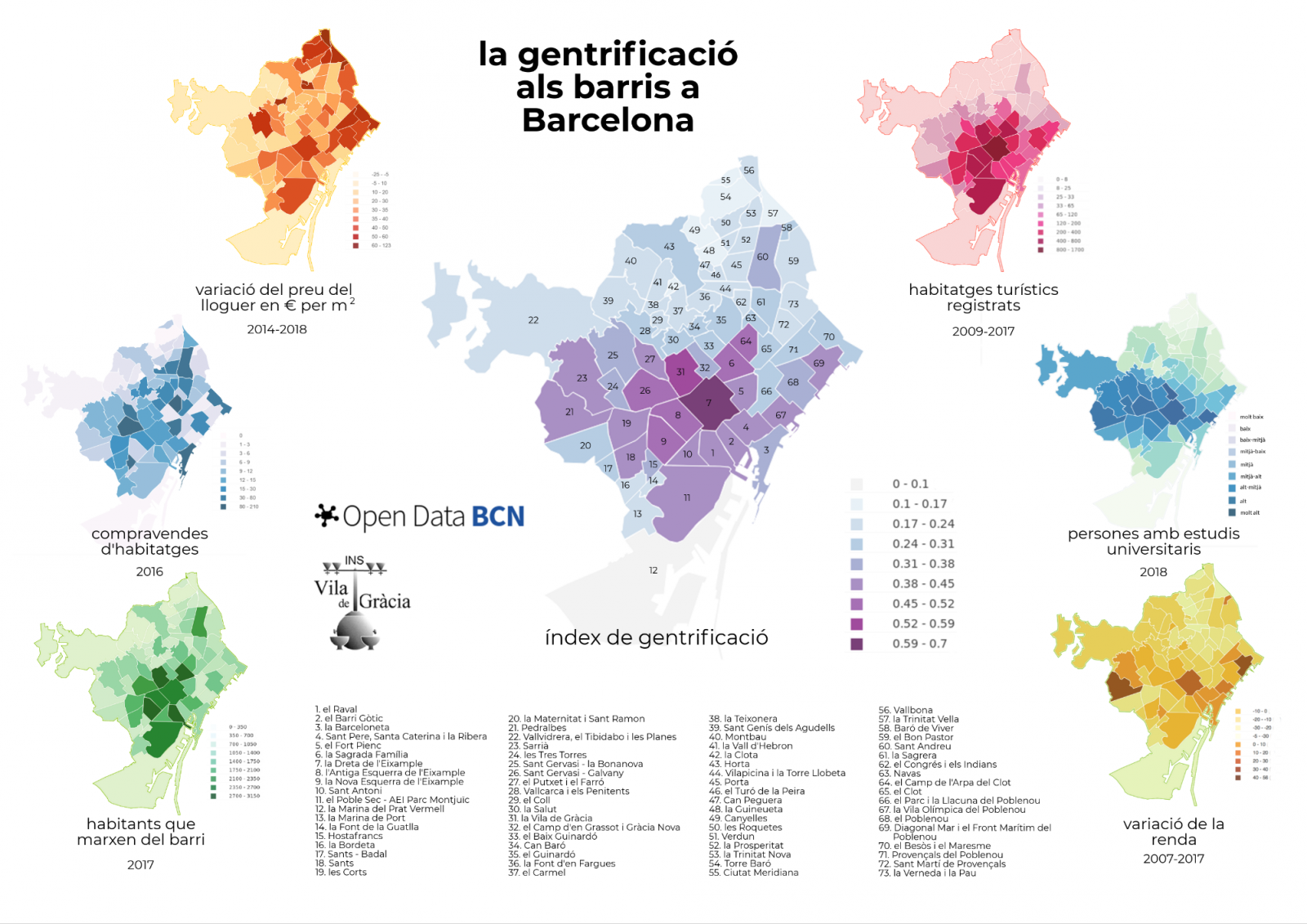
- The first prize went to the Institut Vila de Gràcia in Barcelona, with the project "La gentrificació als barris a Barcelona" (Gentrification in Barcelona neighbourhoods). The objective of the project was to show the process of urban transformation caused by strategic speculative actions that cause the displacement of the original population from one neighbourhood to another. To do this, the students developed a gentrification index, using datasets such as Number of inhabitants that leave their neighbourhoods, Purchase in relation to total housing or Rent variation in € / m2.
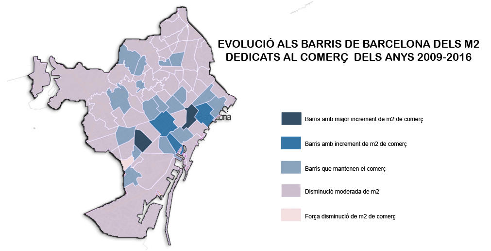
- The second prize went to the Institut Lluïsa Cura with "Evolució del comerç als barris de Barcelona" (Commerce evolution in Barcelona neighbourhoods). With this projects, the students wanted to confirm that traditional commerce was losing market share due to international brand stores and new forms of small convenience stores. For this, they used data related to the surface of the cadastral premises in Barcelona city.
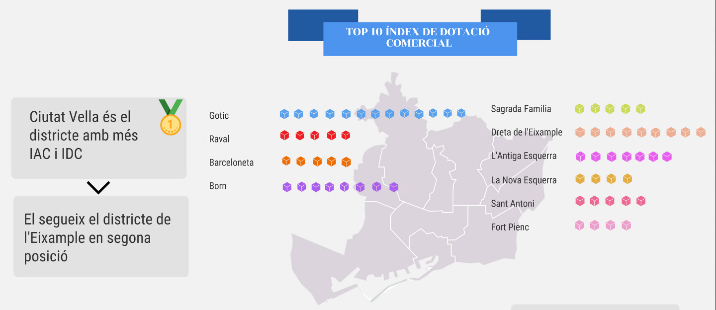
- The third prize went to the Institut Joan Brossa and his "On locate the meva botiga to Barcelona?" (Where to locate my store in Barcelona?). The analysis was based on the comparison of the Commercial Endowment Index and the Commercial Attraction Index.
Highlight the great effort that teachers and students have made one more year to create very interesting projects. You can learn more about the winning projects and the rest of the finalist projects here.
Congratulations to the winners and all the participants! Now we only have to wait for the third edition 2020, which will surely be also a success.
Noticia
Following initial contacts with Open Data and Smart Cities, the attendees at the International Open Data Conference enjoyed a second session dedicated to Open Data and Cities, moderated by Stephen Larrick from Sunlight Foundation, which gathered two experts from government bodies and two members of civil society to continue with the presentation of success cases worldwide.
It is estimated that 80% of Latin American population will live in cities in 2050. This demographic flow will arise new challenges in transport, education, waste management o housing, priority areas where open data can be a tool and response to those problems in future. The Inter-American Development Bank operates in this context, its representative Antonio Moneo was responsible for starting this panel describing the work of the IADB in the promotion of open data as the solution for current challenges in cities.
Within the different programs, the IADB helps and teaches towns in Latin America the potential of open data to face public problems and their possible impact to improve the life quality in urban areas. Thus, the Bank has helped Argentinian cities in their urbanistic planning, villages in Ecuador to manage natural disasters or Rio Janeiro in Brazil with the Zika epidemic. After all, according to Moneo’s words, in any process of information openness, the data are not the most important aspect, but the collaboration arose during the process to respond to specific necessities.
In the same continent, Eric Resee presented the project developed by the independent organization Bloomberg Philantrophics “What works cities: building capacity for open data in mid-sized cities”. An initiative within the Govex project which works with a network of 39 north american cities that lack of the necessary tools to re-use the open data in an efficient way. The entity helps those towns create sustainable open data programs that promote transparency and citizen participation. In this way, local governments would be able to incorporate data in their decision making to improve the operations in the city.
After his speech, it was local government representatives’ turn. Víctor Moran, from Zaragoza City Council, explained how the city’s open data portal works from the technical point of view and, lastly, Zira Rivera, coordinador of Smart-Dublin, showed the local initiative Dublinked, whose goal is promoting the development of innovative solutions based on open data, using the city as a test bed. Concurrently, this program plays two important roles: on one hand, it is an open data repository, published last march, with more than 300 datasets available for their re-use. And it is also a network that organizes regular events and activities to create an ecosystem for big and small companies, researches, public bodies and citizens interested in data.
In this regard, Zaira Rivera showed several projects such as DublinDashboard that provides visualizations based on open data from different sources or the funding program developed by the County Council to find solutions to road safety problems in the city, based on local open data.
After their speeches, an interesting discussion started where attendees had the opportunity to share their doubts with the experts. The global challenge that any Smart Cities addresses was highlighted: opening and bringing the accurate information for the specific needs of the citizen. Moreover, different methods to measure the impact of open data policies were analyzed showing how each project uses different performance indicators to assess its success.
In short, idea and knowledge sharing, real cases and, above all, commitment to build more intelligent and effective urban areas were the joint points of the community gathered at this session in the International Conference which, in its last edition, showed the good health of the Smart City and Open Data sector in the world.
Noticia
Every day the need of information increases in urban areas. The cities are becoming sophisticated ecosystems that, using the technological advances, are able to respond to the demands which arise in sectors so diverse as transport, health, education, waste management or infraestructures. In this context, open data can help us understand and interact in a more sustainable and effective way with cities. The openness and re-use of local public information lets us know in real time the bus schedules, localize the nearest retail business or identify the best neighborhood to buy a house. The development of Smart Cities cannot be understood nowadays without open data.
On the occasion of the last International Open Data Conference, Madrid was the setting of different events that, along the week, analyzed the impact of open data in the cities. Within the program of activities previous to IODC, the Open Data Summit gathered the open data community in the Madrid’s exhibition centre Media-lab Prado in order to find solutions to the challenges of the Smart Cities related to open data policies, urbanism, environment and competitivity.
The Conference itself dedicated several sessions exclusively to this area such as the panel A global marketplace for city data or the meeting about the OjoalData100 initiative to harmonize datasets in Smart Cities. Concurrently, IODC organized two tables in the first day to show success cases around the world which prove the perfect couple formed by open data and smart cities. A large group of national and international experts showed the attendees projects aimed at promoting Smart Cities through open data.
Sergio Fdez Balaguer from Empresa Municipal de Transportes of Madrid was in charge of starting the first session, moderated by Jean-Noé Landry, executive director of Open Northe- Canadian Open Government Partnership Civil Society Network. With approximately 1.5 million passengers per day and more than 85 million kilometres driven per year, this public entity has its own open data portal since 2011; platform that, nowadays, has 800 developers registered and receives each month 35 million hits with data requests. Thanks to the change of mind and the commitment to information openness of EMT, till 40 official apps have been created by third parties. The expert also talked about the project Mobility Labs Madrid, an open and interoperable platform where users can publish and re-use data, promoting the information sharing between the citizens and the local body.
The British initiative MediaMill, presented by Andy Dickinson, also showed the potential of open data in the cities. Despite of UK is one of the open data leaders in the world, only 4% of the 18.000 datasets from the national catalogue belong to local governments. The goal of MediaMill project is promoting the development of open source and open data platforms in two specific regions in England: Leeds and York. This program identifies ways that local data can be transformed into media stories and visualizations that help citizens understand the environment in which they live, improving their quality of live and active participation.
The second international practice case comes from Asia. The success case, Jakarta Smart City shown by Sinitra A. Punti proved how that platform uses the Information Technologies to empower the citizen, who re-uses and produces urban data, track the government activities and improve the public services in the city.
Lastly, Daniel Sarasa, responsible for Smart City division at Zaragoza City Council, explained to those present the role played by the Aragon’s capital in the international project CITYKeys, whose aim is creating a methodology to assess and compare the Smart Cities policies in Europe. Sarasa took this opportunity to highlight the importance of maximising the local community talent to develop the Smart Cities through the citizen collaboration and the organization of events -such as hackathons- that gather the different stakeholders looking for innovative solutions based on open data.
All the examples shown in this session at IODC were just a small sampling of the potential offered by the binomial: open data and Smart Cities. Thanks to open data, it is possible to establish mechanisms of transparency and citizen participation, improving the interoperability between the public administrations and the society, and, increasing, as a result, the access to public sector information and the intelligence in the cities.
Noticia
CartoCrítica is an independent civil initiative, a non-profit organization that works for transparency and free access to public information in Mexico, applying geospatial technology, re-using national open data and cartographic analysis to defend the national territory, the human rights and the environment.
Thus, the platform offers different maps and visualizations segmented into seven categories - environment, water, hydrocarbons, mining, indigenous peoples and health- where users can know the current situation in these areas and, through the data that the initiative collects and treats, understand what is happening in their country.
So, thanks to CartoCrítica in collaboration with the Mexican Alliance Against Fracking, the citizens were informed that nearly a thousand oil wells use the fracking process to extract oil or natural gas in Mexico. In this way, the entity alerted that those perforations were made without any consultation or consent of the affected communities, as it is stipulated in Article 120 of the Mexican Law of Hydrocarbons that obliges those entities to inform the affected population about such projects.
Other examples of the benefits of the openness and re-use of open data are the recent visualizations of Cartocrítica on the water concession to the mining industry in the country; a sector where it is very difficult to find public, accessible and detailed information. In order to know the impact of mining activities in the Mexican environment and its water consumption, a comprehensive information search was performed to create maps and data tables to show the project conclusions.
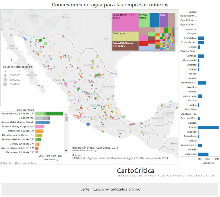
So, thanks to the work of the entity, we know that mining industry in Mexico has been granted the same volume of water that twelve million people would need in a year; in a country where there are still 13.8 million people with no access to water in their homes.
Thanks to initiatives like Cartocrítica which makes available public sector information that is hidden and transform it into knowledge, citizens can be better informed and participate in the processes that affect their context. Therefore, the further collaboration with both public and private entities is needed to promote the openness of data that remain inaccessible. Only in this way projects as Cartocrítica can reuse them for the common good, revealing and focussing on those bad practices and abuses that occur in the different socio-economic sectors