Blog
Housing is one of the main concerns of Spanish citizens, according to the January 2025 barometer of the Centro de Investigaciones Sociológicas (CIS). In order to know the real situation of access to housing, it is necessary to have public, updated and quality data, which allows all the actors in this ecosystem to carry out analyses and make informed decisions.
In this article we will review some examples of available open data, as well as tools and solutions that have been created based on them to bring this information closer to citizens.
Examples of housing data Open data can have several uses in this sector:
- Enable public bodies to understand citizens' needs and develop policies accordingly.
- Helping individuals to find homes to rent or buy.
- Providing information to builders and companies so that they can develop housing that responds to these needs.
Therefore, in this field, the most used data include those referring to housing, but also to demographic and social aspects, often with a high geospatial component. Some of the most popular datasets in this sense are the Housing and Consumer Price Indexes of the National Statistics Institute (INE) or the Cadastre data.
Different public bodies have made available to the public spaces where they gather various data related to housing. This is the case of Barcelona City Council and its portal "Housing in data", an environment that centralises access to information and data from various sources, including datasets from its open data portal.
Another example is the Madrid City Council data visualisation portal, which includes dashboards with information on the number of residential properties by district or neighbourhood, as well as their cadastral value, with direct access to download the data used.
Further examples of bodies that also provide access to this type of information are the Junta de Castilla y León, the Basque Government or the Comunidad Valenciana. In addition, those who wish to do so can find a multitude of data related to housing in the National Catalogue of Open Data, hosted here, at datos.gob.es.
It should also be noted that it is not only public bodies that open data related to this subject. A few months ago, the real estate portalidealistareleased a dataset with detailed information on thousands of properties in Madrid, Barcelona and Valencia. It is available as a package in R via Github.
Tools and solutions to bring this data closer to citizens
Data such as the above can be reused for multiple purposes, as we showed in previous articles and as we can see in this new approach to the various use cases:
Data journalism
The media use open housing data to provide a more accurate picture of the housing market situation, helping citizens understand the dynamics affecting prices, supply and demand. By accessing data on price developments, housing availability or related public policies, the media can generate reports and infographics that explain in an accessible way the situation and how these factors impact on people's daily lives. These articles provide citizens with relevant information, in a simple way, to make decisions about their housing situation.
One example is this article which allows us to visualise, neighbourhood by neighbourhood, the price of rent and access to housing according to income, for which open data from the Ministry of Housing and Urban Agenda, the Cadastre and the INE, among others, were used. Along the same lines is this article on the percentage of income to be spent on rent.
Reporting and policy development
Open data on housing is used by public bodies such as the Ministry of Housing and Urban Agenda in its Housing and Land Observatory, where electronic statistical bulletins are generated that integrate data available from the main official statistical sources. The aim is to monitor the sector from different perspectives and throughout the different phases of the process (land market, built products, accessibility and financing, etc.). The Ministry of Housing and Urban Agenda also uses data from various sources, such as the Tax Agency, the Cadastre or the INE, for its State Reference System of Housing Rental Prices, which defines ranges of rental price values for housing in areas declared as stressed.
Offer of real estate services
Open data can be valuable for the construction sector: open information on land use and permits is consulted before excavation work is undertaken and new construction starts.
In addition, some of the companies using open data are real estate websites. These portals reuse open data sets to provide users with comparable property prices, neighbourhood crime statistics or proximity to public educational, health and recreational facilities. This is helped, for example, by tools such as Location intelligence, which provides access to census data, rental prices, housing characteristics or urban planning. Public bodies can also help in this field with their own solutions, such as Donde Vivo, from the Government of Aragon, which allows you to obtain an interactive map and related information of the nearest points of interest, educational and health centres as well as geostatistical information of the place where you live.
There are also tools that help to forecast future costs, such as Urban3r, where users can visualise different indicators that help them to know the energy demand data of residential buildings in their current state and after undergoing energy refurbishment, as well as the estimated costs of these interventions.This is a field where data-driven disruptive technologies, such as artificial intelligence, will play an increasingly important role, optimising processes and facilitating decision-making for both home buyers and suppliers. By analysing large volumes of data, AI can predict market trends, identify areas of high demand or provide personalised recommendations based on the needs of each user. Some companies have already launched chatbots, which answer users' questions, but AI can even help create projects for the development of affordable and sustainable housing.
In short, we are in a field where new technologies are going to make it easier and easier for citizens to find out about the supply of housing, but this supply must be aligned with the needs of users. It is therefore necessary to continue promoting the opening up of quality data, which will help to understand the situation and promote public policies and solutions that facilitate access to housing.
Blog
After months of new developments, the pace of advances in artificial intelligence does not seem to be slowing down - quite the contrary. A few weeks ago, when reviewing the latest developments in this field on the occasion of the 2023 deadline, video generation from text instructions was considered to be still in its infancy. However, just a few weeks later, we have seen the announcement of SORA. With this tool, it seems that the possibility to generate realistic videos, up to one minute long, from textual descriptions is here.
Every day, the tools we have access to become more sophisticated and we are constantly amazed by their ability to perform tasks that once seemed exclusive to the human mind. We have quickly become accustomed to generating text and images from written instructions and have incorporated these tools into our daily lives to enhance and improve the way we do our jobs. With each new development, pushing the boundaries a little further than we imagined, the possibilities seem endless.
Advances in Artificial Intelligence, powered by open data and other technologies such as those associated with the Web3, are helping to rethink the future of virtually every field of our activity: from solutions to address the challenges of climate change, to artistic creation, be it music, literature or painting[6], to medical diagnosis, agriculture or the generation of trust to drive the creation of social and economic value.
In this article we will review the developments that impact on a field where, in the coming years, interesting advances are likely to be made thanks to the combination of artificial intelligence and open data. We are talking about the design and planning of smarter, more sustainable and liveable cities for all their inhabitants.
Urban Planning and Management
Urban planning and management is complicated because countless complex interactions need to be anticipated, analysed and resolved. Therefore, it is reasonable to expect major breakthroughs from the analysis of the data that cities increasingly open up on mobility, energy consumption, climatology and pollution, planning and land use, etc. New techniques and tools provided by generative artificial intelligence combined, for example, with intelligent agents will allow a deeper interpretation and simulation of urban dynamics.
In this sense, this new combination of technologies could be used for example to design more efficient, sustainable and liveable cities, anticipating the future needs of the population and dynamically adapting to changes in real time. Thus, new smart urban models would be used to optimise everything from traffic flow to resource allocation by simulating behaviour through intelligent agents.

Figure 1: Images generated by Urbanistai.com
Urbanist.ai is one of the first examples of an advanced urban analytics platform, based on generative artificial intelligence, that aims to transform the way urban planning tasks are currently conceived. The services it currently provides already allow the participatory transformation of urban spaces from images, but its ambition goes further and it plans to incorporate new techniques that redefine the way cities are planned. There is even a version of UrbanistAI designed to introduce children to the world of urban planning.
Going one step further, the generation of 3D city models is something that tools such as InfiniCity have already made available to users. Although there are still many challenges to be overcome, the results are promising. These technologies could make it substantially cheaper to generate digital twins on which to run simulations that anticipate problems before they are built.
Available data
However, as with other developments based on Generative AI, these issues would not be possible without data, and especially not without open data. All new developments in AI use a combination of private and public data in their training, but in few cases is the training dataset known with certainty, as it is not made public. Data can come from a wide variety of sources, such as IoT sensors, government records or public transport systems, and is the basis for providing a holistic view of how cities function holistic view of how cities function and how and how their inhabitants interact with the urban environment.
The growing importance of open data in training these models is reflected in initiatives such as the Task Force on AI Data Assets and Open Government, launched by the US Department of Commerce, which will be tasked with preparing open public data for Artificial Intelligence. This means not only machine-readable formats, but also machine-understandable metadata. With open data enriched by metadata and organised in interpretable formats, artificial intelligence models could yield much more accurate results.
A long-established and basic data source is OpenStreetmap (OSM), a collaborative project that makes a free and editable map of open global geographic dataavailable to the community. It includes detailed information on streets, squares, parks, buildings, etc. which is crucial as a basis for urban mobility analysis, transport planning or infrastructure management. The immense cost of developing such a resource is only within the reach of large technology companies, making it invaluable to all initiatives that use it as a basis.

Figure 2: OpenStreetmap Images (OSM)
More specific datasets such as HoliCity, a 3D data asset with rich structural information, including 6,300 real-world views, are proving valuable. For example, recent scientific work based on this dataset has shown that it is possible for a model fed with millions of street images to predict neighbourhood characteristics, such as home values or crime rates.
Along these lines, Microsoft has released an extensive collection of building contours automatically generated from satellite imagery, covering a large number of countries and regions.

Figure 3: Urban Atlas Images (OSM)
Microsoft Building Footprints provide a detailed basis for 3D city modelling, urban density analysis, infrastructure planning and natural hazard management, giving an accurate picture of the physical structure of cities.
We also have Urban Atlas, an initiative that provides free and open access to detailed land use and land cover information for more than 788 Functional Urban Areas in Europe. It is part of the Copernicus Land Monitoring Serviceprogramme, and provides valuable insights into the spatial distribution of urban features, including residential, commercial, industrial, green areas and water bodies, street tree maps, building block height measurements, and even population estimates.
Risks and ethical considerations
However, we must not lose sight of the risks posed, as in other domains, by the incorporation of artificial intelligence into the planning and management of cities, as discussed in the UN report on "Risks, Applications and Governance of AI for Cities". For example, concerns about privacy and security of personal information raised by mass data collection, or the risk of algorithmic biases that may deepen existing inequalities. It is therefore essential to ensure that data collection and use is conducted in an ethical and transparent manner, with a focus on equity and inclusion.
This is why, as city design moves towards the adoption of artificial intelligence, dialogue and collaboration between technologists, urban planners, policy makers and society at large will be key to ensuring that smart city development aligns with the values of sustainability, equity and inclusion. Only in this way can we ensure that the cities of the future
are not only more efficient and technologically advanced, but also more humane and welcoming for all their inhabitants.
Content prepared by Jose Luis Marín, Senior Consultant in Data, Strategy, Innovation & Digitalization. The contents and views reflected in this publication are the sole responsibility of the author.
Documentación
The Sustainable Development Goals (SDGs) are a set of targets adopted by the international community aimed at addressing the most pressing challenges of our time. These goals were born simultaneously with the Global Partnership for Sustainable Development Data and the International Open Data Charter, which provided a coalition of experts willing to harness the benefits of open data for the new development agenda.
In this regard, open data plays a very relevant role within the development agenda as indicators of progress towards the SDGs, as they allow measuring and evaluating their progress, as well as improving accountability through sharing that data with the rest of the community, providing great value in multiple ways:
- Facilitating decision-making when designing policies and strategies to help meet the objectives;
- Identifying inequalities and specific challenges among different regions or population groups;
- Improving efficiency in policy and program implementation;
- As an engine of innovation through research and development.
Today, there are large global databases, both generalist and thematic, that we can use for these purposes, in addition to all the national data sources available in our own country. However, there is still a long way to go in this regard: the proportion of SDG indicators that are conceptually clear and have good national coverage is still 66%, according to the latest SDG progress report published in 2023. This leads us to continue facing data gaps in vital areas such as poverty, hunger, education, equality, sustainability, climate, seas, and justice, among others. Additionally, there is also a fairly general and significant lack of data disaggregated by age and/or sex, making it very difficult to properly monitor the potential progress of the objectives regarding the most vulnerable population groups.
This report takes a journey through the dual role that open data plays in supporting national and global progress in achieving the SDGs. The first part of the report focuses on the better-known role of open data as mere indicators when measuring progress towards the objectives, while the second part addresses its role as a key tool and fundamental raw material for the development of society in general and for the achievement of the objectives themselves in particular. To this end, it explores which datasets could have the greatest potential in each case, showing some practical examples, both national and at the European level, in various specific development objectives.
If you want to learn more about the content of this report, you can watch the interview with its author.
Blog
Did you know that opening information in sectors such as housing can help you find your new home? Moving house is not usually an easy decision and some doubts may arise, such as whether it is more profitable to buy or rent, what services are available in each neighbourhood of the city or what is the approximate price of housing on the market.
The data provided by public bodies can help us find answers to these and many other questions. This data can be used to create tools and applications that, in a simple and user-friendly way, allow us to compare parameters and make better decisions, some of which we have already collected in a previous article. On this occasion we update the information including 10 new use cases, offered by public and private organisations, which can offer you information of interest to find your new home.
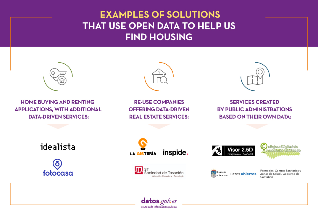
Home buying and renting applications offering additional data-driven services
There are currently numerous digital tools and applications that provide users with information about property listings for sale or rent. Some of these companies also offer additional services based on data that provide a better understanding of the market. Let's look at two examples.
- Idealista. In Idealista, users can find an analysis based on data from the real estate market in Spain, Portugal and Italy. To do so, they use data from both public sources (for example, from the Cadastre, the National Geographic Institute or the INE) and private sources from the idealista.com portal itself. It also has a set of technological tools - including the possibility of accessing the platform's data through an API - and information analysis tools to process, homogenise and structure useful data sources and transform them into easily accessible information. An example is the map of average sales price per square metre or its prediction of how much solar energy could be generated by all the municipalities in Spain.
- Fotocasa. This platform provides users with interactive maps with data from its Real Estate Index to know, in real time, the sale and rental price per m2 according to the supply of homes that are advertised on the real estate portal. Fotocasa encourages the use of open data, making it possible to use this valuable data to measure the market.
Re-use companies
In the market we also find companies specialised in data reuse, which exploit their potential to create services of interest in the real estate field. Some examples are:
- La Gistería. This consultancy company specialises in data visualisations using GIS technologies. Together with Geomarketing inmobiliario de Madrid, they have created 27 maps delimited by zones, positioning the points of interest in different areas such as health, leisure, or education. These maps have been created using the open data of the Madrid City Council and the brand identity of the real estate company Engel & Volkers in order to integrate it into their website and facilitate the search for a flat by users.
- Inspide. Through a web application, it allows to know if a city like Madrid adapts to the requirements of social distancing derived from the current pandemic situation and what urban actions could solve this problem. Inspide shows, for example, the width of the pavements represented with colours, and specifies whether their width is adequate to maintain the required distance between pedestrians. This is a very interesting application if we want to find a wide neighbourhood with wide streets in which to buy our next home.
- Sociedad de Tasación. This is an independent appraisal company that offers valuations of all types of assets, especially real estate assets. It offers valuation, consultancy and technological services, such as the use of Big Data and Artificial Intelligence applied to the Real Estate Sector. To implement its services, it uses its own data as well as public data from the Cadastre, the statistical portal of the Registrars, or the General Council of Notaries.
Services created by the public administrations themselves based on their data
It is not only private companies that create solutions based on open data. Local councils and public bodies also provide their citizens with applications and digital tools that show open information of interest when deciding, for example, on the location in which to buy a new home.
- Interactive Viewer of Zaragoza. Zaragoza City Council, through its geoportal, has included an interactive viewer that allows you to see the city's buildings and the shadows they cast on the streets. This new virtual map is accessible to all citizens. The interactive viewer offers an innovative vision of the city that can be of help if we want relevant information about the orientation and exposure to the sun that a certain area of Zaragoza has.
- Digital street map of Andalusia. It allows the search of postal addresses in all the municipalities of Andalusia using the information of roads and portals of the CDAU project (Unified Digital Street Map of Andalusia). It is also possible to locate other points of interest, in addition to postal addresses, using data from the DERA product (Spatial Reference Data of Andalusia). If you are thinking of looking for an area that meets the characteristics you need to buy or rent a property in Andalusia, this application can help you.
- Network of Crecemos centres in the province of Salamanca. The open data portal of the Provincial Council of Salamanca offers through its website public information on the Crecemos network of centres in the province of Salamanca. This network is part of the 'Crecemos' programme of the Junta de Castilla y León, which facilitates work-life balance in rural areas, as well as helping to generate employment and fix the population in the area. Among other information, it analyses the places where it is easier to reconcile work and personal life, which is very useful for users to know where to buy a house. The portal offers the possibility of downloading this data in various formats, such as XSLX, CSV or XML.
- Pharmacies, Health Centres and Health Areas. How many pharmacies and health centres are there in the area where you want to buy your new home? How far are they from your location? This service shows the health map of Cantabria to offer its users data about the location of pharmacies and hospitals in each area of the autonomous community.
Undoubtedly, there are numerous digital tools and applications that base their services on open data to offer information about the real estate market to their users. If you know of any other tool based on open data that you think may be of interest to us, do not hesitate to leave us a comment or send us an email to dinamizacion@datos.gob.es.
Content prepared by the datos.gob.es team.
Blog
In the last decade, the number of data-based services, open or proprietary, that we have at our disposal has grown in a way that few could have imagined. Maps and satellite photos from almost any corner of the planet, photographs of our streets, weather station data or traffic or public transport data are present in our day to day, usually on our smartphone.
However, we continue making many of our decisions with a dose of subjectivity that is not appropriate to the information and digitalization era in which we live. And undoubtedly, open data can contribute even more to reducing this dose of uncertainty in our decisions.
Decisions related to public transport are a good example of how open data can help us to choose the best when we leave our home to go to work or to choose a transport combination suitable to traffic congestion in every moment. However, these small wrong decisions that we make every day do not usually have great consequences, beyond we can arrive late to work, we miss an appointment in our destination or we devote more energy than necessary. If we are lucky we just discover by chance or because someone tells us, what is the trick to improve our choices on a certain path.
In any case, there are other areas of our lives in which unfortunately a wrong decision due to lack of data to support our decisions can have consequences of greater impact. Let's look at the case of searching for a home, which is a time that we do several times throughout life.
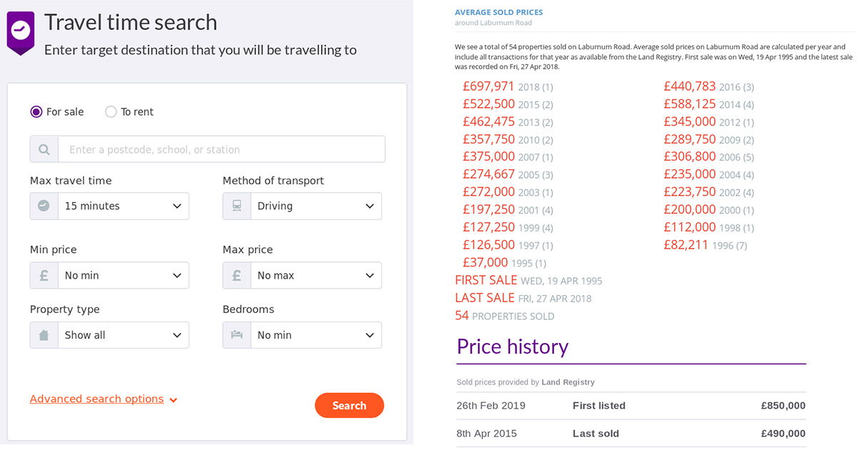
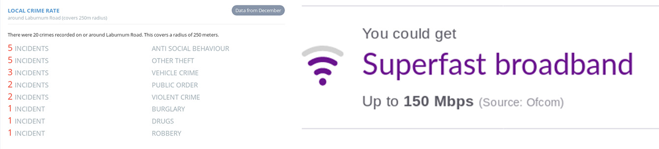
As professionals in the sector say, location, location and location are the three most important issues that must be taken into account when choosing a home. The location is an element that link issues as diverse as the distance to our points of interest (workplace, schools, hospitals or access to the public transport network), neighborhood security, air quality, neighborhood demographics, noise level and even energy consumption. Whether we change location or just neighborhood, having as much information as possible about a location we are considering moving is essential to make a good choice. These are just some examples of questions that we usually ask and that can or could be answered with services based on open data and that are common in other countries, either through free services, or payment:
- From which locations can I access to point X (for example, our work center) in less than 40 minutes? / What was the last transactions related to a certain property and what hawas its economic value? And other properties in the area?
-
What broadband services and other types of supplies are available in one location?
- What locations in my city are less than 1 km far away from a school with the highest score in the administration ranking? / What is the demographic distribution (average age, average income, etc.) of a certain area?
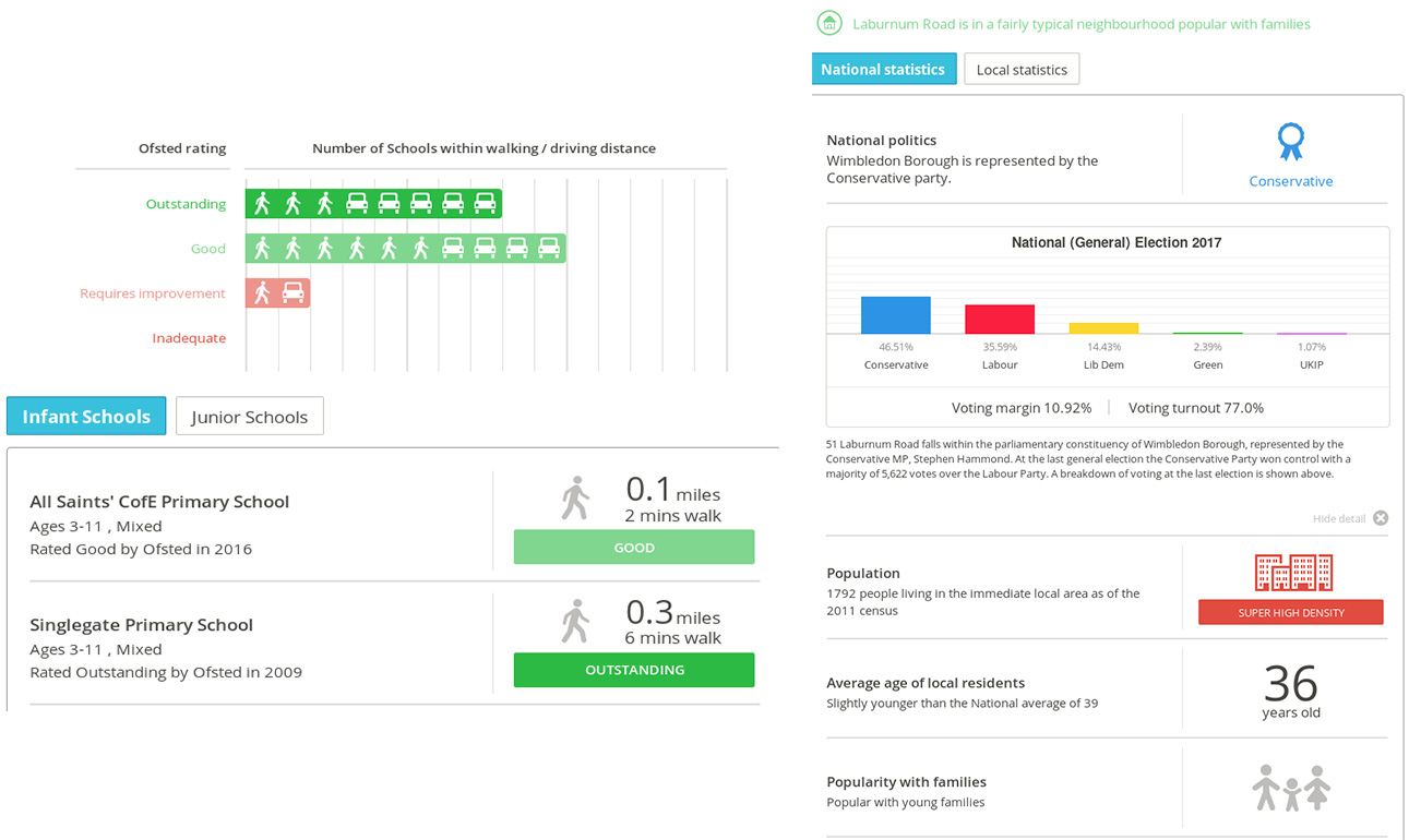
- What is the level of noise or environmental pollution of a given street? / What kind of public facilities are available near a house?
Traditionally we have answered these types of questions in a partial and unstructured way, based on the often informal and subjective information that we obtain from unreliable sources.
Despite the amount of time we spend finding the place where we are going to reside, we often discover many things that we do not like that are important to us and our quality of life. Basically we all have different priorities and some, as we have seen, could be solved thanks to open data that is already available in some countries and could be in Spain as well.
If we review leading real estate portals in the United States such as Zillow or in the United Kingdom as Zoopla, it is easy to see differences with the most used Spanish portals in terms of the information related to location that they provide for each property. And it is not difficult to establish a relationship between this difference and the availability of open data in the areas we have described.
Even in these countries, there is a wide margin for improvement to provide better information. This is covered, in part, by services such as Neighbourhood Scout in the United States, or CheckMyStreet or PropertyDetective in the United Kingdom. These services are largely based on the added value that these companies or projects bring to open data on demography, pollution or security, or data from the property registry itself.
In short, as citizens, we make much uninformed decisions that can sometimes have great consequences. Some of these decisions could be substantially improved with a greater availability of open data in areas where these data are being collected anyway by different administrations in the exercise of their functions.
Content prepared by Jose Luis Marín, Head of Corporate Technology Startegy en MADISON MK and Euroalert CEO.
Contents and points of view expressed in this publication are the exclusive responsibility of its author.
Noticia
After months of work, the second edition of the Barcelona Dades Obertes Challenge has come to end. Leading by the City Council of Barcelona and with the collaboration of the Consorci d'Educació de Barcelona and CESIRE, the project seeks to promote the knowledge and use of open data in schools in the city.
The final act took place on May 8 at the Fábrica de Creació de Fabra i Coats. In front of more than 300 attendees, Laia Servera, journalist and director of InfoK - the news program of Super3, the children's channel of Catalonian Television - acted as master of ceremonies. The event was also attended by Màrius Boada i Pla, Director of the Municipal Office of Dades, responsible for opening and closing the session, and national and international experts through video-conference: Martin Alvarez Espinar, director in Spain of the World Wide Web Consortium (W3C), Antje Kirchner, Survey Methodologist and head of the BigSurv18 congress, Esther Huyer, representative of the European Data Portal, and Taisuke Matsuzaki, representative of the Kobe City Council who commented on the experience of the World Data Viz Challenge 2018 Barcelona-Kobe .
During the event, the students of the 8 finalist centres had the opportunity to present and defend their work. After the jury deliberation, the prizes were awarded as follows:
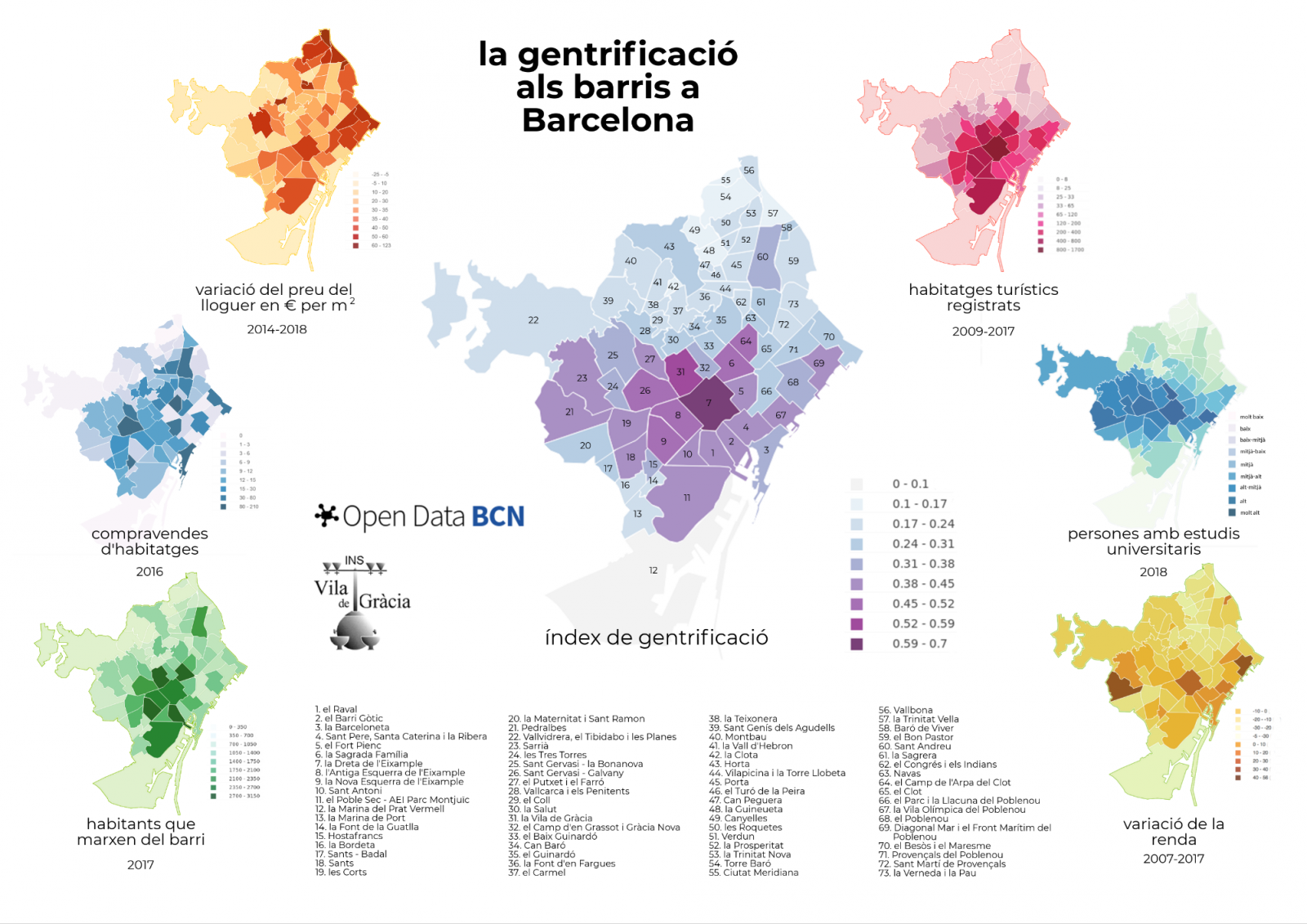
- The first prize went to the Institut Vila de Gràcia in Barcelona, with the project "La gentrificació als barris a Barcelona" (Gentrification in Barcelona neighbourhoods). The objective of the project was to show the process of urban transformation caused by strategic speculative actions that cause the displacement of the original population from one neighbourhood to another. To do this, the students developed a gentrification index, using datasets such as Number of inhabitants that leave their neighbourhoods, Purchase in relation to total housing or Rent variation in € / m2.
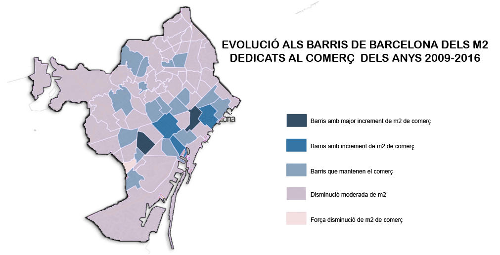
- The second prize went to the Institut Lluïsa Cura with "Evolució del comerç als barris de Barcelona" (Commerce evolution in Barcelona neighbourhoods). With this projects, the students wanted to confirm that traditional commerce was losing market share due to international brand stores and new forms of small convenience stores. For this, they used data related to the surface of the cadastral premises in Barcelona city.
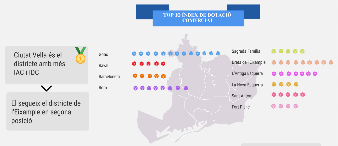
- The third prize went to the Institut Joan Brossa and his "On locate the meva botiga to Barcelona?" (Where to locate my store in Barcelona?). The analysis was based on the comparison of the Commercial Endowment Index and the Commercial Attraction Index.
Highlight the great effort that teachers and students have made one more year to create very interesting projects. You can learn more about the winning projects and the rest of the finalist projects here.
Congratulations to the winners and all the participants! Now we only have to wait for the third edition 2020, which will surely be also a success.
Empresa reutilizadora
Clikalia is a Spanish proptech that was born with the aim of converting the complex and slow processes of buying and selling real estate, in simple and fast processes providing immediate liquidity to sellers buying their home in just seven days. The key to its success lies in its strong commitment to technology and the digitalization of all its processes.
Noticia
Following initial contacts with Open Data and Smart Cities, the attendees at the International Open Data Conference enjoyed a second session dedicated to Open Data and Cities, moderated by Stephen Larrick from Sunlight Foundation, which gathered two experts from government bodies and two members of civil society to continue with the presentation of success cases worldwide.
It is estimated that 80% of Latin American population will live in cities in 2050. This demographic flow will arise new challenges in transport, education, waste management o housing, priority areas where open data can be a tool and response to those problems in future. The Inter-American Development Bank operates in this context, its representative Antonio Moneo was responsible for starting this panel describing the work of the IADB in the promotion of open data as the solution for current challenges in cities.
Within the different programs, the IADB helps and teaches towns in Latin America the potential of open data to face public problems and their possible impact to improve the life quality in urban areas. Thus, the Bank has helped Argentinian cities in their urbanistic planning, villages in Ecuador to manage natural disasters or Rio Janeiro in Brazil with the Zika epidemic. After all, according to Moneo’s words, in any process of information openness, the data are not the most important aspect, but the collaboration arose during the process to respond to specific necessities.
In the same continent, Eric Resee presented the project developed by the independent organization Bloomberg Philantrophics “What works cities: building capacity for open data in mid-sized cities”. An initiative within the Govex project which works with a network of 39 north american cities that lack of the necessary tools to re-use the open data in an efficient way. The entity helps those towns create sustainable open data programs that promote transparency and citizen participation. In this way, local governments would be able to incorporate data in their decision making to improve the operations in the city.
After his speech, it was local government representatives’ turn. Víctor Moran, from Zaragoza City Council, explained how the city’s open data portal works from the technical point of view and, lastly, Zira Rivera, coordinador of Smart-Dublin, showed the local initiative Dublinked, whose goal is promoting the development of innovative solutions based on open data, using the city as a test bed. Concurrently, this program plays two important roles: on one hand, it is an open data repository, published last march, with more than 300 datasets available for their re-use. And it is also a network that organizes regular events and activities to create an ecosystem for big and small companies, researches, public bodies and citizens interested in data.
In this regard, Zaira Rivera showed several projects such as DublinDashboard that provides visualizations based on open data from different sources or the funding program developed by the County Council to find solutions to road safety problems in the city, based on local open data.
After their speeches, an interesting discussion started where attendees had the opportunity to share their doubts with the experts. The global challenge that any Smart Cities addresses was highlighted: opening and bringing the accurate information for the specific needs of the citizen. Moreover, different methods to measure the impact of open data policies were analyzed showing how each project uses different performance indicators to assess its success.
In short, idea and knowledge sharing, real cases and, above all, commitment to build more intelligent and effective urban areas were the joint points of the community gathered at this session in the International Conference which, in its last edition, showed the good health of the Smart City and Open Data sector in the world.
Noticia
Every day the need of information increases in urban areas. The cities are becoming sophisticated ecosystems that, using the technological advances, are able to respond to the demands which arise in sectors so diverse as transport, health, education, waste management or infraestructures. In this context, open data can help us understand and interact in a more sustainable and effective way with cities. The openness and re-use of local public information lets us know in real time the bus schedules, localize the nearest retail business or identify the best neighborhood to buy a house. The development of Smart Cities cannot be understood nowadays without open data.
On the occasion of the last International Open Data Conference, Madrid was the setting of different events that, along the week, analyzed the impact of open data in the cities. Within the program of activities previous to IODC, the Open Data Summit gathered the open data community in the Madrid’s exhibition centre Media-lab Prado in order to find solutions to the challenges of the Smart Cities related to open data policies, urbanism, environment and competitivity.
The Conference itself dedicated several sessions exclusively to this area such as the panel A global marketplace for city data or the meeting about the OjoalData100 initiative to harmonize datasets in Smart Cities. Concurrently, IODC organized two tables in the first day to show success cases around the world which prove the perfect couple formed by open data and smart cities. A large group of national and international experts showed the attendees projects aimed at promoting Smart Cities through open data.
Sergio Fdez Balaguer from Empresa Municipal de Transportes of Madrid was in charge of starting the first session, moderated by Jean-Noé Landry, executive director of Open Northe- Canadian Open Government Partnership Civil Society Network. With approximately 1.5 million passengers per day and more than 85 million kilometres driven per year, this public entity has its own open data portal since 2011; platform that, nowadays, has 800 developers registered and receives each month 35 million hits with data requests. Thanks to the change of mind and the commitment to information openness of EMT, till 40 official apps have been created by third parties. The expert also talked about the project Mobility Labs Madrid, an open and interoperable platform where users can publish and re-use data, promoting the information sharing between the citizens and the local body.
The British initiative MediaMill, presented by Andy Dickinson, also showed the potential of open data in the cities. Despite of UK is one of the open data leaders in the world, only 4% of the 18.000 datasets from the national catalogue belong to local governments. The goal of MediaMill project is promoting the development of open source and open data platforms in two specific regions in England: Leeds and York. This program identifies ways that local data can be transformed into media stories and visualizations that help citizens understand the environment in which they live, improving their quality of live and active participation.
The second international practice case comes from Asia. The success case, Jakarta Smart City shown by Sinitra A. Punti proved how that platform uses the Information Technologies to empower the citizen, who re-uses and produces urban data, track the government activities and improve the public services in the city.
Lastly, Daniel Sarasa, responsible for Smart City division at Zaragoza City Council, explained to those present the role played by the Aragon’s capital in the international project CITYKeys, whose aim is creating a methodology to assess and compare the Smart Cities policies in Europe. Sarasa took this opportunity to highlight the importance of maximising the local community talent to develop the Smart Cities through the citizen collaboration and the organization of events -such as hackathons- that gather the different stakeholders looking for innovative solutions based on open data.
All the examples shown in this session at IODC were just a small sampling of the potential offered by the binomial: open data and Smart Cities. Thanks to open data, it is possible to establish mechanisms of transparency and citizen participation, improving the interoperability between the public administrations and the society, and, increasing, as a result, the access to public sector information and the intelligence in the cities.