
Description
Image segmentation is a method that divides a digital image into subgroups (segments) to reduce its complexity, thus facilitating its processing or analysis. The purpose of segmentation is to assign labels to pixels to identify objects, people, or other elements in the image.
Image segmentation is crucial for artificial vision technologies and algorithms, but it is also used in many applications today, such as medical image analysis, autonomous vehicle vision, face recognition and detection, and satellite image analysis, among others.
Segmenting an image is a slow and costly process. Therefore, instead of processing the entire image, a common practice is image segmentation using the mean-shift approach. This procedure employs a sliding window that progressively traverses the image, calculating the average pixel values within that region.
This calculation is done to determine which pixels should be incorporated into each of the delineated segments. As the window advances along the image, it iteratively recalibrates the calculation to ensure the suitability of each resulting segment.
When segmenting an image, the factors or characteristics primarily considered are:
-
Color: Graphic designers have the option to use a green-toned screen to ensure chromatic uniformity in the background of the image. This practice enables the automation of background detection and replacement during the post-processing stage.
-
Edges: Edge-based segmentation is a technique that identifies the edges of various objects in a given image. These edges are identified based on variations in contrast, texture, color, and saturation.
-
Contrast: The image is processed to distinguish between a dark figure and a light background based on high-contrast values.
These factors are applied in different segmentation techniques:
-
Thresholds: Divide the pixels based on their intensity relative to a specified threshold value. This method is most suitable for segmenting objects with higher intensity than other objects or backgrounds.
-
Regions: Divide an image into regions with similar characteristics by grouping pixels with similar features.
-
Clusters: Clustering algorithms are unsupervised classification algorithms that help identify hidden information in the images. The algorithm divides the images into groups of pixels with similar characteristics, separating elements into groups and grouping similar elements in these groups.
-
Watersheds: This process transforms grayscale images, treating them as topographic maps, where the brightness of pixels determines their height. This technique is used to detect lines forming ridges and watersheds, marking the areas between watershed boundaries.
Machine learning and deep learning have improved these techniques, such as cluster segmentation, and have also generated new segmentation approaches that use model training to enhance program capabilities in identifying important features. Deep neural network technology is especially effective for image segmentation tasks.
Currently, there are different types of image segmentation, with the main ones being:
- Semantic Segmentation: Semantic image segmentation is a process that creates regions within an image and assigns semantic meaning to each of them. These objects, also known as semantic classes, such as cars, buses, people, trees, etc., have been previously defined through model training, where these objects are classified and labeled. The result is an image where pixels are classified into each located object or class.
- Instance Segmentation: Instance segmentation combines the semantic segmentation method (interpreting the objects in an image) with object detection (locating them within the image). As a result of this segmentation, objects are located, and each of them is individualized through a bounding box and a binary mask, determining which pixels within that window belong to the located object.
- Panoptic Segmentation: This is the most recent type of segmentation. It combines semantic segmentation and instance segmentation. This method can determine the identity of each object because it locates and distinguishes different objects or instances and assigns two labels to each pixel in the image: a semantic label and an instance ID. This way, each object is unique.
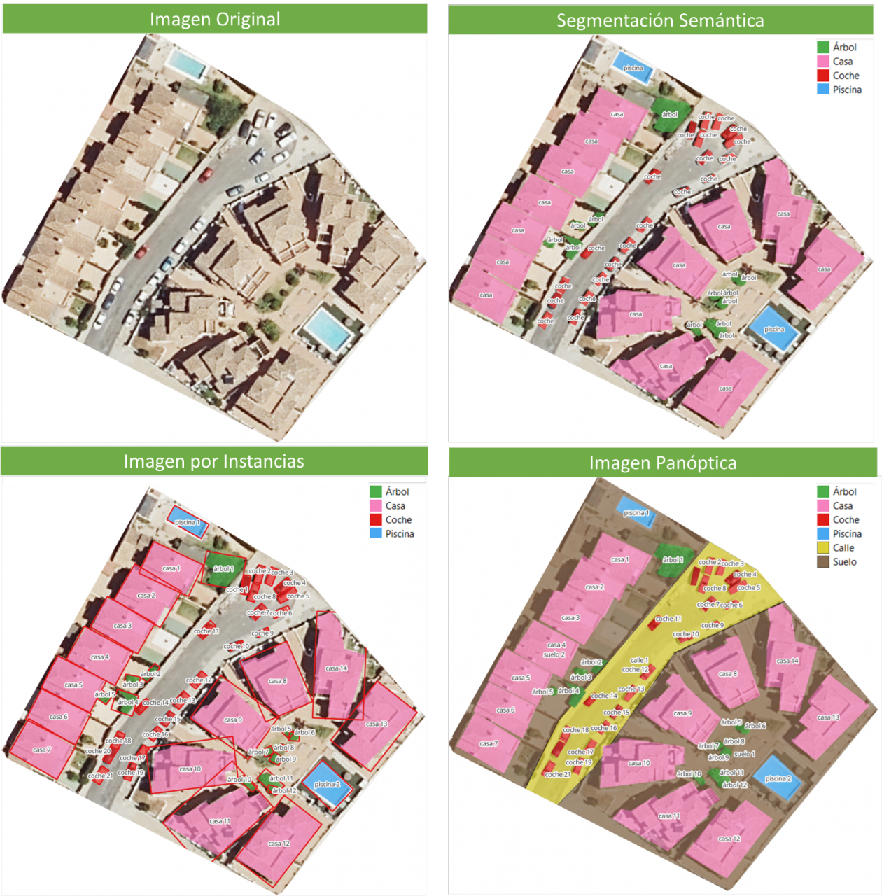
In the image, you can observe the results of applying different segmentations to a satellite image. Semantic segmentation returns a category for each type of identified object. Instance segmentation provides individualized objects along with their bounding boxes, and in panoptic segmentation, we obtain individualized objects and also differentiate the context, allowing for the detection of the ground and street regions.
Meta's New Model: SAM
In April 2023, Meta's research department introduced a new Artificial Intelligence (AI) model called SAM (Segment Anything Model). With SAM, image segmentation can be performed in three ways:
-
By selecting a point in the image, SAM will search for and distinguish the object intersecting with that point and find all identical objects in the image.
-
Using a bounding box, a rectangle is drawn on the image, and all objects found in that area are identified.
-
By using keywords, users can type a word in a console, and SAM can identify objects that match that word or explicit command in both images and videos, even if that information was not included in its training.
SAM is a flexible model that was trained on the largest dataset to date, called SA-1B, which includes 11 million images and 1.1 billion segmentation masks. Thanks to this data, SAM can detect various objects without the need for additional training.
Currently, SAM and the SA-1B dataset are available for non-commercial use and research purposes only. Users who upload their images are required to commit to using it solely for academic purposes. To try it out, you can visit this GitHub link.
In August 2023, the Image and Video Analysis Group of the Chinese Academy of Sciences released an update to their model called FastSAM, significantly reducing processing time with a 50 times faster execution speed compared to the original SAM model. This makes the model more practical for real-world usage. FastSAM achieved this acceleration by training on only 2% of the data used to train SAM, resulting in lower computational requirements while maintaining high accuracy.
SAMGEO: The Version for Analyzing Geospatial Data
The segment-geospatial package developed by Qiusheng Wu aims to facilitate the use of the Segment Anything Model (SAM) for geospatial data. For this purpose, two Python packages, segment-anything-py and segment-geospatial, have been developed, and they are available on PyPI and conda-forge.
The goal is to simplify the process of leveraging SAM for geospatial data analysis, allowing users to achieve it with minimal coding effort. These libraries serve as the basis for the QGIS Geo-SAM plugin and the integration of the model in ArcGIS Pro.
En la imagen se pueden observar los resultados de aplicar las distintas segmentaciones a una imagen satelital. La segmentación semántica devuelve una categoría por cada tipo de objeto identificado. La segmentación por instancia devuelve los objetos individualizados y la caja delimitadora y, en la segmentación panóptica, obtenemos los objetos individualizados y el contexto también diferenciado, pudiendo detectar el suelo y la región de calles.
Conclusions
In summary, SAM represents a significant revolution not only for the possibilities it opens in terms of editing photos or extracting elements from images for collages or video editing but also for the opportunities it provides to enhance computer vision when using augmented reality glasses or virtual reality headsets.
SAM also marks a revolution in spatial information acquisition, improving object detection through satellite imagery and facilitating the rapid detection of changes in the territory.
Content created by Mayte Toscano, Senior Consultant in Data Economy Technologies.
The content and viewpoints reflected in this publication are the sole responsibility of the author.
Comments