Evento
Spatial and geospatial data are essential for decision-making, spatial planning and resource management. The ability to visualise and analyse data in a spatial context offers valuable tools to address complex challenges in areas ranging from defence to sustainability. Participating in events that address these issues not only broadens our knowledge, but also fosters collaboration and innovation in the sector.
In this post, we present two upcoming events dealing with geospatial data and its most innovative uses. Don't miss them!
II Conference on Geospatial Intelligence: Territory and Defence
The Instituto Geográfico de Aragón (IGEAR) in collaboration with the Academia General Militar, the Centro Universitario de la Defensa and Telespazio Ibérica, has organized the second edition of the Jornada de Inteligencia Geoespacial: Territory and Defence, an event that will bring together professionals from the sector to explore how geospatial data can optimize strategies in the field of security and territorial management.
During the next 21 November, the crown room of the Pignatelli Building in Zaragoza will bring together speakers and attendees to discuss the impact of geospatial intelligence in Spain. The event will be open to a maximum of 100 attendees by invitation.
Geospatial intelligence, or GEOINT for short, focuses on understanding the dynamics occurring within a given geographic space.To achieve this, GEOINT relies on detailed analysis of imagery, databases and other relevant information, based on the idea that, although the circumstances surrounding each situation may vary, there is one common characteristic: all action takes place at specific geographic coordinates.
GEOINT is a very broad field that can be applied both in the military field, to execute movements by analyzing the terrain, and in the scientific field , to study environments, or even in the business field, to help adapt census, historical, meteorological, agricultural and geological information to commercial uses.
The II Geospatial Intelligence Conference will present case studies and technological advances and will promote discussions on the future of geospatial intelligence in defense contexts. For more details, you can visit the event's website.
- When? On 21 November 2024 at 8:00h.
- Wheree? Crown Hall of the Pignatelli Building. Paseo María Agustín, 36. Zaragoza.
- How to access? Through this link.
XV Edition of the Iberian Conference on Spatial Data Infrastructures (JIIDE) and III geoEuskadi
This year, the Board of Directors of the Geographic Information Infrastructure of Spain (CODIIGE) is jointly organizing the Iberian Conference on Spatial Data Infrastructures (JIIDE ) and the III geoEuskadi Kongresua Congress. Both events aim to enhance and promote activities related to geographic information in various sectors, covering both the publication and standardized accessibility of geographic data as well as its production, processing and exploitation.
On the one hand, in the JIIDE collaborate the Direção-Geral do Território de Portugal, the Instituto Geográfico Nacional de España, through the Centro Nacional de Información Geográfica, and the Govern d'Andorra.
The geoEuskadi Kongresua is organised by the Directorate of Territorial Planning and Urban Agenda of the Basque Government. This year, all these entities will come together to carry out a single event under the slogan “The value of geospatial data”.
The conference will focus on new technological trends related to data accessibility and reuse, as well as current techniques for Earth observation and representation.
Digital geospatial data is a key driver for economic growth, competitiveness, innovation, job creation and social progress. Therefore, III geoEuskadi and the XV edition JIIDE 2024 will emphasize the importance of technologies, such as big data and artificial intelligence, to generate ideas that improve business decision making and the creation of systems that perform tasks that traditionally require human intervention.
In addition, collaboration for the co-production and harmonization of data between different administrations and organizations will be highlighted, something that continues to be essential to generate valuable geospatial data that can become true references. This is a time of renewal, driven by the revision of the INSPIRE Directive, the update of the regulations on environmental spatial data and the new regulations on open data and data governance that favor a modernization in the publication and reuse of these data.
During the event, examples of reuse of high-value datasets will also be presented, both through OGC APIs and through download services and interoperable formats.
The combination of these events will represent a privileged space to reflect on geographic information and will be a showcase for the most innovative projects in the Iberian Peninsula. In addition, there will be technical workshops to share specific knowledge and round tables to promote debate. To learn more about this event, visit the JIIDE portal..
- When? From 13 to 15 November.
- Where? Europa Conference Centre (Vitoria-Gasteiz).
- How do I register? Through this link.
Don't miss the opportunity to participate in these events that promote the advancement of the use of spatial and geospatial data. We encourage you to join this conference to learn, collaborate and contribute to the development of this constantly evolving sector.
Blog
The National Centre for Geographic Information publishes open geospatial data from the National Cartographic System, the National Geographic Institute and other organisations through web applications and mobile applications to facilitate access to and consultation of geographic data by citizens.
Geospatial data is published via web services and APIs for reuse, so in the case of high-value datasets, it can be used in a variety of ways high-value datasets such as geographic names, hydrography or addresses as required by the as required by the EUthe EU has already made these datasets available to the public by June 2024 as they are associated with major benefits for society, the environment and the economy.
But in the applications listed below, the geographic data are visualised and consulted through web services, so that for downloading the data, it is possible to use web services and APIs directly, through a platform accessible to any user with a wide range of geographic information, ranging from topographic maps to satellite images.
But not only data can be reused, also application software is reusable, for example, the Solar Energy Potential of Buildings visualiser which is based on a visualiser API, named API-CNIG and allows the same tool to be used for different thematic areas.
Some examples of applications are:

Solar Energy Potential of Buildings
Provides the photovoltaic capacity of a building according to its location and characteristics. It also provides the average over the year and a point grid to identify the best location for solar panels.
National Geographic Gazetteer
It is a toponym search engine that collects the names, official or standardised by the corresponding competent bodies , with geographical references.
Unified postal address calculator
It is a converter that allows to know the geographical coordinates (latitude and longitude in WGS84) of the postal addresses of a place, and vice versa. In both cases, the input file is a CSV file, supporting both coordinates and postal addresses.
Basic Maps of Spain
It facilitates connection to IGN services and to the CNIG download centre to obtain maps and routes. With this mobile application you can follow the routes of the National Parks or the stages of the Camino de Santiago. It allows you to plan excursions using maps, navigate and take guided tours, without the need for an internet connection after downloading data.
Map a la carte
It allows you to create a customised map using the printed series of the National Topographic Map at scales 1:25.000 and 1:50.000. It offers the possibility of defining its area, incorporating contents, personalising the cover, obtaining a pdf file and even acquiring paper copies by post.
IGN Earthquakes
It allows the reception and visualisation of all seismic events in Spain and its surroundings. It provides the distance to the epicentre of the seismic event and epicentral parameters, as well as the geolocation of the user's position and the epicentre.
Maps of Spain
It is a free mobile viewer ideal for hiking, cycling, running, skiing, etc., which uses as background cartography the services of the National Geographic Institute and another set of services from other Ministries, such as the Cadastral information of the plots provided by the General Directorate of Cadastre.
Camino de Santiago
It includes information of a cultural and practical nature on each of the stages (hostels, monuments, etc.), as well as a complete Pilgrim's Guide detailing what you should know before starting out on any of the routes. This application is based on ESRI software.
National Parks
Displays information on the history, fauna, flora and excursions in Spain's National Parks. It includes hundreds of points of interest such as information centres, accommodation, viewpoints, refuges and even routes through the parks, indicating their duration and difficulty. The app is available for download on Android e iOS. This application is based on ESRI software.
GeoSapiens IGN
It presents interactive maps, free to use and free of charge, to study the physical and political geography of Spain and the world. It consists of different games relating to the whole of Spain or by autonomous communities, the whole world and by continent.
In addition to the applications developed by the CNIG, which are also presented in this video this videothere are many other digital solutions developed by third parties that reuse open geospatial data to offer a service to society. For example, in the list of data reusing applications.gob.es you can find from a map that shows the fires that are active in Spain in real time in Spain in real time to an app that shows where the parking spaces for people with reduced mobility parking spaces for people with reduced mobility in each town.
In short, anyone can make use of the open geographic data of the National Cartographic System, the National Geographic Institute and other bodies published by the CNIG , thus extending the advantages offered by the availability of open geographic data. do you know of any other application resulting from the reuse of open data? You can send it to us at dinamizacion@datos.gob.es
Blog
Geographic data allow us to learn about the world around us. From locating optimal travel routes to monitoring natural ecosystems, from urban planning and development to emergency management, geographic data has great potential to drive development and efficiency in multiple economic and social areas. They are therefore considered high-value datasets by the European Commission, and have a specific obligations to make their publication accessible and interoperable.
In order to understand the real impact of this type of data, several reports and studies have been carried out. The following are several of them, which address the challenge of measuring the impact of geographic information.
Geospatial data in the Ministry of Transport and Sustainable Mobility. Impact of information co-produced by IGN and CNIG (2024)
- You can read the full report here.
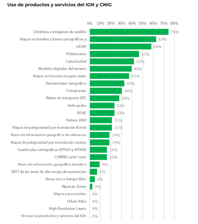
This report, produced by ASEDIE and CNIG, aims to draw conclusions about the use and perception of the services co-produced by National Geographic Institute (IGN) and National Centre for Geographic Information (CNIG) in order to understand the benefit they bring to the daily activity of the companies that use them and to society. For this purpose, a survey was carried out among companies using geospatial data, thanks to which a classification of companies reusing geographic data could be drawn up.
Of the 170 companies considered, 70.0% are self-employed and micro-enterprises (less than 10 employees). These companies are mainly located in the Community of Madrid (25.6%), Catalonia (16.3%), Andalusia (14%), Valencia (11.6%) and Castilla y León (11.6%). 53.3% claim to reuse data from Spatial Data Infrastructures (SDI) and 51% open data from INE, among others. The most used products are orthophotos and satellite images (74%), followed by vector maps and cartographic and topographic databases (63%), and LiDAR (58%).
In terms of economic impact, the report estimates an average impact of 35.7% on the sales of the companies surveyed. Specifically, open geographic information from the IGN and CNIG account for an impact of 12.4% of sales.
The report also includes the analysis of collected use cases, as well as in-depth interviews with companies in the sector as examples of best practices and, on the other hand, updates the information from Asedie's annual report on the Data Economy in its 2023 infomediary scope with respect to the economic data of the geographic subsector.
Economic benefits of the SDI central node by CNIG and University of Leuven (2021)
- You can read the full report here.
This document develops and tests a methodology for estimating the economic benefits generated by the Spanish Spatial Data Infrastructure (IDEE), which establishes the publication and accessibility of spatial data through free geographic web services for viewing and downloading produced by cartographic, environmental, cadastral and land observation organisations at national, regional and local level since 2004, in accordance with norms, standards and recommendations that guarantee their interoperability.
The study was to answer the question of what would happen if the NSDI were to disappear. For the study, only the central node of the NSDIE was considered, understanding as such the geographic services and data co-produced among the partners of the National Cartographic System, and focusing on web map services (WMS) and map tiles (WMTS). The nodes of ministries, autonomous communities and local entities were not part of its scope.
Two investigation paths were used to carry out the calculation:
- Comparison with the costs of using Google Maps. The application of the different scenarios led to a profit/value of the 6 WMTS and 13 WMS of minimum 355,646 and maximum 891,144 euros.
- Comparison with other countries' charges for the use of their data and services. Despite the difficulties in calculating the rate per application, due to the existence of different approaches in each country, the total value of the FDIE was estimated at between 34,000 and 14 million euros.
This report joins others produced by the NSDI, such as these documents to estimate the average cost of metadata generation or the implementation of visualisation and download services for Inspire-compliant datasets, both carried out in 2019.
In order to allow other organisations to adapt the study to their particularities, an Excel file has been created, as a calculator, with the following calculation template.
ICEARAGON and ARAGEA Performance Report by the Government of Aragon (2024)
- You can read the full report here.
Regional governments are also interested in knowing the impact of their geographic information services. This is the case of the Government of Aragon, which recently presented a report on the performance of the Spatial Knowledge Infrastructure of Aragon (ICEARAGON) and the Active Geodesy Network of Aragon (AREAGA).
In total, these services are estimated to have saved almost two million euros for all Aragonese citizens by 2023. According to the report, ICEARAGÓN received almost 5 million visits in 2023, an increase of 58.6% over 2022. These users made 1.7 million downloads. Most of the information downloaded (47.8%) refers to environmental layers. Information on administrative boundaries (13.8%) and maps of Aragon (13.4%) were also very successful. Regarding the user profile, 71% are from the surveying field and 27% belong to the agricultural sector.
These reports serve as a basis for the work of the European Commission on a regular basis, compiling progress in the different areas of INSPIRE implementation. As a result of this work, annual reports are generated for each country, including a section on costs and benefits.
All this work on measuring and estimating benefits highlights the economic value of providing geographic data and services to society. As a result, new products and services can be created that boost the economy of the whole country and provide benefits to all its citizens.
Blog
In the vast technological landscape, few tools have made as deep a mark as Google Maps. Since its inception, this application has become the standard for finding and navigating points of interest on maps. But what happens when we look for options beyond the ubiquitous map application? In this post we review possible alternatives to the well-known Google application.
Introduction
At the beginning of 2005, Google's official blog published a brief press release in which they presented their latest creation: Google Maps. To get an idea of what 2005 was like, technologically speaking, it is enough to look at the most groundbreaking mobile terminals that year:

Imagen credits: Cinco móviles que marcaron el año 2005
Some of us still remember what the experience (or lack of experience) of running apps on these terminals was like. Well, in that year the first version of Google Maps was launched, allowing us to search for restaurants, hotels and other elements near our location, as well as to find out the best route to go from point A to point B on a digital version of a map of our city. In addition, that same year, Google Earth was also launched, which represented a real technological milestone by providing access to satellite images for almost all citizens of the world.
Since then, Google's digital mapping and navigation ecosystem, with its intuitive interface and innovative augmented reality features, has been a beacon guiding millions of users on their daily journeys.
But what if we are looking for something different? What alternatives are there for those who want to explore new horizons? Join us on this journey as we venture into the fascinating world of your competitors. From more specialized options to those that prioritize privacy, we will discover together the various routes we can take in the vast landscape of digital navigation.
Alternatives to Google Maps
Almost certainly some of you readers have seen or used some of the open source alternatives to Google Maps, although you may not know it. Just to mention some of the most popular alternatives:
-
OpenStreetMap (OSM): OpenStreetMap is a collaborative project that creates a community-editable map of the world. It offers free and open geospatial data that can be used for a variety of applications, from navigation to urban analysis.
-
uMap: uMap is an online tool that allows users to create custom maps with OpenStreetMap layers. It is easy to use and offers customization options, making it a popular choice for quick creation of interactive maps.
-
GraphHopper: GraphHopper is an open source routing solution that uses OpenStreetMap data. It stands out for its ability to calculate efficient routes for vehicles, bicycles and pedestrians, and can be used as part of custom applications.
-
Leaflet: Leaflet is an open source JavaScript library for interactive maps compatible with mobile devices. It is probably the most widespread library because of its low KB weight and because it includes all the mapping functions that most developers might need.
-
Overture Maps: While the previous four solutions are already widely established in the market, Overture Maps is a new player. It is a collaborative project to create interoperable open maps.
Of all of them, we are going to focus on OpenStreetMap (OSM) and Overture Maps.
Open Street Maps: an open and collaborative tool
Of the aforementioned solutions, probably the most widespread and well-known is Open Street Maps.
OpenStreetMap (OSM) stands out as one of the best open source alternatives to Google Maps for several reasons:
-
First, the fundamental characteristic of OpenStreetMap lies in its collaborative and open nature, where a global community contributes to the creation and constant updating of geospatial data.
-
In addition, OpenStreetMap provides free and accessible data that can be used flexibly in a wide range of applications and projects. To quote verbatim from their website: OpenStreetMap is open data: you are free to use it for any purpose as long as you credit OpenStreetMap and its contributors. If you modify or build upon the data in certain ways, you may distribute the result only under the same license. See the Copyright and License page for more details.
-
The ability to customize maps and the flexibility of OpenStreetMap integration are also outstanding features. Developers can easily tailor maps to the specific needs of their applications by leveraging the OpenStreetMap API. This is the key to the development of an ecosystem of applications around OSM such as uMap, Leaflet or GraphHopper, among many others.
Overture Maps. A unique competitor
Perhaps, one of the most promising projects to have recently appeared on the global technology scene is Overture Maps. As indicated (last July of this year) by its foundation (OMF Overture Maps Foundation), it has released its first open dataset, marking a significant milestone in the collaborative effort to create interoperable open map products. The first Overture release includes four unique data layers:
-
Places of Interest (POIs)
-
Buildings
-
Transportation Network
-
Administrative Boundaries

Example coverage of public places worldwide identified in the initial project dataset. The first version of the overture maps dataset contains, among others, 59 million records of points of interest, 780 million buildings, transport networks and national and regional administrative boundaries worldwide.
These layers, which merge various open map data sources, have been validated and contrasted through quality checks and are released under the Overture Maps data schema, made public in June 2023. Specifically, the Places of Interest layer includes data on more than 59 million places worldwide. This dataset is presented as a fundamental building block for navigation, local search and for various location-based applications. The other three layers include detailed building information (with more than 780 million building footprints worldwide), a global transportation network derived from the OpenStreetMap project, and worldwide administrative boundaries with regional names translated into more than 40 languages.
Perhaps one of the most significant pieces of information in this announcement is the number of collaborators that have come together to realize this project. The Overture collaboration, founded in December 2022 by Amazon Web Services (AWS), Meta, Microsoft and TomTom, now boasts more than a dozen geospatial and technology companies, including new members such as Esri, Cyient, InfraMappa, Nomoko, Precisely, PTV Group, SafeGraph, Sanborn and Sparkgeo. The central premise of this collaboration is the need to share map data as a common asset to support future applications.
As a good open source project, the Overture Foundation has made available to the development community a Github repository where they can contribute to the project.
In short, digital maps, their corresponding geospatial data layers, navigation and photo-geolocation capabilities are vital and strategic assets for social and technological organizations around the world. Now, with the 20th anniversary of the birth of Google Maps just around the corner, there are good open source alternatives and the big players in the international technology landscape are coming together to generate even more valuable spatial assets. Who will win this new race? We don't know, but we will keep a close eye on the current news on this topic.
Blog
On September 8, the webinar \"Geospatial Trends 2023: Opportunities for data.europa.eu\" was held, organized by the Data Europa Academy and focused on emerging trends in the geospatial field. Specifically, the online conference addressed the concept of GeoAI (Geospatial Artificial Intelligence), which involves the application of artificial intelligence (AI) combined with geospatial data.
Next, we will analyze the most cutting-edge technological developments of 2023 in this field, based on the knowledge provided by the experts participating in the aforementioned webinar.
What is GeoAI?
The term GeoAI, as defined by Kyoung-Sook Kim, co-chair of the GeoAI Working Group of the Open Geospatial Consortium (OGC), refers to \"a set of methods or automated entities that use geospatial data to perceive, construct (automate), and optimize spaces in which humans, as well as everything else, can safely and efficiently carry out their geographically referenced activities.\"
GeoAI allows us to create unprecedented opportunities, such as:
- Extracting geospatial data enriched with deep learning: Automating the extraction, classification, and detection of information from data such as images, videos, point clouds, and text.
- Conducting predictive analysis with machine learning: Facilitating the creation of more accurate prediction models, pattern detection, and automation of spatial algorithms.
- Improving the quality, uniformity, and accuracy of data: Streamlining manual data generation workflows through automation to enhance efficiency and reduce costs.
- Accelerating the time to gain situational knowledge: Assisting in responding more rapidly to environmental needs and making more proactive, data-driven decisions in real-time.
- Incorporating location intelligence into decision-making: Offering new possibilities in decision-making based on data from the current state of the area that needs governance or planning.
Although this technology gained prominence in 2023, it was already discussed in the 2022 geospatial trends report, where it was indicated that integrating artificial intelligence into spatial data represents a great opportunity in the world of open data and the geospatial sector.
Use Cases of GeoAI
During the Geospatial Trends 2023 conference, companies in the GIS sector, Con terra and 52ºNorth, shared practical examples highlighting the use of GeoAI in various geospatial applications.
Examples presented by Con terra included:
- KINoPro: A research project using GeoAI to predict the activity of the \"black arches\" moth and its impact on German forests.
- Anomaly detection in cell towers: Using a neural network to detect causes of anomalies in towers that can affect the location in emergency calls.
- Automated analysis of construction areas: Aiming to detect building areas for industrial zones using OpenData and satellite imagery.
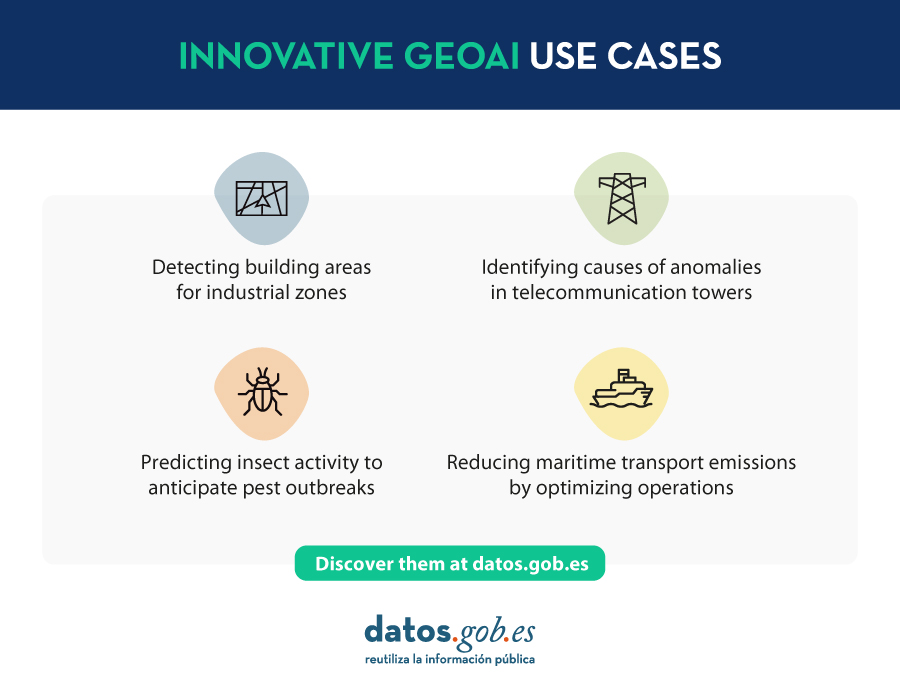
On the other hand, 52ºNorth presented use cases such as MariData, which seeks to reduce emissions from maritime transport by using GeoAI to calculate optimal routes, considering ship position, environmental data, and maritime traffic regulations. They also presented KI:STE, which applies artificial intelligence technologies in environmental sciences for various projects, including classifying Sentinel-2 images into (un)protected areas.
These projects highlight the importance of GeoAI in various applications, from predicting environmental events to optimizing maritime transport routes. They all emphasize that this technology is a crucial tool for addressing complex problems in the geospatial community.
GeoAI not only represents a significant opportunity for the spatial sector but also tests the importance of having open data that adheres to FAIR principles (Findable, Accessible, Interoperable, Reusable). These principles are essential for GeoAI projects as they ensure transparent, efficient, and ethical access to information. By adhering to FAIR principles, datasets become more accessible to researchers and developers, fostering collaboration and continuous improvement of models. Additionally, transparency and the ability to reuse open data contribute to building trust in results obtained through GeoAI projects.
Reference
| Reference video | https://www.youtube.com/watch?v=YYiMQOQpk8A |
Noticia
The rise of smart cities, the distribution of resources during pandemics or the fight against natural disasters has awakened interest in geographic data. In the same way that open data in the healthcare field helps to implement social improvements related to the diagnosis of diseases or the reduction of waiting lists, Geographic Information Systems help to streamline and simplify some of the challenges of the future, with the aim of making them more environmentally sustainable, more energy efficient and more livable for citizens.
As in other fields, professionals dedicated to optimizing Geographic Information Systems (GIS) also build their own working groups, associations and training communities. GIS communities are groups of volunteers interested in using geographic information to maximize the social benefits that this type of data can bring in collective terms.
Thus, by addressing the different approaches offered by the field of geographic information, data communities work on the development of applications, the analysis of geospatial information, the generation of cartographies and the creation of informative content, among others.
In the following lines, we will analyze step by step what is the commitment and objective of three examples of GIS communities that are currently active.
Gis and Beers
What is it and what is its objective?
Gis and Beers is an association focused on the dissemination, analysis and design of tools linked to geographic information and cartographic data. Specialized in sustainability and environment, they use open data to propose and disseminate solutions that seek to design a sustainable and nature-friendly environment.
What functions does it perform?
In addition to disseminating specialized content such as reports and data analysis, the members of Gis and Beers offer training resources dedicated to facilitating the understanding of geographic information systems from an environmental perspective. It is common to read articles on their website focused on new environmental data or watch tutorials on how to access open data platforms specialized in the environment or the tools available for their management. Likewise, every time they detect the publication of a new open data catalog, they share on their website the necessary instructions for downloading the data, managing it and representing it cartographically.
Next steps
In line with the environmental awareness that marks the project, Gis and Beers is devoting more and more effort to strengthening two key pillars for its content: raising awareness of the importance of citizen science (a collaborative movement that provides data observed by citizens) and promoting access to data that facilitate modeling without previously adapting them to cartographic analysis needs.
The role of open data
The origin of most of the open data they use comes from state sources such as the IIGN, Aemet or INE, although they also draw on other options such as those offered by Google Earth Engine and Google Public Data.
How to contact them?
If you are interested in learning more about the work of this community or need to contact Gis and Beers, you can visit their website or write directly to this email account.
Geovoluntarios
What is it and what is its objective?
It is a non-profit Organization formed by professionals experienced in the use and remote application of geospatial technology and whose objective is to cooperate with other organizations that provide support in emergency situations and in projects aligned with the Sustainable Development Goals.
The association's main objectives are:
- To provide help to organizations in any of the phases of an emergency, prioritizing help to non-profit, life-saving organizations or those supporting the third sector. Some of them are Red Cross, Civil Protection, humanitarian organizations, etc.
- Encourage digital volunteering among people with knowledge or interest in geospatial technologies and working with geolocated data.
- Find ways to support organizations working towards the Sustainable Development Goals (SDGs).
- Provide geospatial tools and geolocated data to non-profit projects that would otherwise not be technically or economically feasible.
What functions does it perform?
The professional experience accumulated by the members of geovolunteers allows them to offer support in tasks related to the analysis of geographic data, the design of models or the monitoring of special emergency situations. Thus, the most common functions carried out as an NGO can be summarized as follows:
- Training and providing means to volunteers and organizations in all the necessary aspects to provide aid with guarantees: geographic information systems, spatial analysis, RGPD, security, etc.
- Facilitate the creation of temporary work teams to respond to requests for assistance received and that are in line with the organization's goals.
- Create working groups that maintain data that serve a general purpose.
- Seek collaboration agreements with other entities, organize and participate in events and carry out campaigns to promote digital volunteering.
From a more specific point of view, among all the projects in which Geovolunteers has participated, two initiatives in which the members were particularly involved are worth mentioning. On the one hand, the Covid data project, where a community of digital volunteers committed to the search and analysis of reliable data was created to provide quality information on the situation being experienced in each of the different autonomous communities of Spain. Another initiative to highlight was Reactiva Madrid, an event organized by the Madrid City Council and Esri Spain, which was created to identify and develop work that, through citizen participation, would help to prevent and/or solve problems related to the pandemic caused by COVID-19 in the areas of the economy, mobility and society.
Next steps
After two years focused on solving part of the problems generated by the Covid-19 crisis, Geovolunteers continues to focus on collaborating with organizations that are committed to assisting the most vulnerable people in emergency situations, without forgetting the commitment that links them to meeting the Sustainable Development Goals.
Thus, one of the projects in which the volunteers are most active is the implementation and improvement of GeoObs, an app to geolocate different observation projects on: dirty spots, fire danger, dangerous areas for bikers, improving a city, safe cycling, etc.
The role of open data
For an NGO like Geovolunteers, open data is essential both to develop the solidarity tasks they carry out together with other associations, as well as to design their own services and applications. Hence, these resources are part of the new functionalities on which the Association wants to focus.
So much so that data collection marks a starting point for the pilot projects that can currently be found under the Geovolunteers umbrella. Without going any further, the application mentioned above is an example that demonstrates how generating data by observation can contribute to enriching the available open data catalogs.
GIS Community
What is it and what is its objective?
GIS Community is a virtual collective that brings together professionals in the field of geographic data and information systems related to the same sector. Founded in 2009, they disseminate their work through social networks such as Facebook, Twitter or Instagram from where, in addition, they share news and relevant information on geotechnology, geoprocessing or land use planning among other topics.
Its objective is none other than to contribute to expand the informative and interesting knowledge for the geographic data community, a virtual space with little presence when this project began its work on the Internet.
What functions does it perform?
In line with the objectives mentioned above, the tasks developed by SIG are focused on the sharing and generation of content related to Geographic Information Systems. Given the diversity of fields and sectors of action within the same field, they try to balance the content of their publications to bring together both those who seek information and those who provide opportunities. For this reason it is possible to find news about events, training, research projects, news about entrepreneurs or literature among many others.
Next steps
Aware of the weight they have as a community within the field of geographic data, from SIG they plan to strengthen four axes that directly affect the work of the project: organize lectures and webinars, contact organizations and institutions capable of providing funding for projects in the GIS area, seek entities that provide open geospatial information and, finally, get part of the private sector to participate financially in the education and training of professionals in the field of GIS.
The role of open data
This is a community that is closely linked to the universe of open data, because it shares content that can be used, supplemented and redistributed freely by users. In fact, according to its own members, there is an increasing acceptance and preference for this trend, with community collaborators and their own projects driving the debate and interest in using open data in all active phases of their tasks or activities.
How to contact them?
As in the previous cases, if you are interested in contacting Comunidad SIG you can do so through their Facebook page, Twitter or Instagram or by sending an email to the following email.
Communities like Gis and Beers, SIG or Geovolunteers are just a small example of the work that the GIS collective is currently developing. If you are part of any data community in this or any other field or you know about the work of communities that may be of interest in datos.gob.es, do not hesitate to send us an email to dinamizacion@datos.gob.es.
Geo Developers
What is it and what is its purpose?
Geodevelopers is a community whose objective is to bring together developers and surveyors in the field of geographic data. The main function of this community is to share different professional experiences related to geographic data and, for this purpose, they organize talks where everyone can share their experience and knowledge with the rest.
Through their YouTube channel it is possible to access the trainings and talks held to date, as well as to be aware of the next ones that may be held.
The role of open data
Although this is not a community focused on the reuse of open data as such, they use it to develop some projects and extract new learnings that they then incorporate into their workflows.
Next steps and contact
The main objective for the future of Geodevelopers is to grow the community in order to continue sharing experiences and knowledge with the rest of the GIS stakeholders. If you want to get in touch and follow the evolution of this project you can do it through its Twitter profile.
Evento
The pandemic situation we have experienced in recent years has led to a large number of events being held online. This was the case of the Iberian Conference on Spatial Data Infrastructures (JIIDE), whose 2020 and 2021 editions had a virtual format. However, the situation has changed and in 2022 we will be able to meet again to discuss the latest trends in geographic information.
Seville will host JIIDE 2022
Seville has been the city chosen to bring together all those professionals from the public administration, private sector and academia interested in geographic information and who use Spatial Data Infrastructures (SDI) in the exercise of their activities.
Specifically, the event will take place from 25 to 27 October at the University of Seville. You can find more information here.
Focus on user experience
This year's slogan is "Experience and technological evolution: bringing the SDI closer to citizens". The aim is to emphasise new technological trends and their use to provide citizens with solutions that solve specific problems, through the publication and processing of geographic information in a standardised, interoperable and open way.
Over three days, attendees will be able to share experiences and use cases on how to use Big Data, Artificial Intelligence and Cloud Computing techniques to improve the analysis capacity, storage and web publication of large volumes of data from various sources, including real-time sensors.
New specifications and standards that have emerged will also be discussed, as well as the ongoing evaluation of the INSPIRE Directive.
Agenda now available
Although some participations are still to be confirmed, the programme is already available on the conference website. There will be around 80 communications where experiences related to real projects will be presented, 7 technical workshops where specific knowledge will be shared and a round table to promote debate.
Among the presentations there are some focused on open data. This is the case of Valencia City Council, which will talk about how they use open data to obtain environmental equity in the city's neighbourhoods, or the session dedicated to the "Digital aerial photo library of Andalusia: a project for the convergence of SDIs and Open-Data".
How can I attend?
The event is free of charge, but to attend you need to register using this form. You must indicate the day you wish to attend.
For the moment, registration is open to attend in person, but in September, the website of the conference will offer the possibility of participating in the JIIDE virtually.
Organisers
The Jornadas Ibéricas de Infraestructuras de Datos Espaciales (JIIDE) were born from the collaboration of the Directorate General of Territory of Portugal, the National Geographic Institute of Spain and the Government of Andorra. On this occasion, the Institute of Statistics and Cartography of Andalusia and the University of Seville join as organisers.
Blog
Throughout history, geospatial data have allowed humankind to better understand its environment. When we talk about geographic or spatial data, we refer to data "that implicitly or explicitly refer to a location relative to the Earth", according to the Spanish Standard UNE 148004:2018. Generally, these data are accessible on maps, visualisers, mobile devices and other media helping us to move and manage the territory in a more efficient way, thus achieving greater progress.
Today, geospatial data remains of particular importance. According to a study by the European Open Data Portal, geospatial data is the second most reused data, behind only statistical data. Both individuals and companies use them to create tools to help citizens in their daily lives - when choosing the most appropriate route to reach a destination -, in management situations - such as fighting a fire - or when they want to disconnect through recreational elements - such as strategy games.
Given this demand, it is not surprising that there is a need for infrastructures that allow us to access this type of information in a harmonised and interoperable way, facilitating its reuse.
What is a Spatial Data Infrastructure (SDI)?
According to the website of the Ministry for Ecological Transition and the Demographic Challenge, a Spatial Data Infrastructure (SDI or IDE in Spanish) "is an information system made up of a set of resources dedicated to managing Geographic Information, available on the Internet, which meet a series of interoperability conditions, and which allow a user, using a simple browser, to use and combine them according to their needs". Through an SDI, geographic information is accessed on the Internet through web services and is catalogued (with metadata) for its location or search, considering regulations, technical documents, international norms and standards that guarantee its interoperability and harmonisation.
It is therefore a mechanism that facilitates the task of searching and accessing geographic data in a uniform manner. This is essential to promote their reuse through the development of digital solutions.
The Spatial Data Infrastructure of Spain (IDEE, in Spanish)
In Spain there are a multitude of geoportals and SDI nodes at state, regional and local level, which are centralised through the geoportal of the Spatial Data Infrastructure of Spain (IDEE). This is a project designed to merge the geographic data with which the Public Administrations of Spain work under the umbrella of the LISIGE and the Regulations of the INSPIRE Directive (Infrastructure for Spatial Information in Europe).
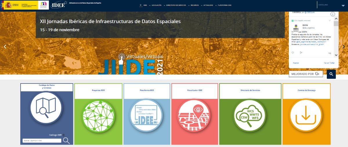
IDEE Geoportal: https://www.idee.es/
The main objective of the IDEE is to publish official geographic information for viewing and downloading and to offer the possibility of locating the data through its descriptions (metadata), so that the data is accessible, machine-readable, easy to locate and reusable. Today, re-use is generally free of charge. To achieve this goal, the NSDI is based on international standards and European regulations that make data interoperable and accessible through open formats.
In charge of coordinating the IDEE is the Consejo Directivo de la Infraestructura de Información Geográfica de España (CODIIGE), created by the Consejo Superior Geográfico, a governing body belonging to the Ministry of Transport, Mobility and Urban Agenda (MITMA). The CODIIGE is made up of representatives of the three levels of the Administration, experts from the Commissions of the High Geographic Council and experts in environmental policies.
The IDEE is part of the European SDI and publishes approximately 250 resources on the European Commission's Geoportal classified by subject.
Who participates in the IDEE?
As mentioned above, the IDEE is made up of the organisations responsible for the data that the European Commission has classified, identified and documented through the INSPIRE Directive Regulation 1089/2010, such as, for example:
- General Directorate of Cadastre, which publishes cadastral plots, buildings and addresses freely and free of charge through viewing and downloading services, allowing this data to be consulted on sites such as the Cadastre's Electronic Headquarters. It is worth highlighting its coordination with the Land Registry. Now any citizen can voluntarily request in a sale or purchase, or at any time, without waiting for the registration of a new act, the incorporation in the Land Registry of a cadastral graphic representation.
- MAPA and MITECO, which work jointly on the publication of data classified as priority data by the European Commission. Its publication is materialised in its IDE geoportal.
- National Centre for Geographic Information (CNIG), responsible for the Cartociudad project, which compiles and publishes freely and free of charge the addresses from the G.D. of Cadastre, the Post Office Group, the National Statistics Institute, the National Geographic Institute, the Autonomous Communities such as the Basque Country, the Community of Navarre, the Community of Valencia, La Rioja, the Balearic Islands and the Community of Madrid, and at a local level, the City Council of Cáceres and the Provincial Council of Madrid.
- Ministry for Ecological Transition and the Demographic Challenge, with its Gas Stations Geoportal application, for searching and visualising service stations, facilitates locating the most economical stations closest to the user through the use of location data.
Other organisations and some of their SDI projects can be consulted on this map.
Other services and web resources of the IDEE
Some time ago we wrote an article about the services and resources included in the IDEE Geoportal, and since then, this geoportal has been complemented with the recent publication of the IDEE Platform, whose main objective is to collect, for the developers of the geospatial community, software development initiatives, thus facilitating the reuse of resources.
In the resources section of the geoportal and the IDEE platform, sections continue to be offered that provide added value beyond the datasets themselves; these are resources published by different administrations and international organisations to facilitate decision-making. To the sections analysed in the previous article, we must add as a novelty a section dedicated to Open Resources on COVID-19, whose incorporation is due to the importance that spatial data are having in the management of this health crisis.
The IDEE also has a blog where questions of interest to all users interested in geographic data are collected.
Want to know more about IDEs?
The Ministry of Transport, Mobility and Urban Agenda has recently published a guide on Spatial Data Infrastructures, which covers the basic concepts, the legal framework, the web technologies needed to implement such an infrastructure, web services, information on how to catalogue geographic information (metadata) and other related topics.
In addition, if you are interested in publishing geographic data, we encourage you to read our "Practical Guide to Publishing Spatial Data", where you will find good practices and guidelines to facilitate the publication of spatial data efficiently on the Internet.
Content prepared by the datos.gob.es team.
Blog
Copernicus is one of the geospatial data programmes that is most in demand and the focus of attention of various organisations, private companies and citizens. The programme is run jointly by the European Space Agency (ESA) and the European Union through the European Environment Agency, and has two clear objectives: to observe the environment in order to support strategies for mitigating and adapting to climate change, to manage emergencies efficiently and to improve the security of each citizen; and to provide accurate and up-to-date information that is easily accessible to everyone.
The Copernicus programme provides data and information services without restrictions and free of charge on many areas of application thanks to the different technologies used, ranging from satellites in space - including Sentinel satellites - to sensor systems on land, at sea and in the air. Copernicus transforms the data obtained from the satellite into valuable information, thanks to the processing and analysis of the information, its integration with other sources, and the validation of the results.
Through these data, both private and public organisations can create products and services of great economic and social value. The Copernicus programme itself highlights three of these on its website that are linked to our country:
Carbon mapping of forest trees
Agresta S.Coop in collaboration with several Universities of Almeria (Spain) and Delaware (USA), has developed a new methodological approach to improve the national aerial carbon map. The ecosystems of the Iberian Mediterranean area are highly sensitive to climate change and it is therefore essential to monitor and manage organic carbon in these areas. Traditionally, LIDAR technology has been used to measure the carbon density of vegetation, but the data obtained by this means have longer repetition cycles than those provided continuously by satellites. For this reason, programmes such as Copernicus are essential to develop better management of the study area. In this case, thanks to Copernicus Global Land Service it has been possible to integrate the necessary data with high resolution vegetation images, thereby improving the viability and study of the area.
More information in this fact sheet.

Forest Fire Risk through vegetation stress
At present, forest fires are a constant threat to the ecosystem in Spain, which continues to grow due to the drought that the land suffers as a result of climate change and a decreasing forest control. Monitoring, studying and controlling the state of vegetation and wooded areas through geospatial programmes such as Copernicus is essential to curb fires. Thanks to them, it is possible to know the dryness of the land and the load of inflammable elements in the area. The Castilla-La Mancha Forest Fire Service is working in this direction, using this data for management and decision-making in the forest environment, not only in operational phases but also in emergency situations.
More information in this fact sheet.

Customs: arrest of drug traffickers
The maritime accesses to Spain and Portugal are strategic entry points for drug smuggling. A large deployment of customs authorities fights every day side by side to stop drug trafficking by investigating the different transit routes already known. Geolocation systems such as Copernicus help in this difficult task. Thanks to the combination of different technologies and available SAR satellites, the search for suspicious vessels at sea becomes less complicated. A real example of use is this joint operation of the National Police and the Tax Agency, which has involved the collaboration of the Portuguese police, the American DEA and the British NCA, where nearly two and a half tonnes of cocaine were intercepted.
More information in this fact sheet.

Other use cases of Copernicus
In addition to these 3 examples highlighted on Copernicus' own website, there are many more Copernicus' use cases.
One way to find out more about Copernicus' use cases is to visit Aplicop's website. Aplicop is a project funded by the European Commission, responsible for "disseminating the Copernicus programme, facilitating the use of the programme's products in Spain, and connecting users and providers of the Copernicus ecosystem in Spain". Among other actions, its website collects examples of use cases, through the following form. These examples are shown on a knowledge map, together with other components of the Copernicus ecosystem.
On ApliCop's website we also find information about upcoming events that promote the construction of services and applications based on Copernicus information services, such as the next Copernicus Hackathon Malaga to be held from 18 September to 3 October in the Andalusian city.
Copernicus continues to drive the reuse of the data it provides
As we have seen, the opportunities for geospatial data to generate benefits for society, the economy and the environment are numerous. The Copernicus programme itself aims to continue promoting the creation of valuable services based on geospatial information, which it provides through different acceleration and incubation programmes. A great opportunity for entrepreneurs and start-ups who want to be part of this interesting ecosystem.
More information about Copernicus
If you want to know more about the project, you can visit the following links:
- In this article you can find out more about Copernicus' information services and Spain's role in the European Observation Programme.
- In this interview, Nuria Valcárcel, Deputy Director (Territory Observation) of the Subdirectorate General of Geodesy and Cartography, in the D.G. National Geographic Institute (IGN) of the Ministry of Development, the body that represents Spain in the Copernicus Users' Forum, for the monitoring and evolution of the programme, together with the Ministry for Ecological Transition (MITECO), looks in depth at the Copernicus services and highlights other examples of use such as this application for the environmental control of ports developed by NOLOGIN.
Content elaborated by datos.gob.es team.
Noticia
Major changes in the distribution of open geospatial data are coming. According to an article recently published by Frédérique Coumans for GIM International, the geospatial market will take a 360° turn when approximately one and a half years from now the transposition period of the new EU Directive ends. This will dictate the obligation to give open and free access to geospatial and geographic data of the Earth.
The two most important European organisations working with geographical data, EuroGeographics - representing European Geographical Institutes, Cadastres and Land Registers - and EuroSDR - bringing together data producers, universities and researchers, have reacted positively to the new situation. In the article, their respective general secretaries, Mick Cory and Joep Crompvoets, emphasize that "this change will give a significant boost to the private geomatics sector, thanks to the high quality and constant updating of data that will generate new applications and services in the future that we do not know at the moment".
New geospatial data distribution
The new EU Directive provides that data in the high-value category will be published by the public sector free of charge and in open way. Those data can also be managed using machine-processable formats and completely downloaded via API.
Although it is not yet defined which datasets are part of the high-value data, geospatial and earth observation data are mentioned in the different approaches (including the annex to the directive itself), together with data related to the environment, meteorology, statistics, business and mobility. During this year 2020, a list with the specific dataset will be formulated through an Implementation Act issued by the European Commission.
What are the advantages of opening up geospatial data?
Geospatial high-value data is often owned by mapping agencies, cadastres or public records. Both EuroGeograpchis and EuroSDR fully agree with the free accessibility of these data for various reasons that can considerably accelerate the emergence of new products and services, many of them with an Artificial Intelligence component.
According to the 2019 report entitled 'Data allowed in a European context', thanks to the new directive there will be an increase in employment, the creation of new companies and also an increase in tax revenue. It's simple: as the amount of data available increases, so will the number of use cases, and with them the companies involved in this business. In addition, the demand for professionals in the public services themselves, who are responsible for executing the processes required to open data, will also grow.
This report also highlights that accuracy, frequent updates, transparency and continuous availability are the most appreciated characteristics of open geospatial data. Because of these characteristics, the options for the private sector are increasing. Mapping, topographic mapping, GIS, GNSS, etc. will benefit from the confidence generated by the use of accurate data. Many companies see in this distribution of geospatial data the perfect opportunity to give greater responsibility and reliability to their data by belonging to recognized public authorities, thereby increasing their information value and their confidence in the product they offer.
But in addition to its economic aspect, these data also have a great social value: "they are fundamental for the citizens, since they will be able to exercise their fundamental rights, with all the guarantees thanks to more reliable data". In other words, citizens will have greater legal certainty as they will have accurate information about their properties, administrative boundaries, land use, etc.
In summary, we can say that the opening of geographical data will bring improvements in the creation of wealth and will promote improvements in citizens' access to information, key aspects for achieving a fairer society and recovering from the current economic uncertainty.