Blog
Geospatial data is one of the data categories most demanded by organizations, companies and citizens. The new European regulation on open data and reuse of public sector information considers them as high-value data, due to its ability to boost innovative services and generate socio-economic benefits in multiple sectors of activity.
When we talk about geospatial data, one of the main sources of data that comes to mind is COPERNICUS, the Earth observation program of the European Union.This program is led by the European Commission, with the collaboration of member states and various European agencies and organizations, such as the European Space Agency (ESA) and the European Environment Agency (EEA).

What is the Copernicus program?
Under the slogan “Europe's eye on Earth for the ultimate benefit of European citizens”, Copernicus collects, stores, combines and analyzes data obtained through two sources:
- Data obtained from satellite observation, through the constellations of Sentinel satellites and other third-party satellites.
- Data obtained by land, air and maritime in-siue sensor systems.
These data are organized through 6 servicesthat facilitate access to data and information: emergency, security, marine, land, climate change and atmosphere.

Based on these services, Copernicus has become the largest geospatial data provider in the world, with a current production of twelve terabytes per day. Most of these data - with the exception of those that may compromise citizen security - are provided free of charge and full through the DIAS services (cloud platforms that provide centralized access to Copernicus data and information) or through conventional data platforms.
This information is essential for decision-making in the new electronic government and digital economy systems, covering areas such as management and monitoring of sustainability, climate change and environment, transport, urban agenda and smart cities, security, emergency and catastrophe management, agriculture, energy and natural resources or blue economy, among many others. These data can also be combined with the data obtained through the GALILEO program,the European radionavigation and satellite positioning system. In this way, new opportunities for the public and private sector can be generated, while working towards the achievement of sustainable development goals.
The role of the Ministry of Development in the Copernicus Program
The Ministry of Development participates in the European Earth Observation Program COPERNICUS,as a national representative in various committees and forums, in addition to actively contributing to the provision of free and open data and services. Among others, it collaborates with the territory and marine services, through the D.G. of the National Geographic Institute (IGN) and State Ports.
Specifically, the IGN Territory Observation Unit exercises national representation, together with the Ministry for Ecological Transition (MITECO), in the Copernicus User Forum, for the monitoring and evolution of the program according to user requirements. The User Forum is the working group created to assist the Copernicus Committee to determine user requirements, verify service compliance and coordinate users in public sector. In turn, the Copernicus Committee in Spain is constituted by the Ministry of Industry, Commerce and Tourism and the Centre for Technological and Industrial Development (CDTI).
The IGN is also responsible for the national coordination of the Copernicus (Land) Service and the In Situ; Component; leads the European group of experts Copernicus In Situ EIONET Expert Group; and participates in the Copernicus Coordination Action Framework Program as a National Land Use Reference Center for the 2017-2021 period and the Copernicus User uPtake Framework Program (FP-CUP): 2018/2020.
In addition, it collaborates in the dissemination activities of the Copernicus Program in our country, such as Copernicus Relay and Academy.
Copernicus Relay y Academy
One of the purposes of the Copernicus program is to boost the economic opportunities of geospatial data. Through awards, hackathons, accelerators, e incubators, Copernicus want to help companies develop innovative ideas based on the reuse of the data they provide.
In addition, a set of networks called Copernicus Relay and Academy. were created in the first quarter of 2017to ensure some of the needs that the Copernicus program requires.
- Copernicus Relay
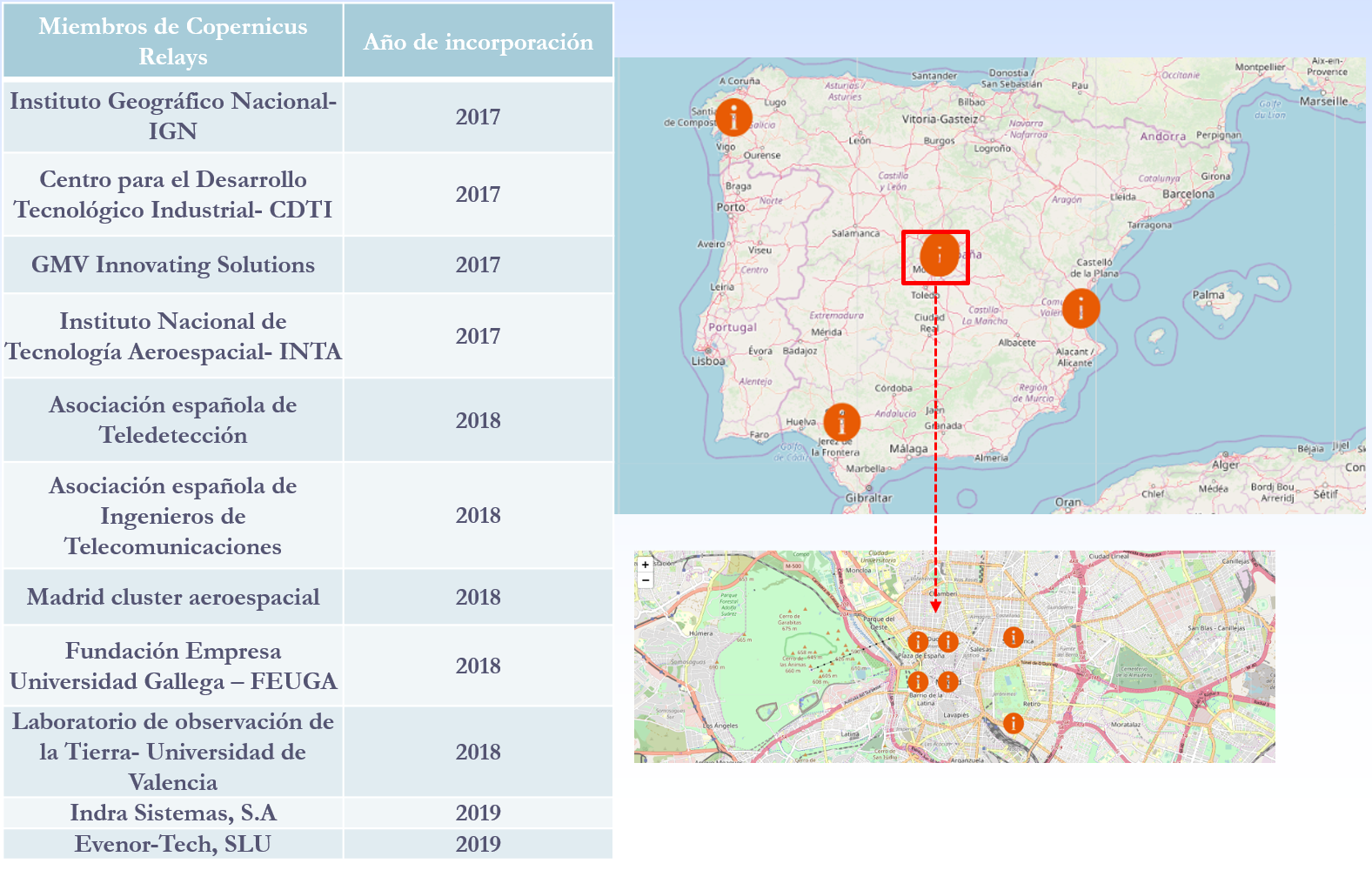
The Copernicus Relay are a group of organizations that coordinate and promote activities around the Copernicus program for local users and administrations in the field of Territory Observation. Its objective is to make known in Europe and outside Europe that Copernicus is a sustainable source of full, free and open information that meets the needs of national, regional and local public services, and that can function as a reinforcement for the development of services.
There are currently a total of 85 European Relay members of which 11 are Spanish. The IGN has been a member of Copernicus Relay since 2017.
The possible actions that can be developed by Copernicus Relay members are, among others:
- Coordinate activities at the local level
- Distribute Copernicus dissemination material.
- Inform about what Copernicus is and answer user questions.
- Perform and promote events to publicize Copernicus.
- Organize courses
Any organization that is well connected with user communities, such as private companies, research centers, universities and end users of the public or private sector, can participate. To be a member of Copernicus Relay it is necessary to make a request on this website.
- Copernicus Academy
The Copernicus Academy connect European universities, research institutions, business schools and private organizations of the countries participating in the program and beyond. The objective of the network is to link academic and research institutions with authorities and service providers, facilitating collaborative research and the development of conferences, training sessions and internships. It also provides educational and training material for researchers, scientists and entrepreneurs.
Copernicus Academy also works to increase ideas and good practices sharing across borders and disciplines, while contributing to the development of the use of Earth Observation data in general and Copernicus data and information in particular, in various organizations or industries of public or private users.
There are currently a total of 17 Academy members in Spain.
In short, through these and other initiatives it is expected that an increasing number of users will know the Copernicus program and boost the economic and social opportunities that it entails. Thanks to the accurate, up-to-date and easy-to-access information of the Copernicus program, we will be able to know our environment better, and make decisions that guarantee the future of all European and other regions citizens.
Content prepared based on information by Nuria Valcárcel, Deputy Assistant Director, D.G. National Geographic Institute. Ministry of development.
Evento
The new school year has already begun. While students are gradually returning to schools, companies and organizations are also recovering their activity. The last quarter of the year is chosen by a large number of organizations to launch events that help us to better understand the universe of open data, bringing us success stories and giving us the opportunity to discuss the future challenges.
In datos.gob.es we have compiled some of these events:
- On September 14, the Tech.Party 2019 is held at the Nave de Madrid. This event brings together more than 30 technological communities with the objective of “sharing knowledge and stimulating critical thinking”. Conferences and workshops will address issues such as blockchain technology, data analysis, artificial intelligence, hacktivism or technological recycling.
- Ten days later, on September 24, the #GIGAPP2019 Workshop: Civic applications and open data to supervise the power will be organized by Medialab Prado. This event will introduce recent Ibero-American experiences related to data opening for public accountability. Attendees will have the opportunity to share and discuss impressions with the creators of these tools.
- Meanwhile, the IV International Congress of Transparency will take place in Malaga from September 30 to October 2. The event will be structured in plenary sessions and seminars. Each seminar will act as a working group where different subjects will be discussed, including active advertising, open data and citizen participation.
- Cáceres will host, from October 23 to 25, the X Iberian Conference on Spatial Data Infrastructures (JIIDE 2019). Under the slogan "Local IDEs, bringing digital information to citizens", technical sessions, workshops and round tables will be held to share and publicize the Inspire Directive and the various activities carried out by local IDEs. Open data and e-administration will also be discussed.
- The Barcelona City Council has launched a new edition of the Barcelona Dades Obertes Challenge, a contest aimed at promoting knowledge and the use of open data in the educational centres of Barcelona. In addition, a new edition of the World Data Viz Challenge Barcelona_Kobe is also expected for the coming months.
- Two of the big conferences that every year close the autumn events season will also take place in the Catalan capital. We are talking about the IoT Solution world Congress and the Smart City Expo 2019. The first one will take place in October 29-31 and it will address blockchain, Artificial Intelligence, e-health and other issues where open data can have a great role. For its part, the Smart City Expo 2019 will be held from November 19 to 21. It will be a mandatory meeting for those interested in cities based on data, 5G and the future of connectivity.
All these events highlight the interest in data and open data in the business and social ecosystem. An interest that continues to grow year by year, with new editions of events already held and the incorporation of new appointments to the agenda, so that all those interested in the subject can continue learning.
Empresa reutilizadora
dotGIS is focused on the development of solutions and applications related to the management, integration and analysis of data with geospatial component.
Noticia
The Spatial Data Infrastructure of Spain (in Spanish ‘IDEE’) is an ambitious project to harmonize and merge the geographical data handled by all Spanish public administrations, as well as the current geographic information services. The final goal of the project is to make all these valuable data accessible through the Internet and with an integrated format that increases its usefulness.
Like any effort to integrate data, metadata or information services, the IDEE implicitly entails an important effort to complete and standardize data, and to make it accessible by complying not only with interoperability standards and technical protocols, but also with the corresponding legal frameworks. But, as often happens in this kind of situations, other initiatives can subsequently benefit from a series of positive externalities in the form of technological advances for the participants or improvements of the coordination processes.
The body in charge of coordinating the IDEE is the Ministry of Infrastructure through the High Geographic Council, which is a collegiate body in which all the producers of digital geographic data are represented. It is intended to be integrated in the three levels of government existing in Spain. The IDEE also collaborates with research teams from universities and public and private companies that work with geographic information technologies.
The Geographical High Council also acts as a point of contact with the European Commission for the implementation of the Inspire Directive (Infrastructure for Spatial Information in Europe) in Spain, which provides legal framework at European level. Inspire establishes the general rules for the establishment of a Spatial Information Infrastructure in the EU, with a clear environmental vocation and based on the compatible and interoperable infrastructures of the Member States. It also propose, since 2007, a model to encourage the opening and reuse of geographic data that has been used as an example for the promotion of open data policies in the public sector at European level, including the Directive on the reuse of information in the public sector.
Some of the benefits that have already been materialized as a result of the IDEE are the large geographic information production projects that we have described among the digital treasures of the National Geographic Institute, such as the National Aerial Orthophoto Plan (PNOA) or the Information System on Land Use of Spain (SIOSE).
In the IDEE geoportal, all data sets, metadata and geographic information services that are integrated into the project are published. The geoportal includes services such as a data catalog that allows locating and accessing different sets of data and metadata or a map viewer that allows even panoramic flights. Of course, the data sets are available not only for making an inquiry, but it is also possible, in most cases, to download them as open data for later reuse by interested users.
In the geoportal resources section of the IDEE there are also two sections that provide special added value beyond the datasets themselves:
- A collection of free tools of different nature useful for working with geographic data. Among the free tools we can find, for example, different map viewers that can be integrated into third-party web applications. These are data visualization apps based on maps that have been developed by different regional governments and have been made available to the public through an application programming interface (API) as part of their spatial data infrastructures (IDE). The section also highlights services such as the download of geographic objects asynchronously based on the Web Processing Service (WPS) standard, services for the transformation of coordinates or 3D viewers.
- The developer's corner, where we can find a set of reference documents for application developers that use geographic data sets. These documents have been created based on the Technical Guidelines for Network Services of the Inspire Directive and the specifications of the Open Geospatial Consortium (OGC). We can find for example a Guide to integrate WMS and WFS services in various applications or a technical guide related to the Visualization Service (WMS) or the Download Service (WFS 2.0.0). These documents are very useful for the development of visualization, download and localization services with different tools.
According to the Reusing Open Data report, elaborated by the European Data Portal, geographic data is the second data category most reused and consulted by companies in the member states of the European Union. Both in terms of data sets availability and harmonization, geographic data have a maturity degree that we still do not find in other sectors. In addition, we can say that, in terms of geographic information, Spain has not been limited to follow the trail of European legislation, whose deployment will not be completed until 2021, but has represented an example in its commitment and has gone beyond the minimum obligations imposed by Inspire.
Content prepared by Jose Luis Marín, Head of Corporate Technology Startegy en MADISON MK and Euroalert CEO.
Contents and points of view expressed in this publication are the exclusive responsibility of its author.
Noticia
The challenge
Aporta Challenge 2019 is an initiative promoted by datos.gob.es with the aim of identifying new ideas and prototypes based on open data, in order to help improve efficiency in strategic sectors for the Spanish economy, in this case, agri-food, forestry and rural sector. The Aporta Challenge drives the use and direct reuse of information generated by the public sector, encouraging participants’ talent, technical capacity and creativity. All the information about Aporta Challenge 2019 can be found at https://datos.gob.es/es/desafios-aporta.
Agri-food, forestry and rural sector data
When we look for that much-desired inspiration to find innovative and brilliant solutions for a certain sector, we immediately think of data. Having a wealth of data to represent the key processes of a sector is synonymous with success in the creation of disruptive and valuable solutions.
In particular, the agri-food, forestry and rural sectors cannot be characterized correctly without adequate data. It is not possible to think of innovative solutions for these sectors without maps, territory distribution by uses, aerial images (with drones or airplanes), satellite images, data from terrestrial sensors, weather forecasts, etc.
To participate in the Aporta Challenge, it is necessary to use at least one source of open data generated by Public Administrations, whether national or international, and published under an open license. It can be any type of data: INE statistics, meteorological data published by AEMET... but, if something characterizes many digital solutions for these sectors, it is the (almost) indivisible association between data and maps. Therefore, this time we are going to focus on this type of data -although others could be used- and the rest of the ingredients needed to obtain the perfect recipe for Aporta Challenge 2019:
- The use of Geographic Information System (GIS).
- Analytical tools such as programming languages and data science environments, APIs and connectors for data sources access.
- Visual data presentation and an adequate storytelling.
Geographic Information System (GIS)
The National Geographical Institute (IGN) is probably the best source of open geographic data in our country. In the IGN portal we can find validated and quality information in terms of geographic maps, PNOA (National Plan of Aerial Orthophotography) orthophotos and positioning services.
Intimately related to the IGN, the Ministry of Agriculture, Fisheries and Food offers the Agrarian Geographic Information System (SIGA) that shows cartographic and alphanumeric information, such as general cartography, thematic maps on agroclimatic variables or reports on municipalities and meteorological stations.
In addition, the website of the Ministry for Ecological Transition offers interesting data on maps. For example, the Ministry offers a service called Acuivisor to interactively explore the areas of mollusk production and aquaculture in Spain. In the same way, the Ministry offers citizens a Nature Data Bank where databases and thematic cartography can be found. Among many other open data, we can access to the Spanish forest map, which includes the distribution of Spanish forest stands since they began their first work a little over a hundred years ago.
For its part, the Spanish Meteorological Agency (AEMET) makes available to citizens, through its open data portal, all data related to weather forecast and climate data so that it is accessible and reusable by both people and applications in order to develop innovative solutions.
But not only geographical data feed solutions aimed at improving the efficiency of the agri-food, forestry and rural sector. In this report, recently published by datos.gob.es, you can find other repositories and resources that can help you to design your solution.
Data environments and programming languages
Once data sources have been selected, we must think about sources access, to extract the data of interest, and then carry out the corresponding analyses, something that will take place during Phase 2 of the Challenge.
In data science, there is an iterative process that consists of extracting, manipulating and transforming interesting data, and then modeling and communicating the result appropriately in the form of conclusions and valuable information. If we want to implement this process to create our prototype for Aporta Challenge 2019, here are some tips:
- Prototyping consists of failing fast and cheaply. Even if your team has the necessary programming skills, do not try to implement a complete (and therefore complex) solution based on data.
- If you are building a prototype, use prototyping tools. The first prototyping tool is to access and explore manually the potentially interesting data for our solution, either using our own tools (spreadsheets, map viewers, etc.) or the integrated utilities offered by data repositories.
- APIs and access to data repositories. We know that we can access to data offered in open and reusable standards in very different ways. We can use programs (access programmatically) and we can use tools such as Postman. Postman is a free product that has become a standard for accessing and testing APIs of all kinds. Postman allows you to extract data from any API easily and quickly. It is a great way to prototype.
- Tell a good story. Before moving forward with your prototype in the following complexity phases, ask yourself if with the data you have (and its corresponding analysis) you are able to communicate a good story. Sometimes we can have some fantastic data and analysis but, nevertheless, we are not able to tell a good story.
Your DataStory
Finally, if you have good data, these are accessible and reusable, and you have verified that you have a good story, you just need to implement your solution in a solid way and assemble your story. If your team has programming skills, it is sure that you will use R or Python as the main languages for data analysis. But do not stay there. Telling a good story goes far beyond programming and analysing data.
Telling a good story is about writing a good script (the storyline). Telling a good story is about falling in love and surprising the audience and, for that, you need good design and impressive images that reinforce the data message. If you are able to combine the presentation of your story with a functional application that shows the value of the data you use, you will have won. Telling your story through a web application such as Shiny will give you many points. If you prefer to emphasize the value of analyzing your data in a modern and current way, use notebooks like Jupyter and you will have assured success. If you need inspiration or go deeper into this concept of data-based stories (remember that maps play a special role in Aporta Challenge 2019) I recommend you visit the ESRI company's StoryMaps website and you can check the strength of a good story based on data and maps. In the post on Medium you will find a list of different types of tools to tell stories with data.
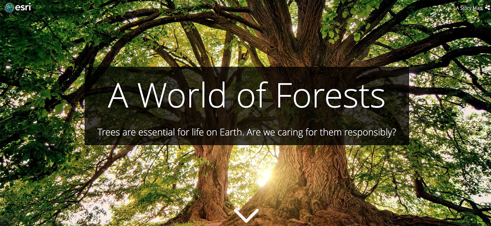
Example of StoryMap related to the theme of the Aporta Challenge 2019. https://storymaps.esri.com/stories/2019/anthropocene/3-forests/index.ht…;
Cheer up and go for Aporta Challenge 2019!
Content prepared by Alejandro Alija, expert in Digital Transformation and innovation.
Contents and points of view expressed in this publication are the exclusive responsibility of its author.
Noticia
Geographical data is the second data category most reused and consulted by EU companies, just behind statistical information. This statement, taken from Reusing Open Data, by the European Data Portal, highlights the high importance of geographic information in our society and economy.
In Spain, the official body that provides geographic data is the National Geographic Information Center, an autonomous body created in 1989 and assigned to the Ministry of Development through the National Geographic Institute (IGN). Among the functions of the National Geographic Information Center is the publication of the data produced by the IGN itself, guaranteeing its quality, as well as its reuse to create products and services that meet citizens’ demands.
The National Atlas of Spain, geography and history through cartographies
One of these services is National Atlas of Spain, which offers a synthetic and explanatory view of the geography, history and territorial organization of the country. To do so, it uses national cartographic representations, which are complemented with other communication resources such as graphics, texts, tables and charts, illustrations, photographs, satellite images or other multimedia resources.
This work has been compiled in España en mapas. Una síntesis geográfica, a volume with more than 600 pages and 800 maps. The document show from Roman settlements and roads, to the distribution of historic gardens or patents obtained. 150 scientists and researchers from 38 universities and research centers, as well as 120 Spanish public bodies and several international organizations have collaborated in its preparation.
The volume can be downloaded in digital format and for free, although it has also been published on paper. It should be noted that users can obtain the data, metadata and shapefile files associated from many of the maps in the CNIG Download Center as open data.
España en mapas was presented in the month of December and, in less than two months, it already had more than 14,000 downloads. The plan of the team is to update this work every 2 years.
Other applications to highlight
España en mapas joins other visualizations made by the IGN, many of which we already compiled in a previous article. However, there is more apps, such as Parques Nacionales, which allows you to consult information related to the history, fauna, flora and routes of all Spanish Natural Parks, including additional information on points of interest, such as information centers, accommodation, viewpoints, shelters, etc., or Mapas de España Básicos, ideal for hiking or other outdoor sports (cycling, running, skiing, etc.).
In addition, an increasing number of companies or citizens are using geographic data and IGN cartographies to develop their own solutions. This is the case of RuralMaps, an application that facilitates the management of emergencies by providing information through dynamic maps that evolve according to the land situation (floods, fires, etc.).
Developers can obtain data through the Download Center, which contains basic topographic data, such as transport networks, vector maps, flight orthophotos, digital elevations models, or even old geographic documentation. All this information can be used commercially, as long as the license requirements are met (CC BY 4.0 ign.es and CC BY 4.0 scne.es when data are co-produced by the IGN and other organizations).
In short, geographic data can be very useful for citizens, to better understand their environment, but they can also be a source of wealth and generation of new services and products through their reuse.
Noticia
Geographical data are highly relevant from the economic point of view. According to Reusing Open Data report, written by the European Data Portal, geographic data is the second most reused and consulted data category by companies in the member states of the European Union, only behind statistical information.
According to the UNE standard, when we speak of geographic data we refer to those data that implicitly or explicitly refer to a location relative to the Earth. This type of data can be published in open format, following a series of requirements.
Open geographical data allow us to better understand our environment, especially when they intersect with another type of sociocultural, economic or environmental information, - this is known as georeferenced data-. For this objective, there are different tools specialized in the integration, storage, edition, analysis or visualization of geographic data. This is the case of the Geographic Information Systems (GIS).
In Spain, the official cartography source that provides geographic data is the National Geographic Institute (IGN), a public body within the Ministry of Development that is responsible for measuring and collecting information from the land surface to make it available to users in different formats: official maps, cartographies, images, data files, web services and applications. In addition, the IGN shares free geographical datasets through its Download Center. This data can be reused, according to Order FOM / 2807/2015, to create multiple applications and services.
But there are other sources to obtain geographic data. For example, various regional and local organizations have also launched their geographic data initiatives, such as Aragón. The data shared by this autonomous community could be reused in projects such as Donde vivo, an application that allows users to know the services of a specific area of Aragón through an interactive map.
Precisely, due to its great re-use power, an increasing number of organisms have plans to share the geographic information under their custody. But before starting a project of this type, it is advisable to know what the challenges that can be found by users who want to reuse geographic data are, in order to solve them as soon as possible.
The report Roadblocks Hindering the Reuse of Open Geodata in Colombia and Spain includes an analysis of the barriers to facilitate the reuse of geographic data from the perspective of data consumers in Spain and Colombia. The report is based on 3 study sources: a review of the existing literature on the subject (articles, reports, conferences, presentations, etc.), an online questionnaire in Spanish, English and Portuguese, and a series of workshops held in four cities (Bogotá, Medellín, Cali and Valencia), with the participation of local authorities, user communities and experts in open data.
After the analysis of the results, the possible barriers identified by data users were classified into six groups: currency, accessibility, data quality; usability; discoverability and terms of use. However, these challenges can be solved. To this end, the report shares a series of recommendations:
- Identify data users group: the authorities responsible for geographic data initiatives need to involve users and reusers during the whole open data initiative, and not just at the last steep. That way, they can adjust their strategy to their needs. To do this, they can create working groups integrating different profiles from academic sector, business sector, public administration and civil society.
- Continuous services tracking: The continuous analysis and monitoring of the available services helps to solve the accessibility and data quality challenges. Some of the questions that those responsible for the initiatives must respond are: what the most requested services are, what services users want to download or what services need more accurate and complete metadata.
- Notification of further released data: Data producers can include notifications or automatic alerts that allow knowing the status of available services.
- Include clear and straightforward terms of use or license: The terms of use were mentioned for data users as one of the obstacles to reusing the current data in cities. Therefore, it is important to create a simple and specific set of terms with natural language will help to reduce any misunderstanding regarding the utilization allowed of the available data.
- Show examples of use or basic reuse kits: in order to improve usability, data users demand a greater number of examples and basic guidelines, as inspiration to encourage the use of data.
In short, geographic data can bring great benefits to society. This type of data has a great reuse power, since they can be integrated in different applications to enrich their services with georeferenced information. But to facilitate users to extract the maximum value from this data, it is advisable to take into account their needs from at the beginning of the initiative.
Empresa reutilizadora
Esri Spain is the distributor of ArcGIS Platform in Spain, a leader in Geographic Information Systems at an international level.
Noticia
In recent years, the opening of geographic data has allowed citizens and companies to better understand their environment, through maps and visualizations such as those included in the SignA portal of the National Geographic Institute or the digital Atlas of urban areas of the Ministry of Development. In addition, geographic data has also been reused by individuals and companies, who have dared to create from applications in order to know forest fires situation to strategy games, and many more applications.
The democratization of geographic datasets is becoming, therefore, increasingly evident. But there is not an official definition to facilitate standardization and data interoperability, which would further promote its publication and reuse. For this reason, the Spanish Association for Standardization (AENOR) has recently published Spanish Standard UNE 148004: 2018 "Open Geographic Data". This Standard was defined and approved by the Technical Standardization Committee 148 "Digital geographic information", after a process of public hearing, with the aim of providing a standardized definition of geographic open data that allows generating certification mechanisms.
Defining what is a geographic dataset was relatively easy. According to the text, geographic data are those "that implicitly or explicitly refer to an Earth´s location. However, defining open data is a little longer and more complex.
The open data explanation elaborated by CTN 148 is based on multiple sources, although one of its main pillars is the definition established by Open Knowledge International and published at http://opendefinition.org/. The Spanish Standard UNE 148004: 2018 enriches this definition based on 3 principles:
- Principle of barriers minimization: Data must be made available to citizens freely, avoiding any technical, administrative or legal barrier that prevents or limits their use.
- Principle of non-discrimination: Data access conditions must be equal for all users, without any privileges for particular user groups.
- Principle of technological neutrality: According to National Interoperability Scheme, described by RD 4/2010, of January 8, 2010, it is necessary to use open standards, which operate independently of the operating system and any communications or software layer. This helps to avoid users discrimination by technology - as the previous principle indicates-.
Once these principles are defined, the UNE 148004: 2018 Standard details what requirements open geographic data must meet. In accordance with the Standard, geographic data could be considered as “open” if they are:
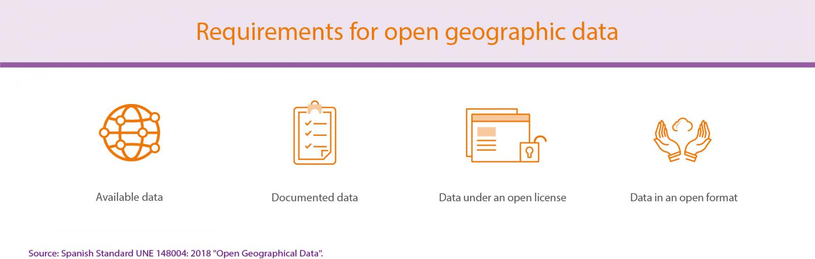
Below is a detail of each of these requirements:
- Available data: geographic open data must be available on the internet for total or partial download, free or at very low cost (with a price that covers the marginal cost of its preparation and publication).
- Documented data: it is essential to use descriptive metadata that facilitate data interpretation in a univocal way. These metadata should include information about language, coding system format, date of update and coordinate reference system (SRC).
- Data under an open license: open geographic data must be published under a standard open license, which has a clear, well-known public definition. This license implies its implicit acceptance with the mere download of the information, without discrimination. In addition, it must be non-revocable and universal, and must allow data exploitation, as a whole or in part, whatever the user's purpose.
- Data in an open format: geographic open data must be published in a digital format that allows the information to be processed automatically for its free use, irrevocably and without restrictions. In addition, it is important to include a complete technical description and, at least, one free software application would be able to process the complete standard. Finally, it is recommended that an open and participatory general interest organization approves the format.
The fact that these requirements facilitate to determine if a geographic dataset is open or not is a useful guide for all those public organizations that want to open this kind of information, facilitating standardization and interoperability. UNE 148004: 2018 "Open geographic data" is, therefore, a necessary standard. We hope it will promote the open geographic data publication and facilitate its exploitation and reuse.
Entrevista
Interview with Antonio F. Rodríguez Pascual, Assistant Deputy Director of CNIG.
-
What is the place of geospatial information within the general open data ecosystem?
To provide some figures, geographic information is inevitably present in seven (election results, national map, weather forecasts, pollutant emissions, location dataset, water quality, land ownership) of the thirteen essential datasets included in the Global Open Data Index of the Open Knowledge Foundation. It is also one of the types of information recognized as "highly important" by the Open Data Charter. According to the ASEDIE's report on the Infomediary Sector 2016, it is the third sector of the re-use market in terms of annual turnover, which represents a little more than 254 million euros, behind the Economic (20 %) and Market Research (27 %) industries. Without taking into account that the geospatial component is also present in two of the most relevant sectors: Market Research and Meteorological Information.
This type of information is considered one of the most important. It is necessary to reflect that, together with the statistical data, they are the best model of the real world that we have to make decisions, study problems, analyze phenomena, manage our resources, make plans and, in general, learn about the world.
It is a key epistemological tool. We always say that everything happens somewhere and it is true that, if we consider that indirect references, such as those defined by addresses, are also geographical, more than 80 % of the data managed by organizations are geographic data. Its importance has increased enormously with the almost permanent location of people through smart phones, the proliferation of sensors and georeferenced cameras and the development of the Internet of Things (IoT), which is already generating a sort of infosphere, a virtual space full of resources with coordinates that reflect and describe reality.
“More than 80 % of the data managed by organizations are geographic data.”
2. How has the European Directive INSPIRE helped the openness of geospatial data in Spain? At what point has this sector reached nowadays?
The implementation of the INSPIRE Directive in Europe and, especially, in Spain has contributed significantly to the openness of geospatial data. The European Commission has long recognized the synergy between the two activities. The fact is that in countries where the Inspire Directive is best established (Nordic countries, the Netherlands, the United Kingdom, Spain...) there are more open data and vice versa. This is probably due to the fact that the Inspire Directive has spread and promoted the idea that it is very positive to share geographic resources, both data and services, and this idea has spread to other sectors.
Especially in Spain, with the development of the Spatial Data Infrastructure of Spain (IDEE), whose motto is "If you share, you always gain more" (quote from "La buena suerte" by Álex Rovira and Trías de Bes, Uranus, 2004), the open data volume has increased significantly in recent years.
In a CNIG analysis made in 2016, from more than 100 Spanish pages of geographic information identified in which official geospatial data can be downloaded, 20 % of them offer partially open data (for non-commercial uses), 20 % closed data, 32 % offer completely open data and 36 % do not specify the use conditions, so we suspect that in a good number of cases the intention is also to publish open data and perhaps we can speak of at least 50 % of the offer of official geographic data.
Much progress has been made in the openness of geospatial data in Spain, but we are not completely satisfied, we have to progress even further. Antonio Gramsci said that "crises are those moments in which the old dies without the birth of the new" and I think that is the current situation in the area of Geomatics. There is an obsolete order based on desktop applications, the accumulation of data in silos as a capital to be profitable and monolithic power nuclei that do not just disappear and a new order that uses resources in the cloud, service-oriented architecture, open and networked organizations and new business models that have not been fully extended.
It is sharing with indirect benefits versus accumulating. A necessary change that points towards the information society, what the EU calls the Digital Single Market. The technicians are responsible for the technological revolutions to be produced at the desired rate and the collateral effects to be minimized.
According to the above mentioned ASEDIE’s report, the geospatial sector occupies the second place in the infomediary sector in terms of jobs generated, with 2,976 employees, 19 % of the sector, only behind the market studies, with 33 % with a light financial structure, since it has only 6 % (almost 18 million euros) of the subscribed capital by the sector and one of the lowest default risk.
And in the "Study of characterization of the infomediary sector of Spain" 2014, carried out by ONTSI, it is established that the geographic information sector is the most important within the re-use of public sector information, with 35 % of the companies, because urban planning information and meteorological forecast information are included.
3. According to your experience, what barriers hinder the openness and re-use of geospatial information in the public sector? What solutions do you propose to eliminate such obstacles?
It is a difficult question to answer, there is a wide variety of barriers and difficulties. First of all, I believe that there is a natural resistance to change, so to speak metaphorically our environment is full of boatmen who want to charge tolls who cross the bridges. But it is necessary to recognize that the changes of mentality are not easy and that the administration is moving in a short time from being considered part of the government that directs the society life to an actor who manages resources of all the citizens and is at their service; the data-producing agencies are evolving to become web service providers, they open up to collaborate with other public and private organizations... there are many changes described very well, for example, by Enrique Dans in "Everything is Changing" and Pekka Himanen in his book published in 2002, "The Ethics of the Hacker and the Spirit of the Information Age."
Secondly, there is also a lack of training in 2.0 web technologies, ISO 19100 standards, OGC standards and the applications that implement them, which is not easy to overcome in a short time. They are new technologies that involve complex formats and languages (UML, XML, GML ...), very specialized models and a new way of working.
“The data producing bodies are evolving to become web service providers, they open up to collaborate with other public and private organizations…”
Thirdly, it should be mentioned that the public administration is a machinery with considerable inertia, bureaucratic procedures that are sometimes very heavy and employees difficult to recycle. Finally, it should be mentioned that greater political support and commitment at the highest level would always be desirable.
As regards solutions to overcome these barriers, apart from the obvious ones, such as training courses, awareness events, implementation of electronic procedures, etc., all of them aspects in which a great effort is being made and Spain is well positioned (our country leads the European classifications of open data and e-government after the Brexit), we would like to mention two lines of action that seem to be particularly useful:
- Openness to the web. I think it is very positive for an administration to be present on the web and interact with its users through blogs, mailing lists, social networks and surveys. This allows us to learn about their concerns and needs, empathize with them and better meet their needs.
- Strategic planning. The experience we have had in implementing the Strategic Plan of IGN and CNIG has been excellent. It guides all human and physical resources, in the same direction; it establishes in a clear and participative way the vision, mission and objectives of the organization; it integrates and motivates the staff and defines a set of indicators to measure the greater or lesser success of the institution in an objective manner, taking into account that maximizing the economic benefit is not the end of the administration, but rather having the best possible investment/social impact rate and these variables are better evaluated if there is a Strategic Plan.
In summary, a Strategic Plan gives meaning to all the activities of an organization, directing them in the same direction and integrating the staff. It is a tool always recommended, but even more in paradigm change processes.
4. Nowadays, IGN is committed to publishing its data under the CC BY 4.0 license. To what extent do you consider essential the use of this type of license in the promotion of the data re-use?
The use of implicit licenses, which implies tacit acceptance, and standard licenses is essential because they enable license interoperability. Indeed, the alternative of having an own license defined in a text, which has to be written in one of the official languages in Spain, has the serious drawback that it compels users from countries whose official language is different (such as Germany, France, the United Kingdom, China, Japan, Korea and the Arab countries, for example) to tackle a series of difficult tasks if they want to use our data to georeference other information under another license, and create a value-added work with all legal guarantees: request a sworn translation into the language of the license text, an opinion that determines how the terms of the other license are mixed... While the Creative Commons 4.0 licenses are standard licenses internationally known and defined, which we already how to mix and hybridize with other type of licenses.
As for a license that only includes recognition, we believe that it is the most free and least restrictive license, since it focuses on the essential part of copyright, moral rights, without worrying about what the users may do with the data. In that sense, there are organizations that ask themselves what private companies are going to do with their data and if they are going to take advantage of the costs of generate them. The answer to this concern would be that everything they are going to do is positive for society: generating jobs, wealth and profit, paying taxes, disseminating data, giving them usefulness and meaning, spreading them, creating economic activity, and so on.
5. How has the data download policy at the National Geographic Information Center (CNIG) evolved in recent years, and what has the change meant for the Center?
In a first stage, which lasted almost 20 years, from 1989 to 2008, the CNIG commercialized the ING’s geographical data according to a price order, with discounts for research of up to 90 % and in line with data policies prevailing throughout Europe.
In a second phase, which began with the Ministerial Order FOM / 956/2008 and lasted seven years, until the end of 2015, the most important data products of the IGN (Geodesic Vertices, Limit Lines, Gazetteers and Population Databases) were defined as National Reference Geographic Equipment (EGRN) and established as open data. The remainder was defined as free data for non-commercial uses. In this way, IGN became the first official cartography producer in Europe to partially open up its data. However, this policy has been generating a very considerable increasing overhead, since more and more complicated use cases have been arising in which it was not trivial to elucidate whether or not there was commercial use.
Finally, in December 2015, the Ministerial Order FOM/2807/2015 was adopted, which defines all IGN data products and geographical services as open with the only condition for recognition, which has placed us among the most advanced countries of the world in the field of re-use and publication of open resources. Predictably, the aforementioned Global Open Data Index 2016, which will be published soon, will place Spain in the first place in the international classification of open geographic data along with other 11 countries.
“In 2015, the Ministerial Order FOM/2807/2015 was adopted, which defines all IGN data products and geographical services as open”
6. What point has the CNIG reached in opening up its information? What steps will the institution follow in terms of open data?
At first we believed that open data was a matter of free information, then we realized that the terms of use were more important (the license) and now we are aware that actually publishing open data means making a continuous and constant effort to minimize the barriers that hinder their use, something that of course involves gratuity and an open license, but it also includes a number of details, as it is reflected in the open knowledge definition by the Open Knowledge Foundation. As an example, we can mention that the option to download products in one run has more impact on the download number and volume in the CNIG than the new use license. The most important is to minimize barriers of all kinds and to progress in that line, what we will dedicate from now on.
"Publishing open data means a continuous and steady effort to minimize barriers that hinder their use"
We should also, as National Contact Point of the implementation of the INSPIRE Directive in Spain, go in-depth in the implementation of this directive and, of course, continue to collaborate with red.es in the integration of the national open geographical data in the data portal of our country.
In that sense, our next probable steps will be:
-Using a CC BY 4.0 license, once all the bureaucratic and administrative processes are completed.
-Progressing in the publication of information in open formats, this aspect still has to advance a lot in the field of geographical information where quite often the most effective, comfortable and widespread formats such as shapefile and ECW, for example, are not yet open formats.
- Formally defining a PSI Re-use Plan for IGN digital geographic data.
- Disseminating and promoting the publication of open data and services.
7. From your point of view, what are the main reasons that should encourage public administrations in Spain to open up their data?
We have identified up to ten good reasons to open up the data generated by the Public Administrations:
1) A question arise once a public body generates data with public resources, derived from citizens' taxes, and in the exercise of its functions, aimed ultimately at serving the needs of society: To what extent is it entitled to limit access to the data produced to those same citizens by invoking copyright?
2) Open data are beneficial to a country's economy, as shown by successive studies and analysis. As early as 2000, the well-known PIRA report, commissioned by the European Commission to conduct an extensive economic analysis of the exploitation of the Public Sector Information (PSI) sector in Europe, made an extensive comparison between USA and Europe, two very similar economies in size at that time. It concluded that each euro invested in the production of public geographic data in USA was translated into an increase of the ISP sector of approximately €44, while in Europe that increase was only about €8. One of the reasons for this difference was the fact that federal geographic data in USA were open, while in Europe they were completely closed. All the studies that we have already done on the same subject have confirmed these conclusions.
3) Several international initiatives directly related to economic development promote the adoption of open data policies as a clear growth and social benefit factor and underline the importance of geographic data as one of the priority types of information in this regard. To mention only three of them, the Open Data Charter led by the G-8 in 2013, the International Open Data Charter, supported by the G20 and the United Nations in 2015, and the Agenda 2030 for sustainable development, recommends open data, especially the geographical ones.
4) According to the experience of the CNIG during the last years, we can say that due to globalization, the democratization of cartography, the gratuity economy and the emergence of web services, revenues from commercial use licenses are less relevant. In 2015, total benefits accounted for only 8 % of the CNIG budget. It can be concluded in general terms that the commercialization of geographic data has long ceased to be a good business.
5) An open data policy allows an official geographic data producer to take advantage of the possibilities of Neocartography or Voluntary Geographic Information, because effectively how can voluntary citizens be motivated to collaborate in the collection and production of geographic data if, in the process, they must give up the ownership of some data that we then intend to sell them?
6) On the other hand, it allows the GeoInstitutes compete on equal and similar conditions, in terms of permitted uses and licenses, with other certainly popular actors who offer open geographical data and services or in quite open conditions, such as for example OpenStreetMap, which has an ODbL license similar to CC BY-SA, Geonames with its CC BY license or the Google Maps API and Carto services with their freemium business models, which offer free services to a certain number of queries if certain conditions are met.
7) If the official organisms that provide geographic data offer reference data, geographic data whose objective is to serve to georeference data of other subjects, it is logical that they promote their use in all type of applications and by all type of users, for which it seems clear that the best situation is spreading them as open data.
8) The experience of the IGN during the years in which it commercialized geographic data was that this information policy was a very important brake for the research, even though discounts up to 90 % were established for R&D uses, given the permanent scarcity of resources for this purpose. Many research papers were unfeasible, so open data are actually a stimulus to research, even promoting it.
9) It is a real social demand that, since some years, appears within the GI sector in some media and social networks. We should mention the campaign for the release of geographic data maintained by "The Guardian" in the United Kingdom and the appearance in London in 2004 of the OpenStreetMap phenomenon, among other reasons, in reaction to the closed data policy maintained by the Ordnance Survey. Curiously, this is one of the few demands in which both the right-wing party and the neo-liberals agree, requesting a light public sector at the service of the private sector, which transfer them their data, and the left-wing ones, who conceives an administration at the service of the citizen who provides with all the data it manages.
10) Finally, it should be noted that open data always generate very relevant intangible returns, the use of data in research projects and prestigious international initiatives, the improvement of corporate image, increased presence in the network and social networks, synergies with other sectors of application, and so on. And sometimes indirect benefits are not as intangible, as when opening up the data encourages the development of applications on them that are then useful for the data producer in their production processes.
All this, together with other reasons, makes it generally advisable for a producer of official geographical data to adopt an open data policy, although we also understand that in some cases there are public bodies that cannot do so because it is prevented by the legal framework in force or by their political and administrative situation, which forces them to self-finance in whole or in part, which makes inevitable that they try to obtain an economic return for the use of their data. In these cases, it must be remembered that, given the high cost of generating geographic data, the return obtained from marketing, taking into account the market prices, covers only a small part.
In summary and as I have already mentioned, I believe that technicians and public officials must be committed to progress and have the moral obligation to push technological revolutions to make them profitable, trying to minimize the adverse side effects that may occur.