Evento
Last September, the first edition of the European Data Spaces Awards was officially launched, an initiative promoted by the Data Spaces Support Centre (DSSC) in collaboration with the European Commission. These awards were created with the aim of promoting the best data exchange initiatives, recognizing their achievements and increasing their visibility. This seeks to promote good practices that can serve as a guide for other actors in the European data ecosystem. The idea is that the awards will be awarded annually, which will help the community grow and improve.
Why are these awards important?
Data is one of Europe's most valuable economic assets, and its strategic harnessing is critical for the development of technologies such as artificial intelligence (AI). Therefore, the European strategy It involves establishing a single market for data that allows innovation to be promoted effectively. However, at present, the data is still widely distributed among many actors in the European ecosystem.
The European Data Spaces Awards are especially relevant because they recognise and promote initiatives that help to overcome this problem: data spaces. These are organisational and technical environments where multiple actors – public and private – share data in a secure, sovereign, controlled way and in accordance with common standards that promote their interoperability. This allows data to flow across sectors and borders, driving innovation.
In Spain, the development of data spaces is also being promoted through specific initiatives such as the Plan to Promote Sectoral Data Spaces.
Two award categories
In this context, two categories of awards have been created:
- Excellence in end-user engagement and financial sustainability: Recognizes data spaces with a strong user focus and viable long-term financial models.
- Most innovative emerging data space: rewards new initiatives that bring fresh and innovative ideas with high impact on the European ecosystem.

Who can participate?
The European Data Spaces Awards are open to any data space that meets these criteria:
- Its governance authority is registered in the European Union.
- It operates wholly or partially within European territory.
- It is being actively used for data exchange.
- It includes restricted data, beyond open data.
Spaces in the implementation phase can also apply, as long as they share data in pilot or pre-operational environments. In these cases, the project coordinator can act on behalf of the project.
The assessment of eligibility will be based on the applicant's self-assessment, facilitating broad and representative participation of the European data ecosystem.
The same data space can apply for both categories, although you must make two different applications.
Schedule: registration open until November 7
The competition is structured in four key phases that set the pace of the participation and evaluation process:
- On 23 September 2025, the launch event was held and the application period was officially opened.
- The application submission phase will run for 7 weeks, until November 7, allowing data spaces to prepare and register their proposals.
- This will be followed by the evaluation phase, which will begin on December 17 and last 6 weeks. During this time, the Data Spaces Support Centre (DSSC) will conduct an internal eligibility review and the jury selects the winners.
- Finally, the awards will be announced and presented during the Data Space Symposium (DSS2026) event, on February 10 and 11, 2026 in Madrid. All nominees will be invited to take the stage during the ceremony, so they will get great visibility and recognition. The winners will not receive any monetary compensation.
How to participate?
To register, participants must access the online form available on the official website of the awards. This page provides all the resources needed to prepare for your application, including reference documents, templates, and updates on the process.
The form includes three required elements:
- Basic questions about the requester and the data space.
- The eligibility self-assessment with four mandatory questions.
- A space to upload the Awards Application Document, a document in PDF format and whose template is available on the platform. (maximum 8 pages). The document, which follows a structure aligned with the Maturity Model v2.0, details the objectives and evaluation criteria by section.
In addition, participants have a space to provide, optionally, links to additional resources that help give context to their proposal.
For any questions that may arise during the process, a support platform has been set up.
The European Data Spaces Awards 2025 not only recognise excellence, but also highlight the impact of projects that are transforming the future of data in Europe. If you are interested in participating, we invite you to read the complete rules of the competition on their website.
Blog
Artificial Intelligence (AI) is transforming society, the economy and public services at an unprecedented speed. This revolution brings enormous opportunities, but also challenges related to ethics, security and the protection of fundamental rights. Aware of this, the European Union approved the Artificial Intelligence Act (AI Act), in force since August 1, 2024, which establishes a harmonized and pioneering framework for the development, commercialization and use of AI systems in the single market, fostering innovation while protecting citizens.
A particularly relevant area of this regulation is general-purpose AI models (GPAI), such as large language models (LLMs) or multimodal models, which are trained on huge volumes of data from a wide variety of sources (text, images and video, audio and even user-generated data). This reality poses critical challenges in intellectual property, data protection and transparency on the origin and processing of information.
To address them, the European Commission, through the European AI Office, has published the Template for the Public Summary of Training Content for general-purpose AI models: a standardized format that providers will be required to complete and publish to summarize key information about the data used in training. From 2 August 2025, any general-purpose model placed on the market or distributed in the EU must be accompanied by this summary; models already on the market have until 2 August 2027 to adapt. This measure materializes the AI Act's principle of transparency and aims to shed light on the "black boxes" of AI.
In this article, we explain this template keys´s: from its objectives and structure, to information on deadlines, penalties, and next steps.
Objectives and relevance of the template
General-purpose AI models are trained on data from a wide variety of sources and modalities, such as:
-
Text: books, scientific articles, press, social networks.
-
Images and videos: digital content from the Internet and visual collections.
-
Audio: recordings, podcasts, radio programs, or conversations.
-
User data: information generated in interaction with the model itself or with other services of the provider.
This process of mass data collection is often opaque, raising concerns among rights holders, users, regulators, and society as a whole. Without transparency, it is difficult to assess whether data has been obtained lawfully, whether it includes unauthorised personal information or whether it adequately represents the cultural and linguistic diversity of the European Union.
Recital 107 of the AI Act states that the main objective of this template is to increase transparency and facilitate the exercise and protection of rights. Among the benefits it provides, the following stand out:
-
Intellectual property protection: allows authors, publishers and other rights holders to identify if their works have been used during training, facilitating the defense of their rights and a fair use of their content.
-
Privacy safeguard: helps detect whether personal data has been used, providing useful information so that affected individuals can exercise their rights under the General Data Protection Regulation (GDPR) and other regulations in the same field.
-
Prevention of bias and discrimination: provides information on the linguistic and cultural diversity of the sources used, key to assessing and mitigating biases that may lead to discrimination.
-
Fostering competition and research: reduces "black box" effects and facilitates academic scrutiny, while helping other companies better understand where data comes from, favoring more open and competitive markets.
In short, this template is not only a legal requirement, but a tool to build trust in artificial intelligence, creating an ecosystem in which technological innovation and the protection of rights are mutually reinforcing.
Template structure
The template, officially published on 24 July 2025 after a public consultation with more than 430 participating organisations, has been designed so that the information is presented in a clear, homogeneous and understandable way, both for specialists and for the public.
It consists of three main sections, ranging from basic model identification to legal aspects related to data processing.
1. General information
It provides a global view of the provider, the model, and the general characteristics of the training data:
-
Identification of the supplier, such as name and contact details.
-
Identification of the model and its versions, including dependencies if it is a modification (fine-tuning) of another model.
-
Date of placing the model on the market in the EU.
-
Data modalities used (text, image, audio, video, or others).
-
Approximate size of data by modality, expressed in wide ranges (e.g., less than 1 billion tokens, between 1 billion and 10 trillion, more than 10 trillion).
-
Language coverage, with special attention to the official languages of the European Union.
This section provides a level of detail sufficient to understand the extent and nature of the training, without revealing trade secrets.
2. List of data sources
It is the core of the template, where the origin of the training data is detailed. It is organized into six main categories, plus a residual category (other).
-
Public datasets:
-
Data that is freely available and downloadable as a whole or in blocks (e.g., open data portals, common crawl, scholarly repositories).
-
"Large" sets must be identified, defined as those that represent more than 3% of the total public data used in a specific modality.
-
-
Licensed private sets:
-
Data obtained through commercial agreements with rights holders or their representatives, such as licenses with publishers for the use of digital books.
-
A general description is provided only.
-
-
Other unlicensed private data:
-
Databases acquired from third parties that do not directly manage copyright.
-
If they are publicly known, they must be listed; otherwise, a general description (data type, nature, languages) is sufficient.
-
-
Data obtained through web crawling/scraping:
-
Information collected by or on behalf of the supplier using automated tools.
-
It must be specified:
-
Name/identifier of the trackers.
-
Purpose and behavior (respect for robots.txt, captchas, paywalls, etc.).
-
Collection period.
-
Types of websites (media, social networks, blogs, public portals, etc.).
-
List of most relevant domains, covering at least the top 10% by volume. For SMBs, this requirement is adjusted to 5% or a maximum of 1,000 domains, whichever is less.
-
-
-
Users data:
-
Information generated through interaction with the model or with other provider services.
-
It must indicate which services contribute and the modality of the data (text, image, audio, etc.).
-
-
Synthetic data:
-
Data created by or for the supplier using other AI models (e.g., model distillation or reinforcement with human feedback - RLHF).
-
Where appropriate, the generator model should be identified if it is available in the market.
-
Additional category – Other: Includes data that does not fit into the above categories, such as offline sources, self-digitization, manual tagging, or human generation.
3. Aspects of data processing
It focuses on how data has been handled before and during training, with a particular focus on legal compliance:
-
Respect for Text and Data Mining (TDM): measures taken to honour the right of exclusion provided for in Article 4(3) of Directive 2019/790 on copyright, which allows rightholders to prevent the mining of texts and data. This right is exercised through opt-out protocols, such as tags in files or configurations in robots.txt, that indicate that certain content cannot be used to train models. Vendors should explain how they have identified and respected these opt-outs in their own datasets and in those purchased from third parties.
-
Removal of illegal content: procedures used to prevent or debug content that is illegal under EU law, such as child sexual abuse material, terrorist content or serious intellectual property infringements. These mechanisms may include blacklisting, automatic classifiers, or human review, but without revealing trade secrets.
The following diagram summarizes these three sections:

Balancing transparency and trade secrets
The European Commission has designed the template seeking a delicate balance: offering sufficient information to protect rights and promote transparency, without forcing the disclosure of information that could compromise the competitiveness of suppliers.
-
Public sources: the highest level of detail is required, including names and links to "large" datasets.
-
Private sources: a more limited level of detail is allowed, through general descriptions when the information is not public.
-
Web scraping: a summary list of domains is required, without the need to detail exact combinations.
-
User and synthetic data: the information is limited to confirming its use and describing the modality.
Thanks to this approach, the summary is "generally complete" in scope, but not "technically detailed", protecting both transparency and the intellectual and commercial property of companies.
Compliance, deadlines and penalties
Article 53 of the AI Act details the obligations of general-purpose model providers, most notably the publication of this summary of training data.
This obligation is complemented by other measures, such as:
-
Have a public copyright policy.
-
Implement risk assessment and mitigation processes, especially for models that may generate systemic risks.
-
Establish mechanisms for traceability and supervision of data and training processes.
Non-compliance can lead to significant fines, up to €15 million or 3% of the company's annual global turnover, whichever is higher.
Next Steps for Suppliers
To adapt to this new obligation, providers should:
-
Review internal data collection and management processes to ensure that necessary information is available and verifiable.
-
Establish clear transparency and copyright policies, including protocols to respect the right of exclusion in text and data mining (TDM).
-
Publish the abstract on official channels before the corresponding deadline.
-
Update the summary periodically, at least every six months or when there are material changes in training.
The European Commission, through the European AI Office, will monitor compliance and may request corrections or impose sanctions.
A key tool for governing data
In our previous article, "Governing Data to Govern Artificial Intelligence", we highlighted that reliable AI is only possible if there is a solid governance of data.
This new template reinforces that principle, offering a standardized mechanism for describing the lifecycle of data, from source to processing, and encouraging interoperability and responsible reuse.
This is a decisive step towards a more transparent, fair and aligned AI with European values, where the protection of rights and technological innovation can advance together.
Conclusions
The publication of the Public Summary Template marks a historic milestone in the regulation of AI in Europe. By requiring providers to document and make public the data used in training, the European Union is taking a decisive step towards a more transparent and trustworthy artificial intelligence, based on responsibility and respect for fundamental rights. In a world where data is the engine of innovation, this tool becomes the key to governing data before governing AI, ensuring that technological development is built on trust and ethics.
Content created by Dr. Fernando Gualo, Professor at UCLM and Government and Data Quality Consultant. The content and views expressed in this publication are the sole responsibility of the author.
Blog
To achieve its environmental sustainability goals, Europe needs accurate, accessible and up-to-date information that enables evidence-based decision-making. The Green Deal Data Space (GDDS) will facilitate this transformation by integrating diverse data sources into a common, interoperable and open digital infrastructure.
In Europe, work is being done on its development through various projects, which have made it possible to obtain recommendations and good practices for its implementation. Discover them in this article!
What is the Green Deal Data Space?
The Green Deal Data Space (GDDS) is an initiative of the European Commission to create a digital ecosystem that brings together data from multiple sectors. It aims to support and accelerate the objectives of the Green Deal: the European Union's roadmap for a sustainable, climate-neutral and fair economy. The pillars of the Green Deal include:
- An energy transition that reduces emissions and improves efficiency.
- The promotion of the circular economy, promoting the recycling, reuse and repair of products to minimise waste.
- The promotion of more sustainable agricultural practices.
- Restoring nature and biodiversity, protecting natural habitats and reducing air, water and soil pollution.
- The guarantee of social justice, through a transition that makes it easier for no country or community to be left behind.
Through this comprehensive strategy, the EU aims to become the world's first competitive and resource-efficient economy, achieving net-zero greenhouse gas emissions by 2050. The Green Deal Data Space is positioned as a key tool to achieve these objectives. Integrated into the European Data Strategy, data spaces are digital environments that enable the reliable exchange of data, while maintaining sovereignty and ensuring trust and security under a set of mutually agreed rules.
In this specific case, the GDDS will integrate valuable data on biodiversity, zero pollution, circular economy, climate change, forest services, smart mobility and environmental compliance. This data will be easy to locate, interoperable, accessible and reusable under the FAIR (Findability, Accessibility, Interoperability, Reusability) principles.
The GDDS will be implemented through the SAGE (Dataspace for a Green and Sustainable Europe) project and will be based on the results of the GREAT (Governance of Responsible Innovation) initiative.
A report with recommendations for the GDDS
How we saw in a previous article, four pioneering projects are laying the foundations for this ecosystem: AD4GD, B-Cubed, FAIRiCUBE and USAGE. These projects, funded under the HORIZON call, have analysed and documented for several years the requirements necessary to ensure that the GDDS follows the FAIR principles. As a result of this work, the report "Policy Brief: Unlocking The Full Potential Of The Green Deal Data Space”. It is a set of recommendations that seek to serve as a guide to the successful implementation of the Green Deal Data Space.
The report highlights five major areas in which the challenges of GDDS construction are concentrated:
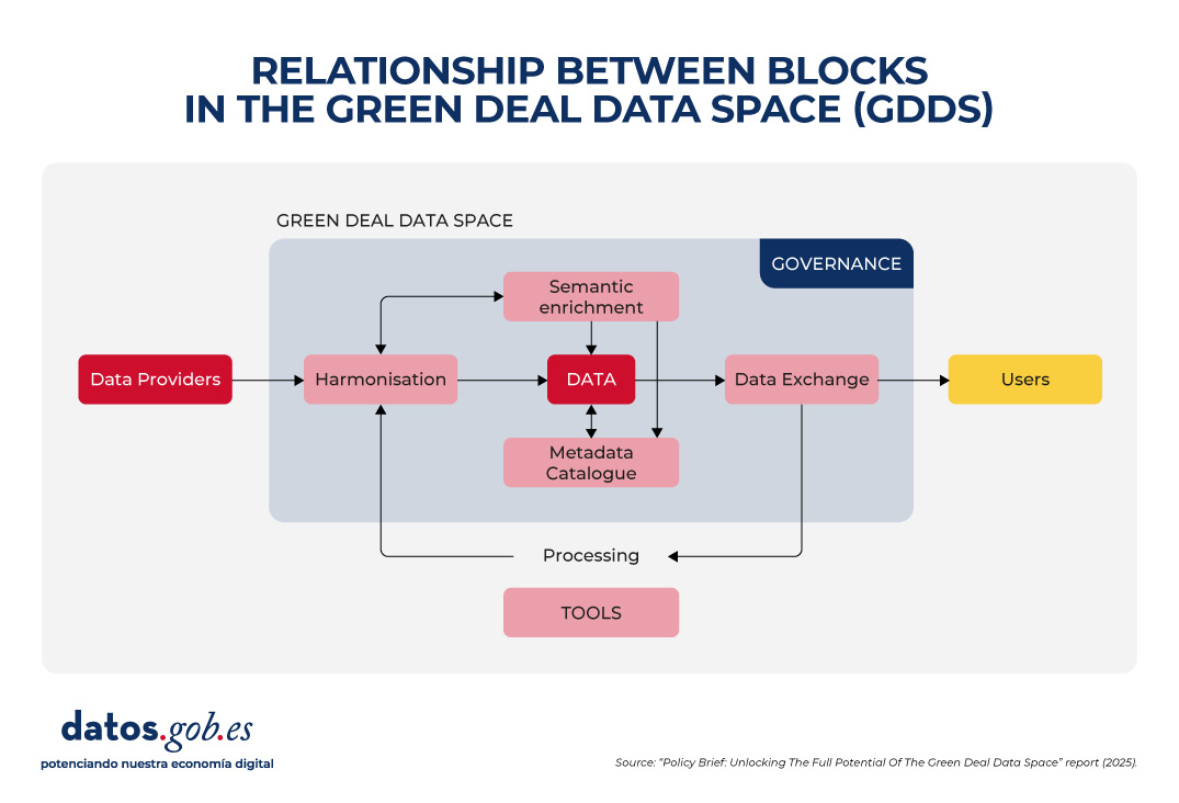
1. Data harmonization
Environmental data is heterogeneous, as it comes from different sources: satellites, sensors, weather stations, biodiversity registers, private companies, research institutes, etc. Each provider uses its own formats, scales, and methodologies. This causes incompatibilities that make it difficult to compare and combine data. To fix this, it is essential to:
- Adopt existing international standards and vocabularies, such as INSPIRE, that span multiple subject areas.
- Avoid proprietary formats, prioritizing those that are open and well documented.
- Invest in tools that allow data to be easily transformed from one format to another.
2. Semantic interoperability
Ensuring semantic interoperability is crucial so that data can be understood and reused across different contexts and disciplines, which is critical when sharing data between communities as diverse as those participating in the Green Deal objectives. In addition, the Data Act requires participants in data spaces to provide machine-readable descriptions of datasets, thus ensuring their location, access, and reuse. In addition, it requires that the vocabularies, taxonomies and lists of codes used be documented in a public and coherent manner. To achieve this, it is necessary to:
- Use linked data and metadata that offer clear and shared concepts, through vocabularies, ontologies and standards such as those developed by the OGC or ISO standards.
- Use existing standards to organize and describe data and only create new extensions when really necessary.
- Improve the already accepted international vocabularies, giving them more precision and taking advantage of the fact that they are already widely used by scientific communities.
3. Metadata and data curation
Data only reaches its maximum value if it is accompanied by clear metadata explaining its origin, quality, restrictions on use and access conditions. However, poor metadata management remains a major barrier. In many cases, metadata is non-existent, incomplete, or poorly structured, and is often lost when translated between non-interoperable standards. To improve this situation, it is necessary to:
- Extend existing metadata standards to include critical elements such as observations, measurements, source traceability, etc.
- Foster interoperability between metadata standards in use, through mapping and transformation tools that respond to both commercial and open data needs.
- Recognize and finance the creation and maintenance of metadata in European projects, incorporating the obligation to generate a standardized catalogue from the outset in data management plans.
4. Data Exchange and Federated Provisioning
The GDDS does not only seek to centralize all the information in a single repository, but also to allow multiple actors to share data in a federated and secure way. Therefore, it is necessary to strike a balance between open access and the protection of rights and privacy. This requires:
- Adopt and promote open and easy-to-use technologies that allow the integration between open and protected data, complying with the General Data Protection Regulation (GDPR).
- Ensure the integration of various APIs used by data providers and user communities, accompanied by clear demonstrators and guidelines. However, the use of standardized APIs needs to be promoted to facilitate a smoother implementation, such as OGC (Open Geospatial Consortium) APIs for geospatial assets.
- Offer clear specification and conversion tools to enable interoperability between APIs and data formats.
In parallel to the development of the Eclipse Dataspace Connectors (an open-source technology to facilitate the creation of data spaces), it is proposed to explore alternatives such as blockchain catalogs or digital certificates, following examples such as the FACTS (Federated Agile Collaborative Trusted System).
5. Inclusive and sustainable governance
The success of the GDDS will depend on establishing a robust governance framework that ensures transparency, participation, and long-term sustainability. It is not only about technical standards, but also about fair and representative rules. To make progress in this regard, it is key to:
- Use only European clouds to ensure data sovereignty, strengthen security and comply with EU regulations, something that is especially important in the face of today's global challenges.
- Integrating open platforms such as Copernicus, the European Data Portal and INSPIRE into the GDDS strengthens interoperability and facilitates access to public data. In this regard, it is necessary to design effective strategies to attract open data providers and prevent GDDS from becoming a commercial or restricted environment.
- Mandating data in publicly funded academic journals increases its visibility, and supporting standardization initiatives strengthens the visibility of data and ensures its long-term maintenance.
- Providing comprehensive training and promoting cross-use of harmonization tools prevents the creation of new data silos and improves cross-domain collaboration.
The following image summarizes the relationship between these blocks:
Conclusion
All these recommendations have an impact on a central idea: building a Green Deal Data Space that complies with the FAIR principles is not only a technical issue, but also a strategic and ethical one. It requires cross-sector collaboration, political commitment, investment in capacities, and inclusive governance that ensures equity and sustainability. If Europe succeeds in consolidating this digital ecosystem, it will be better prepared to meet environmental challenges with informed, transparent and common good-oriented decisions.
Blog
In an increasingly complex world, public decisions need more than intuition: they require scientific evidence. This is where I+P (Innovation + Public Policy) initiatives come into play: an intersection between creativity, data-driven knowledge, and policy action.
In this article we will explain this concept, including examples and information about funding programs.
What is I+P?
I+P is not a mathematical formula, but a strategic practice that combines scientific knowledge, research, and citizen participation to improve the formulation, implementation, and evaluation of public policies. It is not only a matter of applying technology to the public sphere, but of rethinking how decisions are made, how solutions are formulated and how society is involved in these processes through the application of scientific methodologies.
This idea stems from the concept of "science for public policy", also known as "science for policy" or "Science for Policy" (S4P) and implies active collaboration between public administrations and the scientific community.
I+P initiatives promote empirical evidence and experimentation. To this end, they promote the use of data, emerging technologies, pilot tests, agile methodologies and feedback loops that help design more efficient and effective policies, focused on the real needs of citizens. This facilitates real-time decision-making and the possibility of making agile adjustments in situations that require quick responses. In short, it is about providing more creative and accurate responses to today's challenges, such as climate change or digital inequality, areas where traditional policies can fall short.
The following visual summarizes these and other benefits.
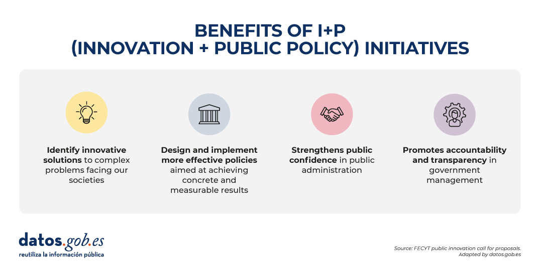
Source: FECYT Call for Public Innovation - adapted by datos.gob.es.
Examples of R+P initiatives
The use of data for political decision-making was evident during the COVID-19 pandemic, where policymakers were adapting the measures to be taken based on reports from institutions such as the World Health Organization (WHO). But beyond these types of extraordinary events, today we find consolidated initiatives that increasingly seek to promote innovation and decision-making based on scientific data in the public sphere on an ongoing basis. Let's look at two examples.
-
Periodic reports from scientific institutions to bring scientific knowledge closer to public decision-making
Scientific reports on topics such as climate change, bacterial resistance or food production are examples of how science can guide informed policy decisions.
The Science4Policy initiative of the Spanish National Research Council (CSIC) is an example of this. It is a collection of thematic reports that present solid evidence, generated in its research centers, on relevant social problems. Each report includes:
- An introduction to the problem and its social impact.
- Information on the research carried out by the CSIC on the subject.
- Conclusions and recommendations for public policies.
Its main objective is to transform scientific knowledge into accessible contributions for non-specialized audiences, thus facilitating informed decisions by public authorities.
-
Public innovation laboratories, a space for science-based creativity
Public innovation labs or GovLabs are experimental spaces that allow public employees, scientists, experts in various fields and citizens to co-create policies, prototype solutions and learn iteratively.
An example is the Public Innovation Laboratory (LIP) promoted by the National Institute of Public Administration (INAP), where pilots have been carried out on the use of technologies to promote the new generation of jobs, intermunicipal collaboration to share talent or the decentralization of selective tests. In addition, they have an Innovation Resources Catalogue where tools with open licences launched by various organisations are compiled and can be used to support public entrepreneurs.
It is also worth highlighting the Spanish Network for Public Innovation and Scientific Transfer, promoted by the NovaGob Foundation. It is a collaborative space that brings together professionals, public administrations, universities and third sector organisations with the aim of transforming public management in Spain. Through working groups and repositories of good practices, it promotes the use of artificial intelligence, administrative simplification and the improvement of citizen service.
We also find public innovation laboratories at the regional level, such as Govtechlab Madrid, a project led by the madri+d Foundation for Knowledge that connects startups and digital SMEs with public institutions to solve real challenges. During the 2023/2024 academic year, they launched 9 pilots, for example, to collect and analyse the opinion of citizens to make better decisions in the Alcobendas City Council, unify the collection and management of data in the registrations of the activities of the Youth Area of the Boadilla del Monte City Council or provide truthful and updated information digitally on the commercial fabric of Mostoles.
The role of governments and public institutions
Innovation in public policy can be driven by a diversity of actors: public administrations open to change, universities and research centres, civic startups and technology companies, civil society organisations or committed citizens.
The European Commission, for example, plays a key role in strengthening the science-for-policy ecosystem in Europe, promoting the effective use of scientific knowledge in decision-making at all levels: European, national, regional and local. Through programmes such as Horizon Europe and the European Research Area Policy Agenda 2025-2027, actions are promoted to develop capacities, share good practices and align research with societal needs.
In Spain we also find actions such as the recent call for funding from the Spanish Foundation for Science and Technology (FECYT), the Ministry of Science, Innovation and Universities, and the National Office of Scientific Advice, whose objective is to promote:
- Research projects that generate new scientific evidence applicable to the design of public policies (Category A).
- Scientific advice and knowledge transfer activities between researchers and public officials (Category B).
Projects can receive up to €100,000 (Category A) or €25,000 (Category B), covering up to 90% of the total cost. Research organizations, universities, health entities, technology centers, R+D centers and other actors that promote the transfer of R+D can participate. The deadline to apply for the aid ends on September 17, 2025. For more information, you should visit the rules of the call or attend some training sessions that are being held.
Conclusion
In a world where social, economic and environmental challenges are increasingly complex, we need new ways of thinking and acting from public institutions. For this reason, R+P is not a fad, it is a necessity that allows us to move from "we think it works" to "we know it works", promoting a more adaptive, agile and effective policy.
Blog
In an increasingly digitised world, the creation, use and distribution of software and data have become essential activities for individuals, businesses and government organisations. However, behind these everyday practices lies a crucial aspect: licensingof both software and data.
Understanding what licences are, their types and their importance is essential to ensure legal and ethical use of digital resources. In this article, we will explore these concepts in a simple and accessible way, as well as discuss a valuable tool called Joinup Licensing Assistant, developed by the European Union.
What are licences and why are they important?
A licence is a legal agreement that grants specific permissions on the use of a digital product, be it software, data, multimedia content or other resources. This agreement sets out the conditions under which the product may be used, modified, distributed or marketed. Licences are essential because they protect the rights of creators, ensure that users understand their rights and obligations, and foster a safe and collaborative digital environment.
The following are some examples of the most popular ones, both for data and software.
Common types of licences
Copyright
Copyright is an automatic protection which arises at the moment of the creation of an original work, be it literary, artistic or scientific. It is not necessary to formally register the work in order for it to be protected by copyright. This right grants the creator exclusive rights over the reproduction, distribution, public communication and transformation of his work.
Ejemplo: When a company creates a dataset on, for example, construction trends, it automatically owns the copyright on that data. This means that others may not use, modify or distribute such data without the explicit permission of the creator.
Public domain
When a work is not protected by copyright, it is considered to be in the public domain. This may occur because the rights have expired, the author has waived them or because the work does not meet the legal requirements for protection. For example, a work that lacks sufficient originality - such as a telephone list or a standard form - does not qualify for protection. Works in the public domain may be used freely by anyone, without the need to obtain permission.
Ejemplo: Many classic works of literature, such as those of William Shakespeare, are in the public domain and can be freely reproduced and adapted.
Creative commons
The Creative Commons licences offer aflexible way to grant permissions for the use of copyrighted works. These licences allow creators to specify which uses they do and do not allow, facilitating the dissemination and re-use of their works under clear conditions. The most common CC licences include:
-
CC BY (Attribution): permits the use, distribution and creation of derivative works, provided credit is given to the original author.
-
CC BY-SA (Attribution-Share Alike): in addition to attribution, requires that derivative works be distributed under the same licence.
-
CC BY-ND (Attribution-No Derivative Works): permits redistribution, commercial and non-commercial, provided the work remains intact and credit is given to the author.
- CC0 (Public Domain): allows creators to waive all rights to their works, allowing them to be used freely without attribution.
These licences are especially useful for creators who wish to share their works while retaining certain rights over their use.
GNU General Public License (GPL)
The GNU General Public License (GPL) , created by the Free Software Foundation, guarantees that software licensed under its terms will always remain free and accessible to everyone. This licence is specifically designed for software, not data. It aims to ensure that the software remains free, accessible and modifiable by any user, protecting the freedoms related to its use and distribution.
This licence not only allows users to use, modify and distribute the software, but also requires that any derivative works retain the same terms of freedom. In other words, any software that is distributed or modified under the GPL must remain free for all its users. The GPL is designed to protect four essential freedoms:
- The freedom to use the software for any purpose.
- The freedom to study how the software works and adapt it to specific needs.
- The freedom to distribute copies of the software to help others.
- The freedom to improve the software and release the improvements for the benefit of the community.
One of the key features of the GPL is its "copyleft" clause, which requires that any derivative works be licensed under the same terms as the original software. This prevents free software from becoming proprietary and ensures that the original freedoms remain intact.
Ejemplo: Suppose a company develops a programme under the GPL and distributes it to its customers. If any of these customers decide to modify the source code to suit their needs, it is their right to do so. In addition, if the company or customer wishes to redistribute modified versions of the software, they must do so under the same GPL licence, ensuring that any new user also enjoys the original freedoms.
European Union Public Licence (EUPL)
The European Union Public License (EUPL) is a free and open source software licence developed by the European Commission. Designed to facilitate interoperability and cooperation between Europeansoftware, the EUPL allows the free use, modification and distribution of software, ensuring that derivative works are also kept open. In addition to covering software, the EUPL can be applied to ancillary documents such as specifications, user manuals and technical documentation.
Although the EUPL is used for software, in some cases it may be applicable to datasets or content (such as text, graphics, images, documentation or any other material not considered software or structured data),but its use in open data is less common than other specific licences such as Creative Commons or Open Data Commons.
Open Data Commons (ODC-BY)
The Open Data Commons Attribution License (ODC-BY) is a licence designed specifically for databases and datasets, developed by the Open Knowledge Foundation. It aims to allow free use of data, while requiring appropriate acknowledgement of the original creator. This licence is not designed for software, but for structured data, such as statistics, open catalogues or geospatial maps.
ODC-BY allows users to:
- Copy, Distribute and use the database.
- Create derivative works, such as visualisations, analyses or derivative products.
- Adapt data to new needs or combine them with other sources.
The only main condition is attribution: users must credit the original creator appropriately, including clear references to the source.
A notable feature of the ODC-BY is that does not impose a copyleft clause, meaning that derived data can be licensed under other terms, as long as attribution is maintained.
Ejemplo: Imagine that a city publishes its bicycle station database under ODC-BY. A company can download this data, create an app that recommends cycling routes and add new layers of information. As long as you clearly indicate that the original data comes from the municipality, you can offer your app under any licence you wish, even on a commercial basis.
A comparison of these most commonly used licences allows us to better understand their differences:
|
Licence |
Allows commercial use |
Permitted modification |
Requires attribution | Allos derivative works | Applicable to data | Specialisationsnn |
|
Copyright |
Yes, with permission of the author | No, except by agreement with the creator | No | No | It can be applied to databases, but only if they meet certain requirements of creativity and originality in their structure or selection of content. It does not protect the data itself, but the way it is organised or presented. | Original works such as texts, music, films, software and, in some cases, databases whose structure or selection is creative. It does not protect the data itself. |
| Public domain | Yes | Yes | No | Yes | Yes | Original works such as texts, music, films and software without copyright protection (by expiration, waiver, or legal exclusion) |
| Creative Commons BY (Attribution) | Yes | Yes, with attribution | Yes | Yes | Yes | Reusable text, images, videos, infographics, web content and datasets, provided that authorship is acknowledged |
| Creative Commons BY-SA (Attribution-ShareAlike) | Yes | Yes, you must keep the same licence | Yes | Yes, with the same licence | Yes | Collaborative content such as articles, maps, datasets or open educational resources; ideal for community projects |
| Creative Commons BY-ND (Attribution-NoDerivatives) | Yes | No | Yes | No | Yes, but it is forbidden to modify or combine the data. | Content to be preserved unaltered: official documents, closed infographics, unalterable data sets, etc. |
| Creative Commons CC0 (Public domain) | Yes | Yes | No | Yes | Yes | All kinds of works: texts, images, music, data, software, etc., which are voluntarily released into the public domain. |
| GNU General Public License (GPL) | Yes | Yes, it should be kept under the GPL | Yes | Yes | No | Executable software or source code. Not suitable for documentation, multimedia content or databases. |
| European Union Public Licence (EUPL) | Yes | Yes, derivative works should remain open | Yes | Yes | Partially: could be used for technical data, but is not its main purpose | Software developed by public administrations and its associated technical documentation (manuals, specifications, etc.). |
| Open Data Commons (ODC-BY) | Yes | Yes | Yes | Yes | Yes (specifically designed for open data) | Structured databases such as public statistics, geospatial arrays, open catalogues or administrative registers |
Figure 1. Comparative table. Source: own elaboration
Why is it necessary to use licences in the field of open data?
In the field of open data, these licences are essential to ensure that data is available for public use, promoting transparency, innovation and the development of data-driven solutions. In general, the advantages of using clear licences are:
-
Transparency and open access: clear licences allow citizens, researchers and developers to access and use public data without undue restrictions, fostering government transparency and accountability.
-
Fostering innovation: By enabling the free use of data, open data licences facilitate the creation of applications, services and analytics that can generate economic and social value.
-
Collaboration and reuse: licences that allow for the reuse and modification of data encourage collaboration between different entities and disciplines, fostering the development of more robust and complete solutions.
-
Improved data quality: The availability of open data encourages greater community participation and review, which can lead to an improvement in the quality and accuracy of the data available.
-
Legal certainty for the re-user: Clear licences provide confidence and certainty to those who re-use data, as they know they can do so legally and without fear of future conflicts.
Introduction to the Joinup Licensing Assistant?
In this complex licensing landscape, choosing the right one can be a daunting task, especially for those with no previous experience in licence management. This is where the Joinup Licensing Assistant, a tool developed by the European Union and available at Joinup.europa.eu, comes in. This collaborative platform is designed to promote the exchange of solutions and best practices between public administrations, companies and citizens, and the Licensing Assistant is one of its star tools.
For those working specifically with data, you may also find useful the report published by data.europa.eu, which provides more detailed recommendations on the selection of licences for open datasets in the European context.
The Joinup Licensing Assistant offers several features and benefits that simplify licence selection and management:
|
|
Functionality | Benefits | |
 |
Customised advice: recommends suitable licences according to the type of project and your needs. |  |
Simplifying the selection process: breaks down the choice of licence into clear steps, reducing complexity and time. |
 |
Licence database: access to software licences, content and data, with clear descriptions. |  |
Legal risk reduction: avoids legal problems by providing recommendations that are compatible with project requirements. |
 |
Comparison of licences: allows you to easily see the differences between various licences. |  |
Fostering collaboration and knowledge sharing: facilitates the exchange of experiences between users and public administrations. |
 |
Legal update: provides information that is always up to date with current legislation. |  |
Accessibility and usability: intuitive interface, useful even for those with no legal knowledge. |
 |
Open data support: includes specific options to promote reuse and transparency. |  |
Supporting the sustainability of free software and open data: promotes licences that drive innovation, openness and continuity of projects. |
Figure 2. Table of functionality and benefits. Source: own elaboration
Various sectors can benefit from the use of the Joinup Licensing Assistant:.
- Public administrations: to apply correct licences on software, content and open data, complying with European standards and encouraging re-use.
- Software developers: to align licences with their business models and facilitate distribution and collaboration.
- Content creators: to protect their rights and decide how their work can be used and shared.
- Researchers and scientists: to publish reusable data to drive collaboration and scientific advances.
Conclusion
In an increasingly interconnected and regulated digital environment, using appropriate licences for software, content and especially open data is essential to ensure the legality, sustainability and impact of digital projects. Proper licence management facilitates collaboration, reuse and secure dissemination of resources, while reducing legal risks and promoting interoperability.
In this context, tools such as the Joinup Licensing Assistant offer valuable support for public administrations, companies and citizens, simplifying the choice of licences and adapting it to each case. Their use contributes to creating a more open, secure and efficient digital ecosystem.
Particularly in the field of open data, clear licences make data truly accessible and reusable, fostering institutional transparency, technological innovation and the creation of social value.
Content prepared by Mayte Toscano, Senior Consultant in Data Economy Technologies. The contents and points of view reflected in this publication are the sole responsibility of the author.
Blog
We live in an increasingly digitalised world where we work, study, inform ourselves and socialise through technologies. In this world, where technology and connectivity have become fundamental pillars of society, digital rights emerge as an essential component to guarantee freedom, privacy and equality in this new online facet of our lives.
Therefore, digital rights are nothing more than the extension of the fundamental rights and freedoms we already benefit from to the virtual environment. In this article we will explore what these rights are, why they are important and what are some of the benchmark initiatives in this area.
What are digital rights and why are they important?
As stated by Antonio Guterres, Secretary-General of the United Nations, during the Internet Governance Forum in 2018:
"Humanity must be at the centre of technological evolution. Technology should not use people; we should use technology for the benefit of all".
Technology should be used to improve our lives, not to dominate them. For this to be possible, as has been the case with other transformative technologies in the past, we need to establish policies that prevent as far as possible the emergence of unintended effects or malicious uses. Therefore, digital rights seek to facilitate a humanist digital transformation, where technological innovation is accompanied by protection for people, through a set of guarantees and freedoms that allow citizens to exercise their fundamental rights also in the digital environment. These include, for example:
- Freedom of expression: for uncensored communication and exchange of ideas.
- Right to privacy and data protection: guaranteeing privacy and control over personal information.
- Access to information and transparency: ensuring that everyone has equal access to digital data and services.
- Online security: seeks to protect users from fraud, cyber-attacks and other risks in the digital world.
In a digital environment, where information circulates rapidly and technologies are constantly evolving, guaranteeing these rights is crucial to maintaining the integrity of our interactions, the way we access and consume information, and our participation in public life.
An international framework for digital rights
As technology advances, the concept of digital rights has become increasingly important globally in recent decades. While there is no single global charter of digital rights, there are many global and regional initiatives that point in the same direction: the United Nations Universal Declaration of Human Rights. Originally, this declaration did not even mention the Internet, as it was proclaimed in 1948 and did not exist at that time, but today its principles are considered fully applicable to the digital world. Indeed, the international community agrees that the same rights that we proclaim for the offline world must also be respected online - "what is illegal offline must also be illegal online".
Furthermore, the United Nations has stressed that internet access is becoming a basic enabler of other rights, so connectivity should also be considered a new human right of the 21st century.
European and international benchmarking initiatives
In recent years, several initiatives have emerged with the aim of adapting and protecting fundamental rights also in the digital environment. For example, Europe has been a pioneer in establishing an explicit framework of digital principles. In January 2023, the European Union proclaimed the European Declaration on Digital Rights and Principles for the Digital Decade, a document that reflects the European vision of a people-centred technological transformation and sets out a common framework for safeguarding citizens' freedom, security and privacy in the digital age. This declaration, together with other international initiatives, underlines the need to harmonise traditional rights with the challenges and opportunities of the digital environment.
The Declaration, jointly agreed by the European Parliament, the Council and the Commission, defines a set of fundamental principles that should guide Europe's digital age (you can see a summary in this infographic):
- Focused on people and their rights: Technology must serve people and respect their rights and dignity, not the other way around.
- Solidarity and inclusion: promoting digital inclusion of all social groups, bridging the digital divide.
- Freedom of choice: ensure fair and safe online environments, where users have real choice and where net neutrality is respected.
- Participation in the digital public space: to encourage citizens to participate actively in democratic life at all levels, and to have control over their data.
- Safety and security: increase trust in digital interactions through greater security, privacy and user control, especially protecting minors.
- Sustainability: orienting the digital future towards sustainability, considering the environmental impact of technology.
The European Declaration on Digital Rights and Principles therefore sets out a clear roadmap for the European Union's digital laws and policies, guiding its digital transformation process. While this European Declaration does not itself create laws, it does establish a joint political commitment and a roadmap of values. Furthermore, it makes clear that Europe aims to promote these principles as a global standard.
In addition, the European Commission monitors implementation in all Member States and publishes an annual monitoring report, in conjunction with the State of the Digital Decade Report, to assess progress and stay on track. Furthermore, the Declaration serves as a reference in the EU's international relations, promoting a global digital transformation centred on people and human rights.
Outside Europe, several nations have also developed their own digital rights charters, such as the Ibero-American Charter of Principles and Rights in Digital Environments, and there are also international forums such as the Internet Governance Forum which regularly discusses how to protect human rights in cyberspace. The global trend is therefore to recognise that the digital age requires adapting and strengthening existing legal protections, not by creating "new" fundamental rights out of thin air, but by translating existing ones to the new environment.
Spain's Digital Bill of Rights
In line with all these international initiatives, Spain has also taken a decisive step by proposing its own Charter of Digital Rights. This ambitious project aims to define a set of specific principles and guarantees to ensure that all citizens enjoy adequate protection in the digital environment. Its goals include:
- Define privacy and security standards that respond to the needs of citizens in the digital age.
- Encourage transparency and accountability in both the public and private sectors.
- To promote digital inclusion, ensuring equitable access to technologies and information.
In short, this national initiative represents an effort to adapt regulations and public policies to the challenges of the digital world, strengthening citizens' confidence in the use of new technologies. Moreover, since it was published as early as July 2021, it has also contributed to subsequent reflection processes at European level, including the European Declaration mentioned above.
The Spanish Digital Bill of Rights is structured in six broad categories covering the areas of greatest risk and uncertainty in the digital world:
- Freedom rights: includes classic freedoms in their digital dimension, such as freedom of expression and information on the Internet, ideological freedom in networks, the right to secrecy of digital communications, as well as the right to pseudonymity.
- Equality rights: aimed at avoiding any form of discrimination in the digital environment, including equal access to technology (digital inclusion of the elderly, people with disabilities or in rural areas), and preventing bias or unequal treatment in algorithmic systems.
- Participation rights and shaping of public space: this refers to ensuring citizen and democratic participation through digital media. It includes electoral rights in online environments, protection from disinformation and the promotion of diverse and respectful online public debate.
- Rights in the work and business environment: encompasses the digital rights of workers and entrepreneurs. A concrete example here is the right to digital disconnection of the worker. It also includes the protection of employee privacy from digital surveillance systems at work and guarantees in teleworking, among others.
- Digital rights in specific environments: this addresses particular areas that pose their own challenges, for example the rights of children and adolescents in the digital environment (protection from harmful content, parental control, right to digital education); digital inheritance (what happens to our data and accounts on the Internet after our death); digital identity (being able to manage and protect our online identity); or rights in the emerging world of artificial intelligence, the metaverse and neurotechnologies.
- Effectiveness and safeguards: this last category focuses on how to ensure that all these rightsare actually fulfilled. The Charter seeks to ensure that people have clear ways to complain in case of violations of their digital rights and that the authorities have the tools to enforce their rights on the internet.
As the government pointed out in its presentation, the aim is to "reinforce and extend citizens' rights, generate certainty in this new digital reality and increase people's confidence in the face of technological disruption". In other words, no new fundamental rights are created, but emerging areas (such as artificial intelligence or digital identity) are recognised where it is necessary to clarify how existing rights are applied and guaranteed.
The Digital Rights Observatory
The creation of a Digital Rights Observatory in Spain has recently been announced, a strategic tool aimed at continuously monitoring, promoting and evaluating the state and evolution of these rights in the country with the objective of contributing to making them effective. The Observatory is conceived as an open, inclusive and participatory space to bring digital rights closer to citizens, and its main functions include:
- To push for the implementation of the Digital Bill of Rights, so that the ideas initially set out in 2021 do not remain theoretical, but are translated into concrete actions, laws and effective policies.
- To monitor compliance with the regulations and recommendations set out in the Digital Bill of Rights.
- Fighting inequality and discrimination online, helping to reduce digital divides so that technological transformation does not leave vulnerable groups behind.
- Identify areas for improvement and propose measures for the protection of rights in the digital environment.
- Detect whether the current legal framework is lagging behind in the face of new challenges from disruptive technologies such as advanced artificial intelligence that pose risks not covered by current laws.
- Encourage transparency and dialogue between government, institutions and civil society to adapt policies to technological change.
Announced in February 2025, the Observatory is part of the Digital Rights Programme, a public-private initiative led by the Government, with the participation of four ministries, and financed by the European NextGenerationEU funds within the Recovery Plan. This programme involves the collaboration of experts in the field, public institutions, technology companies, universities and civil society organisations. In total more than 150 entities and 360 professionals have been involved in its development.
This Observatory is therefore emerging as an essential resource to ensure that the protection of digital rights is kept up to date and responds effectively to the emerging challenges of the digital age.
Conclusion
Digital rights are a fundamental pillar of 21st century societyand their consolidation is a complex task that requires the coordination of initiatives at international, European and national levels. Initiatives such as the European Digital Rights Declaration and other global efforts have laid the groundwork, but it is the implementation of specific measures such as the Spanish Digital Rights Charter and the new Digital Rights Observatory that will make the difference in ensuring a free, safe and equitable digital environment for all.
In short, the protection of digital rights is not only a legislative necessity, but an indispensable condition for the full exercise of citizenship in an increasingly interconnected world. Active participation and engagement of both citizens and institutions will be key to building a fair and sustainable digital future. If we can realise these rights, the Internet and new technologies will continue to be synonymous with opportunity and freedom, not threat. After all, digital rights are simply our old rights adapted to modern times, and protecting them is the same as protecting ourselves in this new digital age.
Content prepared by Carlos Iglesias, Open data Researcher and consultant, World Wide Web Foundation. The contents and views expressed in this publication are the sole responsibility of the author.
Blog
Geospatial data has driven improvements in a number of sectors, and energy is no exception. This data allows us to better understand our environment in order to promote sustainability, innovation and informed decision-making.
One of the main providers of open geospatial data is Copernicus, the European Union's Earth observation programme. Through a network of satellites called Sentinel and data from ground, sea and airborne sources, Copernicus provides geospatial information freely accessible through various platforms.
Although Copernicus data is useful in many areas, such as fighting climate change, urban planning or agriculture, in this article we will focus on its role in driving sustainability and energy efficiency. The availability of high quality open data fosters innovation in this sector by promoting the development of new tools and applications that improve energy management and use. Here are some examples.
Climate prediction to improve production
Geospatial data provide detailed information on weather conditions, air quality and other factors, which are essential for understanding and predicting environmental phenomena, such as storms or droughts, that affect energy production and distribution.
One example is this project which provides high-resolution wind forecasts to serve the oil and gas, aviation, shipping and defence sectors. It uses data from satellite observations and numerical models, including information on ocean currents, waves and sea surface temperature from the "Copernicus Marine Service". Thanks to its granularity, it can provide an accurate weather forecasting system at a very local scale, allowing a higher level of accuracy in the behaviour of extreme weather and climate phenomena.
Optimisation of resources
The data provided by Copernicus also allows the identification of the best locations for the installation of energy generation centres, such as solar and wind farms, by facilitating the analysis of factors such as solar radiation and wind speed. In addition, they help monitor the efficiency of these facilities, ensuring that they are operating at maximum capacity.
In this regard, a project has been developed to find the best site for a combined floating wind and wave energy system (i.e. based on wave motion). By obtaining both energies with a single platform, this solution saves space and reduces the impact on the ground, while improving efficiency. Wind and waves arrive at different times at the platform, so capturing both elements helps reduce variability and smoothes overall electricity production. Thanks to the Copernicus data (obtained from the Atlantic Service - Biscay Iberia Ireland - Ocean Wave Reanalysis), the provider of this situation was able to obtain separate components of wind and wave waves, which allowed a more complete understanding of the directionality of both elements. This work led to the selection of Biscay Marine Energy Platform (BiMEP). for the deployment of the device.
Another example is Mon Toit Solaire, an integrated web-based decision support system for the development of rooftop photovoltaic power generation. This tool simulates and calculates the energy potential of a PV project and provides users with reliable technical and financial information. It uses solar radiation data produced by the "Copernicus Atmospheric Monitoring Service", together with three-dimensional urban topographic data and simulations of tax incentives, energy costs and prices, allowing the return on investment to be calculated.
Environmental monitoring and impact assessment.
Geospatial information allows for improved environmental monitoring and accurate impact assessments in the energy sector. This data allows energy companies to identify environmental risks associated with their operations, design strategies to mitigate their impact and optimise their processes towards greater sustainability. In addition, they support environmental compliance by providing objective data-driven reporting, encouraging more responsible and environmentally friendly energy development.
Among the challenges posed by the conservation of ocean biodiversity, man-made underwater noise is recognised as a serious threat and is regulated at European level. In order to assess the impact on marine life of wind farms along the southern coast of France, this project uses high-resolution statistical sound maps, which provide a detailed view of coastal processes, with an hourly time frequency and a high spatial resolution of up to 1.8 km. In particular, they use information from the "Mediterranean Sea Physics Analysis and Forecasting" and "World Ocean Hourly Sea Surface Wind and Stress" services.
Emergency and environmental disaster management.
In disaster situations or extreme weather events, geospatial data can help quickly assess damage and coordinate emergency responses more efficiently.
They can also predict how spills will behave. This is the aim of the Marine Research Institute of the University of Klaipeda, which has developed a system for monitoring and forecasting chemical and microbiological pollution episodes using a high-resolution 3D operational hydrodynamic model. They use the Copernicus "Physical Analysis and Forecasts of the Baltic Sea". The model provides real-time, five-day forecasts of water currents, addressing the challenges posed by shallow waters and port areas. It aims to help manage pollution incidents, particularly in pollution-prone regions such as ports and oil terminals.
These examples highlight the usefulness of geospatial data, especially those provided by programmes such as Copernicus. The fact that companies and institutions can freely access this data is revolutionising the energy sector, contributing to a more efficient, sustainable and resilient system.
Blog
The value of open satellite data in Europe
Satellites have become essential tools for understanding the planet and managing resources efficiently. The European Union (EU) has developed an advanced space infrastructure with the aim of providing real-time data on the environment, navigation and meteorology.
This satellite network is driven by four key programmes:.
- Copernicus: Earth observation, environmental monitoring and climate change.
- Galileo: high-precision satellite navigation, alternative to GPS.
- EGNOS: improved positioning accuracy, key to aviation and navigation.
- Meteosat: padvanced meteorological prediction and atmospheric monitoring.
Through these programmes, Europe not only ensures its technological independence, but also obtains data that is made available to citizens to drive strategic applications in agriculture, security, disaster management and urban planning.
In this article we will explore each programme, its satellites and their impact on society, including Spain''s role in each of them.
Copernicus: Europe''s Earth observation network
Copernicus is the EU Earth observation programme, managed by the European Commission with the technical support of the European Space Agency (ESA) and the European Organisation for the Exploitation of Meteorological Satellites (EUMETSAT).. It aims to provide free and open data about the planet to monitor climate change, manage natural resources and respond to emergencies.
The programme is structured into three main components:
- Space component: consists of a series of satellites called Sentinel, developed specifically for the needs of Copernicus. These satellites provide high quality data for various applications, such as land, sea and atmospheric monitoring.
- Component in situ: includes data collected through ground, air and sea stations. These data are essential to calibrate and validate the information obtained by the satellites, ensuring its accuracy and reliability.
- Operational Services: offers six thematic services that transform collected data into useful information for users:
- Atmospheric monitoring
- Marine monitoring
- Terrestrial monitoring
- Climate change
- Emergency management
- Safety
These services provide information in areas such as air quality, ocean status, land use, climate trends, disaster response and security, supporting informed decision-making in Europe.
Spain has played a key role in the manufacture of components for the Sentinel satellites. Spanish companies have developed critical structures and sensors, and have contributed to the development of data processing software. Spain is also leading projects such as the Atlantic Constellation, which will develop small satellites for climate and oceanic monitoring.
Sentinel satellite
| Satellite | Technical characteristics | Resolution | Coverage (capture frequency) | Uses |
|---|---|---|---|---|
| Sentinel-1 | C-band SAR radar, resolution up to 5m | Up to 5m | Every 6 days | Land and ocean monitoring, natural disasters |
| Sentinel-2 | Multispectral camera (13 bands), resolution up to 10m | 10m, 20m, 60m | Every 5 days | Agricultural management, forestry monitoring, water quality |
| Sentinel-3 | Radiometer SLSTR, Spectrometer OLCI, Altimeter SRAL | 300m (OLCI), 500m (SLSTR) | Every 1-2 days | Oceanic, climatic and terrestrial observation |
| Sentinel-5P | Tropomi spectrometer, resolution 7x3.5 km². | 7x3.5 km² | Daily global coverage | Air quality monitoring, trace gases |
| Sentinel-6 | Altimeter Poseidon-4, vertical resolution 1 cm | 1cm | Every 10 days | Sea level measurement, climate change |
Figure 1. Table satellites Sentinel. Source: own elaboration
Galileo: the european GPS
Galileo is the global navigation satellite system developed by the European Union, managed by the European Space Agency (ESA) and operated by the European Union Space Programme Agency (EUSPA). It aims to provide a reliable and highly accurate global positioning service, independent of other systems such as the US GPS, China''s Beidou or Russia''s GLONASS. Galileo is designed for civilian use and offers free and paid services for various sectors, including transport, telecommunications, energy and finance.
Spain has played a leading role in the Galileo programme. The European GNSS Service Centre (GSC), located in Torrejón de Ardoz, Madrid, acts as the main contact point for users of the Galileo system. In addition, Spanish industry has contributed to the development and manufacture of components for satellites and ground infrastructure, strengthening Spain''s position in the European aerospace sector.
| Satellite | Technical characteristics | Resolution | Coverage (capture frequency) | Uses |
|---|---|---|---|---|
| Galileo FOC | Medium Earth Orbit (MEO), 24 operatives | N/A | Continuous | Precise positioning, land and maritime navigation |
| Galileo IOV | First test satellites of the Galileo system | N/A | Continuous | Initial testing of Galileo before FOC |
Figure 2. Satellite Galileo. Source: own elaboration
EGNOS: improving the accuracy of GPS and Galileo
The European Geostationary Navigation Overlay Service (EGNOS) is the European satellite-based augmentation system (Satellite Based Augmentation System or SBAS) designed to improve the accuracy and reliability of global navigation satellite systems ( Global Navigation Satellite System, GNSS), such as GPS and, in the future, Galileo. EGNOS provides corrections and integrity data that allow users in Europe to determine their position with an accuracy of up to 1.5 metres, making it suitable for safety-critical applications such as aviation and maritime navigation.
Spain has played a leading role in the development and operation of EGNOS. Through ENAIRE, Spain hosts five RIMS Reference Stations located in Santiago, Palma, Malaga, Gran Canaria and La Palma. In addition, the Madrid Air Traffic Control Centre, located in Torrejón de Ardoz, hosts one of the EGNOS Mission Control Centres (MCC), operated by ENAIRE. The Spanish space industry has contributed significantly to the development of the system, with companies participating in studies for the next generation of EGNOS.
| Satellite | Technical characteristics | Resolution | Coverage (capture frequency) | Uses |
|---|---|---|---|---|
| EGNOS Geo | Geostationary GNSS correction satellites | N/A | Real-time GNSS correction | GNSS signal correction for aviation and transportation |
Figure 3. Table satellite EGNOS. Source: own elaboration
Meteosat: high precision weather forecasting
The Meteosat programme consists of a series of geostationary meteorological satellites initially developed by the European Space Agency (ESA) and currently operated by the European Organisation for the Exploitation of Meteorological Satellites (EUMETSAT). These satellites are positioned in geostationary orbit above the Earth''s equator, allowing continuous monitoring of weather conditions over Europe, Africa and the Atlantic Ocean. Its main function is to provide images and data to facilitate weather prediction and climate monitoring.
Spain has been an active participant in the Meteosat programme since its inception. Through the Agencia Estatal de Meteorología (AEMET), Spain contributes financially to EUMETSAT and participates in the programme''s decision-making and operations. In addition, the Spanish space industry has played a key role in the development of the Meteosat satellites. Spanish companies have been responsible for the design and supply of critical components for third-generation satellites, including scanning and calibration mechanisms.
| Satellite | Technical characteristics | Resolution | Cobertura (frecuencia de captura) | Usos |
|---|---|---|---|---|
| Meteosat Primera Gen. | Initial weather satellites, low resolution | Low resolution | Every 30min | Basic weather forecast, images every 30 min. |
| Meteosat Segunda Gen. | Higher spectral and temporal resolution, data every 15 min. | High resolution | Every 15min | Improved accuracy, early detection of weather events |
| Meteosat Tercera Gen. | High-precision weather imaging, lightning detection | High resolution | High frequency | High-precision weather imaging, lightning detection |
Figure 4. Metosat satellite. Source: own elaboration
Access to the data of each programme
Each programme has different conditions and distribution platforms in terms of access to data:
- Copernicus: provides free and open data through various platforms. Users can access satellite imagery and products through the Copernicus Data Space Ecosystem, which offers search, download and processing tools. Data can also be obtained through APIs for integration into automated systems.
- Galileo: its open service (Open Service - OS) allows free use of the navigation signals for any user with a compatible receiver, free of charge. However, direct access to raw satellite data is not provided. For information on services and documentation, access is via the European GNSS Services Centre (GSC):
- Galileo Portal.
- Registration for access to the High Accuracy Service (HAS) (registration required).
- EGNOS: This system improves navigation accuracy with GNSS correction signals. Data on service availability and status can be found on the EGNOS User Support platform..
- Meteosat: Meteosat satellite data are available through the EUMETSAT platform. There are different levels of access, including some free data and some subject to registration or payment. For imagery and meteorological products you can access the EUMETSAT Data Centre..
In terms of open access, Copernicus is the only programme that offers open and unrestricted data. In contrast, Galileo and EGNOS provide free services, but not access to raw satellite data, while Meteosat requires registration and in some cases payment for access to specific data.
Conclusions
The Copernicus, Galileo, EGNOS and Meteosat programmes not only reinforce Europe''s space sovereignty, but also ensure access to strategic data essential for the management of the planet. Through them, Europe can monitor climate change, optimise global navigation, improve the accuracy of its positioning systems and strengthen its weather predictioncapabilities, ensuring more effective responses to environmental crises and emergencies.
Spain plays a fundamental role in this space infrastructure, not only with its aerospace industry, but also with its control centres and reference stations, consolidating itself as a key player in the development and operation of these systems.
Satellite imagery and data have evolved from scientific tools to become essential resources for security, environmental management and sustainable growth. In a world increasingly dependent on real-time information, access to this data is critical for climate resilience, spatial planning, sustainable agriculture and ecosystem protection.
The future of Earth observation and satellite navigation is constantly evolving, and Europe, with its advanced space programmes, is positioning itself as a leader in the exploration, analysis and management of the planet from space.
Access to this data allows researchers, businesses and governments to make more informed and effective decisions. With these systems, Europe and Spain guarantee their technological independence and strengthen their leadership in the space sector.
Ready to explore more? Access the links for each programme and discover how this data can transform our world.
| Copernicus | https://dataspace.copernicus.eu/ | Download centre |
|---|---|---|
| Meteosat | https://user.eumetsat.int/data-access/data-centre/ | Download centre |
| Galileo | https://www.gsc-europa.eu/galileo/services/galileo-high-accuracy-servic…/ | Download centre, after registration |
| EGNOS | https://egnos-user-support.essp-sas.eu/ | Project |
Figure 5. Source: own elaboration
Content prepared by Mayte Toscano, Senior Consultant in Data Economy Technologies. The contents and points of view reflected in this publication are the sole responsibility of the author.
Blog
The European Green Deal (Green Deal) is the European Union's (EU) sustainable growth strategy, designed to drive a green transition that transforms Europe into a just and prosperous society with a modern and competitive economy. Within this strategy, initiatives such as Target 55 (Fit for 55), which aims to reduce EU emissions by at least 55% by 2030, stand out, and the Nature Restoration Regulation(, which sets binding targets to restore ecosystems, habitats and species.
The European Data Strategy positions the EU as a leader in data-driven economies, promoting fundamental values such as privacy and sustainability. This strategy envisages the creation of data spaces sectoral spaces to encourage the availability and sharing of data, promoting its re-use for the benefit of society and various sectors, including the environment.
This article looks at how environmental data spaces, driven by the European Data Strategy, play a key role in achieving the goals of the European Green Pact by fostering the innovative and collaborative use of data.
Green Pact data space from the European Data Strategy
In this context, the EU is promoting the Green Deal Data Space, designed to support the objectives of the Green Deal through the use of data. This data space will allow sharing data and using its full potential to address key environmental challenges in several areas: preservation of biodiversity, sustainable water management, the fight against climate change and the efficient use of natural resources, among others.
In this regard, the European Data Strategy highlights two initiatives:
- On the one hand, the GreenData4all initiative which carries out an update of the INSPIRE directive to enable greater exchange of environmental geospatial data between the public and private sectors, and their effective re-use, including open access to the general public.
- On the other hand, the Destination Earth project proposes the creation of a digital twin of the Earth, using, among others, satellite data, which will allow the simulation of scenarios related to climate change, the management of natural resources and the prevention of natural disasters.
Preparatory actions for the development of the Green Pact data space
As part of its strategy for funding preparatory actions for the development of data spaces, the EU is funding the GREAT project (The Green Deal Data Space Foundation and its Community of Practice). This project focuses on laying the foundations for the development of the Green Deal data space through three strategic use cases: climate change mitigation and adaptation, zero pollution and biodiversity. A key aspect of GREAT is the identification and definition of a prioritised set of high-value environmental data (minimum but scalable set). This approach directly connects this project to the concept of high-value data defined in the European Open Data Directive (i.e. data whose re-use generates not only a positive economic impact, but also social and environmental benefits).. The high-value data defined in the Implementing Regulation include data related to Earth observation and the environment, including data obtained from satellites, ground sensors and in situ data.. These packages cover issues such as air quality, climate, emissions, biodiversity, noise, waste and water, all of which are related to the European Green Pact.
Differentiating aspects of the Green Pact data space
At this point, three differentiating aspects of the Green Pact data space can be highlighted.
- Firstly, its clearly multi-sectoral nature requires consideration of data from a wide variety of domains, each with their own specific regulatory frameworks and models.
- Secondly, its development is deeply linked to the territory, which implies the need to adopt a bottom-up approach (bottom-up) starting from concrete and local scenarios.
- Finally, it includes high-value data, which highlights the importance of active involvement of public administrations, as well as the collaboration of the private and third sectors to ensure its success and sustainability.
Therefore, the potential of environmental data will be significantly increased through European data spaces that are multi-sectoral, territorialised and with strong public sector involvement.
Development of environmental data spaces in HORIZON programme
In order to develop environmental data spaces taking into account the above considerations of both the European Data Strategy and the preparatory actions under the Horizon Europe (HORIZON) programme, the EU is funding four projects:
- Urban Data Spaces for Green dEal (USAGE).. This project develops solutions to ensure that environmental data at the local level is useful for mitigating the effects of climate change. This includes the development of mechanisms to enable cities to generate data that meets the FAIR principles (Findable, Accessible, Interoperable, Reusable) enabling its use for environmentally informed decision-making.
- All Data for Green Deal (AD4GD).. This project aims to propose a set of mechanisms to ensure that biodiversity, water quality and air quality data comply with the FAIR principles. They consider data from a variety of sources (satellite remote sensing, observation networks in situ, IoT-connected sensors, citizen science or socio-economic data).
- F.A.I.R. information cube (FAIRiCUBE). The purpose of this project is to create a platform that enables the reuse of biodiversity and climate data through the use of machine learning techniques. The aim is to enable public institutions that currently do not have easy access to these resources to improve their environmental policies and evidence-based decision-making (e.g. for the adaptation of cities to climate change).
- Biodiversity Building Blocks for Policy (B-Cubed).. This project aims to transform biodiversity monitoring into an agile process that generates more interoperable data. Biodiversity data from different sources, such as citizen science, museums, herbaria or research, are considered; as well as their consumption through business intelligence models, such as OLAP cubes, for informed decision-making in the generation of adequate public policies to counteract the global biodiversity crisis.
Environmental data spaces and research data
Finally, one source of data that can play a crucial role in achieving the objectives of the European Green Pact is scientific data emanating from research results. In this context, the European Union's European Open Science Cloud (EOSC) initiativeis an essential tool. EOSC is an open, federated digital infrastructure designed to provide the European scientific community with access to high quality scientific data and services, i.e. a true research data space. This initiative aims to facilitate interoperability and data exchange in all fields of research by promoting the adoption of FAIR principles, and its federation with the Green Pact data space is therefore essential.
Conclusions
Environmental data is key to meeting the objectives of the European Green Pact. To encourage the availability and sharing of this data, promoting its re-use, the EU is developing a series of environmental data space projects. Once in place, these data spaces will facilitate more efficient and sustainable management of natural resources, through active collaboration between all stakeholders (both public and private), driving Europe's ecological transition.
Jose Norberto Mazón, Professor of Computer Languages and Systems at the University of Alicante. The contents and views reflected in this publication are the sole responsibility of the author.
Evento
The EU Open Data Days 2025 is an essential event for all those interested in the world of open data and innovation in Europe and the world. This meeting, to be held on 19-20 March 2025, will bring together experts, practitioners, developers, researchers and policy makers to share knowledge, explore new opportunities and address the challenges facing the open data community.
The event, organised by the European Commission through data.europa.eu, aims to promote the re-use of open data. Participants will have the opportunity to learn about the latest trends in the use of open data, discover new tools and discuss the policies and regulations that are shaping the digital landscape in Europe.
Where and when does it take place?
El evento se celebrará en el Centro Europeo de Convenciones de Luxemburgo, aunque también se podrá seguir online, con el siguiente horario:
- Wednesday 19 March 2025, from 13:30 to 18:30.
- Thursday 20 March 2025, from 9:00 to 15:30.
What issues will be addressed?
The agenda of the event is already available, where we find different themes, such as, for example:
- Success stories and best practices: the event will be attended by professionals working at the frontline of European data policy to share their experience. Among other issues, these experts will provide practical guidance on how to inventory and open up a country's public sector data, address the work involved in compiling high-value datasets or analyse perspectives on data reuse in business models. Good practices for quality metadata or improved data governance and interoperability will also be explained.
- Focus on the use of artificial intelligence (AI): open data offers an invaluable source for the development and advancement of AI. In addition, AI can optimise the location, management and use of this data, offering tools to help streamline processes and extract greater insight. In this regard, the event will address the potential of AI to transform open government data ecosystems, fostering innovation, improving governance and enhancing citizen participation. The managers of Norway's national data portal will tell how they use an AI-based search engine to improve data localisation. In addition, the advances in linguistic data spaces and their use in language modelling will be explained, and how to creatively combine open data for social impact will be explored.
- Learning about data visualisation: event attendees will be able to explore how data visualisation is transforming communication, policy making and citizen engagement. Through various cases (such as the family tree of 3,000 European royals or UNESCO's Intangible Cultural Heritage relationships) it will show how iterative design processes can uncover hidden patterns in complex networks, providing insights into storytelling and data communication. It will also address how design elements such as colour, scale and focus influence the perception of data.
- Examples and use cases: multiple examples of concrete projects based on the reuse of data will be shown, in fields such as energy, urban development or the environment. Among the experiences that will be shared is a Spanish company, Tangible Data, which will tell how physical data sculptures turn complex datasets into accessible and engaging experiences.
These are just some of the topics to be addressed, but there will also be discussions on open science, the role of open data in transparency and accountability, etc.
Why are EU Open Data Days so important?
Access to open data has proven to be a powerful tool for improving decision-making, driving innovation and research, and improving the efficiency of organisations. At a time when digitisation is advancing rapidly, the importance of sharing and reusing data is becoming increasingly crucial to address global challenges such as climate change, public health or social justice.
The EU Open Data Days 2025 are an opportunity to explore how open data can be harnessed to build a more connected, innovative and participatory Europe.
In addition, for those who choose to attend in person, the event will also be an opportunity to establish contacts with other professionals and organisations in the sector, creating new collaborations that can lead to innovative projects.
How can I attend?
To attend in person, it is necessary to register through this link. However, registration is not required to attend the event online.
If you have any queries, an e-mail address has been set up to answer any questions you may have about the event: EU-Open-Data-Days@ec.europa.eu.
More information on the event website.