12 outstanding datasets from the General State Administration


Fecha de la noticia: 13-10-2021

Thanks to the efforts of the 160 organizations that publish data on the datos.gob.es platform, the National Open Data Catalog has reached 50,000 published datasets. Among them, we find datasets published by all levels of administration (state, regional and local), divided into the 22 thematic categories defined in the Technical Interoperability Standard (NTI, in Spanish acronyms), such as Public Sector, Society and Welfare, Environment or Economy.
In this article we want to zoom in on some of these datasets published by organizations belonging to the General State Administration (known as AGE in Spanish), based on three criteria:
- Data that receive a higher number of visits.
- High value and georeferenced data.
- Data with a high potential for reuse.
Most requested data
The Catalog's datasets recorded an average of more than 100,000 visits per month during the past year. These are some examples of the most visited datasets.
- Publisher: Ministry of Industry, Trade and Tourism
- Format: CSV, XLS, KML, XML, JSON and PNG.
Contains information on the price of the different types of fuels in Spanish gas stations, such as gasoline, diesel, liquefied petroleum gases or natural gas (both compressed and liquefied). It also includes the address and opening hours of the establishments.
This dataset is widely used in applications that report on fuel price variations, such as GeoGasolineras, from the Ministry for Ecological Transition and the Demographic Challenge, Search for cheap gas stations in Spain or Gasoline prices on the road, both from private companies.
- Publisher: Ministry of Health
- Format: CSV, HTML, PDF
It collects daily data on cases and incidence of the disease COVID-19, caused by the SARS-CoV-2 coronavirus. It also offers the historical series of cases by Autonomous Communities and Provinces. The data come from those reported by the health services of the Autonomous Communities themselves.
These data have been used to create different visualization tools that facilitate the understanding of the disease, such as the scorecard of the Ministry of Health itself, but it should be noted that there are numerous efforts at provincial and even local level in this area, some of which are included in this website.
- Publisher: Ministry of Territorial Policy and Public Function
- Format: RDF-XML y XLSX
DIR3 codes are three codes assigned respectively to the organizational units, their associated offices and the economic and budgetary management units of a public entity.
This set of data provides a unified and common inventory for the entire Administration, facilitating the distributed and co-responsible maintenance of information.
- Publisher: National Commission for Markets and Competition (CNMC)
- Format: XHTML, ZIP
This is a detailed list of information relating to the different telephone numbering ranges. It also includes the services provided by the teleoperator and the maximum prices, if regulated.
In addition to offering all the data from the CNMC's Telecommunications Numbering Registry by downloading the files in compressed format, the CNMC also provides access to a search engine. On the website of the National Commission for Markets and Competition, a search tool can be accessed to find out directly to which company each telephone number belongs.
High-value geo-referenced data
A georeferenced database is one where the exact location of its elements is defined based on a coordinate system. The referenced data allow us to locate the information on maps and to superimpose layers of information that allow us to perform more in-depth analyses. Below are 4 examples of georeferenced data that you can find in datos.gob.es.
- Publisher: Ministry of Transport, Mobility and Urban Agenda
- Format: XLS y ODS.
It offers urban information on 4,883 municipalities, including 100% of urban areas. Through a cartographic viewer, users can access the graphic and alphanumeric content of the Urban Information System.
This dataset allows a homogeneous and comparable approach to the Spanish urban reality. Among other uses, it offers information of interest in the field of decision making and urban planning.
- Publisher: National Center for Geographic Information
- Format: SHP
It includes geographic information related to municipalities and population entities. It includes the names, coordinates, population, etc. of each one of them.
The reference sources for the elaboration of this database are the Registry of Local Entities (MINHAP), the National Institute of Statistics and cartographic databases of the National Geographic Institute.
- Publisher: Geological and Mining Institute of Spain
- Format: MDB, XLS, HTML, JSON, KMZ, XML, SHP.
This is a database of seismogenic zones of the Iberian Peninsula and its territories of influence. Its use is intended for the calculation of the update of the hazard and earthquake risk map in Spain.
In this viewer you can see in a simple way the different points and know their level of danger.
- Publisher: National Parks Autonomous Agency
- Format: SHP, HTML
It collects the cartography of the natural vegetation and geological systems of the Spanish National Park Network. As it is homogeneous information, it allows comparisons to be made throughout the territory.
A cartographic viewer has also been developed that includes additional information on their location or the species of fauna and flora that inhabit them.
Data with high reuse potential
In datos.gob.es you can find versatile data with a multitude of formats that facilitate its reuse, many of them also georeferenced. Here are some examples:
- Publisher: National Library of Spain
- Format: CSV, HTML, JSON, ODS, plain, XML
Contains descriptions of Spanish libraries and documentation centers in any country. It includes information about their location, type of collection (books, reports, newspaper articles, maps, engravings, etc.) or the type of library (public, school, etc.), among other aspects.
Very useful for integration into tourist or citizen information applications that show the location of various services in a centralized way.
- Publisher: National Center for Geographic Information
- Format: SHP, atom, WFS, WMS
It includes geographic data related to municipal, provincial and autonomic precincts and their boundary lines. The scale used is 1:25,000.
It is very useful to know the space occupied by our towns and to know to which municipality a specific space belongs.
- Publisher: Guadalquivir Hydrographic Confederation
- Format: HTML, ODS, PNG, SHP
It provides the history of drought and water scarcity indicators in the Guadalquivir, Ceuta and Melilla river basin districts, as well as a map of the current status, with a monthly update frequency.
This is an essential dataset for monitoring the situation and promoting informed decision making.
- Publisher: National Institute of Statistics
- Format: CSV, JSON, XLSX, XLS, PC-Axis
The National Institute of Statistics offers open access to a large amount of data extracted from the surveys and studies it carries out periodically. One of them is this dataset containing information on the resident population in Spain. The data can be filtered by date, sex, generation (age on December 31), nationality and place of birth. The INE website includes a search engine to access the data more easily.
This dataset allows to know the characteristics of the Spanish population, and can be crossed with other data (economic, health, etc.) to generate a deeper knowledge of the society.
160 publishing organizations
This is just a small sample of some of the datasets available, but many more can be found in the National Catalog.
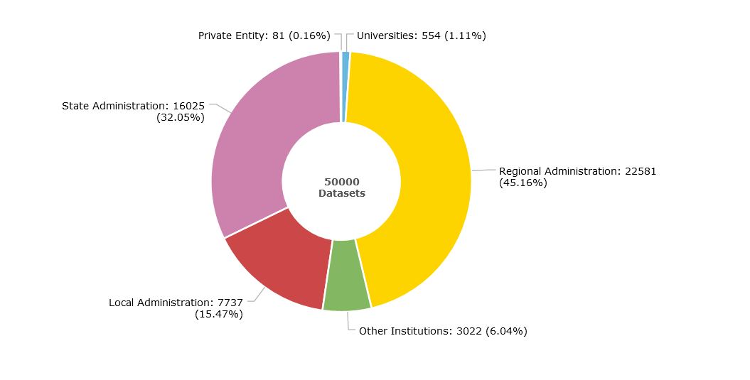
We currently have 160 publishers: 83 belonging to the General State Administration, 17 Autonomous Communities, 44 local entities, 11 universities and 1 private entity. In addition, there are 5 State institutions that do not fall into these categories, such as the Parliament of the Canary Islands.
The organizations that publish the most data in the Catalog are the autonomous administrations (45%), followed by the State (32%) and local administrations (15%), as shown in the following graph. You can obtain more information on the catalog through the scorecard.
From datos.gob.es we invite you to explore our catalog. If you have any questions, you can write to us at contacto@datos.gob.es.