Publication date
26/11/2019
Update date
03/02/2020
Description
The data generated by the agroclimatic stations maintained by the different public administrations and integrated into the Agroclimatic Information System for Irrigation (SiAR) generate valuable open data sets for the agricultural sector. These data, combined with other open data sets, such as weather forecasts, or private data sets, such as the amount of plots irrigation, have important applications in the sector: from the calculation of crop irrigation needs to the choice of the appropriate moment to applicate phytosanitary products.
What is the Agroclimatic Information System for Irrigation (SiAR)?
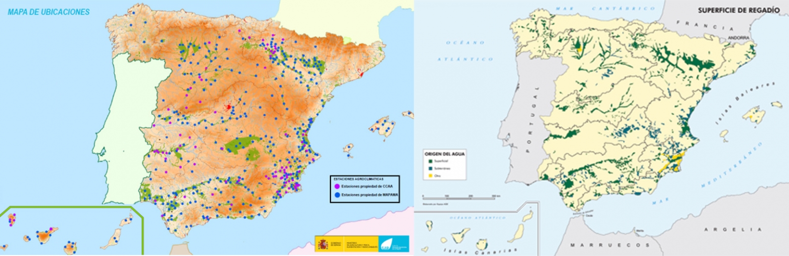
The SiAR network was founded in 1998 with the initial objective of promoting energy and water savings. It has more than 460 stations (Ministry`s stations plus CCAA´s stations), located on irrigated areas of 12 autonomous communities. It is a collaborative network that combines stations of the Ministry and autonomous communities, which also provide direct contact with the irrigator, the end user of the system information.
The Ministry of Agriculture, Fisheries and Food, through the Subdirectorate General for Irrigation and Rural Infrastructure, makes available all the information collected through the entire Network of agro-climatic stations of the SiAR to users for free. All data on the SiAR network is available through the website www.siar.es.
Agroclimatic stations are installed in the irrigable areas, with one station for every 5,000 - 10,000 Ha of irrigation, which implies a coverage of 90% of the irrigable area of Spain.
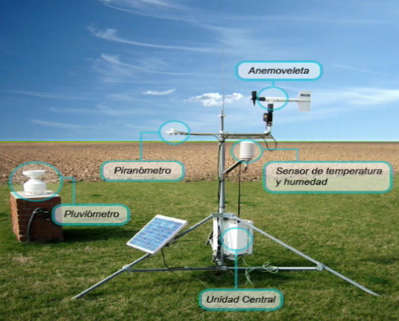
Each station consists of an anemoveleta to measure wind speed and direction, a pyranometer to measure global solar radiation values, a rain gauge that measures rainfall and a temperature and humidity sensor. The station is completed with a central unit that contains the storage and communications devices, necessary to send the data to the central information system automatically with a periodicity of half an hour.
How are the data provided by SiAR?
The data collected by the stations has a high quality, largely due to the exhaustive preventive and corrective maintenance performed on the stations. In addition, all station sensors are periodically taken to the laboratory for calibration.
The stations record temperature and humidity values every 10 minutes and radiation, precipitation and wind speed and direction every 10 seconds, generating average hourly and daily records. The data are provided to users in the form of daily, weekly and monthly records for unregistered and registered users, in addition to the hourly average records.
Can you download the data?
The SiAR website allows the consultation and download of meteorological data with an hourly, daily, weekly or monthly average frequency from one or several stations. In addition to the data query, the user can obtain an estimation of the net needs of the crops, taking into account only the climatic conditions and the type of crop, calculated from the data of the selected station.
The website also allows registered users to create, save and manage data queries and downloads that they can receive automatically, Users can customize them within their private space “My SiAR”.
The data can have multiple purposes of use and are not only used by agricultural professionals. As an example, this video of the Department of Rural and Agrifood Engineering of the Polytechnic University of Valencia shows how SiAR data are used to prove how the calculation of a crop net needs is performed within the design of an irrigation system for a farm.
In addition to these uses, the data can be used by companies that create new products and services from the SiAR data.
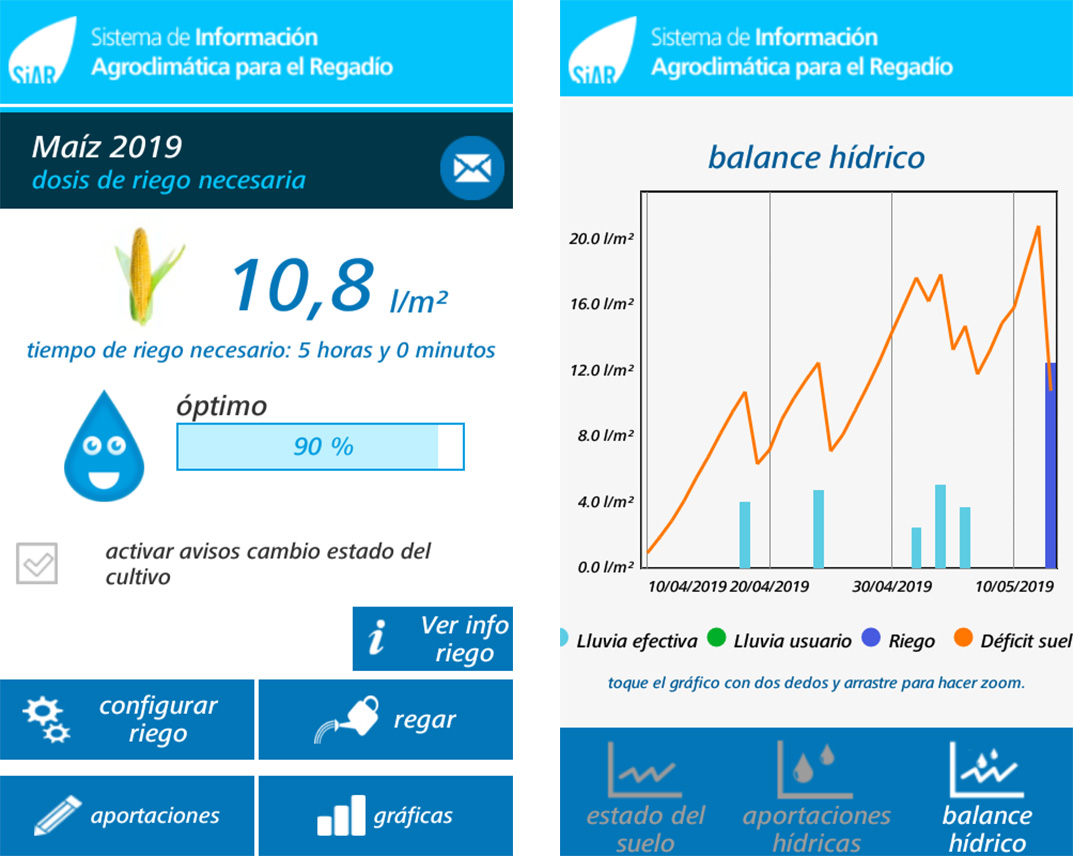
The SiAR app
In addition to the website, the Ministry has the application for mobile devices SiAR app, which allows the management of irrigation programming by calculating the water needs of 104 different crops. The application uses as reference evapotranspiration values those calculated from the data supplied by the closest SiAR station.
SiAR app aims to become a useful tool at the service of the farmer, which helps to optimize the use of water in irrigation, thus promoting its economic, social and environmental sustainability.
Content prepared by Jose Luis Marín, Head of Corporate Technology Strategy en MADISON MK and Euroalert CEO.
Contents and points of view expressed in this publication are the exclusive responsibility of its author.
Que referencia horaria se utiliza para la toma de datas meteorológicos?
Buenas tardes,
El SiAR es una iniciativa independiente de datos.gob.es. Desde datos.gob.es solo nos hacemos eco de ella como ejemplo de reutilización de datos. Para cualquier incidencia técnica, debe ponerse en contacto con el Ministerio de Agricultura, Pesca y Alimentación.
Un saludo.