Blog
A digital twin is a virtual, interactive representation of a real-world object, system or process. We are talking, for example, about a digital replica of a factory, a city or even a human body. These virtual models allow simulating, analysing and predicting the behaviour of the original element, which is key for optimisation and maintenance in real time.
Due to their functionalities, digital twins are being used in various sectors such as health, transport or agriculture. In this article, we review the benefits of their use and show two examples related to open data.
Advantages of digital twins
Digital twins use real data sources from the environment, obtained through sensors and open platforms, among others. As a result, the digital twins are updated in real time to reflect reality, which brings a number of advantages:
- Increased performance: one of the main differences with traditional simulations is that digital twins use real-time data for modelling, allowing better decisions to be made to optimise equipment and system performance according to the needs of the moment.
- Improved planning: using technologies based on artificial intelligence (AI) and machine learning, the digital twin can analyse performance issues or perform virtual "what-if" simulations. In this way, failures and problems can be predicted before they occur, enabling proactive maintenance.
- Cost reduction: improved data management thanks to a digital twin generates benefits equivalent to 25% of total infrastructure expenditure. In addition, by avoiding costly failures and optimizing processes, operating costs can be significantly reduced. They also enable remote monitoring and control of systems from anywhere, improving efficiency by centralizing operations.
- Customization and flexibility: by creating detailed virtual models of products or processes, organizations can quickly adapt their operations to meet changing environmental demands and individual customer/citizen preferences. For example, in manufacturing, digital twins enable customized mass production, adjusting production lines in real time to create unique products according to customer specifications. On the other hand, in healthcare, digital twins can model the human body to customize medical treatments, thereby improving efficacy and reducing side effects.
- Boosting experimentation and innovation: digital twins provide a safe and controlled environment for testing new ideas and solutions, without the risks and costs associated with physical experiments. Among other issues, they allow experimentation with large objects or projects that, due to their size, do not usually lend themselves to real-life experimentation.
- Improved sustainability: by enabling simulation and detailed analysis of processes and systems, organizations can identify areas of inefficiency and waste, thus optimizing the use of resources. For example, digital twins can model energy consumption and production in real time, enabling precise adjustments that reduce consumption and carbon emissions.
Examples of digital twins in Spain
The following three examples illustrate these advantages.
GeDIA project: artificial intelligence to predict changes in territories
GeDIA is a tool for strategic planning of smart cities, which allows scenario simulations. It uses artificial intelligence models based on existing data sources and tools in the territory.
The scope of the tool is very broad, but its creators highlight two use cases:
- Future infrastructure needs: the platform performs detailed analyses considering trends, thanks to artificial intelligence models. In this way, growth projections can be made and the needs for infrastructures and services, such as energy and water, can be planned in specific areas of a territory, guaranteeing their availability.
- Growth and tourism: GeDIA is also used to study and analyse urban and tourism growth in specific areas. The tool identifies patterns of gentrification and assesses their impact on the local population, using census data. In this way, demographic changes and their impact, such as housing needs, can be better understood and decisions can be made to facilitate equitable and sustainable growth.
This initiative has the participation of various companies and the University of Malaga (UMA), as well as the financial backing of Red.es and the European Union.
Digital twin of the Mar Menor: data to protect the environment
The Mar Menor, the salt lagoon of the Region of Murcia, has suffered serious ecological problems in recent years, influenced by agricultural pressure, tourism and urbanisation.
To better understand the causes and assess possible solutions, TRAGSATEC, a state-owned environmental protection agency, developed a digital twin. It mapped a surrounding area of more than 1,600 square kilometres, known as the Campo de Cartagena Region. In total, 51,000 nadir images, 200,000 oblique images and more than four terabytes of LiDAR data were obtained.
Thanks to this digital twin, TRAGSATEC has been able to simulate various flooding scenarios and the impact of installing containment elements or obstacles, such as a wall, to redirect the flow of water. They have also been able to study the distance between the soil and the groundwater, to determine the impact of fertiliser seepage, among other issues.
Challenges and the way forward
These are just two examples, but they highlight the potential of an increasingly popular technology. However, for its implementation to be even greater, some challenges need to be addressed, such as initial costs, both in technology and training, or security, by increasing the attack surface. Another challenge is the interoperability problems that arise when different public administrations establish digital twins and local data spaces. To address this issue further, the European Commission has published a guide that helps to identify the main organisational and cultural challenges to interoperability, offering good practices to overcome them.
In short, digital twins offer numerous advantages, such as improved performance or cost reduction. These benefits are driving their adoption in various industries and it is likely that, as current challenges are overcome, digital twins will become an essential tool for optimising processes and improving operational efficiency in an increasingly digitised world.
Blog
Almost half of European adults lack basic digital skills. According to the latest State of the Digital Decade report, in 2023, only 55.6% of citizens reported having such skills. This percentage rises to 66.2% in the case of Spain, ahead of the European average.
Having basic digital skills is essential in today's society because it enables access to a wider range of information and services, as well as effective communication in onlineenvironments, facilitating greater participation in civic and social activities. It is also a great competitive advantage in the world of work.
In Europe, more than 90% of professional roles require a basic level of digital skills. Technological knowledge has long since ceased to be required only for technical professions, but is spreading to all sectors, from business to transport and even agriculture. In this respect, more than 70% of companies said that the lack of staff with the right digital skills is a barrier to investment.
A key objective of the Digital Decade is therefore to ensure that at least 80% of people aged 16-74 have at least basic digital skills by 2030.
Basic technology skills that everyone should have
When we talk about basic technological capabilities, we refer, according to the DigComp framework , to a number of areas, including:
- Information and data literacy: includes locating, retrieving, managing and organising data, judging the relevance of the source and its content.
- Communication and collaboration: involves interacting, communicating and collaborating through digital technologies taking into account cultural and generational diversity. It also includes managing one's own digital presence, identity and reputation.
- Digital content creation: this would be defined as the enhancement and integration of information and content to generate new messages, respecting copyrights and licences. It also involves knowing how to give understandable instructions to a computer system.
- Security: this is limited to the protection of devices, content, personal data and privacy in digital environments, to protect physical and mental health.
- Problem solving: it allows to identify and solve needs and problems in digital environments. It also focuses on the use of digital tools to innovate processes and products, keeping up with digital evolution.
Which data-related jobs are most in demand?
Now that the core competences are clear, it is worth noting that in a world where digitalisation is becoming increasingly important , it is not surprising that the demand for advanced technological and data-related skills is also growing.
According to data from the LinkedIn employment platform, among the 25 fastest growing professions in Spain in 2024 are security analysts (position 1), software development analysts (2), data engineers (11) and artificial intelligence engineers (25). Similar data is offered by Fundación Telefónica's Employment Map, which also highlights four of the most in-demand profiles related to data:
- Data analyst: responsible for the management and exploitation of information, they are dedicated to the collection, analysis and exploitation of data, often through the creation of dashboards and reports.
- Database designer or database administrator: focused on designing, implementing and managing databases. As well as maintaining its security by implementing backup and recovery procedures in case of failures.
- Data engineer: responsible for the design and implementation of data architectures and infrastructures to capture, store, process and access data, optimising its performance and guaranteeing its security.
- Data scientist: focused on data analysis and predictive modelling, optimisation of algorithms and communication of results.
These are all jobs with good salaries and future prospects, but where there is still a large gap between men and women. According to European data, only 1 in 6 ICT specialists and 1 in 3 science, technology, engineering and mathematics (STEM) graduates are women.
To develop data-related professions, you need, among others, knowledge of popular programming languages such as Python, R or SQL, and multiple data processing and visualisation tools, such as those detailed in these articles:
- Debugging and data conversion tools
- Data analysis tools
- Data visualisation tools
- Data visualisation libraries and APIs
- Geospatial visualisation tools
- Network analysis tools
The range of training courses on all these skills is growing all the time.
Future prospects
Nearly a quarter of all jobs (23%) will change in the next five years, according to the World Economic Forum's Future of Jobs 2023 Report. Technological advances will create new jobs, transform existing jobs and destroy those that become obsolete. Technical knowledge, related to areas such as artificial intelligence or Big Data, and the development of cognitive skills, such as analytical thinking, will provide great competitive advantages in the labour market of the future. In this context, policy initiatives to boost society's re-skilling , such as the European Digital Education Action Plan (2021-2027), will help to generate common frameworks and certificates in a constantly evolving world.
The technological revolution is here to stay and will continue to change our world. Therefore, those who start acquiring new skills earlier will be better positioned in the future employment landscape.
Blog
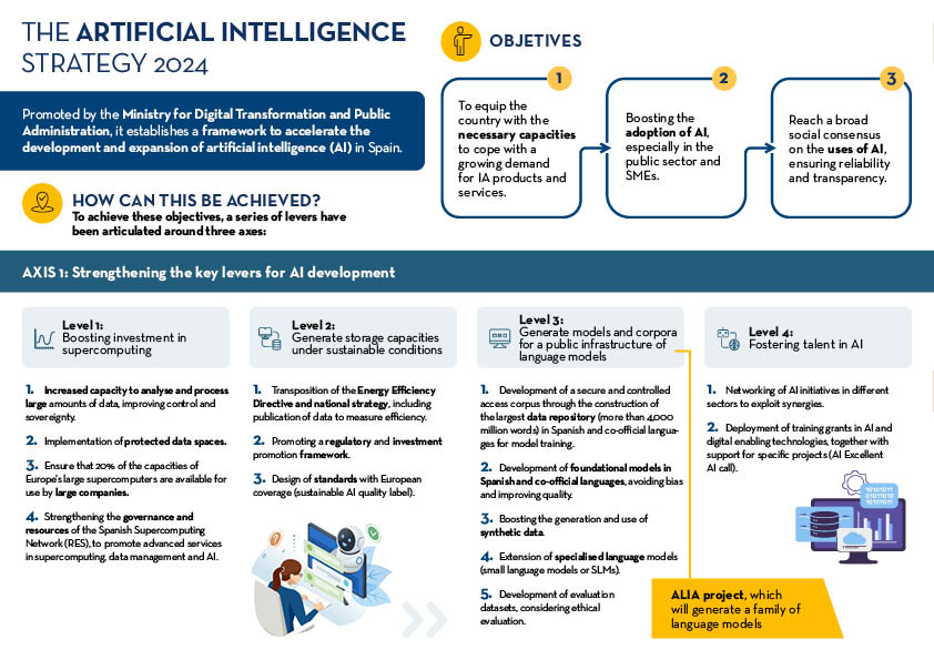
The Artificial Intelligence Strategy 2024 is the comprehensive plan that establishes a framework to accelerate the development and expansion of artificial intelligence (AI) in Spain. This strategy was approved, at the proposal of the Ministry for Digital Transformation and the Civil Service, by the Council of Ministers on 14 May 2024 and comes to reinforce and accelerate the National Artificial Intelligence Strategy (ENIA), which began to be deployed in 2020.
The dizzying evolution of the technologies associated with Artificial Intelligence in recent years justifies this reinforcement. For example, according to the AI Index Report for 2024 by Stanford University AI investment has increased nine-fold since 2022. The cost of training models has risen dramatically, but in return AI is driving progress in science, medicine and overall labour productivity in general. For reasons such as these, the aim is to maximise the impact of AI on the economy and to build on the positive elements of ongoing work.
The new strategy is built around three main axes, which will be developed through eight lines of action. These axes are:
- Strengthen the key levers for AI development. This axis focuses on boosting investment in supercomputing, building sustainable storage capacity, developing models and data to form a public AI infrastructure, and fostering AI talent .
- Facilitate the expansion of AI in the public and private sector, fostering innovation and cybersecurity. This axis aims to incorporate AI into government and business processes, with a special emphasis on SMEs, and to develop a robust cybersecurity framework .
- Promote transparent, ethical and humanistic AI. This axis focuses on ensuring that the development and use of AI in Spain is responsible and respectful of human rights, equality, privacy and non-discrimination.
The following infographic summarises the main points of this strategy:
Go to click to enlarge the infographic
Spain's Artificial Intelligence Strategy 2024 is a very ambitious document that seeks to position our country as a leader in Artificial Intelligence, expanding the use of robust and responsible AI throughout the economy and in public administration. This will help to ensure that multiple areas such as culture or the city design can benefit from these developments.
Openness and access to quality data are also critical to the success of this strategy, as it is part of the raw material needed to train and evaluate AI models that are also inclusive and socially just so that they benefit society as a whole. Closely related to open data, the strategy dedicates specific levers to the promotion of AI in the public sector and the development of foundational and specialised corpora and language models . This also includes the development of common services based on AI models and the implementation of a data governance model to ensure the security, quality, interoperability and reuse of the data managed by the General State Administration (AGE, in Spanish acronyms).
The foundational models (Large Language Models or LLMs) are large-scale models that will be trained on large corpora of data in Spanish and co-official languages, thus ensuring their applicability in a wide variety of linguistic and cultural contexts. Smaller, specialised models (Small Language Models or SLMs) will be developed with the aim of addressing specific needs within particular sectors with a lower demand for computational resources.
Common data governance of the AGE
Open data governance will play a crucial role in the realisation of the stated objectives, e.g. to achieve an efficient development of specialised language models. With the aim of encouraging the creation of these models and facilitating the development of applications for the public sphere, the strategy foresees a uniform governance model for data, including the documentary corpus of the General State Administration, ensuring the standards of security, quality, interoperability and reusability of all data.
This initiative includes the creation of a unified data space to exploit sector-specific datasets to solve specific use cases for each agency. Data governance will ensure anonymisation and privacy of information and compliance with applicable regulations throughout the data lifecycle.
A data-driven organisational structure will be developed, with the Directorate-General for Data as the backbone. In addition, the AGE Data Platform, the generation of departmental metadata catalogues, the map of data exchanges and the promotion of interoperability will be promoted. The aim is to facilitate the deployment of higher quality and more useful AI initiatives.
Developing foundational and specialised corpora and language models
Within lever number three, the document recognises that the fundamental basis for training language models is the quantity and quality of available data, as well as the licenses that enable the possibility to use them.
The strategy places special emphasis on the creation of representative and diversified language corpora, including Spanish and co-official languages such as Catalan, Basque, Galician and Valencian. These corpora should not only be extensive, but also reflect the variety and cultural richness of the languages, which will allow for the development of more accurate models adapted to local needs.
To achieve this, collaboration with academic and research institutions as well as industry is envisaged to collect, clean and tag large volumes of textual data. In addition, policies will be implemented to facilitate access to this data through open licences that promote re-use and sharing.
The creation of foundational models focuses on developing artificial intelligence algorithms, trained on the basis of these linguistic corpora that reflect the culture and traditions of our languages. These models will be created in the framework of the ALIA project, extending the work started with the pioneering MarIA, and will be designed to be adaptable to a variety of natural language processing tasks. Priority will also be given, wherever possible, to making these models publicly accessible, allowing their use in both the public and private sectors to generate the maximum possible economic value.
In short, Spain's National Artificial Intelligence Strategy 2024 is an ambitious plan that seeks to position the country as a European leader in the development and use of responsible AI technologies, as well as to ensure that these technological advances are made in a sustainable manner, benefiting society as a whole. The use of open data and public sector data governance also contributes to this strategy, providing fundamental foundations for the development of advanced, ethical and efficient AI models that will improve public services and drive economic growth drive economic growth. And, in short, Spain's competitiveness in a global scenario in which all countries are making a major effort to boost AI and reap these benefits.
Content prepared by Jose Luis Marín, Senior Consultant in Data, Strategy, Innovation & Digitalization. The contents and points of view reflected in this publication are the sole responsibility of its author.
Blog
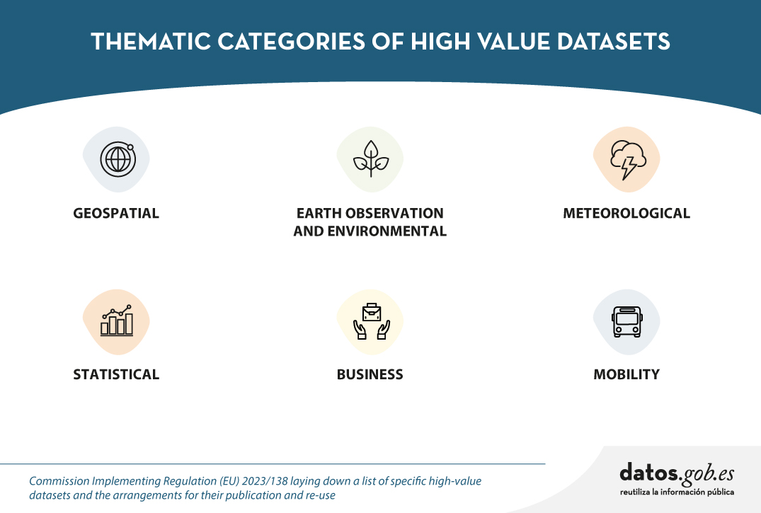
For some time now we have been hearing about high-value dataset, those datasets whose re-use is associated with considerable benefits for society, the environment and the economy. They were announced in Directive (EU) 2019/1024 of the European Parliament and of the Council of 20 June 2019 on open data and the re-use of public sector information, and subsequently defined in Commission Implementing Regulation (EU) 2023/138 of 21 December 2022 establishing a list of specific high-value datasets and modalities for publication and re-use.
In particular, six categories of dataset are concerned: geospatial, Earth observation and environment, meteorology, statistics, companies and company ownership, and mobility. The detail of these categories and how these datasets should be opened is summarised in the following infographic:

Click on the image or here to expand and access the accessible version
For years, even before the publication of Directive (EU) 2019/1024,Spanish organisations have been working to make this type of datasets available to developers, companies and any citizen who wants to use them, with technical characteristics that facilitate their reuse. However, the Regulation has laid down a number of specific requirements to be met. Below is a summary of the progress made in each category.
Geospatial data
For geospatial data, the implementing regulation (EU) 2023/138 takes into account the categories indicated in Directive 2007/2/EC of the European Parliament and of the Council of 14 March 2007 establishing an Infrastructure for Spatial Information in the European Community (INSPIRE), with the exception of agricultural and reference parcels, for which Regulation (EU) 2021/2116 of the European Parliament and of the Council of 2 December 2021applies.
Spain has complied with the INSPIRE Directive for years, thanks to the Law 14/2010 of 5 July 2010 on geographic information infrastructures and services in Spain (LISIGE), which transposes the Directive. Citizens have at their disposal the Official Catalogue of INSPIRE Data and Services of Spain, as well as the catalogues of the Spatial Data Infrastructures of the Autonomous Communities. This has resulted in comprehensive geographical coverage, with exhaustive metadata, which complies with European requirements.
- You can see the dataset currently published by our country in this category on the INSPIRE Geoportal. You can read more about it in this post.
Earth observation and environmental data
For the category of Earth observation and environment data, both the environmental and climate datasets listed in the annexes of the INSPIRE Directive and those produced in the context of a number of legal acts known as priority data, detailed in the Implementing Regulation, are taken into account.
As with the previous category, the fact of having the LISIGE law, which develops INSPIRE and goes further in the obligations set out, has meant that many of these datasets were already available prior to the Implementing Regulation.
- You can see the dataset currently published by Spain in this category in the INSPIRE Geoportal and read more about its publication in Spain here.
Meteorological data
The meteorological thematic category encompasses collections of data on observations measured by various elements, such as weather stations, radars, etc.
In Spain, the State Meteorological Agency (AEMET) has a portal, AEMET OpenData, which was a pioneer in Europe in terms of the availability of open meteorological data. In this portal we find that most of the high-value datasets are already available, grouped in the 14 categories of AEMET OpenData. Work is ongoing to expand the available datasets, their granularity and other technical aspects to further enhance their usability.
- You can see a more detailed review of the current status of the publication status of the datasets in this category in this post.
Statistical data
High statistical value data are covered by a number of legal acts detailed in the Annex to the Implementing Regulation. This category is based on the European Statistical System, which ensures quality and interoperability between states.
In line with this system, Spain has the National Statistical Plan. This plan is developed and implemented through specific annual programmes detailing statistical operations, their objectives, bodies involved and budget appropriations, many of which are aligned with the statistical packages detailed in the Implementing Regulation.
- You can see the detail of the equivalence between the high value data and the datasets published as the result of the National Statistical Plan in this article. You can also see the details of the data published by the National Statistics Institute (INE) here.
Company data and company ownership
Company and company ownership data refer to datasets containing basic company information, including company documents and accounts.
In Spain, information from the Official Gazette of the Mercantile Registry (BORME in Spanish acronyms) is offered openly, with temporal coverage since 2009. However, work continues on opening up more datasets in this category.
Mobility data
The mobility category includes datasets falling under the domain "Transport Networks", included in Annex I of the INSPIRE Directive, together with those referred to in Directive 2005/44/EC of the European Parliament and of the Council of 7 September 2005 on harmonised River Information Services (RIS) on inland waterways in the Community.
As was the case for other categories where high value dataset were already covered by the INSPIRE Directive, Spain has a large amount of dataset available on the Geoportal of the Spatial Data Infrastructure of Spain (IDEE) and the infrastructures of the Autonomous Communities and the infrastructures of the Autonomous Communities.
- You can see the dataset published in the INSPIRE Geoportal and the details of the current situation in this content.
The large amount of dataset published reflects our country's continued commitment to transparency and access to high-value dataset. This is an ongoing effort, the result of the collaboration and involvement of various organisations. Work continues to provide the public with as much quality data as possible.
Noticia
It seems like only yesterday that we were finishing eating our grapes and welcoming the new year. However, six months have already passed, during which we have witnessed many new developments in the world, in Spain and also in the open data ecosystem.
Join us as we take a look back at some of the most newsworthy open data events that have taken place in our country so far this year.
New regulations to boost open data and its use
During the first weeks of 2024, some legislative advances were made in Europe, applicable in our country. On 11 January, the Data Act came into force, which aims to democratise access to data, stimulate innovation and ensure fair use across Europe's digital landscape. You can learn more about it in this infographic that reviews the most important aspects.
On the other hand, at the national level, we have seen how open data is gaining prominence and its promotion is increasingly taken into account in sectoral regulations. This is the case of the Sustainable Mobility Bill, which, among other issues, includes the promotion of open data for administrations, infrastructure managers and public and private operators.
This is a trend that we had already seen in the last days of 2023 with the validation of Royal Decree-Law 6/2023, of 19 December, approving urgent measures for the implementation of the Recovery, Transformation and Resilience Plan for the public service of justice, the civil service, local government and patronage. This Royal Decree-Law includes the general principle of data orientation and emphasises the publication of automatically actionable data in open data portals accessible to citizens. The government's Artificial Intelligence Strategy 2024 also includes references to data held by public bodies. Specifically, it establishes that a common governance model will be created for the data and documentary corpus of the General State Administration in such a way as to guarantee the standards of security, quality, interoperability and reuse of all the data available for the training of models.
In relation to governance, we saw another development at the end of 2023 that has been reflected in 2024: the adoption of the Standard Ordinance on Data Governance in the Local Entity, approved by the Spanish Federation of Municipalities and Provinces (FEMP in its Spanish acronym). Over the last few months, various local councils have incorporated and adapted this ordinance to their territory. This is the case of Zaragoza or Fuenlabrada.
News on data platforms
In this time, new platforms or tools have also materialised that make data available to citizens and businesses:
- The Government of Spain has created the National Access Point for Traffic and Mobility which includes data on the facilities with electric vehicle charging points, detailing the type of connector, format, charging mode, etc.
- The National Institute of Statistics (INE in its Spanish acronym) has launched a Panel of Environmental Indicators. With it, it will be possible to quantify compliance with environmental targets, such as the Green Deal. It has also created a specific section for high-value data.
- The Statistical Institute of the Balearic Islands (IBESTAT in its Spanish acronym) has revamped its web portal which has a specific section on open data.
- Open Data Euskadi has published a new API that facilitates the reuse of public procurement data from the Basque administration.
- MUFACE (General mutual society of civil servants of the State) has launched a space with historical and current data on choice of entity, health care, etc.
- Some of the local authorities that have launched new data portals include the Diputation of Málaga and the City Council of Lucena (Cordoba).
- The Museo del Prado has set up a virtual tour which allows you to tour the main collections in 360º. It also offers a selection of 89 works digitised in gigapixel.
- Researchers from the University of Seville have collaborated in the launch of the PEPAdb (Prehistoric Europe's Personal Adornment database), an online and accessible tool with data on elements of personal adornment in recent prehistory.
In addition, agreements have been signed to make further progress in opening up data and boosting re-use, demonstrating the commitment to open and interoperable data.
- The INE, the State Tax Administration Agency (AEAT in its Spanish acronym), the Social Security, the Bank of Spain and the State Public Employment Service (SEPE) have signed a agreement to facilitate joint access to databases for research of public interest.
- The councils of Castelldefels, El Prat de Llobregat and Esparreguera have joined the Municipal Territorial Information System (SITMUN) to share geographic information and have access to a transversal information system.
- The Universidad Rey Juan Carlos and ASEDIE, the Multisectorial Association of Information, have joined forces to create the Open Data Reuse Observatory which is born with the vision of catalysing progress and transparency in the infomediary field, highlighting the importance of the data-driven economy.
Boosting the re-use of data
Both the data published previously and those published as a result of this work allow for the development of products and services that bring valuable information to the public. Some recently created examples include:
- The government has launched a tool to track the implementation and impact of the Recovery, Transformation and Resilience Plan investments.
- Data on the network of ports, airports, railway terminals, roads and railway lines can be easily consulted with the this visualiser of the Ministry of Transport and Sustainable Mobility.
- The Barcelona Open Data Initiative has presented a new version of the portal DadesXViolènciaXDones a tool for analysing the impact of policies against male violence.
- Madrid City Council has shown how it measures the use of the Cuña Verde Park through data analysis and its GovTech programme.
- Furthermore, in the field of data journalism, we find many examples, such as this article from elDiario.es where one can visualise, neighbourhood by neighbourhood, the price of rent and access to housing according to income.
These data combined with artificial intelligence makes it possible to solve and advance social challenges, as the following examples show:
- The wildINTEL project, of the University of Huelva, in collaboration with the state agency Consejo Superior de Investigaciones Científicas (CSIC), aims to monitor wildlife in Europe. It combines citizen science and AI for effective biodiversity data collection and management.
- Experts at the International University of La Rioja have developed AymurAI, a project that promotes judicial transparency and gender equality through artificial intelligence, based on methodologies with a gender perspective and open data.
- Two researchers from Cantabria have created a model that makes it possible to predict climatic variables in real time and in high resolution by means of artificial intelligence.
On the other hand, to boost the re-use of open data, public bodies have launched competitions and initiatives that have facilitated the creation of new products and services. Examples from recent months include:
- The7th Castile and Leon open data competition.
- The University of Zaragoza's Pedro R. Muro-Medrano Awards.
- The València City Council awards for open data and data journalism projects.
New reports and resources linked to open data
Some of the reports on open data and its re-use published in the first half of the year include:
- The "ASEDIE Report: Data Economy in the infomediary field", now in its twelfth edition.
- The ASEDIE report "Geospatial data in the Ministry of Transport and Sustainable Mobility. Impact of the information co-produced by IGN and CNIG".
- The report "The reuse of open data in Spain" by the COTEC Foundation.
- The "Guide of Good Practices for Data Journalists" elaborated by the Observatori de Dades Obertes i Transparència of the Universitat Politècnica de València (UPV).
A large number of events have also been held, some of which can be viewed online and some of which have been chronicled and summarised:
- The "III National Meeting of Open Data (ENDA): Data to boost the tourism sector", organised by the Deputation of Castellón, the Deputation of Barcelona and the Government of Aragón.
- The round table "Building Tourism Intelligence: Data Sharing for Strategic Decisions in the Tourism Sector" organised by SEGITTUR (State Trading Company for the Management of Innovation and Tourism Technologies) as part of Fitur Know-how & Export.
- The session "Managing Water with Open Data" organised within the framework of the CafèAmbDades initiative of the Generalitat de Catalunya.
- The European Data Portal's workshop "How to use open data for your research", with the participation of the Universidad Politécnica de Madrid.
These are just a fe examples that illustrate the great activity that has taken place in the open data environment over the last six months. Do you know of any other examples? Leave us a comment or write to dinamizacion@datos.gob.es!
Noticia
The Council of Ministers approved in February this year the Sustainable Mobility Bill (PL), a commitment to a digital and innovative transport system in which open mobility data will play a key role.
Inaddition to regulating innovative solutions such as on-demand transport, car sharing or temporary use of vehicles, the regulation will encourage the promotion ofopen data by administrations, infrastructure managers and public and private operators. All this, as stated in Chapter III Title V of the Draft Law "will bring enormous benefits to citizens, e.g. for new mobility and their contribution to the European Green Pact".
This Bill is aligned with the European Data Strategy, which has among its objectives to create a single market for data that ensures Europe' s global competitiveness and data sovereignty through the creation of common European data spaces common European data spaces in nine strategic sectors. In particular, it foresees the creation and development of a common European mobility data space to put Europe at the forefront of the development of a smart transport system, including connected cars and other modes of transport. Along these lines, the European Commission presented its Sustainable and Intelligent Mobility Strategywhich includes an action dedicated to innovation, data and artificial intelligence for smarter mobility. Following in Europe's footsteps, Spain has launched this Sustainable Mobility Bill.
In this post we look at the benefits that the use of open data can bring to the sector, the obligations that the PL will place on data, and the next steps in building the Integrated Mobility Data Space.
Benefits of using open data on sustainable mobility
The Ministry of Transport and Sustainable Mobility, in the web section created for the Law, identifies some of the benefits that access to and use of open transport and mobility data can offer both to the business community and to public administrations and citizens in general:
- Encourage the development of applications that enable citizens to make decisions on the planning of their journeys and during the course of their journeys.
- Improve the conditions of service provision and the travel experience .
- Incentivise research, create new developments and businesses from the data generated in the transport and mobility ecosystem.
- Enable public administrations to have a better understanding of the transport and mobility system in order to improve the definition of public policies and the management of the system.
- Encourage the use of this data for other public interest purposes that may arise.

Ensuring access to open mobility data
In order to make good use of these data and thus take advantage of all the benefits they offer, the Draft Law determines a strategy to ensure the availability of open data in the field of transport and mobility. This strategy concerns:
- transport companies and infrastructure managers, which must drive digitalisation and provide a significant part of the data, with specific characteristics and functionalities.
- administrations and public entities were already obliged to ensure the openness of their data by design, as well as its re-use on the basis of the already existing
In short, the guidelines for re-use already defined in Law 37/2007 for the public sector are respected, and the need to regulate access to this information and the way in which this data is used by third parties, i.e. companies in the sector, is also included.
Integrated Mobility Data Space
In line with the European Data Strategy mentioned at the beginning of the post, the PL determines the obligation to create the Integrated Mobility Data Space (EDIM) under the direction of the Ministry of Transport and Sustainable Mobility, in coordination with the Secretary of State for Digitalisation and Artificial Intelligence. In the EDIM, the aforementioned transport companies, infrastructure managers and administrations will share their data, which will optimise the decision making of all actors when planning the implementation of new infrastructures and the launch of new services.
The Draft Law defines some characteristics of the Integrated Mobility Data Space such as the modular structure, which will include information in a systematic way on different areas of urban, metropolitan and interurban mobility, both for people and goods.
Specifically, the EDIM, according to Article 14, would collect data "in digital form in a free, non-discriminatory and up-to-date manner" on:
- Supply and demand of the different modes of transport and mobility, information on public transport services and mobility services under the responsibility of the administrations
- Financial situation and costs of providing services for all modes of public transport, investments in transport infrastructure, inventory of transport infrastructure and terminals, conditions and degree of accessibility.
- Other data to be agreed at the Sectoral Conference on Transport.
It identifies examples of this type of data and information on the responsibility for its provision, format, frequency of updating and other characteristics.
As referred to in the CP, the data and information managed by the EDIM will provide an integrated vision to analyse and facilitate mobility management, improving the design of sustainable and efficient solutions, and transparency in the design of public transport and mobility policies. In addition, the Law will promote the creation of a sandbox or test environment to serve as an incubator for innovative mobility projects. The outcome of the tests will allow both the developer and the administration to learn by observing the market in a controlled environment.
National Bimodal Transport Access Point
On the other hand, the Bill also provides for the creation of a National Bimodal Transport Access Point that will collect the information communicated to the Ministry of Transport and Sustainable Mobility in the framework of the priority action "Provision of information services on multimodal journeys throughout the Union" of Directive 2010/40/EU which refers to the transport of goods and/or persons by more than one means of transport.
This information will be freely accessible and will also serve to feed the EDIM in the area related to the characterisation of transport and mobility of persons, as well as the National Catalogue of Public Information maintained by the General State Administration.
The Bill defines that the provision of services to citizens using transport and mobility data from the National Multimodal Transport Access Point must be done in a fair, neutral, impartial, non-discriminatory and transparent manner. It adds that the Ministry of Transport and Sustainable Mobility will propose rules for the use of such data within 12 months after the entry into force of this law.
The Sustainable Mobility Bill is currently in parliamentary procedure, as it has been sent to the Spanish Parliament for urgent processing and approval in 2024.
Blog
The Implementing Regulation (EU) 2023/138 of the European Commission sets clear guidelines for public bodies on the availability of high-value datasets within 16 months. These high-value datasets are grouped into the following themes, which were already described in this post post:
This article focuses on the geospatial category, called High-Value Geospatial Datasets (HVDG).
For all HVDGs, the following shall apply Directive 2007/2/EC of the European Parliament and of the Council of 14 March 2007 establishing an infrastructure for spatial information in the European Community (INSPIRE) with the exception of agricultural and reference parcels, for which Regulation (EU) 2021/211/EEC applies Regulation (EU) No 2021/2116 of the European Parliament and of the Council of 2 December 2021.
As reflected in the table below, the regulation provides detailed information on the requirements to be considered for these HVDGs, such as scales or granularity and attributes of each dataset. These are complementary to the attributes defined in the European Regulation (No 1089/2010), which establishes the interoperability of spatial data sets and services.
| Datasets | Scales | Attributes |
|---|---|---|
| Administrative units |
Levels of generalisation available with a granularity down to the scale of 1:5 000. From municipalities to countries; maritime units. |
|
| Geographical names |
Not applicable. |
|
| Directorates | Not applicable. |
|
| Buildings | Levels of generalisation available with a granularity up to the scale of 1:5 000 |
|
| Cadastral parcels | Levels of generalisation available with a granularity up to the scale of 1:5 000 |
|
| Reference areas | Levels of generalisation available with a granularity up to the scale of 1:5 000 |
|
| Agricultural areas | Level of accuracy equivalent to 1:10 000 scale and from 2016, 1:5 000 scale |
|
To ensure the accessibility and re-use of all these valuable datasets, it is imperative to follow certain provisions to facilitate their publication. Here are the key requirements:
- Open Licence: All datasets must be made available for re-use under a licence Creative Commons BY 4.0 or any equivalent less restrictive open licence. This encourages the freedom to share and adapt information.
- Open and Machine Readable Format: Data should be presented in an open, machine-readable format and be publicly documented. This ensures that the information is easily understandable and accessible to any person or automated system.
- Application Programming Interfaces (APIs) and Mass Download: Application programming interfaces (APIs) should be provided to facilitate programmatic access to data. In addition, direct bulk downloading of datasets should be possible, allowing flexible options for users according to their needs.
- Updated version: The availability of datasets in their most up-to-date version is essential. This ensures that users have access to the latest information, promoting the relevance and accuracy of data.
- Metadata: The description of the data will also be carefully taken care of through the use of metadata. This metadata shall, as a minimum, include the elements as defined in Commission Regulation (EC) No 1205/2008 of 3 December 2008. This regulation implements Directive 2007/2/EC of the European Parliament and of the Council and sets standards for metadata associated with datasets. The use of standardised metadata provides additional information essential for understanding, interpreting and using datasets effectively. By following these standards, interoperability and consistency in reporting is facilitated, thus promoting a more complete and accurate understanding of the available data.
These provisions not only promote transparency and openness, but also facilitate collaboration and the effective use of information in a variety of contexts.
Does Spain comply with the Geospatial HVD Regulation?
The INSPIRE (Infrastructure for Spatial Information in Europe) Directive determines the general rules for the establishment of an Infrastructure for Spatial Information in the European Community based on the Infrastructures of the Member States. Adopted by the European Parliament and Council on 14 March 2007 (Directive 2007/2/EC), entered into force on 25 April 2007.
INSPIRE makes it easier to find, share and use spatial data from different countries and in each of the regions, with HVDs available in the the Commission's new catalogue of HVDs and in each of the catalogues of the Spatial Data Infrastructures of the Autonomous Communities, as well as in the Official INSPIRE Data and Services Catalogue of Spain. The information is available through an online platform whit data from different countries.
WARNING!: They are currently working on this Geoportal carrying out the tasks of data dump, therefore, there may be some temporal inconsistency with the data provided, which correspond to the Official Catalogue of INSPIRE Data and Services (CODSI).
In Spain, we can find the Law 14/2010 of 5 July 2010 on geographic information infrastructures and services in Spain (LISIGE), which transposes Directive 2007/2/EC INSPIRE. This law frames the work to make all national spatial data available and obliges the adaptation of national spatial data to the Technical Guides or Guidelines collected by the INSPIRE Directive, thus ensuring that these data are compatible and interoperable in a Community and cross-border context.
LISIGE applies to geographic data that meet these conditions:
- Refering to a geographical area of the national territory, the territorial sea, the contiguous zone, the continental shelf and the exclusive economic zone.
- Having been generated by or under the responsibility of public administrations.
- Being in electronic format.
- Their production and maintenance is the responsibility of a public sector administration or body.
- Being within the themes of Annexes I (Geographic Reference Information), II (Fundamental Thematic Data) or III (General Thematic Data) referred to in the aforementioned law
Furthermore, it is clarified that the geographic data and services regulated by the LISIGE will be available on the NSDI Geoportal and on the CODSI as well as in the rest of the catalogues of the Autonomous Communities. The National Geographic Institute (IGN) is responsible for its maintenance.
Thanks to the tireless efforts of the entire Spanish administration since the publication of LISIGE, Spain has achieved a remarkable milestone. It is currently available on the INSPIRE Geoportal a wide range of information classified as High Value Geospatial Data Set (HVDG) is now available on the INSPIRE Geoportal. This achievement reflects our country's continued commitment to transparency and access to high quality geospatial data.
As of January 2024 Spain has published in the INSPIRE Geoportal and in CODSI the following information related to the High Geospatial Value Datasets (HVD)
- 31 datasets associated with their metadata
- 34 download services (WFS, ATOM Feed, OGC Api Feature)
- 28 visualisation services (WMS, WMTS)
Analysing the sets of high geospatial value we see that, according to the thematics, they have already been published:
| HVDG Spain | Datasets | Download services | Visualisation services | Covers Spanish territory |
|---|---|---|---|---|
| Administrative units |
5 | 7 | 7 | Sí |
| Geographical names |
7 | 8 | 8 | Sí |
| Directorates | 6 | 5 | 7 | Sí |
| Buildings | 5 | 3 | 4 | Sí |
| Cadastral parcels | 3 | 3 | 3 | Sí |
| Reference areas | 3 | 0 | 3 | Sí |
| Agricultural areas | 2 | 2 | 2 | Sí |
Spain currently complies with the HVDG Regulation in all categories. Specifically, it complies with the established legislation at the level of scale or granularity, attributes, license, format, availability of the data in API or maximum download, with being the most updated version and with the metadata.
A detailed analysis of the datasets published under the HVD framework highlights several key issues:
- Comprehensive Geographic Coverage: At least one dataset covering the whole of Spain has been made available.
- Comprehensive Metadata: Metadata has been generated for all High Geospatial Value Datasets (HVDGs). These metadata are published in the Official INSPIRE Catalogue of INSPIRE Data and Services (CODSI), validated to comply with the standards of the Commission Regulation (EC) No 1205/2008.
- Viewing and Downloading Services: All HVDGs have viewing and download services. Download services can be bulk download or download APIs. Currently, they are WFS and ATOM. In the future may be OGC API Feature or API Coverage.
- Open Licences and Open Formats: All published services are licensed under Creative Commons BY 4.0, and download services use standard and open formats such as the GML format documented by the international standard ISO 19136.
- Compliance with INSPIRE Data Models: Almost all datasets comply with the INSPIRE data models, thus ensuring the consistency and quality of the attributes set out in the HVDG regulation.
- Data Updated and Maintained: Download services guarantee the availability of data in the most up-to-date version. Each public administration responsible for the data is responsible for maintaining and updating the information.
This analysis highlights the commitment and efficiency in the management of geospatial data in Spain, contributing to the transparency, accessibility and quality of the information provided to the community.
It should be noted that, in Spain, all HVDG requirements are met. Organisations such as the CNIG and the ICGC or the Government of Navarre, in addition to publishing through WFS or ATOM services, are already working on publishing these datasets with the APIs of OGC.
The INSPIRE Geoportal has become a valuable source of information, thanks to the dedication and collaboration of various governmental entities, including Spanish ones. This breakthrough not only highlights progress in the implementation of geospatial standards, but also strengthens the basis for sustainable development and informed decision-making in Spain. A significant achievement for the country in the geospatial field!
Content prepared by Mayte Toscano, Senior Consultant in Data Economy Technologies. The contents and points of view reflected in this publication are the sole responsibility of its author.
Blog
The Multisectorial Association of Information (ASEDIE), which brings together the infomediary companies of our country, once again includes among its annual objectives the promotion of the reuse of public and private information. Thus, and almost in parallel to the beginning of the new year, last December, ASEDIE shared the progress that the top 3 has experienced in most of the autonomous communities, and the good expectations for the second edition.
Since this initiative was launched last 2019 to promote the opening of three datasets by the autonomous communities, they have been gradually opening datasets that have improved access to information sources, while helping to boost the development of services and applications based on open data. The objective of this project, which in 2021 was included as a commitment to Best Practices in the Observatory of the IV Open Government Plan and supported by the seventeen Autonomous Communities, is to harmonize the opening of Public Sector databases with the aim of encouraging their reuse, promoting the development of the data economy.
First edition: accessible in fifteen autonomous communities
The first edition of Asedie's Top 3 was a success not only because of the datasets selected, but also because of the openness rate achieved four years later. Currently, fifteen of the country's seventeen autonomous communities have managed to open all three databases to the general public: cooperatives, foundations and associations.
2023: the year to complete the opening of the second edition
With the aim of continuing to promote the opening of public information in the different autonomous communities, in 2020, ASEDIE launched a new edition of the top 3 so that those communities that had already overcome the previous challenge could continue to make progress. Thus, for this second edition the selected databases were the following:
- Energy Efficiency Certificates
- Industrial Estates
- Agricultural Transformation Companie
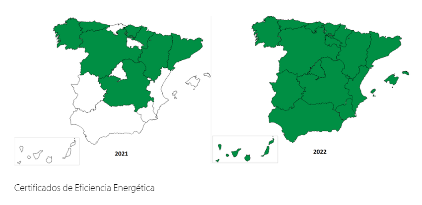
As a result, the second edition of the top 3 is now accessible in seven autonomous communities. Moreover, the databases related to energy efficiency certificates, an increasingly required information at European level, are now openly available in all the autonomous communities of the Spanish geography.
Next steps: extending the commitment to open data
As it could not be otherwise, one of ASEDIE's main annual objectives is to continue promoting regional collaboration in order to complete the opening of the second edition of the top 3 in the rest of the autonomous communities. In parallel, the next edition of the ASEDIE Report will be made public on March 22, taking advantage of the Open Administration Week. As on other occasions, this document will serve to take stock of the milestones achieved in the previous year, as well as to list the new challenges.
In fact, in relation to open data, the ASEDIE report is a very useful tool when it comes to broadening knowledge in this area of expertise, as it includes a list of successful cases of infomediary companies and examples of the products and services they produce.
In short, thanks to initiatives such as those developed by ASEDIE, public-private collaboration is becoming more and more constant and tangible, making it easier for companies to reuse public information.
Noticia
There are only a few days left until the end of summer and, as with every change of season, it is time to review what the last three months have brought in the Spanish open data ecosystem.
In July we learned of the latest edition of the European Commission's DESI (Digital Economy and Society Index) report, which places Spain ahead of the EU average in digital matters. Our country is in seventh position, improving two places compared to 2021. One of the areas where it performs best is in open data, where it ranks third. These good data are the result of the fact that an increasing number of organisations are committed to opening up the information they hold and more reusers are taking advantage of this data to create valuable products and services, as we will see below.
Advances in strategy and agreements to promote open data
Open data is gaining ground in political strategies at national, regional and local level.
In this regard, in July the Council of Ministers approved the draft Act on the Digital Efficiency of the Public Justice Service, an initiative that seeks to build a more accessible Justice Administration, promoting the data orientation of its systems. Among other issues, this act incorporates the concept of "open data" in the Administration of Justice.
Another example, this time at the regional level, comes from the Generalitat de Valencia, which launched a new Open Data Strategy at the beginning of the summer with the aim of offering quality public information, by design and by default.
We have also witnessed the signing of collaboration agreements to boost the open data ecosystem, for example:
- The Ajuntament de L'Hospitalet and the Universitat Politècnica de Catalunya have signed an agreement to offer training to undergraduate and master's degree students in Big Data and Artificial Intelligence, based on open data work.
- The University of Castilla la Mancha has agreed with the regional government to launch the 'Open Government' chair in order to promote higher education and research in areas such as transparency, open data or access to public information.
- The National Centre for Geographic Information (CNIG) and Asedie have signed a new protocol to improve access to geographic information, in order to promote openness, access and reuse of public sector information.
Examples of data reuse
The summer of 2022 will be remembered for the heat waves and fires that have ravaged different corners of the country. A context in which open data has demonstrated its power to provide information on the state of the situation and help in extinguishing fires. Data from Copernicus or the State Meteorological Agency (AEMET) have been used to monitor the situation and make decisions. These data sources, together with others, are also being used to understand the consequences of low rainfall and high temperatures on European reservoirs. In addition, these data have been used by the media to provide the public with the latest information on the evolution of the fires.
Firefighting based on open data has also been developed at the regional level. For example, the Government of Navarre has launched Agronic, a tool that works with Spatial Data Infrastructures of Navarre to prevent fires caused by harvesters. For its part, the Barcelona Provincial Council's open data portal has published datasets with "essential information" for the prevention of forest fires. These include the network of water points, low combustibility strips and forest management actions, used by public bodies to draw up plans to deal with fire.
Other examples of the use of open data that we have seen during this period are:
- The Environmental Radiological Surveillance Network of the Generalitat de Catalunya has developed, from open data, a system to monitor the radiation present in the environment of the nuclear power plants (Vandellòs and Ascó) and the rest of the Catalan territory.
- Thanks to the open data shared by Aragón Open Data, a new scientific article on Covid-19 has been written with the aim of finding out and identifying spatio-temporal patterns in relation to the incidence of the virus and the organisation of health resources.
- The Barcelona Open Data initiative has launched #DataBretxaWomen, a project that seeks to raise public awareness of the existing inequality between men and women in different sectors.
- Maldito dato has used open data from the statistics developed by the National Statistics Institute (INE) based on mobile positioning data to show how the population density of different Spanish municipalities changes during July and August.
- Within its Data Analytics for Research and Innovation in Health Programme, Catalonia has prioritised 8 proposals for research based on data analysis. These include studies on migraines, psychosis and heart disease.
Developments in open data platforms
Summer has also been the time chosen by different organisations to launch or update their open data platforms. Examples include:
- The Statistical Institute of Navarre launched a new web portal, with more dynamic and attractive visualisations. In the process of creation, they have managed to automate statistical production and integrate all the data in a single environment.
- Zaragoza City Council has also just published a new open data portal that offers all municipal information in a clearer and more concise way. This new portal has been agreed with other city councils as part of the 'Open Cities' project.
- Another city that already has an open data portal is Cadiz. Its City Council has launched a platform that will allow the people of Cadiz to know, access, reuse and redistribute the open data present in the city.
- The Valencian Institute of Business Competitiveness (IVACE) presented an open data portal with all the records of energy certification of buildings in the Valencian Community since 2011. This will allow, among other actions, to carry out consumption analysis and establish rehabilitation strategies.
- Aragón Open Data has included a new functionality in its API that allows users to obtain geographic data in GeoJSON format.
- The National Geographic Institute announced a new version of the earthquake app, with new features, educational content and information.
- The Ministry for Ecological Transition and the Demographic Challenge presented SIDAMUN, a platform that facilitates access to territorial statistical information based on municipal data.
- The open data portal of the Government of the Canary Islands launched a new search engine that makes it possible to locate the pages of the portal using metadata, and which allows exporting in CVS, ODS or PDF.
Some organisations have taken advantage of the summer to announce new developments that will see the light of day in the coming months, such as the Xunta de Galicia, which is making progress in the development of a Public Health Observatory through an open data platform, Burgos City Council, which will launch an open data portal, and the Pontevedra Provincial Council, which will soon launch a real-time budget viewer.
Actions to promote open data
In June we met the finalists of the IV Aporta Challenge: "The value of data for the health and well-being of citizens", the final of which will be held in October. In addition, some competitions have been launched in recent months to promote the reuse of open data, for which the registration period is still open, such as the Castilla y León competition or the first UniversiData Datathon. The Euskadi open data competition was also launched and is currently in the evaluation phase.
With regard to events, the summer started with the celebration of the Open Government Week, which brought together various activities, some of them focused on data. If you missed it, some organisations have made materials available to citizens. For example, you can watch the video of the colloquium "Open data with a gender perspective: yes or yes" promoted by the Government of the Canary Islands or access the webinar presentations to learn about the Data Office and the Aporta Initiative.
Other events that have been held with the participation of the Data Office and whose videos are public are: the National Congress on Archives and Electronic Documents and the Data Spaces as ecosystems for entities to reach further.
Finally, in the field of training, some examples of courses that have been launched these months are:
- The National Geographic Institute has launched an Inter-administrative Training Plan, with the aim of generating a common culture among all the experts in Geographic Information of the public bodies.
- Andalucía Vuela has launched a series of free training courses aimed at citizens interested in data or artificial intelligence.
International News
The summer has also brought many new developments at the international level. Some examples are:
- The beginning of the meteorological summer saw the publication of the results of the first edition of the Global Data Barometer, which measures the state of data with respect to societal issues such as Covid19 or climate.
- The 12 finalists of the Eu Datathon 2022 were also announced.
- An interactive edition of Eurostat's regional yearbook 2021 was published.
- England has developed a strategy to harness the potential of data in health and healthcare in a secure, reliable and transparent way.
This is just a selection of news among all the developments in the open data ecosystem over the last three months. If you would like to make a contribution, feel free to leave us a message in the comments or write to dinamizacion@datos.gob.es.
Evento
The pandemic situation we have experienced in recent years has led to a large number of events being held online. This was the case of the Iberian Conference on Spatial Data Infrastructures (JIIDE), whose 2020 and 2021 editions had a virtual format. However, the situation has changed and in 2022 we will be able to meet again to discuss the latest trends in geographic information.
Seville will host JIIDE 2022
Seville has been the city chosen to bring together all those professionals from the public administration, private sector and academia interested in geographic information and who use Spatial Data Infrastructures (SDI) in the exercise of their activities.
Specifically, the event will take place from 25 to 27 October at the University of Seville. You can find more information here.
Focus on user experience
This year's slogan is "Experience and technological evolution: bringing the SDI closer to citizens". The aim is to emphasise new technological trends and their use to provide citizens with solutions that solve specific problems, through the publication and processing of geographic information in a standardised, interoperable and open way.
Over three days, attendees will be able to share experiences and use cases on how to use Big Data, Artificial Intelligence and Cloud Computing techniques to improve the analysis capacity, storage and web publication of large volumes of data from various sources, including real-time sensors.
New specifications and standards that have emerged will also be discussed, as well as the ongoing evaluation of the INSPIRE Directive.
Agenda now available
Although some participations are still to be confirmed, the programme is already available on the conference website. There will be around 80 communications where experiences related to real projects will be presented, 7 technical workshops where specific knowledge will be shared and a round table to promote debate.
Among the presentations there are some focused on open data. This is the case of Valencia City Council, which will talk about how they use open data to obtain environmental equity in the city's neighbourhoods, or the session dedicated to the "Digital aerial photo library of Andalusia: a project for the convergence of SDIs and Open-Data".
How can I attend?
The event is free of charge, but to attend you need to register using this form. You must indicate the day you wish to attend.
For the moment, registration is open to attend in person, but in September, the website of the conference will offer the possibility of participating in the JIIDE virtually.
Organisers
The Jornadas Ibéricas de Infraestructuras de Datos Espaciales (JIIDE) were born from the collaboration of the Directorate General of Territory of Portugal, the National Geographic Institute of Spain and the Government of Andorra. On this occasion, the Institute of Statistics and Cartography of Andalusia and the University of Seville join as organisers.