Documentación
A data space is an ecosystem where, on a voluntary basis, the data of its participants (public sector, large and small technology or business companies, individuals, research organizations, etc.) are pooled. Thus, under a context of sovereignty, trust and security, products or services can be shared, consumed and designed from these data spaces.
This is especially important because if the user feels that he has control over his own data, thanks to clear and concise communication about the terms and conditions that will mark its use, the sharing of such data will become effective, thus promoting the economic and social development of the environment.
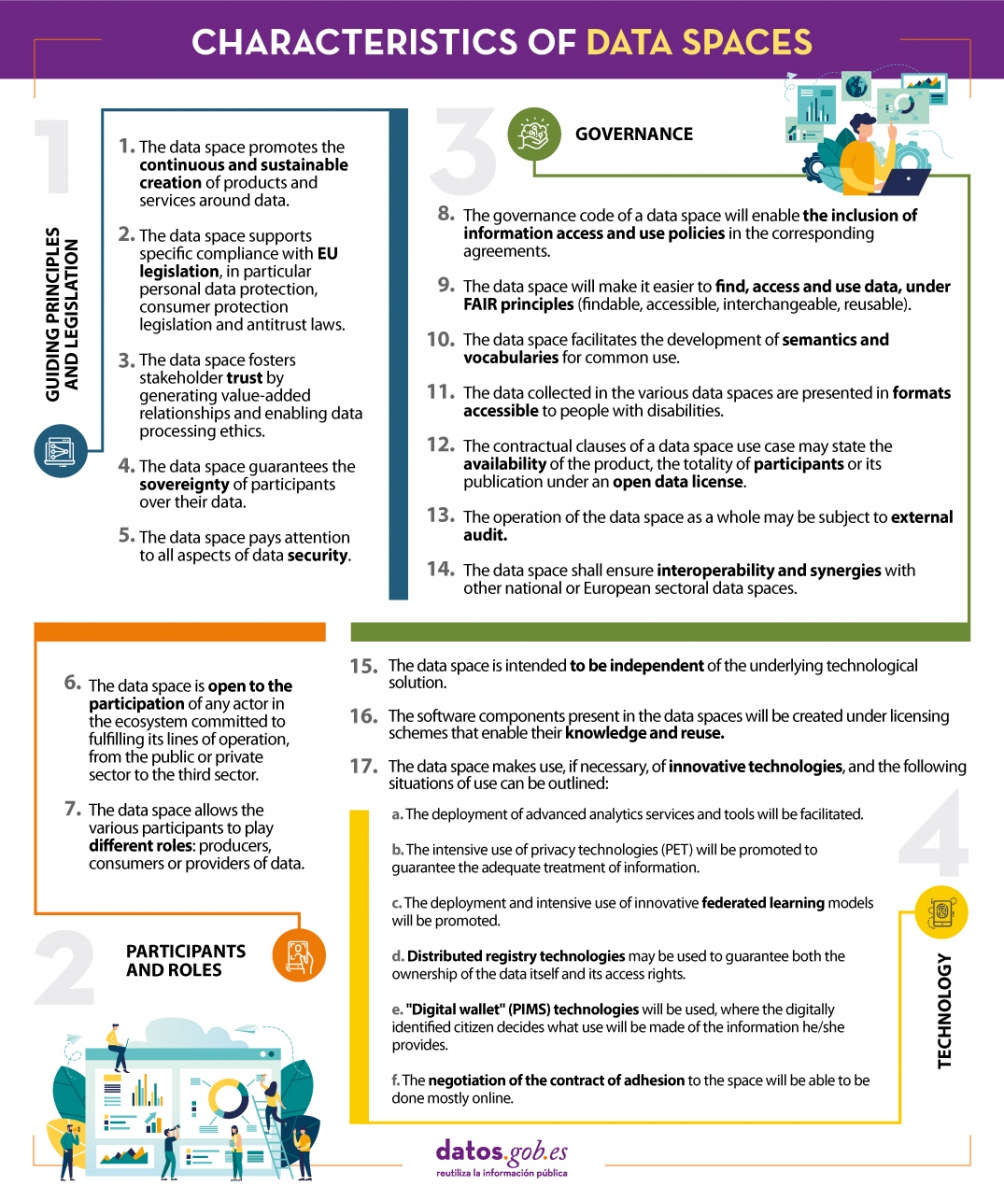
In line with this idea and with the aim of improving the design of data spaces, the Data Office establishes a series of characteristics whose objective is to record the regulations that must be followed to design, from an architectural point of view, efficient and functional data spaces.
We summarize in the following visual some of the most important characteristics for the creation of data spaces. To consult the original document and all the standards proposed by the Data Office, please download the attached document at the end of this article.
(You can download the accessible version in word here)
Blog
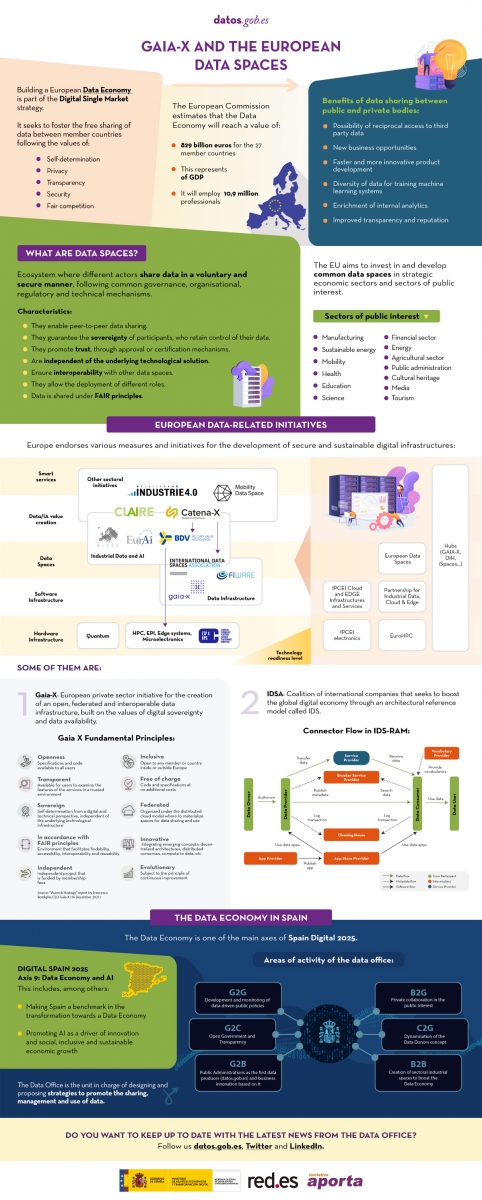
The following infographic shows the context driving the development of data spaces, focusing on some related European initiatives such as Gaia-X and ISDA. For more in-depth content you can read the following articles:
- The importance of deploying European Data Spaces
- Gaia-X and the drive for the data economy
- https://datos.gob.es/en/blog/ids-ram-reference-architecture-model-and-its-role-data-spaces
- The Data Office: the challenge of promoting the Data Economy
Click on the infographic to see it in full size and access the links:
Noticia
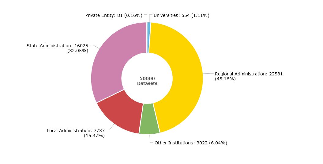
Thanks to the efforts of the 160 organizations that publish data on the datos.gob.es platform, the National Open Data Catalog has reached 50,000 published datasets. Among them, we find datasets published by all levels of administration (state, regional and local), divided into the 22 thematic categories defined in the Technical Interoperability Standard (NTI, in Spanish acronyms), such as Public Sector, Society and Welfare, Environment or Economy.
In this article we want to zoom in on some of these datasets published by organizations belonging to the General State Administration (known as AGE in Spanish), based on three criteria:
- Data that receive a higher number of visits.
- High value and georeferenced data.
- Data with a high potential for reuse.
Most requested data
The Catalog's datasets recorded an average of more than 100,000 visits per month during the past year. These are some examples of the most visited datasets.
- Publisher: Ministry of Industry, Trade and Tourism
- Format: CSV, XLS, KML, XML, JSON and PNG.
Contains information on the price of the different types of fuels in Spanish gas stations, such as gasoline, diesel, liquefied petroleum gases or natural gas (both compressed and liquefied). It also includes the address and opening hours of the establishments.
This dataset is widely used in applications that report on fuel price variations, such as GeoGasolineras, from the Ministry for Ecological Transition and the Demographic Challenge, Search for cheap gas stations in Spain or Gasoline prices on the road, both from private companies.
- Publisher: Ministry of Health
- Format: CSV, HTML, PDF
It collects daily data on cases and incidence of the disease COVID-19, caused by the SARS-CoV-2 coronavirus. It also offers the historical series of cases by Autonomous Communities and Provinces. The data come from those reported by the health services of the Autonomous Communities themselves.
These data have been used to create different visualization tools that facilitate the understanding of the disease, such as the scorecard of the Ministry of Health itself, but it should be noted that there are numerous efforts at provincial and even local level in this area, some of which are included in this website.
- Publisher: Ministry of Territorial Policy and Public Function
- Format: RDF-XML y XLSX
DIR3 codes are three codes assigned respectively to the organizational units, their associated offices and the economic and budgetary management units of a public entity.
This set of data provides a unified and common inventory for the entire Administration, facilitating the distributed and co-responsible maintenance of information.
- Publisher: National Commission for Markets and Competition (CNMC)
- Format: XHTML, ZIP
This is a detailed list of information relating to the different telephone numbering ranges. It also includes the services provided by the teleoperator and the maximum prices, if regulated.
In addition to offering all the data from the CNMC's Telecommunications Numbering Registry by downloading the files in compressed format, the CNMC also provides access to a search engine. On the website of the National Commission for Markets and Competition, a search tool can be accessed to find out directly to which company each telephone number belongs.
High-value geo-referenced data
A georeferenced database is one where the exact location of its elements is defined based on a coordinate system. The referenced data allow us to locate the information on maps and to superimpose layers of information that allow us to perform more in-depth analyses. Below are 4 examples of georeferenced data that you can find in datos.gob.es.
- Publisher: Ministry of Transport, Mobility and Urban Agenda
- Format: XLS y ODS.
It offers urban information on 4,883 municipalities, including 100% of urban areas. Through a cartographic viewer, users can access the graphic and alphanumeric content of the Urban Information System.
This dataset allows a homogeneous and comparable approach to the Spanish urban reality. Among other uses, it offers information of interest in the field of decision making and urban planning.
- Publisher: National Center for Geographic Information
- Format: SHP
It includes geographic information related to municipalities and population entities. It includes the names, coordinates, population, etc. of each one of them.
The reference sources for the elaboration of this database are the Registry of Local Entities (MINHAP), the National Institute of Statistics and cartographic databases of the National Geographic Institute.
- Publisher: Geological and Mining Institute of Spain
- Format: MDB, XLS, HTML, JSON, KMZ, XML, SHP.
This is a database of seismogenic zones of the Iberian Peninsula and its territories of influence. Its use is intended for the calculation of the update of the hazard and earthquake risk map in Spain.
In this viewer you can see in a simple way the different points and know their level of danger.
- Publisher: National Parks Autonomous Agency
- Format: SHP, HTML
It collects the cartography of the natural vegetation and geological systems of the Spanish National Park Network. As it is homogeneous information, it allows comparisons to be made throughout the territory.
A cartographic viewer has also been developed that includes additional information on their location or the species of fauna and flora that inhabit them.
Data with high reuse potential
In datos.gob.es you can find versatile data with a multitude of formats that facilitate its reuse, many of them also georeferenced. Here are some examples:
- Publisher: National Library of Spain
- Format: CSV, HTML, JSON, ODS, plain, XML
Contains descriptions of Spanish libraries and documentation centers in any country. It includes information about their location, type of collection (books, reports, newspaper articles, maps, engravings, etc.) or the type of library (public, school, etc.), among other aspects.
Very useful for integration into tourist or citizen information applications that show the location of various services in a centralized way.
- Publisher: National Center for Geographic Information
- Format: SHP, atom, WFS, WMS
It includes geographic data related to municipal, provincial and autonomic precincts and their boundary lines. The scale used is 1:25,000.
It is very useful to know the space occupied by our towns and to know to which municipality a specific space belongs.
- Publisher: Guadalquivir Hydrographic Confederation
- Format: HTML, ODS, PNG, SHP
It provides the history of drought and water scarcity indicators in the Guadalquivir, Ceuta and Melilla river basin districts, as well as a map of the current status, with a monthly update frequency.
This is an essential dataset for monitoring the situation and promoting informed decision making.
- Publisher: National Institute of Statistics
- Format: CSV, JSON, XLSX, XLS, PC-Axis
The National Institute of Statistics offers open access to a large amount of data extracted from the surveys and studies it carries out periodically. One of them is this dataset containing information on the resident population in Spain. The data can be filtered by date, sex, generation (age on December 31), nationality and place of birth. The INE website includes a search engine to access the data more easily.
This dataset allows to know the characteristics of the Spanish population, and can be crossed with other data (economic, health, etc.) to generate a deeper knowledge of the society.
160 publishing organizations
This is just a small sample of some of the datasets available, but many more can be found in the National Catalog.
We currently have 160 publishers: 83 belonging to the General State Administration, 17 Autonomous Communities, 44 local entities, 11 universities and 1 private entity. In addition, there are 5 State institutions that do not fall into these categories, such as the Parliament of the Canary Islands.
The organizations that publish the most data in the Catalog are the autonomous administrations (45%), followed by the State (32%) and local administrations (15%), as shown in the following graph. You can obtain more information on the catalog through the scorecard.
From datos.gob.es we invite you to explore our catalog. If you have any questions, you can write to us at contacto@datos.gob.es.
Blog
In 2015, the UN adopted the 2030 Agenda for Sustainable Development, an action plan made up of 17 global goals to eradicate poverty, protect the planet and ensure prosperity. This is what is known as the Sustainable Development Goals (SDGs).
In order to measure and evaluate the progress of the SDGs - in addition to their own development - accurate, up-to-date, sufficiently disaggregated, relevant, accessible and user-friendly data and statistics are needed. In other words, quality open data disaggregated by sex, age, municipality, etc. is needed.
In this regard, the UN itself has developed a set of indicators and statistical data aimed not only at monitoring progress, but also at informing policy and ensuring the accountability of all stakeholders. There are 232 indicators that refer to 169 targets. In addition, the Open SDG Data Hub portal provides geographically referenced data by target. Users can explore, analyse and use authoritative data sources on the SDGs to discover patterns, relationships and trends. For its part, the World Bank has an atlas where it presents interactive narratives and data visualizations on the SDGs, using its World Development Indicators database as a primary source.
But what if we want to delve deeper into what is happening in our country with respect to meeting the Sustainable Development Goals?
Resources related to the Sustainable Development Goals in Spain
Several organizations publish open data on the SDGs in our country. Below, we show you several examples at national and regional level.
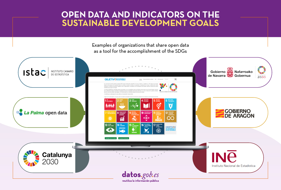
National Statistics Institute (INE)
Through its website, the INE has launched an electronic platform with updated statistical information about the global indicators established by the UN to monitor compliance with the SDGs.
When entering the available sub-indicators, the evolution of the indicator is shown graphically and, when possible, the breakdown by Autonomous Communities, age and sex. Data tables can also be accessed and downloaded in various formats (XLS, CSV, PC-Axis, etc.). These data are also available in our data catalog.
Canary Islands
The Canary Islands Statistics Institute (ISTAC) publishes in open format the indicators of compliance with the SDGs in the Canary Islands. The statistical series shown are harmonized and are comparable between the different autonomous regions as they are the result of the joint work of the different Central Statistical Bodies of the Autonomous Communities (OCECAS).
The ISTAC has created a tutorial showing how to reuse the data hosted in the application.
You can download the data from the platform itself or here.
Navarra
The Government of Navarra has launched a website to show its progress in achieving the Sustainable Development Goals (SDGs). It shows the activities being carried out to meet each of the 17 goals and their impact through graphs and indicators that show the region's progress in the different areas. It includes summaries by region. The data can be downloaded here.
La Palma
The Open Data La Palma portal allows you to explore the available data based on the categories of the Sustainable Development Goals (SDGs). On the homepage of the portal you can click on the image of each goal to see the available data related to it. It is not about indicators, but a different way of organizing the available data.
Aragón
Thanks to the work of the Aragonese Institute of Statistics, this website has been created where you can access different resources related to each of the objectives, including an Excel file with all the regional indicators. The methodological sheet is also available in Word format.
Catalonia
Since 2019, Catalonia's annual statistical action programs incorporate in the official statistics the development, maintenance, updating and dissemination of the integrated system of SDG indicators for the region. To do so, they take as a reference the indicators published by Eurostat and their criteria of quality, robustness and methodological adequacy. On this website you can see the results and download the data in CSV format.
In addition to these examples, there are many initiatives that also share open data on compliance with the SDGs on their websites. This is the case of Andalusia and the Basque Country.
In short, open data is essential for monitoring the progress achieved in the different programs. Therefore, more and more organizations are publishing data in this sense, data that are essential to know the inequalities and that policy makers can seek more accurate solutions. This will help advance implementation and the goal of achieving a fairer world for all.
Content prepared by the datos.gob.es team.
Blog
Throughout history, geospatial data have allowed humankind to better understand its environment. When we talk about geographic or spatial data, we refer to data "that implicitly or explicitly refer to a location relative to the Earth", according to the Spanish Standard UNE 148004:2018. Generally, these data are accessible on maps, visualisers, mobile devices and other media helping us to move and manage the territory in a more efficient way, thus achieving greater progress.
Today, geospatial data remains of particular importance. According to a study by the European Open Data Portal, geospatial data is the second most reused data, behind only statistical data. Both individuals and companies use them to create tools to help citizens in their daily lives - when choosing the most appropriate route to reach a destination -, in management situations - such as fighting a fire - or when they want to disconnect through recreational elements - such as strategy games.
Given this demand, it is not surprising that there is a need for infrastructures that allow us to access this type of information in a harmonised and interoperable way, facilitating its reuse.
What is a Spatial Data Infrastructure (SDI)?
According to the website of the Ministry for Ecological Transition and the Demographic Challenge, a Spatial Data Infrastructure (SDI or IDE in Spanish) "is an information system made up of a set of resources dedicated to managing Geographic Information, available on the Internet, which meet a series of interoperability conditions, and which allow a user, using a simple browser, to use and combine them according to their needs". Through an SDI, geographic information is accessed on the Internet through web services and is catalogued (with metadata) for its location or search, considering regulations, technical documents, international norms and standards that guarantee its interoperability and harmonisation.
It is therefore a mechanism that facilitates the task of searching and accessing geographic data in a uniform manner. This is essential to promote their reuse through the development of digital solutions.
The Spatial Data Infrastructure of Spain (IDEE, in Spanish)
In Spain there are a multitude of geoportals and SDI nodes at state, regional and local level, which are centralised through the geoportal of the Spatial Data Infrastructure of Spain (IDEE). This is a project designed to merge the geographic data with which the Public Administrations of Spain work under the umbrella of the LISIGE and the Regulations of the INSPIRE Directive (Infrastructure for Spatial Information in Europe).
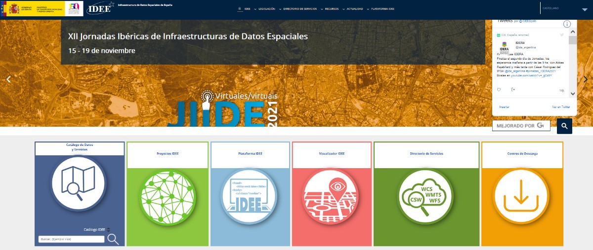
IDEE Geoportal: https://www.idee.es/
The main objective of the IDEE is to publish official geographic information for viewing and downloading and to offer the possibility of locating the data through its descriptions (metadata), so that the data is accessible, machine-readable, easy to locate and reusable. Today, re-use is generally free of charge. To achieve this goal, the NSDI is based on international standards and European regulations that make data interoperable and accessible through open formats.
In charge of coordinating the IDEE is the Consejo Directivo de la Infraestructura de Información Geográfica de España (CODIIGE), created by the Consejo Superior Geográfico, a governing body belonging to the Ministry of Transport, Mobility and Urban Agenda (MITMA). The CODIIGE is made up of representatives of the three levels of the Administration, experts from the Commissions of the High Geographic Council and experts in environmental policies.
The IDEE is part of the European SDI and publishes approximately 250 resources on the European Commission's Geoportal classified by subject.
Who participates in the IDEE?
As mentioned above, the IDEE is made up of the organisations responsible for the data that the European Commission has classified, identified and documented through the INSPIRE Directive Regulation 1089/2010, such as, for example:
- General Directorate of Cadastre, which publishes cadastral plots, buildings and addresses freely and free of charge through viewing and downloading services, allowing this data to be consulted on sites such as the Cadastre's Electronic Headquarters. It is worth highlighting its coordination with the Land Registry. Now any citizen can voluntarily request in a sale or purchase, or at any time, without waiting for the registration of a new act, the incorporation in the Land Registry of a cadastral graphic representation.
- MAPA and MITECO, which work jointly on the publication of data classified as priority data by the European Commission. Its publication is materialised in its IDE geoportal.
- National Centre for Geographic Information (CNIG), responsible for the Cartociudad project, which compiles and publishes freely and free of charge the addresses from the G.D. of Cadastre, the Post Office Group, the National Statistics Institute, the National Geographic Institute, the Autonomous Communities such as the Basque Country, the Community of Navarre, the Community of Valencia, La Rioja, the Balearic Islands and the Community of Madrid, and at a local level, the City Council of Cáceres and the Provincial Council of Madrid.
- Ministry for Ecological Transition and the Demographic Challenge, with its Gas Stations Geoportal application, for searching and visualising service stations, facilitates locating the most economical stations closest to the user through the use of location data.
Other organisations and some of their SDI projects can be consulted on this map.
Other services and web resources of the IDEE
Some time ago we wrote an article about the services and resources included in the IDEE Geoportal, and since then, this geoportal has been complemented with the recent publication of the IDEE Platform, whose main objective is to collect, for the developers of the geospatial community, software development initiatives, thus facilitating the reuse of resources.
In the resources section of the geoportal and the IDEE platform, sections continue to be offered that provide added value beyond the datasets themselves; these are resources published by different administrations and international organisations to facilitate decision-making. To the sections analysed in the previous article, we must add as a novelty a section dedicated to Open Resources on COVID-19, whose incorporation is due to the importance that spatial data are having in the management of this health crisis.
The IDEE also has a blog where questions of interest to all users interested in geographic data are collected.
Want to know more about IDEs?
The Ministry of Transport, Mobility and Urban Agenda has recently published a guide on Spatial Data Infrastructures, which covers the basic concepts, the legal framework, the web technologies needed to implement such an infrastructure, web services, information on how to catalogue geographic information (metadata) and other related topics.
In addition, if you are interested in publishing geographic data, we encourage you to read our "Practical Guide to Publishing Spatial Data", where you will find good practices and guidelines to facilitate the publication of spatial data efficiently on the Internet.
Content prepared by the datos.gob.es team.
Blog
In the last year, we have seen how decisions on health matters have marked the political, social and economic agenda of our country, due to the global pandemic situation resulting from COVID-19. Decisions taken on the basis of public data on cumulative incidence, hospital bed occupancy or vaccination rates have marked our daily lives.
This fact highlights the importance of open health data for the management and decision-making of our governments, but it is also fundamental as a basis for solutions that help both patients and doctors.
The types of data used in the field of health and wellbeing are numerous: results of medical studies and research, anonymised patient records, data on patients' habits (such as how much exercise we do or how much sleep we get) or data linked to health services and management. All these data are of great value that can be exploited by healthcare professionals, providers and citizens alike.
How have health services been using open data?
According to the study "The Open Data Impact Map", a project of the Open Data for Development Network (OD4D), health-related organisations use open data mainly for the purpose of optimising their management and organisation of resources. Of the 124 organisations interviewed in 2018, only 19 indicated that they use open data for the development of health products and services, and only 13 for research. The same study indicates that the most widely used open data are those directly related to health, and that very few organisations combine them with datasets from other themes - mainly geospatial or demographic or social indicators - to generate deeper and more detailed knowledge.
However, the opportunities in this field are vast, as shown below.
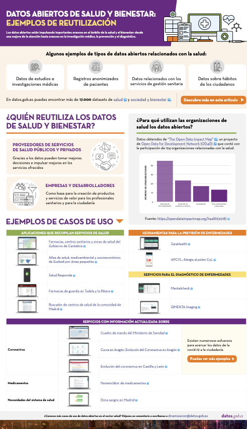
Click here to see the infographic in full size and in its accessible version
Examples of services based on open health data
The situation seems to be changing and there is increasing momentum for the implementation of applications, services or projects based on data in this field. Europe is committed to the creation of data spaces focused on the field of health, as part of its strategy to build a European cloud, while the Spanish government has included the promotion of Digital Health solutions in its Digital Spain 2025 strategy. Among the actions envisaged by our country is the streamlining of information systems to enable better data sharing and interoperability.
Applications that collect health services
When it comes to health apps, the most common are those that help citizens find local healthcare providers that meet their needs. An example is 24-hour pharmacies in Tudela and la Ribera or the search engine for health centres in the community of Madrid. Thanks to these, patients can find out where the centres are located and find out information of interest, such as opening hours. Some applications include additional services, such as Salud Responde, from the Junta de Andalucía, which allows the request and modification of medical appointments, improving the efficiency of the system.
But such services can also provide important information for more efficient resource management, especially when cross-referenced with other datasets. For example, Pharmacies, Health Centres and Health Areas of the Government of Cantabria, developed by Esri, includes information on the territorial organisation of health resources according to geographical, demographic, epidemiological, socio-economic, labour, cultural, climatological and transport factors. Its main objective is not only to facilitate citizens' access to this information, but also to ensure that "the provision of health services is carried out in the best conditions of accessibility, efficiency and quality".
The Health, environmental and socio-economic atlas of the Basque Country by small areas shows a series of maps with the aim of "monitoring geographical inequalities in health, socioeconomic and environmental indicators in the Basque Country, taking into account the gender perspective". This information is very useful for service managers in trying to promote greater equity in access to healthcare.
Disease prevention tools
There are also applications on the market aimed at disease prevention, such as ZaraHealth, a web application that displays real-time data on water quality, air quality and pollen levels in the city of Zaragoza. The user can set a series of thresholds for pollen and pollution levels, so that a warning is issued when they are reached. In this way, they can avoid going outdoors or exercising in areas that do not meet their needs. APCYL: Allergy to pollen CyL has the same goal.
Another important aspect of our health is our diet, a key factor in the prevention of various pathologies such as cardiovascular diseases or diabetes. Websites such as Mils, which offers detailed nutritional information on food, can help us to eat more healthily.
Services for the diagnosis and treatment of diseases
Open data can help assess health outcomes, develop more effective treatments and predict disease outbreaks.
In the field of mental health, for example, we find Mentalcheck, an app that enables psychological assessments and self-reporting via mobile devices. It aims to improve Ecological Momentary Assessment and Intervention (EMA and EMI). The application incorporates open data on medications and mental health services from the US Food and Drug Administration (FDA). It also allows the integration of psychological and physiological data to generate correlations.
Another example is Qmenta, a company focused on analysing brain data, using MRI and related clinical data. In recent months they have also incorporated open data related to COVID-19 in some of their work. Through medical image processing algorithms, they seek to accelerate the development of new therapies for neurological diseases.
Up-to-date information on diseases or system needs
Another area where open data can drive improvements is in the reporting of certain situations. This has become especially important in the context of the global pandemic where citizens demand constant and updated information. In this sense, we find the scorecard of the Ministry of Health at state level and different regional initiatives, such as Curve in Aragon: Evolution of Coronavirus in Aragon, or Evolution of the coronavirus in Castilla y León. These are just a couple of examples, but it should be noted that there are numerous efforts in this area, as the Ministry of Health reports on its website.
It is also important to make information on medicines transparent, both for doctors and patients, by facilitating comparisons. In this regard, the Nomenclature of Medicines shows more than 20,000 medicines marketed in Spain with Social Security coverage, offering information on price, presentation, links to the package leaflet, safety notes and active ingredients, among others.
Finally, it is also important to provide information on resource needs, for example, doctor vacancies or the state of blood reserves.
Data in general has driven important advances in improving health outcomes, from increased access to care to medical research and diagnosis. Open data is a key ingredient that can help further enrich these solutions with new variables. It is therefore essential that more and more health and wellness data will be opened, following a set of guidelines and standards that ensure the privacy and security of patients. In this sense, the report "Open data and health: technological context, stakeholders and legal framework" includes information on what types of data can be opened and what the legal framework says about it.
Do you know more use cases of open data applied to the health and welfare sector? Leave us a comment or write to dinamizacion@datos.gob.es.
Content prepared by the datos.gob.es team.
Blog
Open data is a source of information for the development of smart services, as well as for decision-making and policy-making. It is therefore not surprising that an increasing number of public bodies, in addition to opening data - for reuse by others and for reasons of accountability and transparency - are also reusing their own data for different purposes.
In this sense, the rise of smart city management platforms is encouraging many city councils and autonomous communities to develop smart applications and tools that take advantage of the use of data and analytical techniques to innovate and improve the public services they offer to citizens. Below, we show you several examples.
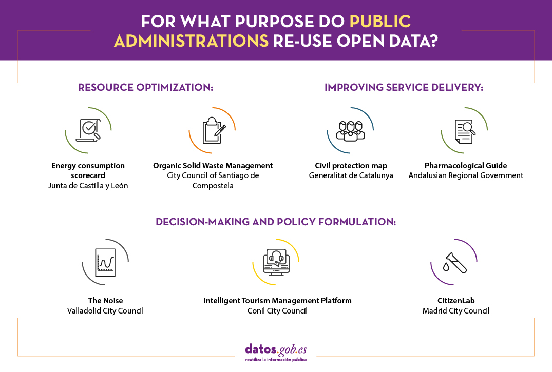
Resource optimisation
Open data can be used by public bodies to understand how public resources are being managed, as well as to promote actions that enable more efficient management and economic savings, e.g. in terms of energy consumption or by promoting more efficient resource management.
Energy consumption scorecard. Junta de Castilla y León.
This energy datahub, developed by the open data initiative of the Junta de Castilla y León, offers detailed and visual information on energy consumption in the centres managed by the Junta, such as educational centres, health centres, administrative offices or hospitals, among others.
It is a scorecard that gathers information from more than 1,500 consumption centres, offering different types of graphical representations that make it easier for the reader to understand the data. The data source used for the development of this platform can be consulted via this link.
The tool facilitates disaggregated analysis by type of energy and geographical location. This information may be of interest to citizens, but also to the Board's own managers. Thanks to this platform, between 2015 and the beginning of 2020, the Board saved more than 12 million euros in electricity.
In addition, the regional government has an electricity table that focuses exclusively on the electricity consumption of hospitals in Castilla y León on an hourly basis. The data is linked to meteorological information, so that future costs can be estimated and the use of heating can be optimised. The data used to develop this table can be consulted here.
Organic solid waste management. City Council of Santiago de Compostela.
The City Council of Santiago de Compostela has launched, within the Smartiago initiative, a project that aims to achieve a sustainable and intelligent management of municipal solid waste (MSW). The main objective of this tool is to design, develop and build smart surface containers for the characterisation of organic solid waste, based on the use of open IoT technologies, the application of machine learning algorithms and the use of open data as sources for the enrichment of community composting prediction models. This aims to achieve the 50% readiness for reuse and recycling target, up from the current 13%. The project, currently under development, will also include a gamification app to encourage good practices in sustainability.
Improving service delivery
Thanks to open data it is also possible to create tools for social service professionals to provide a better response and attention to the needs of citizens. Let's look at a couple of examples:
Civil protection map. Generalitat de Catalunya.
This interactive map shows the main resources of the civil protection system in Catalonia. The civil protection map allows you to see where the different risks are located (technological, environmental...) and the situation of the teams in order to better plan responses. Here you can consult the main source of data used by this tool.
Pharmacological Guide. Andalusian Regional Government.
This application has been designed by the Andalusian Regional Government to offer healthcare professionals a faster and more efficient consultation of the main drugs used in emergency care in Andalusia. It is a useful working tool for those healthcare professionals who aid in critical situations as it includes constantly updated and contrasted information on the main indications, doses, contraindications and interactions of the most commonly used drugs.
Decision-making and policy formulation
Open data provides greater knowledge about what is happening around us, enabling us to make better decisions. It is a very useful tool for public bodies to develop policies that respond to the real needs of citizens. Over the last year, we have seen how measures to prevent the spread of COVID-19 have been taken on the basis of data on the evolution of the disease. Other examples are:
The Noise Map. Valladolid City Council.
Valladolid City Council has a Noise Map that organises information on noise pollution. This map has been developed to be used in a compulsory way in the execution of the calculations foreseen in the different regulatory standards, as well as in the technical building code and which will apply to residential, institutional and industrial buildings, as well as in the technical building code and which will apply to residential, institutional and industrial buildings.
Intelligent tourism management platform. Conil Town Council.
Within the framework of Red.es' Smart Cities, Territories and Islands calls for proposals, we are finding more and more proposals that include the development of data management platforms that promote efficient decision-making. One example is the City Council of Conil de la Frontera, which is working with a smart tourism management platform to increase the knowledge of tourists, through the aggregation and centralisation of data related to the origin of the tourist, mobility and most visited areas, preferred places to visit and stay overnight or satisfaction surveys, among other parameters. In this way, the local administration can identify patterns and carry out actions to adapt and improve management, detect irregularities, promote economic and business development or favour the generation of employment in the priority areas identified. These data have also been used to estimate the real population during the pandemic and to make a better estimate of incidence rates. Although these data do not appear to be public for the moment, the aim is to open them to companies through an open data platform.
CitizenLab. Madrid City Council.
The regional government of Madrid, together with Grant Thornton, has launched a datalab to better understand citizen behaviour. The project seeks to analyse predictive models of citizen behaviour using Big Data and Artificial Intelligence (AI), with the aim of improving public services in the Madrid region in areas such as mobility, healthcare, tourism and infrastructure. In the last year, for example, it has been used to predict the demand for vaccines.
Undoubtedly, there are numerous applications and digital tools used by public administrations - and it seems that there will be more - that base their operation on open data to offer more and better services to citizens. In this article we have compiled some examples, but if you know of any related ones that may be of interest, do not hesitate to leave a comment or write to us at our email address dinamizacion@datos.gob.es.
Content prepared by the datos.gob.es team.
Noticia
The Cross-Forest project combines two areas of great interest to Europe, as set out in the Green Deal. On the one hand, the care and protection of the environment - in particular our forests-. On the other hand, the promotion of an interoperable European digital ecosystem.
The project started in 2018 and ended on 23 June, resulting in different tools and resources, as we will see below.
What is Cross-Forest?
Cross-Forest is a project co-funded by the European Commission through the CEF (Connecting Europe Facility) programme, which seeks to publish and combine open and linked datasets of forest inventories and forest maps, in order to promote models that facilitate forest management and protection.
The project has been carried out by a consortium formed by the Tragsa Public Group, the University of Valladolid and Scayle Supercomputacion of Castilla y León, with the institutional support of the Ministry for Ecological Transition and the Demographic Challenge (MITECO, in Spanish acronyms). On the Portuguese side, the Direção-Geral do Território of Portugal has participated.
The project has developed:
- A Digital Services Infrastructure (DSI) for open forest data, oriented towards modelling forest evolution at country level, as well as predicting forest fire behaviour and spread. Data on fuel materials, forest maps and spread models have been used. High Performance Computing (HPC) resources have been used for their execution, due to the complexity of the models and the need for numerous simulations.
- An ontological model of forest data common to public administrations and academic institutions in Portugal and Spain, for the publication of linked open data. Specifically, a set of eleven ontologies has been created. These ontologies, which are aligned with the INSPIRE Directive, interrelate with each other and are enriched by linking to external ontologies. Although they have been created with a focus on these two countries, the idea is that any other territory can use them to publish their forest data, in an open and standard format.
The different datasets used in the project are published separately, so that users can use the ones they want. All the data, which are published under CC BY 4.0 licence, can be accessed through this Cross-Forest Github repository and the IEPNB Data Catalogue.
4 flagship projects in Linked Open Data format
Thanks to Cross-Forest, a large part of the information of 4 flagship projects of the General Directorate of Biodiversity, Forests and Desertification of the Ministry for Ecological Transition and the Demographic Challenge has been published in linked open data format:
- National Forest Inventory (IFN-3). It includes more than 100 indicators of the state and evolution of the forests. These indicators range from their surface area or the tree and shrub species that inhabit them, to data related to regeneration and biodiversity. It also incorporates the value in monetary terms of the environmental, recreational and productive aspects of forest systems, among other aspects. It has more than 90,000 plots. Two databases corresponding to a subset of the NFI indicators have been published openly.
- Forest Map of Spain (Scale 1:50.000). It consists of the mapping of the situation of forest stands, following a conceptual model of hierarchical land uses.
- National Soil Erosion Inventory (INES). This is a study that detects, quantifies and cartographically reflects the main erosion processes affecting the Spanish territory, both forest and agricultural. Its objective is to know its evolution over time thanks to continuous data collection and it has more than 20,000 plots.
- General Forest Fire Statistics. It includes the information collected in the Fire Reports that are completed by the Autonomous Communities for each of the forest fires that take place in Spain.
These datasets, along with others from this Ministry, have been federated with datos.gob.es, so that they are also available through our data catalogue. Like any other dataset that is published on datos.gob.es, they will automatically be federated with the European portal as well.
The predecessor of this project was CrossNature. This project resulted in the Eidos database, which includes linked data on wild species of fauna and flora in Spain and Portugal. It is also available on datos.gob.es and is reflected in the European portal.
Both projects are an example of innovation and collaboration between countries, with the aim of achieving more harmonised and interoperable data, facilitating to compare indicators and improve actions, in this case, in the field of forest protection.
Blog
Open mobility data plays a key role in transforming current transport networks and systems, promoting their digitization and improving their sustainability and efficiency. The European Union is aware of this situation, and for this reason it has not only included mobility data among the categories considered of high value in the directive (EU) 2019/1024, but also highlighted its importance in the new "Sustainable and smart mobility strategy", including lines of action related to its impulse, how we approach previously.
In this new article we are going to focus on the situation in Spain, where measures related to open data have also been included in the national mobility strategy.
The Secure, Sustainable, Connected Mobility Strategy 2030
The Secure, Sustainable, Connected Mobility Strategy 2030 (es.movilidad) published by the Ministry of Transport, Mobility and Urban Agenda (MITMA) in September 2020 recognizes the importance of open data in the process of digitization and automation of transport, as well as the regulatory challenges posed by collection conditions, transfer and access to the data generated in the different parts of the value chain. For this reason, the strategy proposes that a future Law on Sustainable Mobility and Transport Financing addresses these issues, offering solutions that eliminate barriers to the opening of data andwhat guarantee the privacy of users and the protection of different business strategies.
Although they are present in other measures, in axis 5 (Intelligent Mobility) of the Strategy there are four measures, three of them within the line of action for the Facilitation of Mobility as a Service, Open Data and New Technologies for Analysis and Optimization of Mobility, in which open data explicitly plays a prominent role:
- To the extent designed to promote the publication of open mobility data from MITMA in coordination with the data.gob.es platform aims to adopt a proactive role in making open data available (both planned and in real operation) that are relevant to society.
- The implementation of the National Data Access Point for multimodal travel aims to create a single repository of open transport data (schedules, fares, routes, geographical coordinates of stops, etc.) provided by transport authorities, operators, providers of shared mobility services or transport services on demand, infrastructure managers, etc. anyway at the national level. In this sense, it should be noted that MITMA intends to go beyond the mandatory minimum and create three other national access points (real-time traffic, safety information in relation to traffic and safe parking for freight transport).
- To promote the development of mobility applications, guaranteeing the availability of quality and real-time data, MITMA will analyze the convenience of promoting complementary regulation so that all transport operators, infrastructure managers, and transport service providers on demand. provide dynamic, reliable and real-time data of their transport services to be made available to third parties.
- Finally the design and implementation of the SIMPLE technology platform, also foresees the reuse of information throughout the logistics and transport chain, based on the principle of providing unique data only once. This platform will allow to know the traceability of goods in the different means of transport and, on the other hand, will allow the interconnection between the Public Administration and the different agents of the private logistics sector to facilitate trade and transport, nationally and internationally.
These measures are summarized in the following image:

On the other hand, a request for expressions of interest to identify proposals for the integration of artificial intelligence in the value chains of the economy in order to promote the digital transformation of the economic fabric, within the framework of Recovery Plan. And one of the five axes on which one's own National Artificial Intelligence Strategy (ENIA) recognizes the impact of AI and data is of course, sustainable and smart mobility. It should be noted that it is an invitation aimed at projects in the phases closest to the market of the innovation process based on medium to high maturity technologies (TRL 6 onwards) as a complement to R&D support actions.
Now that the pandemic period is coming to an end, the economic recovery effort opens up fascinating opportunities for innovation and digital transformation in sectors where the penetration of artificial intelligence and the use of data so far has been much lower than the sector of the information technologies, something that not only happens in mobility and transport but also in the farming, energy or health and education.
We are therefore faced with a unique opportunity that we cannot afford to miss; which is also accompanied by a significant boost in the form of public financing and in which transport and mobility stand out due to their impact not only on the economy, but also on the environment and on the quality of life of citizens.
Content written by Jose Luis Marín, Senior Consultant in Data, Strategy, Innovation & Digitalization.
The contents and points of view reflected in this publication are the sole responsibility of its author.
Blog
The IV Open Government Plan 2020-2024 represents a new step in the achievement of the Sustainable Development Goals promoted by the United Nations within the framework of the 2030 Agenda adopted by its General Assembly. Specifically, for the achievement of number 16, related to Peace, Justice and Strong Institutions.
The Plan was approved in October 2020 by agreement of the Plenary of the Open Government Forum, a collegiate body attached to the General State Administration. This body has the participation of other Administrations and civil society which, on the other hand, have played an important role in its preparation process. In this regard, it should be noted that, in line with the principles of Open Government, the Plan was drawn up on the basis of a process of open consultation with society, in which almost 70% of the comments referred to transparency, accountability and open data.
Among the main challenges, the IV Plan raises the need to strengthen transparency, public access to information and accountability. To this end, the firm commitment to promote open data and the reuse of public sector information is of particular importance, especially with regard to the possibilities of promoting preventive systems of public integrity and, specifically, in the area of public sector procurement. This is undoubtedly a commitment that entails a relevant cultural and organizational change that inexcusably requires training actions both for the staff of Public Administrations and for society in general.
The Open Government Plan and the reuse of public sector information
The Plan includes the main commitments in this area in order to "contribute to a more just, peaceful and inclusive society". In the specific case of transparency, open data and accountability, the Plan indicates that they will be promoted "through the development of actions aimed at their improvement and the evaluation of the results of public plans and programs", which necessarily entails a modification of the current regulations on transparency, access to information, open data and reuse of public sector information.
Specifically, the transposition of the new features incorporated in Directive (EU) 2019/1024 of the European Parliament and of the Council, of June 20, 2019, is contemplated as a first step. In this regard, it is considered that such reform may have a high transformative and fostering impact on the data ecosystem in that it requires extending the scope of the current regulatory framework. As regards the material execution of this commitment, the starting date is July 2020 -when a public consultation was opened prior to the preparation of the corresponding Preliminary Draft Bill- and the end date is July 17, 2021, when the new state legislation should have been definitively approved.
Main commitments of the IV Open Government Plan 2020-2024
In the process of preparing the Plan, special attention was paid to the contributions of the different public and private entities that form part of the Open Government Forum through their participation in various meetings and working groups, in addition to the aforementioned open consultation process with civil society.
During the process of preparing the Plan, the public administrations themselves included contributions of special interest. These are commitments that have been made and are included as proposals for improvement in the Plan itself. Apart from the promotion of the aforementioned general regulations, from the point of view of the initiatives promoted by state public entities, proposals were presented that were certainly relevant. These include the National Institute of Public Administration's data on the selection and training of civil servants, the implementation of a Climate Open Data by AEMET, the dissemination in open formats of the information of the Spanish Tourism Quality System, the promotion of an ecosystem of open geographic data and services, as well as the opening of data from the Commercial Registry.
With regard to the initiatives proposed by the Autonomous Communities, the following commitments stand out:
- At the regulatory level, of particular relevance is the commitment of the Junta de Castilla y León to approve a new legislation on transparency, access and reuse of public information, the processing of which is underway with the drafting of a preliminary draft already submitted to the corresponding hearing process.
- With regard to specific training on open data, the implementation of a specific training plan on open data aimed at the staff of the Junta de Andalucía within the framework of a broader plan that also includes the promotion of big data is noteworthy.
- The commitment to its own governance model is also present in the development of an open data strategy to promote the reuse of information in the Valencian public sector.
- With the aim of improving the conditions of access to information, the Canary Islands government is considering the implementation of a single centralized portal for access to open data, an approach that is also present in the evolution towards a single data catalog in Navarra.
- Finally, as regards the promotion of open data in some sectorial areas of special relevance, the Catalan Government intends to promote open data linked to gender equality policies.
In short, this new Plan updates and specifies the roadmap for the public sector in Spain with regard to the promotion of open data and the reuse of public sector information. This is a topic of special importance during the year 2021 for the promotion of Open Government from a legal perspective, given the need to approve a new state legislative framework and, likewise, the foreseeable adoption of other regulatory initiatives at European level
Content prepared by Julián Valero, professor at the University of Murcia and Coordinator of the Research Group "Innovation, Law and Technology" (iDerTec).
Contents and points of view expressed in this publication are the exclusive responsibility of its author.