


Urbanismo e infraestructuras
-
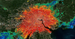 Urban Heat Islands: How Geospatial Open Data Can Make Our Cities More Resilient
09-07-2025
Urban Heat Islands: How Geospatial Open Data Can Make Our Cities More Resilient
09-07-2025
Cities account for more than two-thirds of Europe's population and consume around 80% of energy. In this context, climate change is having a particularly severe impact on urban environments, not only because of their density, but also because of their...
-
 Building footprints: open data that saves lives in emergencies
09-04-2025
Building footprints: open data that saves lives in emergencies
09-04-2025
In a world increasingly exposed to natural hazards and humanitarian crises, accurate and up-to-date geospatial data can make the difference between effective response and delayed reaction. The building footprints, i.e. the contours of buildings as they...
-
 New geospatial data capture techniques: innovations for more efficient data governance
30-01-2025
New geospatial data capture techniques: innovations for more efficient data governance
30-01-2025
Geospatial data capture is essential for understanding our environment, making informed decisions and designing effective policies in areas such as urban planning, natural resource management or emergency response. In the past, this process was mainly...
-
 Digital twins: advantages and use cases in Spain
15-10-2024
Digital twins: advantages and use cases in Spain
15-10-2024
A digital twin is a virtual, interactive representation of a real-world object, system or process. We are talking, for example, about a digital replica of a factory, a city or even a human body. These virtual models allow simulating, analysing and...
-
 The Digital Transformation of the Construction Sector
04-10-2024
The Digital Transformation of the Construction Sector
04-10-2024
Today, digital technologies are revolutionising various sectors, including the construction sector, driven by the European Digital Strategy which not only promotes innovation and the adoption of digital technologies, but also the use and generation...
-
 Open geographic data applications of the National Centre for Geographic Information (NICHD)
31-05-2024
Open geographic data applications of the National Centre for Geographic Information (NICHD)
31-05-2024
The National Centre for Geographic Information publishes open geospatial data from the National Cartographic System, the National Geographic Institute and other organisations through web applications and mobile applications to facilitate access to and...


