
Description
In a world increasingly exposed to natural hazards and humanitarian crises, accurate and up-to-date geospatial data can make the difference between effective response and delayed reaction. The building footprints, i.e. the contours of buildings as they appear on the ground, are one of the most valuable resources in emergency contexts.
In this post we will delve deeper into this concept, including where to obtain open building footprint data, and highlight its importance in one of its many use cases: emergency management.
What are buildings footprints
The building footprints are geospatial representations, usually in vector format, showing the outline of structures built on the ground. That is, they indicate the horizontal projection of a building on the ground, viewed from above, as if it were a floor plan.
These footprints can include residential buildings as well as industrial, commercial, institutional or even rural buildings. Depending on the data source, they may be accompanied by additional attributes such as height, number of floors, building use or date of construction, making them a rich source of information for multiple disciplines.
Unlike an architectural plan showing internal details, building footprints are limited to the perimeter of the building in contact with the ground. This simplicity makes them lightweight, interoperable and easily combined with other geographic information layers, such as road networks, risk areas, critical infrastructures or socio-demographic data.
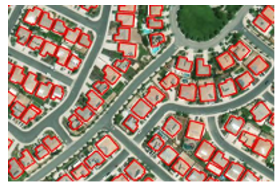
Figure 1. Example of building footprints: each polygon represents the outline of a building as seen from above.
How are they obtained?
There are several ways to generate building footprints:
- From satellite or aerial imagery: using photo-interpretation techniques or, more recently, artificial intelligence and machine learning algorithms.
- With cadastral data or official registers: as in the case of the Cadastre in Spain, which maintains precise vector bases of all registered constructions.
- By collaborative mapping: platforms such as OpenStreetMap (OSM) allow volunteer users to manually digitise visible footprints on orthophotos.
What are they for?
Building footprints are essential for:
- Urban and territorial analysis: allow the study of built density, urban sprawl or land use.
- Cadastral and real estate management: are key to calculating surface areas, applying taxes or regulating buildings.
- Planning of infrastructures and public services: they help to locate facilities, design transport networks or estimate energy demand.
- 3D modelling and smart cities: serve as a basis for generating three-dimensional urban models.
- Risk and emergency management: to identify vulnerable areas, estimate affected populations or plan evacuations.
In short, building footprints are a basic piece of the spatial data infrastructure and, when offered as open, accessible and up-to-date data, they multiply their value and usefulness for society as a whole.
Why are they key in emergency situations?
Of all the possible use cases, in this article we will focus on emergency management. During such a situation - such as an earthquake, flood or wildfire - responders need to know which areas are built-up, how many people can inhabit those structures, how to access them and where to concentrate resources. The building footprints allow:
- Rapidly estimate the number of people potentially affected.
- Prioritise intervention and rescue areas.
- Plan access and evacuation routes.
- Cross-reference data with other layers (social vulnerability, risk areas, etc.).
- Coordinate action between emergency services, local authorities and international cooperation.
Open data available
In an emergency, it is essential to know where to locate building footprint data. One of the most relevant developments in the field of data governance is the increasing availability of building footprints as open data. This type of information, previously restricted to administrations or specialised agencies, can now be freely used by local governments, NGOs, researchers and businesses.
Some of the main sources available for emergency management and other purposes are summarised below:
- JRC - Global Human Settlement Layer (GHSL): the Joint Research Centre of the European Commission offers a number of products derived from satellite imagery analysis:
- GHS-BUILT-S: raster data on global built-up areas.
- GHS-BUILD-V: AI-generated vector building footprints for Europe.
- Downloading data: https://ghsl.jrc.ec.europa.eu/download.php
- IGN and Cadastre of Spain: the footprints of official buildings in Spain can be obtained through the Cadastre and the Instituto Geográfico Nacional (IGN).. They are extremely detailed and up-to-date.
- Download centre of the IGN: https://centrodedescargas.cnig.es
- Cadastral Surveyor: https://www.sedecatastro.gob.es.
- Copernicus Emergency Management Service: provides mapping products generated in record time when an emergency (earthquakes, floods, fires, etc.) is triggered.. They include damage maps and footprints of affected buildings.
- Download centre: https://emergency.copernicus.eu/mapping/list-of-components/EMSR
- Important: to download detailed vector data (such as footprints), you need to register on the platform DIAS/Copernicus EMS or request access on a case-by-case basis.
- OpenStreetMap (OSM): collaborative platform where users from all over the world have digitised building footprints, especially in areas not covered by official sources. It is especially useful for humanitarian projects, rural and developing areas, and cases where rapid updating or local involvement is needed.
- Downloading data: https://download.geofabrik.de
- Google Open Buildings: this Google project offers more than 2 billion building footprints in Africa, Asia and other data-scarce regions, generated with artificial intelligence models. It is especially useful for humanitarian purposes, urban development in countries of the global south, and risk exposure assessment in places where there are no official cadastres.
- Direct access to the data: https://sites.research.google/open-buildings/
- Microsoft Building Footprints: Microsoft has published sets of building footprints generated with machine learning algorithms applied to aerial and satellite imagery. Coverage: United States, Canada, Uganda, Tanzania, Nigeria and recently India. The data is open access under the ODbL licence.
- Meta (ex Facebook) AI Buildings Footprints: Meta AI has published datasets generated through deep learning in collaboration with the Humanitarian OpenStreetMap Team (HOT). They focused on African and Southeast Asian countries.
- Direct access to the data: https://dataforgood.facebook.com/dfg/tools/buildings.
Comparative table of open building footprints sources
| Source/Project | Geographic coverage | Data type | Format | Requires registration | Main use |
|---|---|---|---|---|---|
| JRC GHSL | Global (raster) / Europe (vector) | Raster and vector | GeoTIFF / GeoPackage / Shapefile | No | Urban analysis, European planning, comparative studies |
| IGN + Cadastre Spain | Spain | Official vector | GML/Shapefile/WFS/WMS | No | Cadastral data, urban planning, municipal management |
| Copernicus EMS | Europe and global (upon activation) | Vector (post-emergency) | PDF / GeoTIFF / Shapefile | Yes (for detailed vector data) | Rapid mapping, emergency management |
| OpenStreetMap | Global (varies by area) | Collaborative vector | .osm / shapefile / GeoJSON | No | Base maps, rural areas, humanitarian aid |
| Google Open Buildings | Africa, Asia, LatAm (selected areas) | Vector (AI-generated) | CSV / GeoJSON | No | Risk assessment, planning in developing countries |
| Microsoft Buildings Footprints | USA, Canada, India, Africa | Vector (AI) | GeoJSON | No | Massive data, urban planning, rural areas |
| Meta AI | Africa, Asia (specific areas) | Vector (AI) | GeoJSON / CSV | No | Humanitarian aid, complementing OSM in uncovered areas |
Figure 2. Comparative table of open building footprint sources.
Combination and integrated use of data
One of the great advantages of these sources being open and documented is the possibility of combining them to improve the coverage, accuracy and operational utility of building footprints. Here are some recommended approaches:
1. Complementing areas without official coverage
- In regions where cadastre is not available or up to date (such as many rural areas or developing countries), it is useful to use Google Open Buildings or OpenStreetMap as a basis.
- GHSL also provides a harmonised view on a continental scale, useful for planning and comparative analysis.
2. Cross official and collaborative layers
- The Spanish cadastre footprints can be enriched with OSM data when new or modified areas are detected, especially after an event such as a catastrophe.
- This combination is ideal for small municipalities that do not have their own technical capacity, but want to keep their data up to date.
3. Integration with socio-demographic and risk data
- Footprints gain value when integrated into geographic information systems (GIS) alongside layers such as:
- Population per building (INE, WorldPop).
- Flood zones (MAPAMA, Copernicus).
- Health centres or schools.
- Critical infrastructure (electricity grid, water).
This allows modelling risk scenarios, planning evacuations or even simulating potential impacts of an emergency.
4. Combined use in actual activations
Some real-world examples of uses of this data include:
- In cases such as the eruption on La Palma, data from the Cadastre, OSM and Copernicus EMS products were used simultaneously to map damage, estimate the affected population and plan assistance.
- During the earthquake in Turkey in 2023, organisations such as UNOSAT and Copernicus combined satellite imagery with automatic algorithms to detect structural collapses and cross-reference them with existing footprints. This made it possible to quickly estimate the number of people potentially trapped.
In emergency situations, time is a critical resource. Artificial intelligence applied to satellite or aerial imagery makes it possible to generate building footprints much faster and more automated than traditional methods.
In short, the different sources are not exclusive, but complementary. Its strategic integration within a well-governed data infrastructure is what allows moving from data to impact, and putting geospatial knowledge at the service of security, planning and collective well-being.
Data governance and coordination
Having quality building footprints is an essential first step, but their true value is only activated when these data are well governed, coordinated between actors and prepared to be used efficiently in real-world situations. This is where data governancecomes into play: the set of policies, processes and organisational structures that ensure that data is available, reliable, up-to-date and used responsibly.
Why is data governance key?
In emergency or territorial planning contexts, the lack of coordination between institutions or the existence of duplicated, incomplete or outdated data can have serious consequences: delays in decision-making, duplication of efforts or, in the worst case, erroneous decisions. Good data governance ensures that:
- Data must be known and findable: It is not enough that it exists; it must be documented, catalogued and accessible on platforms where users can easily find it.
- Have standards and interoperability: building footprints should follow common formats (such as GeoJSON, GML, shapefile), use consistent reference systems, and be aligned with other geospatial layers (utility networks, administrative boundaries, risk zones...).
- Keep up to date: especially in urban or developing areas, where new construction is rapidly emerging. Data from five years ago may be useless in a current crisis.
- Coordination between levels of government: municipal, regional, national and European. Efficient sharing avoids duplication and facilitates joint responses, especially in cross-border or international contexts.
- Clear roles and responsibilities are defined: who produces the data, who validates it, who distributes it, who activates it in case of emergency?
The value of collaboration
A robust data governance ecosystem must also foster multi-sector collaboration. Public administrations, emergency services, universities, the private sector, humanitarian organisations and citizens can benefit from (and contribute to) the use and improvement of this data.
For example, in many countries, local cadastres work in collaboration with agencies such as national geographic institutes, while citizen science and collaborative mapping initiatives (such as OpenStreetMap) can complement or update official data in less covered areas.
Emergency preparedness
In crisis situations, coordination must be anticipated. It is not just about having the data, but about having clear operational plans on how to access it, who activates it, in what formats, and how it integrates with response systems (such as Emergency Coordination Centres or civil protection GIS).
Therefore, many institutions are developing protocols for activating geospatial data in emergencies, and platforms such as Copernicus Emergency Management Service already work on this principle, offering products based on well-governed data that can be activated in record time.
Conclusion
Building footprints are not just a technical resource for urban planners or cartographers: they are a critical tool for risk management, sustainable urban planning and citizen protection. In emergency situations, where time and accurate information are critical factors, having this data can make the difference between an effective intervention and an avoidable tragedy.
Advances in Earth observation technologies, the use of artificial intelligence and the commitment to open data by institutions such as the JRC and the IGN have democratised access to highly valuable geospatial information. Today it is possible for a local administration, an NGO or a group of volunteers to access building footprints to plan evacuations, estimate affected populations or design logistical routes in real time.
However, the challenge is not only technological, but also organisational and cultural. It is imperative to strengthen data governance: to ensure that these sets are well documented, updated, accessible and that their use is integrated into emergency and planning protocols. It is also essential to train key actors, promote interoperability and foster collaboration between public institutions, the private sector and civil society.
Ultimately, building footprints represent much more than geometries on a map: they are a foundation on which to build resilience, save lives and improve decision-making at critical moments. Betting for its responsible and open use means betting for a smarter, more coordinated and people-centred public management.
Content prepared by Mayte Toscano, Senior Consultant in Data Economy Technologies. The contents and points of view reflected in this publication are the sole responsibility of the author.


Comments