Noticia
In recent years, we have been witnessing a technological revolution that increasingly pushes us to broaden our training to adapt to the new digital devices, tools and services that are already part of our daily lives. In this context, training in digital skills is more relevant than ever.
Last October, the European Commission, led by its President Ursula Von Der Leyen, announced its intention to make 2023 the "European Year of Skills", including digital skills. The reason lies in the difficulties that have been identified among European citizens in adapting to new technologies and exploiting their full potential, especially in the professional sphere.
The European digital skills gap
According to data provided by Eurostat, more than 75% of EU companies have reported difficulties in finding professionals with the necessary skills to do the job they are looking for. Moreover, the European Labour Agency warns that there is a severe shortage of ICT specialists and STEM-qualified workers in Europe. This is exacerbated by the fact that currently only 1 in 6 IT specialists is female.
When it comes to digital skills, the figures are not flattering either. As noted in the Digital Economy and Society Index (DESI), based on data from 2021, only 56% of the European population possesses basic digital skills, including information and data literacy, communication and collaboration, digital content creation, security and problem-solving skills.
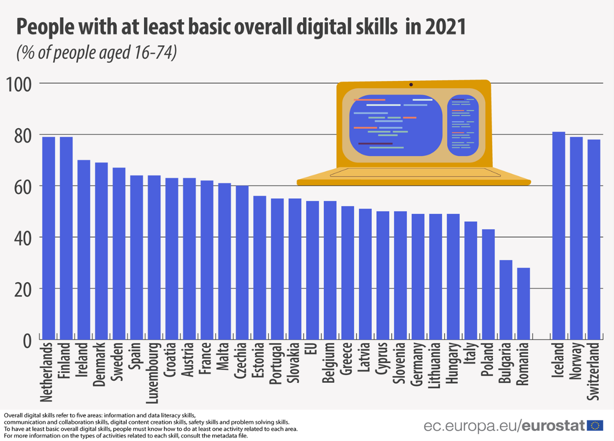
EU citizens with the least basic digital skills by country. Source: Eurostat, 2022.
European initiatives to promote the development of digital competences
As mentioned above, improving education and digital skills is one of the major objectives that the European Commission has set for 2023. If we look at the longer term, the goal is more ambitious: The EU aims for at least 80% of EU adults to have basic digital skills such as those mentioned above by 2030. In terms of the professional sector, the target focuses on having around 20 million ICT professionals, with a significant number of women in the sector.
In order to realise these objectives, there are a number of measures and initiatives that have been launched at European level. One of them stems from the European Skills Agency, whose action points 6 and 7 are focused on improving all relevant skills for the green and digital transitions, as well as increasing the number of ICT graduates.
Through the NextGenerationEU funds and its Resilience and Recovery Mechanism, EU member states will be eligible for support to finance digital skills-related reforms, as €560 million will be made available for this purpose.
In addition, other EU funding programmes such as the Digital Europe Programme (DEP) or the Connecting Europe Facility (CEF) will respectively offer financial support for the development of education programmes specialised in digital skills or the launch of the European Digital Skills and Jobs Platform to make information and related resources available to citizens.
Alongside these, there are also other initiatives dedicated to digital skills training in the Digital Education Action Plan, which has created the European Centre for Digital Education, or in the mission of the Digital Skills and Jobs Coalition, which aims to raise awareness and address the digital skills gap together with public administrations, companies and NGOs.
The importance of open data in the 'European Year of Digital Skills'.
In order to promote the development of digital skills among European citizens, the European open data portal carries out several actions that contribute to this end and where open data plays a key role. Along these lines, Data Europa remains firmly committed to promoting training and the dissemination of open data. Thus, in addition to the objectives listed below, it is also worth highlighting the value at the knowledge level that lies behind each of the workshops and seminars programmed by its academic section throughout the year.
- To support Member States in the collection of data and statistics on the demand for digital skills in order to develop specific measures and policies.
- Work together with national open data portals to make data available, easily accessible and understandable.
- Provide support to regional and local open data portals where there is a greater need for help with digitisation.
- Encourage data literacy, as well as the collection of use cases of interest that can be reused.
- Develop collaborative environments that facilitate public data providers in the creation of a smart data-driven society.
Thus, just as data.europa academy functions as a knowledge centre created so that open data communities can find relevant webinars and trainings to improve their digital skills, in Spain, the National Institute of Public Training includes among its training options several courses on data whose task is to keep public administration workers up to date with the latest trends in this field.
In this line, during the spring of 2023, a training on Open Data and Information Reuse will take place, through which an approach to the open data ecosystem and the general principles of reuse will be carried out. Likewise, from 24 May to 5 June, the INAP is organising another course on the Fundamentals of Big Data, which will address blocks of knowledge such as data visualisation, cloud computing, artificial intelligence and the different strategies in the field of Data Governance.
Likewise, if you are not a public sector worker, but you are interested in expanding your knowledge of open data, artificial intelligence, machine learning or other topics related to the data economy, in the blog and documentation section of datos.gob.es you can find adapted training materials, monographs on various topics, case studies, infographs and step-by-step visualisations that will help you to understand more tangibly the different theoretical applications involving open data.
At datos.gob.es, we have prepared publications that compile different free training courses on different topics and specialisations. For example, on artificial intelligence or data visualisations.
Finally, if you know of more examples or other initiatives dedicated to fostering digital skills both at national and European level, do not hesitate to let us know through our mailbox dinamizacion@datos.gob.es. We look forward to all your suggestions!
Blog
The Commission's drive to promote data spaces within the framework of a European Strategy is based on the firm commitment to a regulatory framework that provides regulatory coherence throughout the Union. In particular, the aim is to establish a solid regulation that offers legal certainty to a model based on respect for rights and freedoms. Thus, initially, two initiatives have been promoted to, on the one hand, establish the regulatory bases of the governance model - already definitively adopted by Regulation (EU) 2022/868 of 30 May - and, on the other hand, to establish harmonised rules on the access and fair use of data throughout the Union.
However, while recognising the importance of the design of this general legal architecture, the effective opening and exchange of data requires a more concrete approach that takes into account the specificities of each sectoral area and, in particular, the difficulties and challenges to be faced. Therefore, taking into account the general regulatory framework referred to above, the Commission has presented the first regulatory initiative for one of these areas, related to health data, which is currently under public consultation and negotiation in the Council of the EU and in the European Parliament, and which is part of the project to create a European health data area.
In particular, beyond facilitating the development of cross-border e-services, the proposal aims to address a triple objective:
• Establish a uniform legal framework to facilitate the development, marketing and use of electronic health record systems by establishing a compulsory self-certification scheme for certain systems, which in any case provides for some exceptions, e.g. general purpose software used in healthcare environments.
• Facilitating patients' electronic access to their own data in the framework of healthcare provision (primary use of health data). In this respect, the proposal seeks to strengthen consistency across Member States in protecting health data irrespective of where the healthcare provision takes place or the type of entity carrying it out.
• Encourage the re-use of such data for other secondary purposes. To this end, a specific governance model is envisaged with a specific body at the head - the so-called European Health Data Space Board - and the deployment of duly coordinated state administrative structures - health data access bodies.
We will look at this last point in more detail below.
The promotion of secondary uses
With regard to the re-use of data for purposes other than health care, the proposed regulation is based on the following evidence: although health data are already being collected and processed using electronic means, in many cases, however, access to them is not facilitated to satisfy other purposes of general interest. For this reason, in general, it is intended to establish a broad regulation that facilitates secondary uses of health data. For example, the elaboration of statistics, the development of training and research activities, such as technological innovation -including the training of algorithms- or personalised medicine.
However, for the purposes of denying access to health data, some secondary uses are expressly declared incompatible, such as:
• The adoption of decisions detrimental to natural persons, meaning not only those that produce legal effects but also those that significantly affect them. In this respect, changes relating to insurance contracts, such as an increase in the amounts to be paid, are specifically highlighted.
• The carrying out of advertising or marketing activities aimed at healthcare professionals, organisations in the sector or natural persons.
• Making data available to third parties that are not covered by the data permission granted.
• The development of harmful products and services, including in particular illicit drugs, alcoholic beverages, tobacco products or goods or services that contravene public order or morality.
With regard to the parties obliged to share data, in principle the proposed regulation extends to those who collect and process data with public funding, who must make them available to the competent bodies for access to health data in order to facilitate their re-use. However, given their importance in some States, the regulation also extends its scope of application to private parties providing health services - except in the case of micro-enterprises - and also to professional associations. Specifically, this regulation would affect "any natural or legal person, which is an entity or a body in the health or care sector, or performing research in relation to these sectors, as well as Union institutions, bodies, offices and agencies who has the right or obligation, in accordance with this Regulation, applicable Union law or national legislation implementing Union law, or in the case of non-personal data, through control of the technical design of a product and related services, the ability to make available, including to register, provide, restrict access or exchange certain data".
Purpose and conditions of access to health data
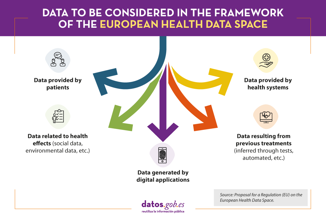
The proposed Regulation is based on a broad concept of health data, which includes the following categories:
The regulation is based on a general rule: access to anonymised data as a measure to reduce privacy risks, although a specific regime is also envisaged for personal data. In this case, the request must include an adequate justification and the data will only be provided in pseudonymised form.
As regards the form of access, the particular sensitivity of health data determines that it is proposed that they should be made available through a secure processing environment that complies with the technical and security standards included in the proposal. In particular, the proposal does not allow that, except for non-personal data, the data are transmitted directly to the person who will re-use them. Furthermore, it provides for processing to take place in secure environments under the control of the access authorities.
Access authorities for health data
From the perspective of the governance model underpinning the proposal, States should have at least one health data access body to provide electronic access to health data for secondary purposes. In the case of multiple bodies due to requirements arising from their political-administrative organisation, one of them will have a coordinating role. Beyond the organisational freedom of the States to choose one or another organisational formula, it is essential that the independence of the coordinating body be guaranteed, without prejudice to the mechanisms of financial or judicial control.
As already indicated, the main purpose of this measure is to ensure a uniform and consistent application of the regulatory framework for access to health data for secondary purposes across the European Union, in particular as regards the protection of personal data in this sector. In this respect, it is proposed that these bodies should be given the powers to verify compliance with these rules and, in particular, to impose sanctions and other measures such as temporary or definitive exclusion from the European Health Data Area of those who do not comply with their obligations.
The harmonisation sought by the proposed Regulation is also envisaged in the establishment of a standardised process for the issuing of permissions to re-use data for secondary purposes. In particular, in cases where anonymised access to the data is not enough, reasons should be given as to why pseudonymised access is necessary. In the latter case, the request must specify the legal basis for requesting access to the data from the perspective of personal data protection law, the secondary purposes for which the data are intended to be re-used, as well as a description of the data and tools necessary for their processing.
Finally, the proposed regulation includes active disclosure obligations addressed to these bodies about the available datasets. This is an essential measure, since the existence of a catalogue of datasets at European level - based on the interconnection of national datasets - would be extremely useful for promoting not only research and innovation but also decision-making at regulatory and political level. Specifically, for each set of available data, the nature of the data, its source and the conditions for making it available will have to be indicated.
In short, this is a certainly innovative initiative to address the regulatory diversity existing in each Member State, which is, however, at an early stage of processing. Precisely, a participation procedure is currently open that allows for the submission of allegations against the initial drafting until 28 July 2022 through a simple procedure accessible via this link.
Content prepared by Julián Valero, Professor at the University of Murcia and Coordinator of the Research Group "Innovation, Law and Technology" (iDerTec).
The contents and views expressed in this publication are the sole responsibility of the author.
Noticia
The current Directive 2019/1024 on open data and re-use of public sector information, adopted in June 2019, was established to replace and improve the former Directive 2003/98/EC. Among its objectives was to boost the availability of public sector data for re-use by establishing some minimum harmonisation rules that favour its use as a raw material for innovation in all economic sectors. It should be noted that this directive has been incorporated into Spanish law through Royal Decree-Law 24/2021, of 2 November, transposing several European Union directives.
Among the most significant changes introduced by Directive 2019/1024 was the drawing up of a list of high-value datasets to be highlighted among those held by public bodies.
High-value data: definition and characteristics
The Directive describes high-value data as "documents whose re-use is associated with considerable benefits for society, the environment and the economy, in particular because of their suitability for the creation of new, decent and quality value-added services, applications and jobs, and the number of potential beneficiaries of value-added services and applications based on such datasets".
This definition provides some clues as to how such high-value datasets can be identified. Identification can be carried out through a series of indicators including:
- Potential to generate:
- Significant social or environmental benefits
- Economic benefits and new revenues
- Innovative services
- Potential in terms of number of users benefited, with a particular focus on SMEs.
- Ability to be combined with other datasets.
How should high-value data be published?
According to the Directive, the publication of these datasets has to meet the following requirements:
- Be reusable free of charge.
- Available through application programming interfaces (APIs).
- Available in a machine-readable format.
- Feature a bulk download option, where possible.
In addition, they should be compatible with open standard licences.
Which thematic categories are considered high-value data?
The European Data Strategy incorporates high-value data as a common data layer that facilitates, together with data from the private sector, the deployment of sectoral data spaces in strategic areas.
Originally, the directive included in its annex a number of priority themes that could be considered high-value data: geospatial data, earth observation and environmental data, meteorological data, statistical data, business registers or transport data.
However, these categories were very broad. The EU has therefore launched an initiative to establish a list indicating more precisely what types of data are considered high-value and how they should be published. Following an extensive consultation of stakeholders and taking into account the outcome of the impact assessment, the Commission identified, within each of the six data categories, a number of datasets of particular value and the arrangements for their publication and re-use.
The list takes the form of a binding implementing act. The granularity and modality of publication varies from one dataset to another, trying to strike a balance between the potential socio-economic and environmental benefits and the financial and organisational burden to be borne by public data holders. Existing sectoral legislation governing these datasets should also be taken into account.
Open comment period on the draft law "Open Data: Availability of public datasets".
The next step is to get citizens' feedback on the proposed datasets. The European Commission currently has a specific section open on its website, at the end of which any citizen of the European Union can provide their comments to help improve and enrich this initiative. The public consultation will run for four weeks, from 24 May to 21 June 2022.
In order to submit your comments, you need to register using your email address or popular social networks such as Twitter or Facebook.
Remember that in order to express your opinion and for it to be taken into account by the public body, your comment must comply with the established rules and standards. In addition, you can consult the comments already made by other citizens from different countries and which are offered publicly. The website also includes a visualisation that presents data on the number of opinions offered per country or the category to which the participants belong (private companies, academic institutions, research institutions, NGOs, citizens, etc.).
This list will be a really important milestone as, for the first time in many years, it will be possible to establish an explicit and common guide on what are the minimum datasets that should always be available and what should be the conditions for their re-use throughout the European Union.
At the Spanish level, the Data Office, in collaboration with stakeholders, will be in charge of landing this list and specifying other additional datasets, both public and private, based on what is indicated in Royal Decree-Law 24/2021.
Noticia
Open Data Day was the date chosen for the launch of the EU Datathon 2021, an event that is now in its fifth edition. Organized by the Publications Office of the European Union within the framework of the EU Open Data Days, seeks to highlight the value of open data and show the opportunities of business models based on it.
Participating teams must create a mobile or web application that responds to challenges related to the priorities of the European Commission, using open data sets.
3 challenges to solve
The available challenges are:
- Challenge 1: ‘A European Green Deal’. The European Green Deal it is the blueprint to drive a modern, sustainable and competitive European economy. Those who choose this challenge will need to develop applications or services aimed at creating a greener Europe, for example by promoting efficient use of resources or reducing pollution.
- Challenge 2: ‘An economy that works for people’. In this case, applications or services aimed at companies, public administrations or citizens in general are sought in order to create a fairer economic and monetary union, which allows the growth of the economies of the member countries together with the reduction of poverty and inequality. This category would include, for example, a solution to boost youth job creation.
- Challenge 3: ‘A Europe fit for the digital age’. The EU aspires to a digital transformation that works for people and businesses. Therefore, this challenge encourages the creation of applications or services that improve data competencies, increase connectivity or make data more understandable for everyone, based on the European Data Strategy.
Each challenge is organized as a separate competition of equal importance.
The solutions presented must combine at least one data set of data.europa.eu (EU Open Data Portal o European Data Portal) with any other publicly available data set.
Who can participate?
It is aimed at citizens around the world who are interested in prototyping products based on public open data and even creating new business models for profit or not for profit through the exploration of such data.
Participation is open to individuals or legal entities, integrated in teams of between one and four members.
Staff working in the institutions, agencies, bodies, partner organizations or contractors of the EU Publications Office cannot register.
How does the competition develop?
Los equipos participantes deben registrar su propuesta siguiendo este formulario antes del 21 de mayo de 2021 a las 23:59 CET (hora central europea). A partir de entonces la competición se desarrollará en 2 fase:
-
Preselection
All proposals will be evaluated by the jury, made up of experts from within and outside the EU institutions and agencies based on a series of criteria such as the relevance of the selected challenge or the potential and creativity of the proposed solution.
For each challenge, a maximum of three teams that have obtained the highest number of points will be shortlisted. All participating teams will receive notification of the results before June 11, 2021.
-
Final phase
Shortlisted teams (three per challenge) will be invited to convert their proposals into applications. In addition, each shortlisted team must produce a 60-second video, in which they present their application and the team working on it, before August 1, 2021.
The final of the competition will take place on November 25. The applications presented in each challenge will be evaluated by a jury made up of at least five experts. In addition to the relevance of the proposal, the open data used (economic and social potential, interoperability with other data sources, etc.) and the adequacy of the objective (product maturity, benefits offered, etc.) will be taken into account.

Which is the prize?
In total, 99,000 euros will be awarded (33,000 for each challenge), which will be divided for each challenge as follows:
- First place: 18,000 euros
- Second place: 10,000 euros
- Third place: 5,000 euros
From datos.gob.es we invite you to submit your proposal. Good luck to all participants!
Blog
COPERNICUS, the Earth observation program of the European Union, is the world's largest geospatial data provider, with a current production of twelve terabytes a day. The possible uses of this data, many of which are made available to citizens for free, are multiple and can have a place in various economic sectors: from promoting political decision-making to improve sustainability or emergency management to optimize transport or agricultural management. Its economic potential is therefore immense. But starting a business that uses this kind of data is not always easy.
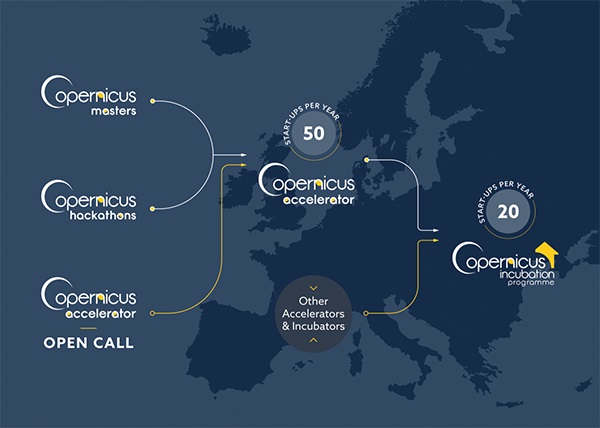
In this context, COPERNICUS START-UP PROGRAMME was born, to help entrepreneurs and new companies to promote new businesses based on the data offered by the Copernicus project. The program consists of four components: prizes, hackathons, acceleration program and incubation program.
- The Copernicus Prizes support the generation of new applications and business ideas. Aimed at entrepreneurs, start-ups and students, they are awarded in the context of the Copernicus Master project. In 2019, participants have had the opportunity to win prizes with a total value of more than 450,000 euros and additional benefits such as coaching, technical support or marketing assistance. To do this, they had to solve a series of challenges posed by partners such as Airbus, the European Space Agency (ESA) or the German Ministry of Transport.
- Copernicus Hackathons are events in which programmers and subject-matter experts collaborate to develop software solutions based on Copernicus data and services that solve global social and economic problems. In this regard, the European Commission funds 20 Copernicus hackatons every year throughout Europe, which can be organized by any organization that is running for it.
- Copernicus Accelerator is a 12-month acceleration program that welcomes 50 new entrepreneurs every year in the European territory. During the program, each participant has the help of a mentor who offers a personalized guide to achieve a commercial objective (for example, participate in an incubator programme or obtaining a first client). The program begins and closes with two BootCamps, where all participants meet their mentor and can expand their contacts network. In addition, participants have at their disposal a virtual training program with new online courses every month.
- Copernicus Incubator is the incubation program for start-ups that are less than 5 years old. Each year, the program grants 50,000 euros to 20 European companies, to finance its consolidation. In 2020, three new rounds of financing will take place in February, May and October.
To these programs we must add other initiatives such as Copernicus Relay and Copernicus Academy. Copernicus Relay is a program made up of organizations that coordinate and promote local activities around the Copernicus program, while Copernicus Academy connects European universities, research institutions, business schools and private organizations from the countries participating in the program, facilitating collaboration between them. You can read more about both programs and the role of Spain in them in this article.
In short, thanks to all these activities, the development of innovative applications and products increase to make the lives of European citizens and other places in the world easier. In the use cases section of the Copernicus website you can see some of the projects carried out based on the information provided by the program, which can inspire you to dare to innovate with the geospatial data provided by Copernicus.
Blog
The new Directive on the opening of data and the reuse of public sector information, which was adopted last June, will replace and improve the old Directive 2003/98 / EC on the reuse of public sector information. Among the most significant changes within this new Directive is the objective of specifying a list of high-value datasets among those held by public sector bodies.
The creation of a list like this is a very important milestone because, for the first time in 15 years of Directive, we will have an explicit and common guide on what are the minimum datasets that should always be available, as well as the conditions for their reuse throughout the European Union - which will include their reuse for free, through application programming interfaces (APIs), in a machine-readable format and, where appropriate, including the bulk download option.
The questions we all ask ourselves immediately are: what are the high-value data they refer to? And what are the specific criteria that we should apply when identifying such high-value data?
The Directive defines high-value data as “documents whose reuse is associated with important benefits for society, the environment and the economy, in particular because of their suitability for the creation of value-added services, applications and new, high-quality and decent jobs, and of the number of potential beneficiaries of the value-added services and applications based on those datasets”. This definition offers several clues as to how these high-value datasets are expected to be identified through a series of indicators that would include:
- Their potential to generate significant social or environmental benefits.
- Their potential to generate economic benefits and new income.
- Their potential to generate innovative services;
- Their potential to benefit a high number of users, in particular SMEs
- Their potential to be combined with other datasets.
On the other hand, the Commission opened a consultation process some years ago that has served to evaluate public opinion on the priority of the data to be published. There are also several studies and reference entities in which the Commission has been inspired and which have been publishing its own recommendations related to high strategic value datasets, such as:
- The results of the MEPSIR study on the exploitation of the information resources of the European Union.
- The technical annex of the G8 Open Data Charter.
- The matters that generate business by the infomediary sector in Spain, according to the analysis of the sector carried out by ONTSI.
- The criteria established by the ISA program of interoperability solutions of the European Commission.
- Standard UNE 178301:2015on Open Data in Smart Cities.
- The data analyzed by the Open Data Barometer and the Global Open Data Index..
- The datasets to be published proposed by the Federation of Municipalities and Provinces - FEMP.
In addition, the Directive itself offers us once again another additional clue in its annex on what datasets could be finally selected for their high-value, through a series of priority domains that largely coincide with the proposals made by the organisms mentioned above: geospatial data, earth observation and environmental, meteorological, statistical, companies records or transport data.

It should also be remembered that the data related to some of the aforementioned topics are also regulated by specific sectoral legislation - such as Directive 2007/2 / EC on spatial data (INSPIRE), Directive 2003/4/EC on environmental information and Directive 2010/40 / EU on transport data - and therefore such legislation should also be taken into account when defining the final scope of application.
However, as the new Directive clarifies, neither the thematic list is closed nor the specific datasets are still defined. And it is that the European Commission has recently commissioned a new impact study precisely with the objective of defining in detail and substantiating what those datasets called “high-value” should finally be. However, there are also critical voices that cry out for the need for a better definition of the analysis criteria when deciding what these data will eventually be, and also for involving the whole society in the process. Fortunately, both critics and the Commission agree that the solution is to broaden the debate and establish a series of public and expert consultations - as is already reflected in the Directive and in the planned impact study - such as case of the debate that will take place in the next edition of the Aporta Meeting on December 18 in Madrid and whose motto is precisely “Driving high-value data”.
Therefore, we will still have to wait for some time until all the studies and consultations planned are completed in order to finally know in detail what will be the high-value data of mandatory publication in the European Union, although it will surely be with sufficient margin before finalizing the deadline for the Directive transposition in July 2021.
Content prepared by Carlos Iglesias, Open data Researcher and consultan, World Wide Web Foundation.
Contents and points of view expressed in this publication are the exclusive responsibility of its author.
Blog
Geospatial data is one of the data categories most demanded by organizations, companies and citizens. The new European regulation on open data and reuse of public sector information considers them as high-value data, due to its ability to boost innovative services and generate socio-economic benefits in multiple sectors of activity.
When we talk about geospatial data, one of the main sources of data that comes to mind is COPERNICUS, the Earth observation program of the European Union.This program is led by the European Commission, with the collaboration of member states and various European agencies and organizations, such as the European Space Agency (ESA) and the European Environment Agency (EEA).

What is the Copernicus program?
Under the slogan “Europe's eye on Earth for the ultimate benefit of European citizens”, Copernicus collects, stores, combines and analyzes data obtained through two sources:
- Data obtained from satellite observation, through the constellations of Sentinel satellites and other third-party satellites.
- Data obtained by land, air and maritime in-siue sensor systems.
These data are organized through 6 servicesthat facilitate access to data and information: emergency, security, marine, land, climate change and atmosphere.

Based on these services, Copernicus has become the largest geospatial data provider in the world, with a current production of twelve terabytes per day. Most of these data - with the exception of those that may compromise citizen security - are provided free of charge and full through the DIAS services (cloud platforms that provide centralized access to Copernicus data and information) or through conventional data platforms.
This information is essential for decision-making in the new electronic government and digital economy systems, covering areas such as management and monitoring of sustainability, climate change and environment, transport, urban agenda and smart cities, security, emergency and catastrophe management, agriculture, energy and natural resources or blue economy, among many others. These data can also be combined with the data obtained through the GALILEO program,the European radionavigation and satellite positioning system. In this way, new opportunities for the public and private sector can be generated, while working towards the achievement of sustainable development goals.
The role of the Ministry of Development in the Copernicus Program
The Ministry of Development participates in the European Earth Observation Program COPERNICUS,as a national representative in various committees and forums, in addition to actively contributing to the provision of free and open data and services. Among others, it collaborates with the territory and marine services, through the D.G. of the National Geographic Institute (IGN) and State Ports.
Specifically, the IGN Territory Observation Unit exercises national representation, together with the Ministry for Ecological Transition (MITECO), in the Copernicus User Forum, for the monitoring and evolution of the program according to user requirements. The User Forum is the working group created to assist the Copernicus Committee to determine user requirements, verify service compliance and coordinate users in public sector. In turn, the Copernicus Committee in Spain is constituted by the Ministry of Industry, Commerce and Tourism and the Centre for Technological and Industrial Development (CDTI).
The IGN is also responsible for the national coordination of the Copernicus (Land) Service and the In Situ; Component; leads the European group of experts Copernicus In Situ EIONET Expert Group; and participates in the Copernicus Coordination Action Framework Program as a National Land Use Reference Center for the 2017-2021 period and the Copernicus User uPtake Framework Program (FP-CUP): 2018/2020.
In addition, it collaborates in the dissemination activities of the Copernicus Program in our country, such as Copernicus Relay and Academy.
Copernicus Relay y Academy
One of the purposes of the Copernicus program is to boost the economic opportunities of geospatial data. Through awards, hackathons, accelerators, e incubators, Copernicus want to help companies develop innovative ideas based on the reuse of the data they provide.
In addition, a set of networks called Copernicus Relay and Academy. were created in the first quarter of 2017to ensure some of the needs that the Copernicus program requires.
- Copernicus Relay
The Copernicus Relay are a group of organizations that coordinate and promote activities around the Copernicus program for local users and administrations in the field of Territory Observation. Its objective is to make known in Europe and outside Europe that Copernicus is a sustainable source of full, free and open information that meets the needs of national, regional and local public services, and that can function as a reinforcement for the development of services.
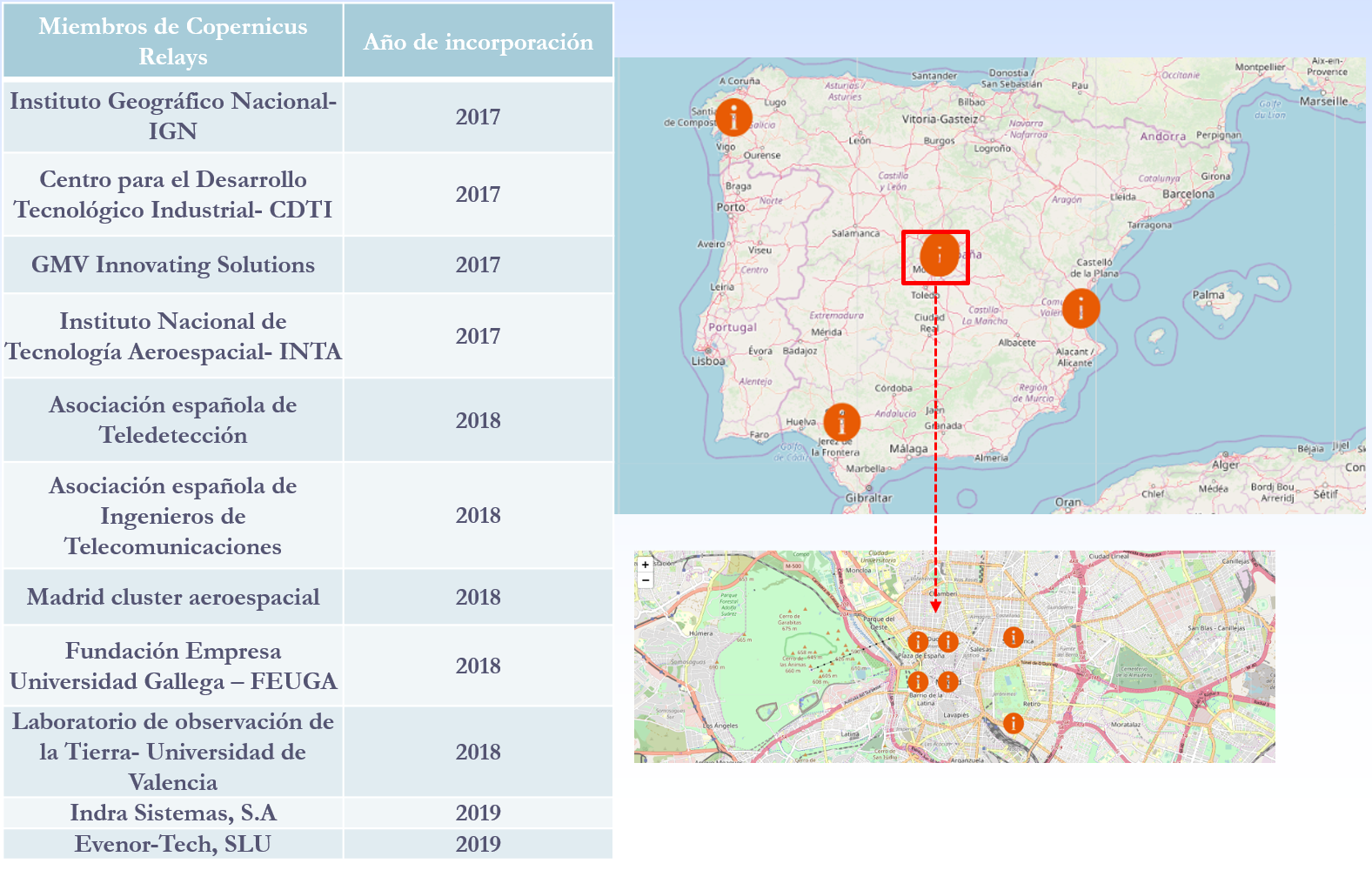
There are currently a total of 85 European Relay members of which 11 are Spanish. The IGN has been a member of Copernicus Relay since 2017.
The possible actions that can be developed by Copernicus Relay members are, among others:
- Coordinate activities at the local level
- Distribute Copernicus dissemination material.
- Inform about what Copernicus is and answer user questions.
- Perform and promote events to publicize Copernicus.
- Organize courses
Any organization that is well connected with user communities, such as private companies, research centers, universities and end users of the public or private sector, can participate. To be a member of Copernicus Relay it is necessary to make a request on this website.
- Copernicus Academy
The Copernicus Academy connect European universities, research institutions, business schools and private organizations of the countries participating in the program and beyond. The objective of the network is to link academic and research institutions with authorities and service providers, facilitating collaborative research and the development of conferences, training sessions and internships. It also provides educational and training material for researchers, scientists and entrepreneurs.
Copernicus Academy also works to increase ideas and good practices sharing across borders and disciplines, while contributing to the development of the use of Earth Observation data in general and Copernicus data and information in particular, in various organizations or industries of public or private users.
There are currently a total of 17 Academy members in Spain.
In short, through these and other initiatives it is expected that an increasing number of users will know the Copernicus program and boost the economic and social opportunities that it entails. Thanks to the accurate, up-to-date and easy-to-access information of the Copernicus program, we will be able to know our environment better, and make decisions that guarantee the future of all European and other regions citizens.
Content prepared based on information by Nuria Valcárcel, Deputy Assistant Director, D.G. National Geographic Institute. Ministry of development.
Noticia
Starting a business is not always easy: according to Fortune, 90% of start-ups fail and only 10% achieve success. The reasons are varied, starting because the market does not need the product or service offered. But, although having a brilliant idea, the lack of human and economic resources can lead any company to failure.
In this context, acceleration programs are especially important, as they help new companies to access financing and support services, as well as to obtain relevant contacts to establish alliances. But it is not always easy to keep up to date with new opportunities.
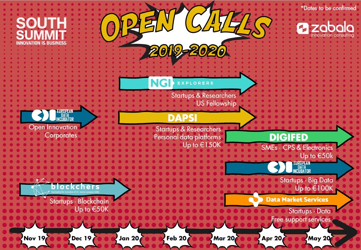
In datos.gob.es we have already informed of some calls, such as those organized by Parsec or Corresolab. Today we focus on 4 financing programs aimed at boosting the European entrepreneurship ecosystem based on data and managed by Zabala Innovation Consulting Group, a consulting firm dedicated to the integral management of grants, subsidies and R&D projects. Zabala acts as a manager in the cascade funding programs of the European Commission, coordinating and distributing the funds of the European innovation programs for start-ups and microenterprises. You can learn more about how cascade funding works in this video.
Next, the main programs focused on data that Zabala manages are detailed:
DATA MARKET SERVICES
Data Market Services supports 50 new companies focused on data every year.
- What does it offer? Free support services in acceleration, fundraising, standardization, legal aspects, intellectual property, promotion and data competencies.
- Who is it for? SMEs and startups across Europe with data-based business models.
- Dates: The 2019 call has ended (here you can see the selected companies), so you have to wait for the 2020 call, which will be open from March to May.
- More information: https://www.datamarketservices.eu/
EUROPEAN DATA INCUBATOR (EDI)
EDI (European Data Incubator) is an 8 month incubation program focused on commercial products and services that make use of at least one set of data or resource provided by EDI itself.
- What does it offer? Free technical and commercial services to develop an MVP (minimum viable product) and reach commercial or investment agreements with data providers, companies and private investors. Teams selected can receive up to € 100,000 of investment in non-refundable funding.
- Who is it for? SMEs, startups and entrepreneurial teams focused on Big Data in Europe.
- Dates: The call for start-ups will open in March 2020, although there is currently a call for suppliers that want to participate in the selection of start-ups and take advantage of investment opportunities.
- More information: https://edincubator.eu/
DAPSI
Dapsi encourages advanced research in the field of data portability, one of the priorities of the European Commission. Initially they select 58 teams, which will have to progress through 3 phases in a 10 month incubation program.
- What does it offer? Access to training and tutoring, business training services and data-related issues, as well as collaboration to enhance higher visibility and alliances with other organizations. In addition, each team will receive up to € 195,000 of non-refundable funding.
- Who is it for? SMEs, startups, research centers, universities across Europe and individuals that develop projects focused on data portability.
- Dates: The project has just started in November and will run until 2022. The first call is estimated to open in January 2020.
- More information: https://cordis.europa.eu/project/rcn/225826/factsheet/en?WT.mc_id=RSS-Feed&WT.rss_f=project&WT.rss_a=225826&WT.rss_ev=a
NGI EXPLORERS
NGI Explorers is a scholarship program with US entities. The objective is that European entrepreneurs and researchers with talent in disruptive technologies (data management and analysis, 5G, Internet of Things, blockchain, etc.) stay 3 or 6 months in a reference entity in the United States.
- What does it offer? Financial support for travel and stay in the United States (up to € 27.9k per person).
- Who is it for? EU researchers and innovators.
- Dates: The next call will be open in the first quarter of 2020.
- More information: https://explorers.ngi.eu/
OTHER PROGRAMS
Zabala also manages the Blockchers program, which offers financing, training and technical infrastructures to build real use cases of blockchain technologies, and the DigiFed program, which aims to boost SMEs, clusters, innovation experts, universities and public bodies that can help reach a new era of digitalization of European industry.
In short, with these programs the European Union, with the help of Zabala, tries to boost innovation and entrepreneurship around data. A fundamental issue to be able to develop a European data economy that is estimated to generate around 739,000 million euros in 2020. It is therefore a field with great business opportunities.
Noticia
One of the main difficulties in promoting the reuse of public sector information refers to the diversity of licenses. Given the absence of a general obligation, each public entity can decide the legal conditions to access for subsequent reuse taking into account the legal preference for open licenses, establishing the minimum possible restrictions.
In any case, there are no clear guidelines on how to use licenses, so that each entity could establish the conditions without having to resort to said instrument. Nor is there an unequivocal legal criterion that allows public entities to choose a certain type of license over another; which ultimately implies that the decision is normally based on criteria of opportunity or, where appropriate, based on the prior conditioning of the document management carried out internally by the entity (support in which it is carried out, formats used, respect for the interoperability rules ...).
Based on these premises, it is of great importance to establish specific criteria for the adoption of such decisions, in particular through the approval of a legal norm in the strict sense. This is the case, for example, in the field of the General State Administration, where some general rules for the provision of data have been established by regulation and, likewise, the preference for openness without conditions has been established unless there is an adequate motivation to justify the option for a reuse regime subject to them. Although already non-normative, one can also opt for the establishment of mere guidelines that, although lacking in strict force, can certainly be useful for making general preferences known in each administrative area.
This problem is reproduced and even multiplied if we project it in Europe. Indeed, although the new Directive 1024/2019 has established specific rules on the use of licenses, the truth is that it leaves a wide discretion to the Member States when they approve their own rules since, in addition to simply urging them to encourage use of type licenses, only establishes a mere obligation to ensure (Article 9.2)
because the type licenses for the reuse of public sector documents, which may be adapted to respond to specific applications of the license, are available in digital format and can be processed electronically.
Consequently, Member States are free to only establish conditions without using licenses; configure their own license adapting to specific measures; or, where appropriate, contemplate the use of type licenses. However, in the absence of the aforementioned guidelines and standards, in principle there will be no objective and predetermined criteria for setting the conditions for access and reuse of information, which would affect not only the public entities themselves but, in particular, those who aim to promote a specific project based on reuse, already for commercial purposes and with a political-social objective. Even more when finding that there can be multiple alternatives depending on the way in which the various criteria that can be taken into account are combined. Specifically, beyond the necessary attribution of authorship - recognition - it would be necessary to assess, among other circumstances, whether or not commercialization is allowed; if in the latter case the power of dissemination is conferred under the same legal conditions in which the data is provided; or, without exhaustive spirit, if modifications, adaptations or even translations are admitted as a result of data processing.
To cope with this difficulty, multiple studies and explanations have been prepared that, both from an academic perspective and, also, from a decided practical approach, are intended to help understand the scope of each type of license, which is especially interesting when the analysis attempts to systematize the existing practice in each of the States of the European Union. However, normally such instruments suffer from an excessively rigid approach, which hinders their use and limits their usefulness, hence the importance of promoting dynamic initiatives that effectively facilitate the understanding of the scope of each of the various types of licenses.
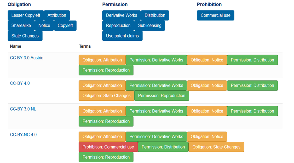
This is precisely the added value of the licensing assistant that has launched the European Data Portal. It is a tool that allows you to carry out advanced adjustments that combine, on the one hand, the choice of specifications and conditions of use and, on the other hand, it offers systematized information in very intuitive formats, such as color assignment or provision of clear and easy to understand information through summary sheets.
Specifically, the assistant allows you to make multiple advanced assignment settings by combining three criteria:
- The obligations that the license entails, an element that in turn articulates from several sub-criteria (lesser copyleft, attribution, sharealike, notice, copyleft and status changes).
- The permission granted, a criterion that is also systematized according to five more precise options (derivative works, distribution, reproduction, sublicensing and use patent claims).
- The prohibition or authorization of commercial uses of the data.
All these criteria can be activated in the configuration chosen when using the assistant, so you can search for those licenses that incorporate only one of them or several. It is also possible to activate in each search elements belonging to each of the main criteria, two of them or, also, to those included in three of them, according to the degree of precision indicated in each assumption. In any case, if several search criteria were legally incompatible with each other, no result would be obtained, which allows an intuitive and efficient exploration of all the possibilities of existing licenses for a specific case from searches that, otherwise, would certainly be complex.
In addition, the assistant allows to link each type of license with a summary sheet where the limitations and possibilities of each type of license are presented in a simple and easily to understand way. Even, in addition to indicating the possibilities, obligations and prohibitions assigning intuitive colours to each alternative, sometimes a succinct explanation is included to facilitate the understanding of each of the alternatives. Finally, each of the cards allows linking to the rest of comparable licenses, so that it is possible to perform that analysis in a simple way.
Even if some advanced functions could be added, such as linking licenses with specific initiatives and projects that are using this type to facilitate their understanding or even incorporate a greater depth of analysis highlighting the main advantages and disadvantages of each type license, the truth is that it is an instrument of unquestionable added value when exploring potential configurations of the conditions of use through licenses by public authorities; who, in addition, can go to the assistant to project multiple simulations when deciding the specific type of license to choose in each case based on diverse criteria.
With regard to reusers, the tool facilitates the effective understanding of each type of license, helping to determine what are the obligations assumed and the limitations to information treatments.
In short, the assistant is undoubtedly a remarkable effort in facilitating the interoperability of licenses in legal terms that, without a doubt, can serve as a basis for more complete future initiatives such as the one being promoted within the framework of the platform Joinup, where a suggestive initial working document has already been generated.
Content prepared by Julián Valero, professor at the University of Murcia and Coordinator of the Research Group "Innovation, Law and Technology" (iDerTec).
Contents and points of view expressed in this publication are the exclusive responsibility of its author.
Evento
Earth Observation data have great potential to create new innovative products and services, an issue that the European Union wants to promote. Therefore, within the Horizon 2020 program, the Parsec accelerator has been launched. Parsec will allocate 2.5 million euros to transform ideas into solutions that take advantage of the potential of this type of data.
The project is developed in connection with the Copernicus program and in collaboration with the European Space Agency and 9 entities from 7 countries, such as Avaesen (Valencian Association of Energy Sector Companies).
The project began in May and will last for 30 months. SMEs, start-ups, entrepreneurs and researchers from member countries of the European Union and associated countries can participate. They only need one idea related to some of the following areas:
• Food: smart agriculture, food security, distribution, etc.
• Energy: renewable energy, Smart Cities, infrastructure monitoring, gas, oil, etc.
• Environment: water and air quality, climate change, forestry, marine resources, etc.
Those interested in participating must submit their idea before December 20, 2019 through the following form. To do this, they must prepare a video of no more than 3 minutes in which they talk about their skills and their vision of innovation.
From then on the project will be developed in two phases:
- Phase 1: After a period of self-evaluation (the applicants themselves are those who evaluate the other applicants through a peer-to-peer application) 100 projects will be chosen, which will receive 10,000 euros each. In addition, the finalists can benefit from a support program that includes personalized training with European experts, coaching, networking with potential clients and partners, and tools to boost the business.
- Phase 2: In the second phase, 15 projects will be selected, which will receive 100,000 euros of funding each. In addition, those selected will have access to tools for testing developed products and the possibility of contacting specialized investors.
These phases will be developed according to the following calendar:
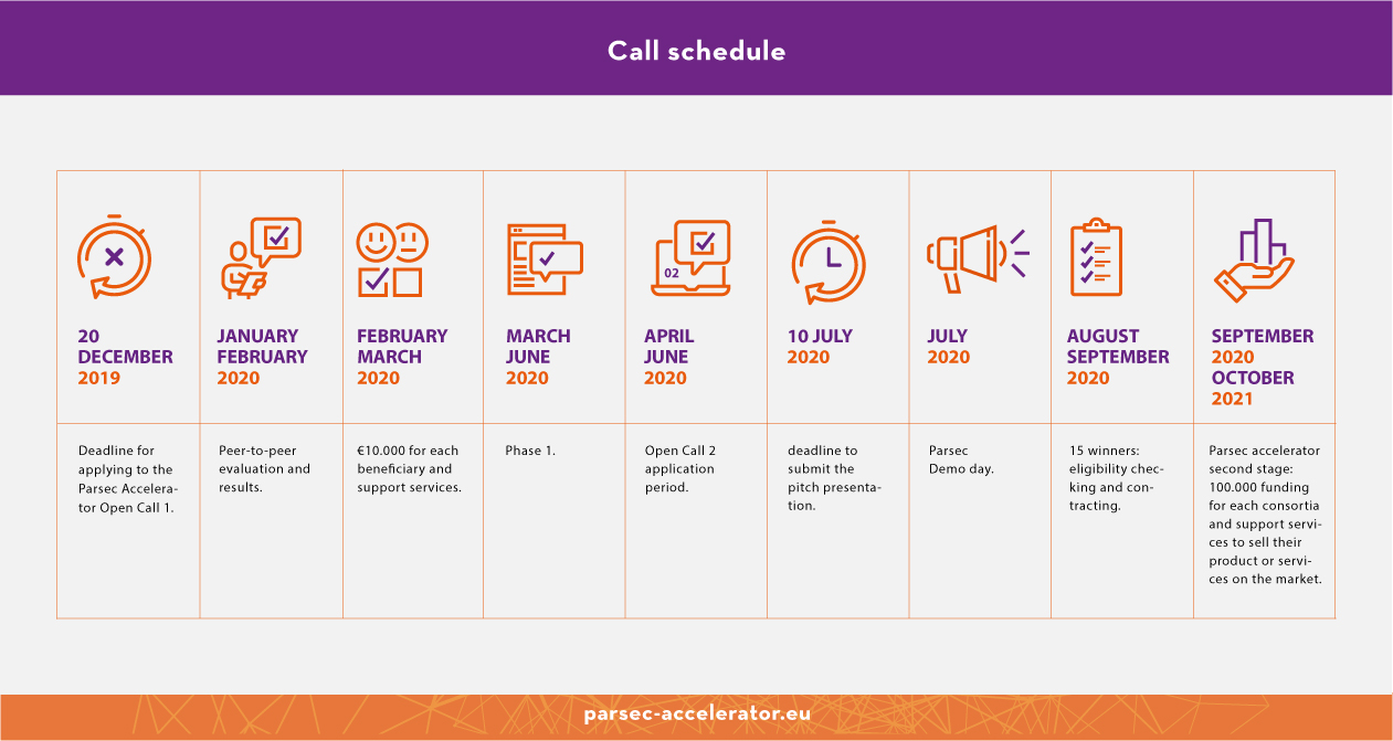
In addition to supporting SMEs and startups that use satellite data for business innovation, this project also seeks to create a community that remain once the call is finished, and that helps promote the international competitiveness of European remote sensing companies through the collaboration between groups. Therefore, many of the tools created will remain active once it is finished.
If you wish to participate, you can find the complete information in the Guide for applicants.