5 posts found
GeoPackage in INSPIRE: efficiency and usability for geospatial data geospatial data.
In the field of geospatial data, encoding and standardisation play a key role in ensuring interoperability between systems and improving accessibility to information.
The INSPIRE Directive (Infrastructure for Spatial Information in Europe) determines the general rules for the establishment of an Inf…

A common language to enable interoperability between open dataset catalogs
Open data plays a relevant role in technological development for many reasons. For example, it is a fundamental component in informed decision making, in process evaluation or even in driving technological innovation. Provided they are of the highest quality, up-to-date and ethically sound, data can…

Why should you use Parquet files if you process a lot of data?
It's been a long time since we first heard about the Apache Hadoop ecosystem for distributed data processing. Things have changed a lot since then, and we now use higher-level tools to build solutions based on big data payloads. However, it is important to highlight some best practices related to ou…
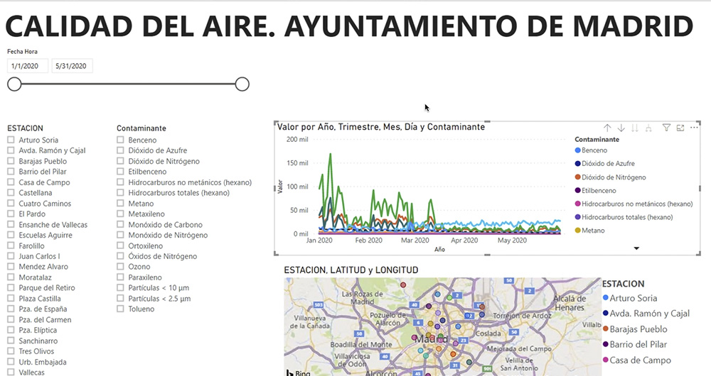
What is an interactive display? Here is an example
The visual representation of data helps our brain to digest large amounts of information quickly and easily. Interactive visualizations make it easier for non-experts to analyze complex situations represented as data.
As we introduced in our last post on this topic, graphical data visualization is a…
Applications of [open] data science for agriculture
In many areas, there is a false belief that the primary sector is a technologically backward sector that is not involved in digitization. Perhaps because throughout history, as economic development indicators progressed, their weight in GDP and employment rates has been decreasing in favor of other…
