
Description
Imagine that you are an urban planning technician and you have an application for a building permit on your table. You have the building plan in one system, the cadastral data in another, the urban planning regulations in a PDF and the map of protected areas in a different viewer. Each check requires jumping between tools, cross-referencing data manually and waiting days or weeks for the process to move forward. Now imagine that all this happens automatically, in real time, with open data and interoperable standards. That, in essence, is what GeoBIM promises.
GeoBIM is much more than a solution for building permits. It is a new way of understanding and managing the territory, buildings, infrastructures and urban services, putting into dialogue two worlds of data that for decades have evolved with their backs to each other, as we will see below. In this article we explore what GeoBIM is, what use cases it opens up, what technical and organizational challenges it presents and what the international standardization community is doing to solve them.
Two worlds, one territory
It all starts from a simple observation: buildings and cities are inseparable, but the data that describe them have historically lived separately.
- Geospatial data (GIS, Geographic Information Systems) describes the territory. It is georeferenced information: cadastral plots, zoning boundaries, infrastructure networks, environmental protection zones, digital terrain models, orthophotos, mobility data... It is the data that tells where things are and how they relate to their environment. In our blog we have already talked about the value of this data; according to a study by the European Open Data Portal, geospatial data is the second most reused, only behind statistical data.
To learn more about how they are published and consumed in Spain, we recommend reading our Practical Guide to the Publication of Spatial Data.
- BIM (Building Information Modelling) data describes buildings. They detail what a building is and how it is constructed, from design to operation and maintenance. They are three-dimensional digital models of enormous semantic richness: they allow us to know what each element is, what material it is made of, what its dimensions are, what it is for, what relationships it has with others, etc. Its reference format is the IFC (Industry Foundation Classes, ISO 16739), an open standard for the exchange of models between different tools.
The integration of both worlds – that is GeoBIM – raises a seemingly simple and technically complex question: how do you get a building model to know where it is in the world and, at the same time, for a city map to know in detail what is inside each building? The Spatial Data Infrastructure of Spain (IDEE) is precisely the ecosystem where this reference geospatial data lives and is published, and its integration with BIM data is the central challenge of this article.
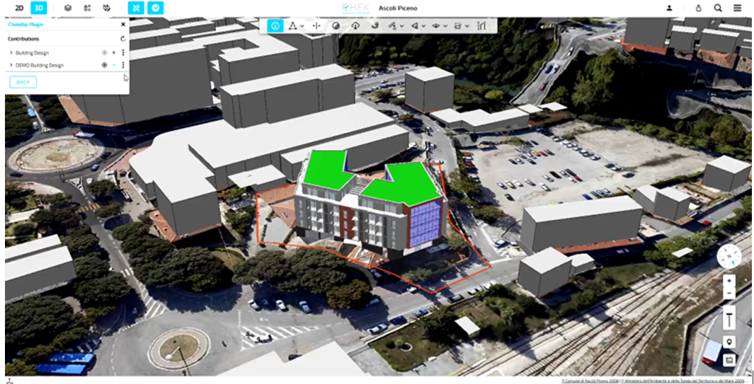
Figure 1. Example of Geo and BIM data integration. Source: CHEK Project
The technical challenge: why it's not trivial
The gap between GIS and BIM is not just organizational. It is deep on a technical and conceptual level:
- Coordinate systems are different. GIS data works on global geodetic reference systems (such as ETRS89 in Europe or WGS84 on GPS). BIM models work on local coordinate systems relative to the building itself. Georeferencing a BIM — anchoring that local system to the global geodetic system — is the first essential step for any integration.
- The levels of detail are incompatible. Geospatial urban information standards – mainly CityGML and its lighter variant CityJSON, developed by the OGC and the academic community respectively – define several levels of detail (LoD): from the simple footprint of the building as a polygon to the representation of facades, windows and balconies. These formats describe the city as context: its geometry, its uses, its relationship with the environment. The IFC, on the other hand, usually works at a much higher level of interior detail, describing each wall, installation and space with its physical and semantic properties. The conversion between the two worlds involves decisions about what to simplify and how to map concepts that have no direct equivalent.
- Semantic models are heterogeneous. A "room" in IFC is an IfcSpace. A "room" in a municipal cadastre is a polygon with specific attributes. A "land use" in INSPIRE is a class with its own taxonomy. Cross-referencing these semantics requires correlation tables that the community is painstakingly building.
- The time scales do not coincide. Cadastral or planning data is updated in cycles of months or years. BIM models evolve throughout the life of the building. Synchronizing both cadences is a data governance challenge.
The Standards Ecosystem
The interoperability between BIM and GIS does not start from scratch. There is a consolidated ecosystem of international standards that defines how data should be structured, exchanged and used. The main ones are summarized below:
|
Standard / Initiative |
What it brings (in one sentence) |
| ISO/TR 23262:2021 |
It identifies the main barriers between BIM and GIS and defines the roadmap for their interoperability. |
| ISO/TS 19166:2021 (B2GM) |
It establishes the conceptual framework for transferring information from BIM to GIS. |
| ISO 19650 |
It defines how to manage BIM information throughout the asset lifecycle. |
| ISO 16739-1:2024 (IFC) |
It allows the exchange of models, including improvements in georeferencing. |
| OGC CityGML 3.0 |
It facilitates the standard representation of cities in 3D with semantic information. |
| OGC – buildingSMART Roadmap |
This is a joint strategy to move towards BIM-GIS interoperability. |
| INSPIRE + OGC API |
They provide harmonized geospatial data and APIs for interoperable consumption. |
Figure 2. Summary table of initiatives and standards in the geospatial field
Use Cases: Beyond Building Permits
Of the various existing use cases, building license automation is the most visible, but GeoBIM has a much broader scope. The following visual shows some examples, which we detail below.
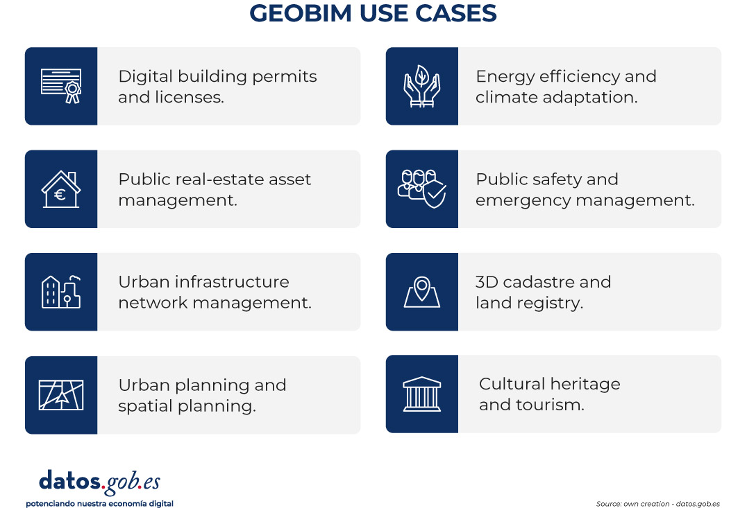
Figure 3. GeoBIM use cases. Source: own elaboration - datos.gob.es
-
Digital Building Permits and Licenses
The processing of construction permits is the use case that has received the most attention in European pilot projects. The current process — fragmented, manual, subject to interpretation — can be radically transformed. The flow with GeoBIM would be: the developer presents his project in georeferenced IFC format. The system automatically crosses it with open geospatial data — cadastre, urban planning in INSPIRE, environmental protection zones, historical heritage — accessed via OGC API. A semantic validation engine, using rules coded in formats such as SHACL, checks dozens of requirements in parallel: minimum separations from boundaries, maximum height, plot occupation, compatibility with land use, impact of shadows on adjacent properties, universal accessibility, proximity to protected areas, etc. The result is a 3D compliance report where each non-compliance is pointed out and linked to the corresponding regulatory article.
The European project CHEK ("Change Toolkit for Digital Building Permit") is one of the most advanced in this field. Thanks to it, concrete GeoBIM integration tools have been developed. Estonia already implements digital permit processing systems with proven results in efficiency and transparency.
-
Management of public real estate assets
Administrations manage huge building stocks – schools, hospitals, offices, sports facilities – whose maintenance, energy efficiency and regulatory compliance require combined information on urban scale and interior detail. GeoBIM allows a digital inventory where each public building exists as a BIM model linked to its geospatial context: what plot it occupies, what regulations apply to it, what networks it has in the environment, what is its georeferenced energy certification, etc.
-
Urban infrastructure network management
Supply networks — water, sanitation, electricity, telecommunications, gas — are perhaps the use case with the greatest operational impact. A GeoBIM digital twin of urban infrastructures makes it possible to precisely locate each conduit, see what surrounds it, and plan interventions without surprises. Canal de Isabel II, for example, is working on the integration of as-built BIM models with IoT (Internet of Things) sensors on its drainage network to create a digital twin capable of anticipating anomalous behavior in the event of heavy rainfall.
-
Urban planning and spatial planning
GeoBIM adds the interior dimension of the buildings to the urban analysis. How many residents will be left without sufficient sunlight if this tower is approved? How many additional school facilities will be needed in the new neighbourhood? How will the new metro line affect the value of the land in the environment? Questions that today require laborious studies can be answered more quickly and rigorously when BIM models are integrated with geospatial planning data.
-
Energy efficiency and climate adaptation
The combination of BIM data (materials, thicknesses, installations) with geospatial data (solar radiation, wind, outside temperature, façade obstructions) makes it possible to accurately calculate the energy performance of buildings in their real context. At the neighbourhood or city level, these analyses make it possible to prioritise refurbishment actions, model the impact of different strategies and estimate the solar generation potential of an urban area – essential for the energy transition required by the Energy Performance of Buildings Directive (EPBD).
-
Public safety and emergency management
Emergency services need detailed information about the interior of buildings when an incident occurs. GeoBIM makes it possible to build systems where the control centre can access the BIM model of the affected building – with information on facilities, materials and layout – overlaid on the operational map of the intervention. Several Nordic countries are already exploring the integration of BIM models of buildings into emergency services CAD systems.
-
3D Cadastre and Land Registry
The current cadastre works mainly in 2D. With the proliferation of buildings with overlapping uses, basements, overhangs, concessions and easements in 3D, their limitations are growing. GeoBIM opens the door to the 3D cadastre: a representation where each real estate unit exists in its real volume. In Spain, the Cadastre Electronic Office already offers services in INSPIRE formats and downloadable data that are a first step.
-
Cultural heritage and tourism
BIM models of historic buildings — combined with geospatial data of the environment and heritage collections — enable digital twins of cultural heritage with multiple uses: documentation and conservation, immersive virtual tours, restoration planning, disaster risk assessment. BIM heritage models (HBIMs) incorporate rich historical, constructive, and archaeological information.
A specific example: the case of the Barcelona Metropolitan Area
When we talk about GeoBIM in Spain, the Barcelona Metropolitan Area (AMB) is one of the most concrete and advanced benchmarks.
The AMB manages the territory of 36 municipalities and has a reference geospatial data infrastructure: the Metropolitan Topographic Map 1:1000 (MTM-1M), a continuous three-dimensional cartographic base prepared and updated in coordination with the Cartographic and Geological Institute of Catalonia (ICGC) and the Barcelona Provincial Council.
In 2023, the AMB published in beta version the BIM models of the metropolitan territory in IFC format, available on its Cartography Geoportal. This product, the result of the joint work of the Cartography Section and the BIM Office of the AMB, converts precision topographic cartography into IFC models that professionals in the AEC (architecture, engineering and construction) sector can integrate directly into their BIM projects.
The declared objective is twofold: for BIM professionals to have a 3D cartography of the environment of their projects with the rigor of the official cartographic bases; and to give territorial continuity to BIM projects within the metropolitan area. The use cases that the AMB highlights are those that define the heart of GeoBIM: sunlight and shade studies, georeferencing checks of projects, lighting studies and visibility analysis.
All the data from the AMB Mapping Geoportal is distributed under a Creative Commons CC BY 4.0 license, which allows it to be reused for any purpose, including commercial, just by citing the source. An exemplary model of data openness for the data economy.
Barcelona City Council itself has the GeoportalBCN, which offers the three-dimensional model of built volumes, interoperable cartographic services and access to its municipal IDE.
The remaining challenges
Despite the enthusiasm and advances, GeoBIM integration faces real barriers that explain why it is not yet a daily practice. Identifying them honestly is necessary to address them.
- IFC georeferencing is a limitation: although IFC 4.3 improves georeferencing capabilities, most of the BIM models in circulation are in older versions, with inconsistent or absent georeferencing.
- IFC–CityGML semantic conversion involves losses: automated conversions between IFC and CityGML involve inevitable losses in both directions. Concepts are not mapped one by one. Current tools make approximate conversions, sufficient for many use cases, but not for all. The IDS (Information Delivery Specification), the buildingSMART standard, is a key tool for improving the quality of input BIM models, although it also has current expressiveness limitations recognized by the CHEK project itself, mentioned above.
- Open geospatial data does not always have the quality that GeoBIM needs: for automatic validation systems to work, the geospatial reference data – cadastre, planning, protection zones – must be in interoperable, up-to-date formats with sufficient semantic detail. In Spain, progress in opening up geospatial data is remarkable, as reflected in the analysis of the value of open geographic data, but the heterogeneity between autonomous communities and municipalities is significant. Urban planning is still published in many administrations in PDF format or in proprietary formats that are difficult to consume by machines.
- Workflows and professional culture are fragmented: BIM and GIS are disciplines with different professional communities, different backgrounds, and different tools. GeoBIM integration requires professionals who understand both worlds — or multidisciplinary teams that collaborate seamlessly. That culture is not yet widespread.
- The governance of shared data: when a BIM model crosses organisational boundaries – from the developer to the town hall, from the town hall to the land registry, from the land registry to the water network manager – governance questions arise: who is the owner? These questions have no technical answer; they require data governance frameworks that administrations are beginning to build.
The role of open data
GeoBIM is, at its core, a technology that is powered by open and reusable data. Without the substrate of quality, structured, up-to-date and openly licensed geospatial data, the GeoBIM building has no foundation.
The cadastral data from the Cadastre Electronic Office, the cartography of the National Geographic Institute (IGN), the BIM models of the territory published by the Barcelona Metropolitan Area (AMB) or the Institut Cartogràfic i Geològic de Catalunya (ICGC), the urban planning data harmonized under INSPIRE — all are pieces of the puzzle that, together, make the GeoBIM vision possible.
GeoBIM gives us concrete reasons to require that urban planning data be in interoperable formats, that cadastral data include sufficient semantic attributes, that 3D city models be published under open licenses, and that geospatial data access APIs follow OGC standards.
A look to the future: the digital twin of the territory
GeoBIM is today a set of tools, standards and pilot projects. But its natural destination is the digital twin of the territory: a dynamic digital representation that integrates information on buildings, infrastructures, networks, the environment and urban activity in a single georeferenced model
Singapore already has Virtual Singapore, a digital twin of the entire city-state. Helsinki has one of the most advanced urban twins in Europe, accessible through Helsinki 3D and developed with the support of Forum Virium Helsinki. Rotterdam uses GeoBIM for 3D digital verification of permits, in a project led by TU Delft's 3D geoinformation group in collaboration with the municipality. The Brainport Smart District project in Helmond applies GeoBIM lessons in a new-build urban development.
Spain is not on the sidelines. The Barcelona Metropolitan Area, in collaboration with the Barcelona Supercomputing Center, is developing urban digital twin initiatives for this area – under the vCity project – aimed at sustainable mobility, air quality and evidence-based urban planning. The AMB builds the data infrastructure that can be the basis of a metropolitan digital twin.
The European Data Governance Regulation and the Data Act create the legal framework for data generated in the urban and construction fields to circulate with the appropriate guarantees. For its part, artificial intelligence acts as a driver of demand and value, driving the need for high-quality geospatial and building data to develop advanced urban analysis models, which reinforces and accelerates the adoption of these approaches.
Conclusion
GeoBIM is not a technological fad. It is the logical response to a real need: to manage the territory and the built assets with greater intelligence, efficiency and sustainability, putting into dialogue data that has always described the two sides of the same reality.
Its full adoption requires progress on several fronts simultaneously: mature and widely adopted standards, quality open data, interoperable tools, practitioners with interdisciplinary training, and data governance frameworks that resolve questions about ownership, access, and responsibility.
The international community – ISO, OGC, buildingSMART – is doing its job. The European regulatory framework creates the conditions. And open data – those foundations without which nothing works – is the most direct contribution that datos.gob.es can make to this process.
Building better cities starts with building better data about them. And making sure they're open, accessible, and ready to use.
Content prepared by Mayte Toscano, Senior Consultant in Data Economy Technologies. The content and views expressed in this publication are the sole responsibility of the author.


Comments