Noticia
Open data is fundamental in the field of science. Open data facilitates scientific collaboration and enriches research by giving it greater depth. Thanks to this type of data, we can learn more about our environment and carry out more accurate analyses to support decisions.
In addition to the resources included in general data portals, we can find an increasing number of open data banks focused on specific areas of the natural sciences and the environment. In this article we bring you 10 of them.

NASA Open Data Portal
- Publisher: NASA
The data.nasa.gov portal centralizes NASA's open geospatial data generated from its rich history of planetary, lunar and terrestrial missions. It has nearly 20,000 unique monthly users and more than 40,000 datasets. A small percentage of these datasets are hosted directly on data.nasa.gov, but in most cases metadata and links to other space agency projects are provided.
data.nasa.gov includes a wide range of subject matter, from data related to rocket testing to geologic maps of Mars. The data are offered in multiple formats, depending on each publisher.
The site is part of the Open Innovation Sites project, along with api.nasa.gov, a space for sharing information about NASA APIs, and code.nasa.gov, where NASA's open source projects are collected.
Copernicus
- Publisher: Copernicus
COPERNICUS is the Earth observation program of the European Union. Led by the European Commission, with the collaboration of the member states and various European agencies and organizations, it collects, stores, combines and analyzes data obtained through satellite observation and in situ sensor systems on land, air and sea.
It provides data through 6 services: emergency, security, marine monitoring, land monitoring, climate change and atmospheric monitoring. The two main access points to Copernicus satellite data are managed by ESA: the Copernicus Open Access Platform - which has an API - and the CSCDA (Copernicus Space Component Data Access). Other access points to Copernicus satellite data are managed by Eumetsat.
Climate Data Online
- Publisher: NOAA (National Centers for Environmental Information)
Climate Data Online (CDO) from the US government agency NOAA provides free access to historical weather and climate data worldwide. Specifically, 26,000 datasets are offered, including daily, monthly, seasonal and annual measurements of parameters such as temperature, precipitation or wind, among others. Most of the data can be downloaded in CSV format.
To access the information, users can use, among other functionalities, a search tool, an API or a map viewer where a wide variety of data can be displayed in the same visualization environment, allowing variables to be related to specific locations.
AlphaFold Protein Structure Database
- Publisher: DeepMind and EMBL-EBI
AlphaFold is an artificial intelligence system developed by the company DeepMind that predicts the 3D structure of a protein from its amino acid sequence. In collaboration with the EMBL European Bioinformatics Institute (EMBL-EBI), DeepMind has created this database that provides the scientific community with free access to these predictions.
The first version covers the human proteome and the proteomes of other key organisms, but the idea is to continue to expand the database to cover a large proportion of all cataloged proteins (over 100 million). The data can be downloaded in mmCIF or PDB format, which are widely accepted by 3D structure visualization programs such as PyMOL and Chimera.
Free GIS DATA
- Publisher: Robin Wilson, expert in the GIS area.
Free GIS Data is the effort of Robin Wilson, a freelance expert in remote sensing, GIS, data science and Python. Here users can find a categorized list of links to over 500 websites offering freely available geographic datasets, all ready to be loaded into a Geographic Information System. You can find data on climate, hydrology, ecology, natural disasters, mineral resources, oil and gas, transportation and communications, or land use, among many other categories.
Users can contribute new datasets by sending them by email to robin@rtwilson.com.
GBIF (Global Biodiversity Information Facility)
- Publisher: GBIF
GBIF is an intergovernmental initiative formed by countries and international organizations that collaborate to advance free and open access to biodiversity data. Through its nodes, participating countries provide data on species records based on common standards and open source tools. In Spain, the national node is GBIF-ES, sponsored by the Spanish Ministry of Science and Innovation and managed by the Spanish National Research Council (CSIC).
The data it offers comes from many sources, from specimens held in museums and collected in the 18th and 19th centuries to geotagged photos taken with smartphones and shared by amateur naturalists. It currently has more than 1.8 billion records and 63,000 datasets of great utility for researchers conducting studies related to biodiversity and the general public. You can also access its API here.
EDI Data Portal
- Publisher:Environmental Data Initiative (EDI)
The Environmental Data Initiative (EDI) promotes the preservation and reuse of environmental data, supporting researchers to archive and publish publicly funded research data. This is done following FAIR principles and using the Ecological Metadata Language (EML) standard.
The EDI data portal contains the contributed environmental and ecological data packages, which can be accessed through a search engine or API. Users should contact the data provider before using the data in any research. These data should be properly cited when used in a publication. A Digital Object Identifier (DOI) is provided for this purpose.
PANGAEA
- Publisher: World Data Center PANGEA
The PANGAEA information system functions as an open access library for archiving, publishing and distributing georeferenced Earth system research data.
Any user can upload data related to the natural sciences. PANGAEA has a team of editors who are responsible for checking the integrity and consistency of the data and metadata. It currently includes more than 400,000 datasets from more than 650 projects. The formats in which they are available are varied: you can find from text/ASCII or tab-delimited files, to binary objects (e.g. seismic data and models, among others) or other formats following ISO standards (such as images or movies).
re3data
- Publisher: DataCite
Re3data is a worldwide registry of research data repositories covering databases from different academic disciplines available free of charge. It includes data related to the natural sciences, medicine or engineering, as well as those linked to humanities areas.
It currently offers detailed descriptions of more than 2,600 repositories. These descriptions are based on the re3data metadata schema and can be accessed through the re3data API. In this Github repository you can find examples of how to use the re3data API. These examples are implemented in R using Jupyter Notebooks.
IRIS
- Publisher: Incorporated Research Institutions for Seismology (IRIS)
IRIS is a consortium of more than 100 U.S. universities dedicated to the operation of scientific facilities for the acquisition, management and distribution of seismological data. Through this website any citizen can access a variety of resources and data related to earthquakes occurring around the world.
It collects time series data, including sensor recordings of a variety of measurements. Among the metadata available is the location of the station from which the data was obtained and its instrumentation. It also provides access to historical seismic data, including scanned seismograms and other information from pre-digital sources.
Data are available in SEED (the international standard for the exchange of digital seismic data), ASCII or SAC (Seismic Analysis Code) format.
Do you know more international repositories with data related to natural sciences and environment? Leave us a comment or send us an email to dinamizacion@datos.gob.es.
Evento
The Alcazar of Jerez de la Frontera will host, on 23 and 24 September, the II Regional Meeting of Smart Municipalities. Its objective is to advance in the smart development of Andalusian municipalities, in line with the UN Sustainable Development Goals. The event is organised by the Provincial Council of Cadiz and the Andalusian Federation of Municipalities and Provinces, with the collaboration of the Regional Government of Andalusia, the City Council of Jerez, the University of Cadiz and the Smart City Cluster.
More than 20 presentations and round tables will take place over two days. Industry 4.0, artificial intelligence, SmartAgriFood or digital administration are some of the topics that will be discussed. The full programme (in Spanish) can be seen here.
The event will also host a hackathon with the aim of boosting the use and intelligence of data.
Hack4ERMI2021
Under the motto "Objective Smart and Resilient Territory", participants in the hackathon will have to use their creative and innovative thinking to find concrete and feasible solutions to 4 challenges:
- Ecological transition, climate change and environmental sustainability 2.
- Resilience and security
- Data economy, competitiveness and progress
- Health and welfare
All solutions should have in common the use and exploitation of open datasets, which can be combined with other sources of public information or data from IoT devices.
open data sets, which can be combined with other sources of public information or information from IoT devices.
To participate, a team of two to five people is required. Teams should be diverse in terms of gender, expertise and experience.
The competition will take place in several phases:
- Preliminary phase, from 23 August to 10 September. Teams must submit a maximum of three ideas that respond to the challenges indicated above. To do so, they will have to submit a dossier explaining the idea and a video through the form provided for registration. A jury will evaluate the proposals and choose the five best ones, which will go on to the next phase. Those participants whose ideas have not been chosen may, if they wish, join one of the finalist teams.
- Workshop. 16th September. Selected teams will have the opportunity to participate in an online workshop to learn how to use FiWoo, a FIWARE-based Smart City platform.
- Hack4ERMI202: Ideas, Tech & Rock ́n Roll, 23-24 September. The teams will have a room available throughout the II Regional Meeting of Smart Municipalities, where they will be able to finalise the definition of the solutions presented. On the 24th they will present their proposals to the public at the congress.
The jury, made up of representatives of the organising and collaborating entities of the Meeting, will choose the 3 winners. The first winner will receive 2,000 euros, the second 1,000 euros and the third 500 euros.
If you have any questions, please contact the organisers by email at hack4ermi2021@dipucadiz.es.
Do you want to attend the II Regional Meeting of Smart Municipalities?
Participation in the hackathon is open to all citizens who wish to participate, but attendance at the II Regional Meeting of Smart Municipalities is limited, due to the pandemic situation.
Attendance in person is limited and by registration at the following link. However, the meeting can be followed online in its entirety via YouTube. The link will be available on the event's website in the coming weeks.
Noticia
96 ideas from 33 countries. Those have been the proposals presented to the UE Datathon 2021, a competition organized by the Publications Office and the Presidency of the Council of the European Union to promote the use of open data as a basis for new ideas, innovative products and services.
Proposals could be submitted to three different categories: “A European Green Deal”, focused on promoting sustainability, “An economy that works for people”, focused on reducing poverty and inequality, and “A Europe fit for the digital age ”, which seeks improvements in competencies related to data and european strategy in the matter.
For each of these categories the jury has chosen 3 finalists.
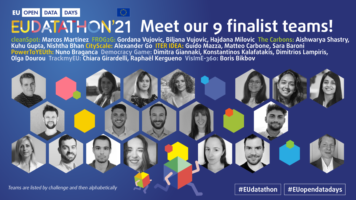
CleanSpot, the Spanish presence in the contest
There were 12 proposals from Spanish teams for the EU Datathon 2021, one of them, CleanSpot, has achieved a place in the final, within the “A European Green Deal” category.
CleanSpot is an app that seeks to promote awareness and incentive of recycling through gamification. The app allows you to locate recycling and reuse points, such as clean points, specialized containers or collection services and centers. The novelty is that it also allows calculating the CO2 that each user avoids emitting into the atmosphere by performing a daily action such as throwing waste into the corresponding recycling container or donating it for reuse. Users can share their results and thus show the community how much they have reduced their carbon footprint, contributing to caring for the environment.
The users with the best score in the ranking receive prizes and recognition. In addition, each time the user goes to a collection or recycling point to deposit their waste, they accumulate points, which can be exchanged for discounts on municipal taxes, savings checks in local businesses or direct payments.
In addition, the app allows you to save favorite locations or services, and gives the option of receiving notifications, for example, reminders about the passage of the mobile clean point - for this service to be available in a specific municipality, prior integration is necessary -. It also allows the generation of awareness campaigns, with advice on recycling or information on specific actions in each area.
Finalists from 8 different countries
This year, the presence of finalists from multiple territories stands out. Only Italy repeats with three teams, one shared with France.
- In the category of “A European Green Deal”, CleanSpot will face each other with FROG2G, from Montenegro, and The Carbons, from India. FROG2G is an interactive visualization tool, created to offer a viable model to make Europe greener, while The Carbons allows you to compare the greenhouse gases that are emitted, for example, when you have a cup of coffee or take a drive.
- In the category "An economy that works for people", we find CityScale, from Ukraine, a tool to visualize, compare and find the best place to live; ITER IDEA, from Italy, a portal that facilitates the mobility of women in Europe; and PowerToYEUth, from Portugal, focused on locating public funding for SMEs and promoting youth employment.
- Finally, in the category “A Europe fit for the digital age”, the finalists are Democracy Game, from Greece, a virtual debate tool; TrackmyEU, from Italy and France, which makes it possible to explore EU policies, follow topics of interest and make the voice of the citizenry heard in Brussels; and VislmE-360, also from Italy, which offers a 360ᵒ view of visual impairments in the EU.
Next steps
The nine finalist teams have 5 months to develop their proposals, from June to November. Proposals will be evaluated by a jury of experts, based on criteria such as lThe open data used and the fitness for purpose. The winner will receive € 18,000, while the second and third will receive € 10,000 and € 5,000 respectively.
The award ceremony will be on November 25, 2021, within the framework of the EU Open Data Days, an event that this year has its first edition. In this event, aimed at push the use of open data in Europe to generate value, we will be able to see the various opportunities and business models offered by the reuse of public information.
Noticia
The Cross-Forest project combines two areas of great interest to Europe, as set out in the Green Deal. On the one hand, the care and protection of the environment - in particular our forests-. On the other hand, the promotion of an interoperable European digital ecosystem.
The project started in 2018 and ended on 23 June, resulting in different tools and resources, as we will see below.
What is Cross-Forest?
Cross-Forest is a project co-funded by the European Commission through the CEF (Connecting Europe Facility) programme, which seeks to publish and combine open and linked datasets of forest inventories and forest maps, in order to promote models that facilitate forest management and protection.
The project has been carried out by a consortium formed by the Tragsa Public Group, the University of Valladolid and Scayle Supercomputacion of Castilla y León, with the institutional support of the Ministry for Ecological Transition and the Demographic Challenge (MITECO, in Spanish acronyms). On the Portuguese side, the Direção-Geral do Território of Portugal has participated.
The project has developed:
- A Digital Services Infrastructure (DSI) for open forest data, oriented towards modelling forest evolution at country level, as well as predicting forest fire behaviour and spread. Data on fuel materials, forest maps and spread models have been used. High Performance Computing (HPC) resources have been used for their execution, due to the complexity of the models and the need for numerous simulations.
- An ontological model of forest data common to public administrations and academic institutions in Portugal and Spain, for the publication of linked open data. Specifically, a set of eleven ontologies has been created. These ontologies, which are aligned with the INSPIRE Directive, interrelate with each other and are enriched by linking to external ontologies. Although they have been created with a focus on these two countries, the idea is that any other territory can use them to publish their forest data, in an open and standard format.
The different datasets used in the project are published separately, so that users can use the ones they want. All the data, which are published under CC BY 4.0 licence, can be accessed through this Cross-Forest Github repository and the IEPNB Data Catalogue.
4 flagship projects in Linked Open Data format
Thanks to Cross-Forest, a large part of the information of 4 flagship projects of the General Directorate of Biodiversity, Forests and Desertification of the Ministry for Ecological Transition and the Demographic Challenge has been published in linked open data format:
- National Forest Inventory (IFN-3). It includes more than 100 indicators of the state and evolution of the forests. These indicators range from their surface area or the tree and shrub species that inhabit them, to data related to regeneration and biodiversity. It also incorporates the value in monetary terms of the environmental, recreational and productive aspects of forest systems, among other aspects. It has more than 90,000 plots. Two databases corresponding to a subset of the NFI indicators have been published openly.
- Forest Map of Spain (Scale 1:50.000). It consists of the mapping of the situation of forest stands, following a conceptual model of hierarchical land uses.
- National Soil Erosion Inventory (INES). This is a study that detects, quantifies and cartographically reflects the main erosion processes affecting the Spanish territory, both forest and agricultural. Its objective is to know its evolution over time thanks to continuous data collection and it has more than 20,000 plots.
- General Forest Fire Statistics. It includes the information collected in the Fire Reports that are completed by the Autonomous Communities for each of the forest fires that take place in Spain.
These datasets, along with others from this Ministry, have been federated with datos.gob.es, so that they are also available through our data catalogue. Like any other dataset that is published on datos.gob.es, they will automatically be federated with the European portal as well.
The predecessor of this project was CrossNature. This project resulted in the Eidos database, which includes linked data on wild species of fauna and flora in Spain and Portugal. It is also available on datos.gob.es and is reflected in the European portal.
Both projects are an example of innovation and collaboration between countries, with the aim of achieving more harmonised and interoperable data, facilitating to compare indicators and improve actions, in this case, in the field of forest protection.
Noticia
A symptom of the maturity of an open data ecosystem is the possibility of finding datasets and use cases across different sectors of activity. This is considered by the European Open Data Portal itself in its maturity index. The classification of data and their uses by thematic categories boosts re-use by allowing users to locate and access them in a more targeted way. It also allows needs in specific areas to be detected, priority sectors to be identified and impact to be estimated more easily.
In Spain we find different thematic repositories, such as UniversiData, in the case of higher education, or TURESPAÑA, for the tourism sector. However, the fact that the competences of certain subjects are distributed among the Autonomous Communities or City Councils complicates the location of data on the same subject.
Datos.gob.es brings together the open data of all the Spanish public bodies that have carried out a federation process with the portal. Therefore, in our catalogue you can find datasets from different publishers segmented by 22 thematic categories, those considered by the Technical Interoperability Standard.
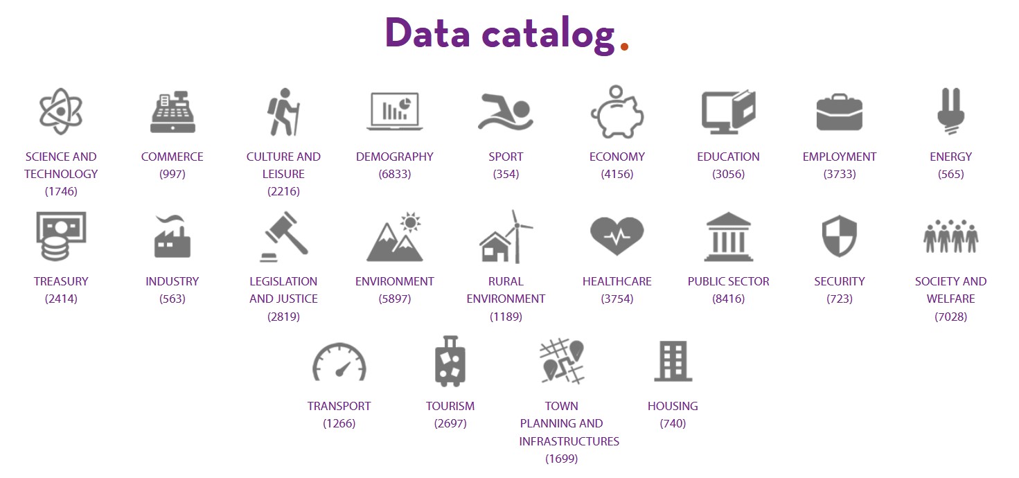
Number of datasets by category as of June 2021
But in addition to showing the datasets divided by subject area, it is also important to show highlighted datasets, use cases, guides and other help resources by sector, so that users can more easily access content related to their areas of interest. For this reason, at datos.gob.es we have launched a series of web sections focused on different sectors of activity, with specific content for each area.
4 sectorial sections that will be gradually extended to other areas of interest
Currently in datos.gob.es you can find 4 sectors: Environment, Culture and leisure, Education and Transport. These sectors have been highlighted for different strategic reasons:
- Environment: Environmental data are essential to understand how our environment is changing in order to fight climate change, pollution and deforestation. The European Commission itself considers environmental data to be highly valuable data in Directive 2019/1024. At datos.gob.es you can find data on air quality, weather forecasting, water scarcity, etc. All of them are essential to promote solutions for a more sustainable world.
- Transport: Directive 2019/1024 also highlights the importance of transport data. Often in real time, this data facilitates decision-making aimed at efficient service management and improving the passenger experience. Transport data are among the most widely used data to create services and applications (e.g. those that inform about traffic conditions, bus timetables, etc.). This category includes datasets such as real-time traffic incidents or fuel prices.
- Education: With the advent of COVID-19, many students had to follow their studies from home, using digital solutions that were not always ready. In recent months, through initiatives such as the Aporta Challenge, an effort has been made to promote the creation of solutions that incorporate open data in order to improve the efficiency of the educational sphere, drive improvements - such as the personalisation of education - and achieve more universal access to knowledge. Some of the education datasets that can be found in the catalogue are the degrees offered by Spanish universities or surveys on household spending on education.
- Culture and leisure: Culture and leisure data is a category of great importance when it comes to reusing it to develop, for example, educational and learning content. Cultural data can help generate new knowledge to help us understand our past, present and future. Examples of datasets are the location of monuments or listings of works of art.
Structure of each sector
Each sector page has a homogeneous structure, which facilitates the location of contents also available in other sections.
It starts with a highlight where you can see some examples of outstanding datasets belonging to this category, and a link to access all the datasets of this subject in the catalogue.
It continues with news related to the data and the sector in question, which can range from events or information on specific initiatives (such as Procomún in the field of educational data or the Green Deal in the environment) to the latest developments at strategic and operational level.
Finally, there are three sections related to use cases: innovation, reusing companies and applications. In the first section, articles provide examples of innovative uses, often linked to disruptive technologies such as Artificial Intelligence. In the last two sections, we find specific files on companies and applications that use open data from this category to generate a benefit for society or the economy.
Highlights section on the home page
In addition to the creation of sectoral pages, over the last year, datos.gob.es has also incorporated a section of highlighted datasets. The aim is to give greater visibility to those datasets that meet a series of characteristics: they have been updated, are in CSV format or can be accessed via API or web services.
What other sectors would you like to highlight?
The plans of datos.gob.es include continuing to increase the number of sectors to be highlighted. Therefore, we invite you to leave in comments any proposal you consider appropriate.
Noticia
The European Data Portal (EDP) has presented its report "Copernicus data for the open data community", prepared by con.terra as part of the EDP consortium. As we have reported before, Copernicus is the European Union's Earth Observation program that provides accurate, timely and easily accessible information to improve environmental management, understand and mitigate the effects of climate change and ensure civil security.
The report aims to help users harness the potential of Copernicus data to create Earth observation applications by answering three basic questions:
- What can I do with Copernicus data?
- How can I access the data?
- What tools do I need to use the data?
After an introduction reviewing the main activities and services available from the program, the report is divided into two parts: a first part where examples of Copernicus data applications are examined and a second, more practical part, where a particular use case is replicated in depth.
Copernicus use cases
The first part covers a series of possible use cases at a general level to answer the first of the questions posed above: what can be done with Copernicus data?
The use cases discussed are linked to the thematic areas addressed by the Copernicus program (emergency, security, marine, land, climate change and atmospheric monitoring), as well as to its services and tools. These examples cover the observation of plastic pollution of the oceans, land change due to mining activities, the impact of volcanic activities, ice loss, the creation of artificial islands, deforestation, forest fires, storms or pests.

The report highlights the importance of knowing what data are appropriate for each specific use case. For example, SENTINEL 2 MSI data is suitable for land monitoring, emergency management and security services, while SENTINEL 3 Altimetry data is linked to the areas of marine monitoring and climate change. To assist in this identification task, the guide includes references to various user guides with specifications on the missions, the instruments used to collect the data and the data products generated.
Case study on the use of Copernicus data
The second part of the report focuses on a particular use case that it addresses in depth, including how to download the appropriate data, process it and build applications with it. Specifically, it addresses the mapping of the lava flow of the Etna volcano using data from the Copernicus emergency management service. The aim is to track the impact of volcanic activities on nature and urban areas.
First, the report shows how to search and download data for this area of interest. In this case, Sentinel-2 products are used from the Copernicus Open Access Hub. The entry point for accessing the Copernicus data is their own website, which provides an overview of the data access points. Through different images, the report shows search and filter options to locate the appropriate data.

To visualize and process the data, it is proposed to use commercial software such as ArcGIS Pro, free GIS tools such as QGIS, open source processing tools such as SNAP or programming libraries such as GDAL. In the case of the example, SNAP (Sentinel Application Platform), the European Space Agency (ESA) platform, is used to view the lava flow.
Some explanations on workflow automation with the Open Access Hub API and the SNAPgraph tool are given at the end of the chapter.
Final conclusions
The report ends with several conclusions, among which the following stand out:
- Users can extract great value from Copernicus data but to do so they need to be familiar with the platforms involved and the necessary tools.
- For most use cases, it is necessary to combine Copernicus data with in situ data. The Copernicus program itself uses data from ground-based sensors, for example, for calibration and validation of its products.
Spain's role in Copernicus
The Ministry of Transport, Mobility and Urban Agenda, through the National Geographic Institute, and the Ministry for Ecological Transition (MITECO) represent Spain in the Copernicus User Forum, for the monitoring and evolution of the program. In this interview Nuria Valcárcel, Deputy Assistant Director (Observation of the Territory) of the General Directorate of Geodesy and Cartography, in the D.G. National Geographic Institute (IGN) delves into the services of Copernicus and its usefulness in the economic and social field.
In datos.gob.es you can also find this other interview with Stéphane Ourevitch, founder of SpaceTec, who participated as a speaker at the Encuentro Aporta 2019, where he tells us about the usefulness of data for space observation and how the Copernicus program promotes entrepreneurship through actions such as hackathons.
Copernicus data are very useful all over the world. In our country, we also find multiple services and applications developed based on Copernicus data, some of which are collected in this article.
Blog
More than 2.5 billion tonnes. That is the amount of waste that, according to the European Union, is produced every year in the EU - although the specific figure is from 2016 -, with the consequent danger to the environment and our own future. This worrying situation is leading the European institutions to promote a change of model in waste management.
For years, waste management has been linear, i.e. natural resources are extracted, used to produce a certain good, consumed and then discarded. This system requires large amounts of energy and cheap, easily accessible materials. Part of this model are also practices such as programmed obsolescence, very common in the technological field, where the company "programs" the end of the useful life of the product, in such a way that after a certain period of time it stops working.
This linear model is not viable in the long term, which is why more and more people are calling for a change to a management based on the circular economy.
What is the circular economy?
Circular economy refers to an economic system that replaces the concept of 'end-of-life' with 'reduce, reuse, recycle and recover materials in the production, distribution and consumption processes'. In other words, instead of discarding products, they re-enter the production cycle, which contributes to creating environmental quality, economic prosperity and social equity for the benefit of current and future generations.
Through these actions, we can maximise the life cycle of products and minimise waste. When a product ceases to function, its materials can still be used to create new products and remain in the economy wherever possible.
There are many benefits to this practice, from reduced greenhouse gas emissions to financial savings for businesses and consumers, who can benefit from longer-lasting products.
How does open data contribute to fostering the circular economy?
As in other fields, information obtained through open data can help drive better decision-making on the efficient use of resources. Data can help train algorithms to predict certain trends and help citizens, administrations and businesses to implement the necessary measures to ensure a sustainable future.
In its article ‘Open Data and the Circular Economy’, the European Data Portal details 3 areas where open data has a major impact on the circular economy:
- A more sustainable food system. Open data can help solve logistical problems, improve efficiency and ensure food security. Data on production and distribution, temperature changes of products, rising water levels or mapping of deforestation can improve strategic decision-making to regulate supply and demand across Europe, avoiding over-consumption of resources. In this regard, an example is Smartchain's open data-based research, which aims to develop a shorter and more sustainable food supply chain.
- Efficient resource management and waste optimisation. The selective collection process and the use of the total capacity of recycling plants can be improved with the right information. In this regard, Santiago City Council has implemented a smart municipal solid waste collection system using IoT technology and machine learning algorithms enriched with open data. In this area, citizen awareness is also fundamental through apps such as EcoCity, which monitors waste management in cities and sets a series of targets to improve urban recycling habits and reduce waste generation. Users can choose the recycling bin they want to monitor in their neighbourhood. If they detect any incidents with the registered bins, they can send a warning directly to the local council.
- Pollution reduction. Open data on contamination of the air or our seas helps to raise awareness of pollution and its health risks. This type of information can improve the decision-making process to protect the health of EU citizens and the environment through preventive measures, such as halting the expansion of London Heathrow Airport. Applications and visualisations such as the National Air Index, Aire.cat or this freshwater ecosystem explorer show indicators that raise awareness of the reality of our environment.
How Europe's circular economy is progressing
The European Commission presented last March 2020, in the framework of the European Green Pact, a new Circular Economy Action Plan which includes proposals on designing more sustainable products, reducing waste and empowering citizens (such as the "right to repair").
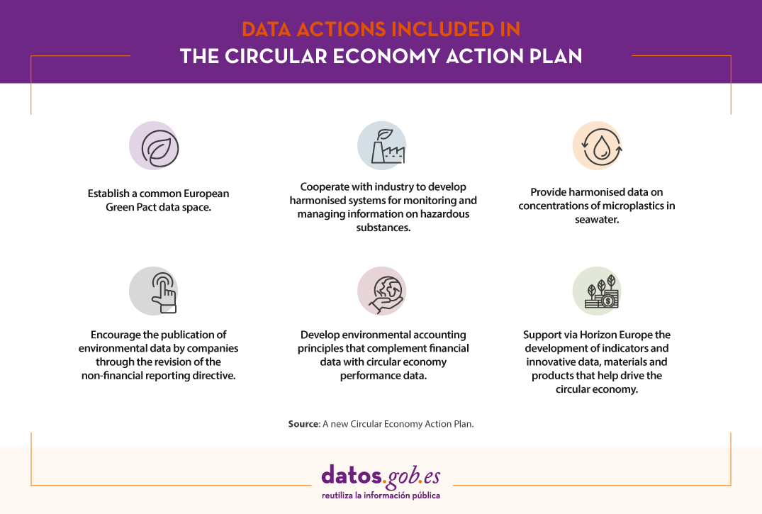
In addition, in order to effectively and efficiently implement the new sustainable products framework, the Commission is pursuing a number of data actions such as:
- Establish a common European Green Pact data space for smart applications with data on value chains and product information.
- Provide harmonised data on concentrations of microplastics in seawater.
- Cooperate with industry to develop harmonised systems for monitoring and managing information on hazardous substances, in synergy with measures under the sustainable product policy framework and the European Chemicals Agency (ECHA).
- Encourage the publication of environmental data by companies through the revision of the non-financial reporting directive.
- Support a business initiative to develop environmental accounting principles that complement financial data with circular economy performance data.
- In addition, Horizon Europe will support the development of indicators and innovative data, materials and products that help drive the circular economy.
In our country, the promotion of the circular economy is marked by the Spanish Circular Economy Strategy 2030 (EEEC), whose objectives for 2030 include reducing waste generation by 15% compared to 2010, improving water use efficiency by 10% and reducing greenhouse gas emissions to below 10 million tonnes of CO2 equivalent.
We live in a context of increasing demand for raw materials and scarcity of resources. Many raw materials are finite and, as the world's population increases, so does demand. The circular economy is therefore a key element for the optimal development of the future of the entire population. Within all the initiatives that are already underway, data can play a key role in increasing our knowledge and driving technologies that help all citizens to move towards a sustainable future.
Content prepared by the datos.gob.es team.
Noticia
Care for the environment is an aspect that has been of concern to a large part of society for several years now. It is clear that we have reached a turning point that makes us see the need to act as soon as possible to avoid further damaging our planet. Therefore, we citizens must change our habits if we want to see a real change in this situation.
Recently we have seen how the new generations are the ones who are most aware of the need to take proper care of the environment at a global level. At this point, change becomes more than necessary and new technologies can play a fundamental role in helping us to take care of our planet.
Did you know that open data is very useful in overcoming environmental challenges? In addition to providing us with accurate information to understand the problem and to be able to search for effective solutions, open data allows us to implement solutions that raise awareness in society and make it easier for us to protect the environment.
Currently, in our portal you can find diverse content on applications related to the environment, cases of use of open data to fight climate change, in addition to 6,000 datasets related to this field.
Below, we highlight some of the environmental datasets that you can find in our catalogue to reuse and develop new applications and services that can drive improvements in this field.
These are the types of environment-related data you can find at datos.gob.es
In our portal you can find a wide catalogue of data classified by different sectors. The Environment category has different datasets that can help in the fight against climate change, deforestation or environmental degradation, threats faced by the whole world.
Of these datasets, the following are the most important ones, together with the format in which you can consult them:
-
At the state level
- Centre for Sociological Research (CIS). Ecology and environment. ASCII.
- Ministry of the Interior. Nature conservation: environment-related offences. XLSX.
- National Parks Autonomous Agency. Natural systems in national parks. SHP, HTML.
- Confederación Hidrográfica del Guadalquivir. Distribution of invasive species in the Guadalquivir river basin. HTML, WFS, WMS, SHP, KMZ.
- Renfe – Operator. Main sustainability indicators. XML, JSON, CSV, TURTLE, RDF.
- INE. Statistics on Waste Collection and Treatment. CSV, XLSX.
-
At Autonomous Community level
- Xunta of Galicia. Air quality data. XLS, JSON, RSS.
- Basque Government. Cartography of the Open Catalogue of Relevant Natural Spaces. SHP, WMS.
- Castilla y Leon Government. Camping area in natural spaces. GML, SHP, KML, CSV.
- Government of Aragon. Special Conservation Areas de Especial. JSON, CSV, KMZ, SHP, GML, XML-APP.
- Autonomous Community of Madrid. Reforestation. JSON, CSV.
-
A the local level
- Santander City Council. Environmental News. RDF-XML, XML-APP, JSON, RDF, CSV, Atom, RDF-Turtle, HTML, RSS.
- Cáceres City Council. Cáceres rubbish collection points. SPARQL, RDF-Turtle, CSV, XLS, JSON.
- Valencia City Council. Location of domestic oil containers. WMS, KML, GML, WFS, KMZ, OCTET-STREAM, JSON, CSV.
- Vigo City Council. Forest Parks (Points of Tourist Interest). CSV, JSON, KML, ZIP, XLS, CSV.
- Alcobendas City Council. Environment. Waste collection. ODS, XLS, XML, CSV, JSON.
- Madrid City Council. Clean Proximity Points. RSS, XLS, CSV.
Some examples of environmental data reuse
The power of datasets related to this field is of tremendous value. Thanks to them, it is possible to create new tools that facilitate aspects such as the care of the environment or the fight against climate change. An example of this is the National Air Quality Index, which makes it possible to check, in real time and in a simple way, the state of the air quality marked by the 506 measurement stations of the national monitoring network. Or Förecast, an application with real-time data on forest stocks that allows spatial-temporal analysis and thus optimises forest management.
Do you know of any company that uses this type of data or an application that relies on it to help care for the environment? Then do not hesitate to leave us a comment with all the information or send us an email to contacto@datos.gob.es. We will be happy to read you!
Blog
Climate change, air pollution and sea pollution. These are the 3 main environmental problems for Spanish citizens according to the latest Eurobarometer "Attitudes of European citizens towards the Environment", published in March 2020. The survey also highlights that 90% of the Spanish population considers to protect the natural environment important. Citizens want more action to be taken and believe that responsibility should be shared between companies, national governments, the EU and citizens themselves.
As with other sectors, such as education or health, open data can also help us to overcome environmental challenges. On the one hand, it provides us with detailed information to understand the situation and to be able to look for solutions. On the other hand, they serve to implement solutions that help us raise awareness and reduce our environmental footprint.
In its report "The Economic Impact of Open Data Opportunities for value creation in Europe”, ", the European Data Portal highlights that data can "contribute to reducing total energy consumption in Europe, increasing the use of sustainable energy sources, protecting biodiversity and raising awareness of CO2 emissions", as well as generating an economic impact of around 1€ billion. Let's look at some examples:
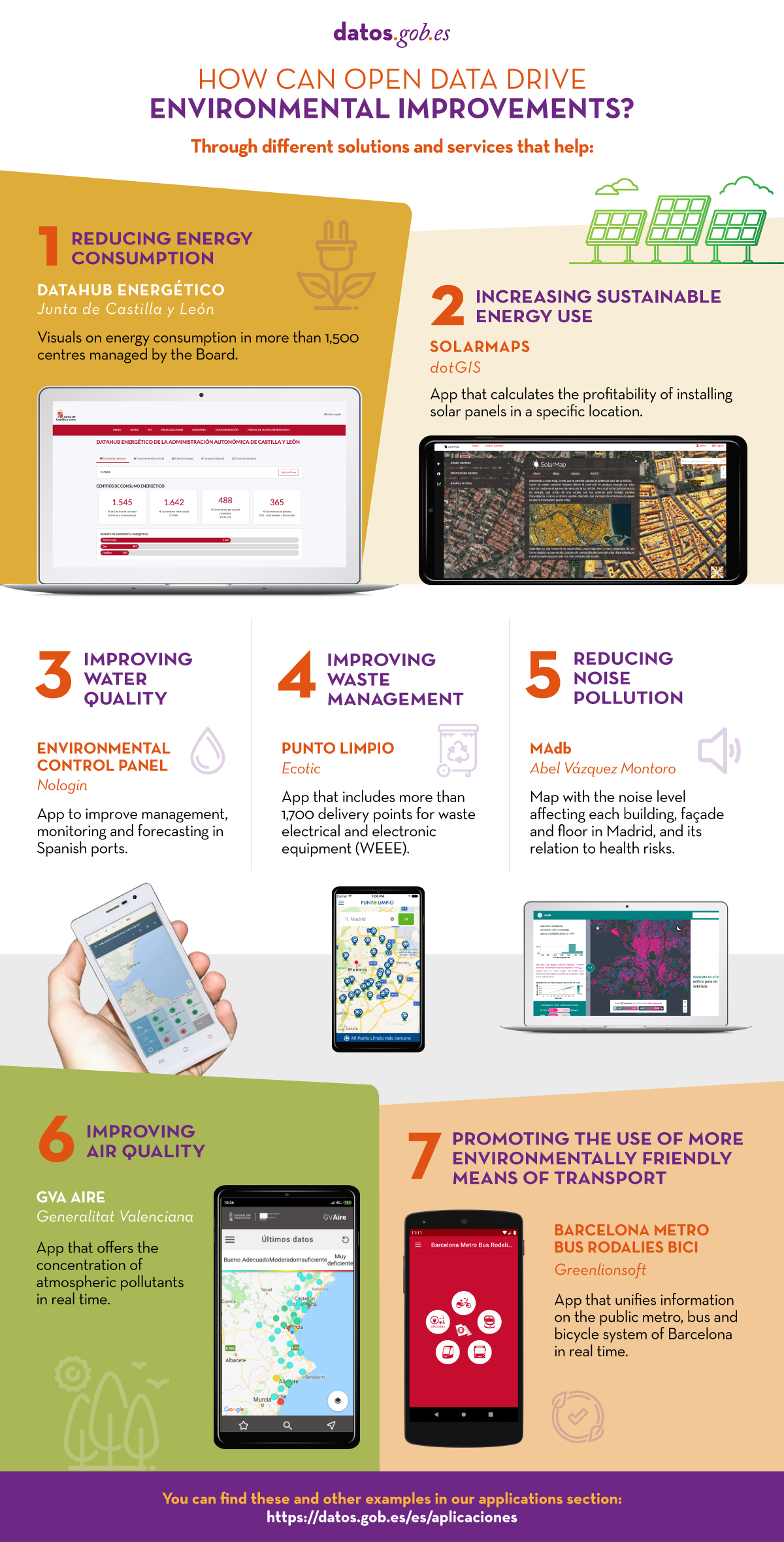
- Reducing energy consumption. Open data-based applications can serve as a tool to help households and institutions to understand and reduce their energy consumption. In this sense, the Regional Government of Castilla y León has launched an Energy Datahub that provides detailed and visual information on energy consumption in the more than 1,500 centres managed by the Regional Government: educational centres, health centres, administrative offices, hospitals, etc. The scorecard facilitates the disaggregated analysis by type of energy (electricity, gas, diesel) and by geographical location, allowing informed decisions to be made. According to the Board itself, thanks to the energy scorecard they have saved more than 12 million euros in electricity since 2015.
- Increase the use of sustainable energy. The 2018 EU directive on the promotion of the use of energy from renewable sources sets a target for the share of renewable energy in gross final consumption to be 32% by 2030. To help achieve this target, publicly available data on urban planning, use of public services or weather conditions can be cross-checked to create solutions that help make housing more sustainable. One example is Solarmap, which allows the profitability of a solar panel installation to be calculated for a specific location.
- Improving biodiversity: Changes in ecosystems can lead to mass extinctions of species and the limitation of available natural resources, which can affect not only our economy but also our own way of life. In this sense, open data serves as a basis for solutions that, for example, help us monitor various parameters of port waters (such as Environmental Control Panel), improve waste management (Punto limpio) or publicise noise pollution (MAdb).
- Raise awareness of air pollution and the reduction of CO2 emissions. Although, as we saw at the beginning of this article, we Spaniards are very aware of climate change, however, if we look at the individual habits of citizens, we see that there is still much to be done. Only 38% try to reduce their energy consumption, 28% choose less polluting forms of transport, and 36% buy local products. It is therefore necessary to continue raising awareness, for example through indicators of air quality in cities such as GV Aire. There is also a need for applications that promote the use of more efficient means of transport, such as bicycles or public transport (Barcelona metro bus rodalies bici).
You can find more examples in the applications section of datos.gob.es and in our environment section.
Blog
Just a few months ago, in November 2019, Ursula von der Leyen, still as a candidate for the new European Commission 2019-2024, presented the development of a European Green Deal as the first of the six guidelines that would shape the ambitions of her mandate.
The global situation has changed radically in the little more than six months since then due to the impact of the COVID-19 pandemic and as a result, many strategic plans of companies in practically all sectors and many roadmaps and roadmaps have been blown up. public policies of governments. Despite the great uncertainty in which we find ourselves, what is clear is that a thorough review will have to be undertaken to adapt these policies and plans to the new reality that is still taking shape.
However, it seems certain that the need and convenience of the European Green Deal has been reinforced in the current context. The Green Deal was conceived as an engine for the transformation of the European economy in the coming decades, but circumstances have made it a fundamental pillar for the reconstruction of the European economy in the short term after the shock induced by the confinements of the population.
In this sense, the European Union has an important advantage over other global players and that is to a large extent that its priorities are already aligned with the main challenges that we will face as the health crisis subsides. In any case, an EU growth strategy that aims to turn Europe into a continent without polluting emissions by 2050 may not seem ambitious enough to us now and we may even deem it pertinent to accelerate this transition.
The plan for the roll-out of the European Green Deal was published with a very ambitious tentative timetable that foresees the development between 2020 and 2021 of actions corresponding to the main key areas: climate ambition, clean, safe and affordable energy, industrial strategy for the economy circular and clean, sustainable and intelligent mobility, common agricultural policy beneficial to the environment and zero pollution and toxic-free environment.
If we analyze the main areas of action of the Green Deal, we clearly see that innovations based on data and artificial intelligence, together with other specific technologies, will be key to solving a good part of the challenges it aims to address. And of course all the documents already published recognize this, integrating data, open data, artificial intelligence and other technologies in the different planned actions. Those that are already available clearly indicate the path that the lines of work that will be approved in the coming years will follow.
EU strategy on biodiversity by 2030
The European biodiversity strategy to reintegrate nature into our lives, published on May 20, 2020, recognizes that “investment in research, innovation and knowledge sharing will be key to obtaining the best data and developing the best nature-based solutions”. As an example, he cites the European Forest Health Assessment, where the European Commission commits to "work with other data providers to further develop the Forest Information System for Europe." These commitments represent a good opportunity for the Spanish forestry sector on its way to transition towards a precision forestry industry approach.
Furthermore, the strategy expressly cites "the need to eliminate bycatch of endangered species or reduce them to a level that allows full recovery." To this end, it is proposed to intensify the collection of data on bycatch of all sensitive species. In this sense, the awarded project in the Aporta 2019 challenge is oriented, Optimatics System, which is designed to help fishermen make decisions in real time and thus rationalize fishing in the fishing grounds.
Ultimately, the European Biodiversity Strategy aims for research and innovation to help the Commission support and finance investments in nature-based solutions by providing objective criteria to prioritize 'green' solutions over 'gray' solutions.
Farm-to-table strategy
The “farm to table” strategy for a fair, healthy and environmentally friendly food system, also published on May 20, 2020, aims to ensure that Europeans have affordable and sustainable food, combat climate change, protect the environment and biodiversity and increase organic farming. This ambitious line of action also integrates the use of data and artificial intelligence in numerous places.
For example, it recognizes that the Common European Data Space on Agriculture, defined in the European Data Strategy, “will enhance the competitive sustainability of Union agriculture through the processing and analysis of data on production, land use, environment and of other types”, to then clarify that these data will allow “the precise and adapted application of the production approaches at the farm level and the monitoring of the results of the sector, in addition to supporting the initiative on carbon sequestration in soils agricultural”. That is, a clear orientation towards precision agriculture.
The key tool to achieve these objectives and for the transition to be fair and beneficial for all is the Common Agricultural Policy, which must be fully aligned with the Green Pact. The new CAP, proposed by the Commission in June 2018, aims to help farmers improve their performance as measured by environmental and climatic criteria. To do this, it proposes, for example, better use of data and analytics and a greater emphasis on investment in green and digital technologies and practices.
The European Union programs Copernicus and the European Sea Observation and Information Network (EMODnet), major open data sources, are cited for their contribution to reducing investment risks and as facilitators of sustainable practices in the fishing and aquaculture sector.
The improvement of data collection systems such as the 2009 Regulation on pesticide statistics or the Agricultural Accounting Information Network are also under attention and improvements are planned that will contribute both to fill the current gaps in the available data, how to promote evidence-based policy making.
New Action Plan for the circular economy
The New Action Plan for the circular economy for a cleaner and more competitive Europe, published on March 11, 2020, also recognizes a decisive role for research, innovation and digitization and therefore data during the transition. In this line, it is intended, for example, to promote the dissemination of environmental data by companies, which will force them to improve their systems for data capture and monitoring of objectives.
In the same way, innovation models based on massive customization or a closer relationship with customers are mentioned, which can accelerate the circularity and dematerialization of our economy. These models will only be possible using intensively data and artificial intelligence combined with other technologies such as blockchain or internet of things.
In addition, the European Commission will define a European data space for smart circular applications, with data on value chains and product information that will provide the architecture and governance system necessary to promote applications and services such as product passports, mapping of resources and information to consumers.
As part of the plan, the indicators, and therefore the data collection systems, on the use of resources will continue to be developed, in particular with regard to consumption and material footprints, which will be associated with the monitoring and evaluation process. of the advances obtained.
Open data
Finally, it is worth highlighting how open data is being used at the European level to promote the development of new solutions. The open data competition organized annually by the European Union, the EUDatathon, dedicated the first of its four challenges to the European Green Deal in 2020. The European Union Publications Office, organizer of the competition, has received 30 proposals (25% of the total) addressed to this challenge, which is a remarkable success considering the novelty of a concept forged only in recent months.
This interest from the open data community has also been reflected in the Spanish participation, which, with 4 proposals, has been the second country most committed to the Green challenge. Among the 3 shortlisted proposals for the final phase, there is a Spanish one, Dataseeds, which aims to help SMEs in the agriculture sector to contribute to the ecological restructuring of the EU industry.
Undoubtedly, the new growth strategy of the European Union represents a new source of opportunities for all economic sectors, but in all of them data will represent a key factor for their development, increasing the potential of other technologies such as intelligence. artificial knowledge and specific knowledge of each domain. And in Spain we have enormous potential both in the form of natural resources and in the form of capacities that can take advantage of this source of opportunities and generate competitive advantages in many sectors during this transition that has just begun.
Content prepared by Jose Luis Marín, Senior Consultant in Data, Strategy, Innovation & Digitalization.
The contents and points of view reflected in this publication are the sole responsibility of its author.