11 posts found
Data Sandboxes: Exploring the potential of open data in a secure environment
Data sandboxes are tools that provide us with environments to test new data-related practices and technologies, making them powerful instruments for managing and using data securely and effectively. These spaces are very useful in determining whether and under what conditions it is feasibl…
Open geographic data applications of the National Centre for Geographic Information (NICHD)
The National Centre for Geographic Information publishes open geospatial data from the National Cartographic System, the National Geographic Institute and other organisations through web applications and mobile applications to facilitate access to and consultation of geographic data by citizens.
Geo…

What is the value of open geographic data?
Geographic data allow us to learn about the world around us. From locating optimal travel routes to monitoring natural ecosystems, from urban planning and development to emergency management, geographic data has great potential to drive development and efficiency in multiple economic and social area…

The importance of the Telco sector in the deployment of a Digital Europe
Building Europe's digital infrastructure of tomorrow
As a global technology race unfolds, Europe is deploying the regulatory framework and investments needed to foster innovation and technological leadership in areas such as online platforms, artificial intelligence, data, cloud, quantum technologie…

Our first digital navigation. Open source alternatives to Google Maps
In the vast technological landscape, few tools have made as deep a mark as Google Maps. Since its inception, this application has become the standard for finding and navigating points of interest on maps. But what happens when we look for options beyond the ubiquitous map application? In this post w…

Emerging Trends in Geospatial Data and AI
On September 8, the webinar \"Geospatial Trends 2023: Opportunities for data.europa.eu\" was held, organized by the Data Europa Academy and focused on emerging trends in the geospatial field. Specifically, the online conference addressed the concept of GeoAI (Geospatial Artificial Intelligence), whi…

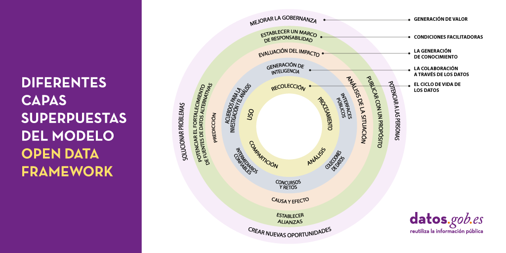
Peeling the onion of open data governance
One of the key actions that we recently highlighted as necessary to build the future of open data in our country is the implementation of processes to improve data management and governance. It is no coincidence that proper data management in our organisations is becoming an increasingly complex and…
The Spatial Data Infrastructure of Spain (IDEE), a benchmark for geospatial information
Throughout history, geospatial data have allowed humankind to better understand its environment. When we talk about geographic or spatial data, we refer to data "that implicitly or explicitly refer to a location relative to the Earth", according to the Spanish Standard UNE 148004:2018. Generally, th…

Laboratories for innovation in data management
Current approaches to public policy-making that respond quickly to changing trends in technology are too often unsuccessful. Policy makers are often pressured to develop and adopt laws or guidelines without the evidence needed to do so safely and without the opportunity to consult affected experts a…

Use Cases of Copernicus data in Spain
Copernicus is one of the geospatial data programmes that is most in demand and the focus of attention of various organisations, private companies and citizens. The programme is run jointly by the European Space Agency (ESA) and the European Union through the European Environment Agency, and has two…
