18 posts found
The role of data in driving autonomous vehicles
Just a few days ago, the Directorate General of Traffic published the new Framework Programme for the Testing of Automated Vehicles which, among other measures, contemplates "the mandatory delivery of reports, both periodic and final and in the event of incidents, which will allow the DGT to assess…

DGT datasets to help improve traffic and road safety
The General direction of traffic (DGT in its Spanish acronym) is the body responsible for ensuring safety and fluidity on the roads in Spain. Among other activities, it is responsible for the issuing of permits, traffic control and the management of infringements.
As a result of its activity, a larg…

Open data for navigating cities
Open data can transform how we interact with our cities, offering opportunities to improve quality of life. When made publicly available, they enable the development of innovative applications and tools that address urban challenges, from accessibility to road safety and participation.
Real-time inf…

How Google, Moovit and Citymapper reuse open mobility data
Many people use apps to get around in their daily lives. Apps such as Google Maps, Moovit or CityMapper provide the fastest and most efficient route to a destination. However, what many users are unaware of is that behind these platforms lies a valuable source of information: open data. By reusing p…

Complying with Europe. The Mobility High Value Datasets Regulation
Spain, as part of the European Union, is committed to the implementation of the European directives on open data and re-use of public sector information. This includes the adoption of initiatives such as the Implementing Regulation (EU) 2023/138 issued by the European Commission, whic…

Big Data Test Infrastructure: A free environment for public administrations to experiment with open data
The Big Data Test Infrastructure (BDTI) is a tool funded by the European Digital Agenda, which enables public administrations to perform analysis with open data and open source tools in order to drive innovation.
This free-to-use, cloud-based tool was created in 2019 to accelerate d…

Segment Anything Model: Key Insights from Meta's Segmentation Model Applied to Spatial Data
Image segmentation is a method that divides a digital image into subgroups (segments) to reduce its complexity, thus facilitating its processing or analysis. The purpose of segmentation is to assign labels to pixels to identify objects, people, or other elements in the image.
Image segmentation is c…

European Webinars: Monitoring Climate Change and Digital Development with Open Data
The "Stories of Use Cases" series, organized by the European Open Data portal (data.europe.eu), is a collection of online events focused on the use of open data to contribute to common European Union objectives such as consolidating democracy, boosting the economy, combating climate change, and driv…

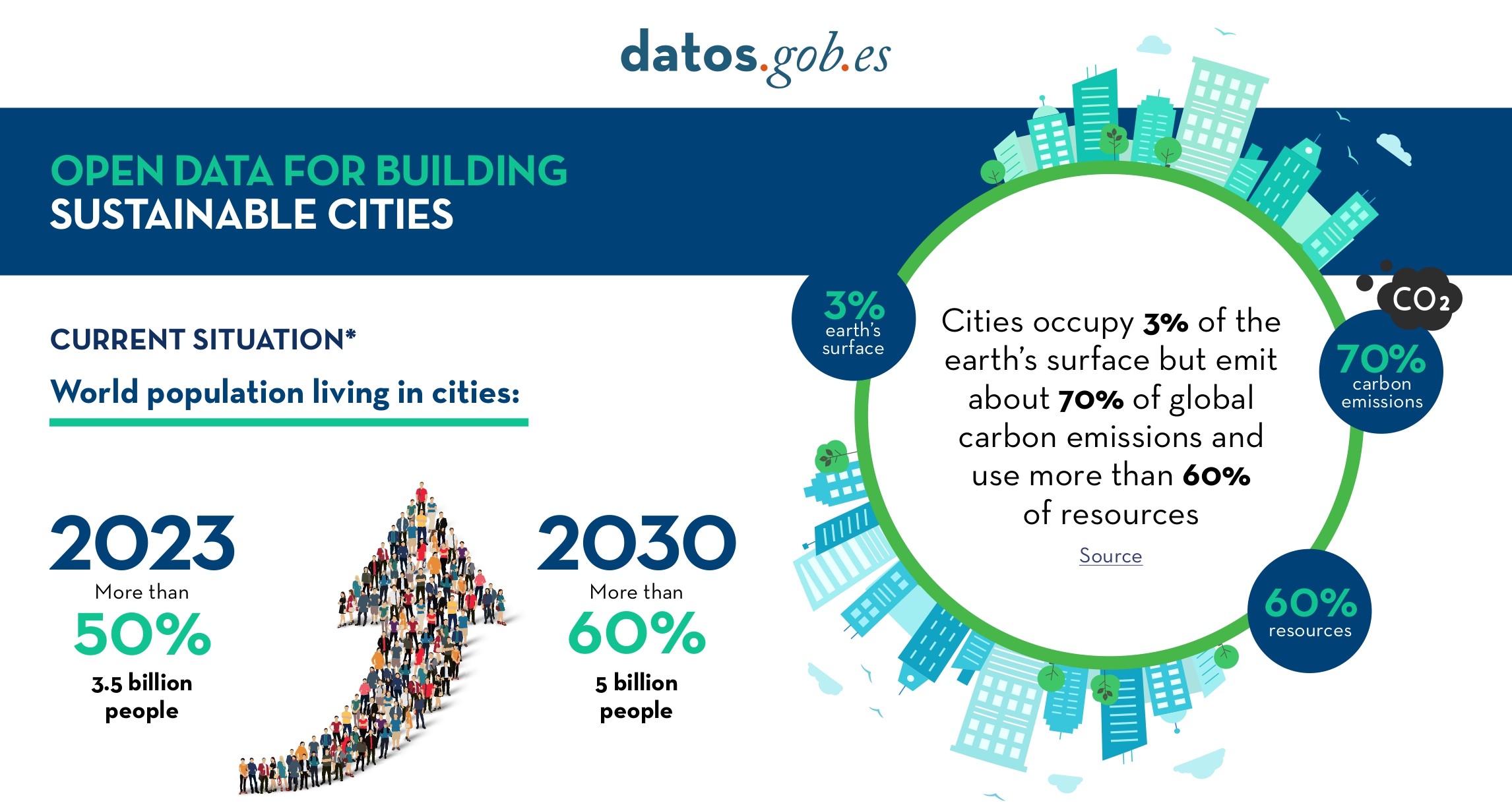
Open Data for Sustainable City Development
Open data is a valuable tool for making informed decisions that encourage the success of a process and enhance its effectiveness. From a sectorial perspective, open data provides relevant information about the legal, educational, or health sectors. All of these, along with many other areas, utilize…
X-ray of the national Tourism dataspace: Challenges and opportunities for the tourism sector.
The Spanish Hub of Gaia-X (Gaia-X Hub Spain), a non-profit association whose aim is to accelerate Europe's capacity in data sharing and digital sovereignty, seeks to create a community around data for different sectors of the economy, thus promoting an environment conducive to the creation of sector…